Showing 6700 items
matching river
-
 Eltham District Historical Society Inc
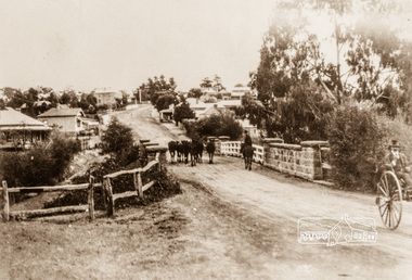
Photograph, Main Street, Greensborough, c.1900, 1900c
Shows view looking up Main Street, Greensborough across the Plenty River BridgePhotograph copy originally located in a magnetic style album titled 'Greensborough Bypass 1990s 5' suffering significant degradation. No information contained in album or on reverse of photos except where noted. Relocated to archival photosafe storage.greensborough, main street, plenty river bridge -
 Eltham District Historical Society Inc
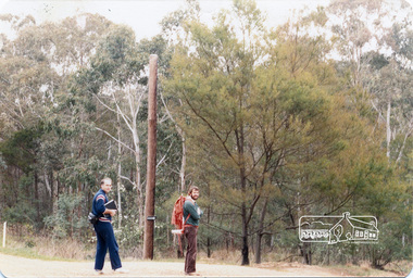
Photograph, Long Gully and environs, Watsons Creek catchment, c.Oct 1982, 1982
Looking for a route for a walking trail from Kinglake to the Yarra River. Not shown is Rod Roscholler. Colour photograph1982, long gully, watsons creek, lodi francesconi, russell yeoman -
 Eltham District Historical Society Inc
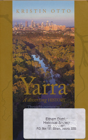
Book, Text Publishing, Yarra: a diverting history by Kristin Otto, 2009
Exploration of the history and meaning of Melbourne's Yarra river and those who have lived and worked on it. Softcover, 245 p. : ill. maps, ports. ISBN 9781921520006yarra river -
 Tatura Irrigation & Wartime Camps Museum
Program, Goulburn Weir Rehabilitation Works Opening Ceremony
Includes weir construction history, aboriginal names of Victoria, map, Goulburn River systemProgram of Opening Ceremony. White paper, black writing, blue water wheel logo in plastic sleeveirrigation, document, program, rural, industry -
Tatura Irrigation & Wartime Camps Museum
Audio Tape, Taped talk by Bert Gloster
Taped talk by Bert Gloster who at one time worked on the River Boats at Echuca.audio, visual, technology, accessory -
 Malmsbury Historical Society
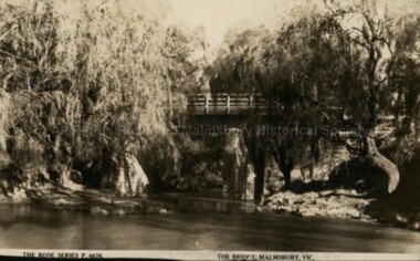
Postcard (Item), Postcard Of The Bridge Malmsbury Rose Series P4676, Malmsbury c1927
Associated with - Rose Series P4676 Buildings - "Bridge, Coliban River" People - "Leadbeater, Mr." -
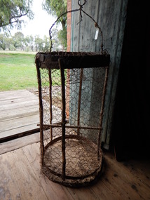 Parks Victoria - Days Mill and Farm
Container - Traps
Possibly used for catching freshwater crayfish or yabbies, nearby in the Goulburn River or other waterways. of critical significanceHOMEMADE WIRE TRAPS x 2. Made from chicken wire. Iron bands supported by green timber lengths. Wire handles with metal spike probably for securing trap to bank/ ground.fishing, food -
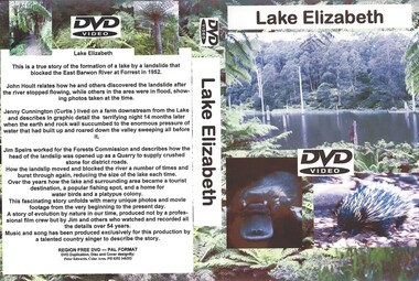 Otway Districts Historical Society
DVD, Lake Elizabeth, 2006
Lake Elizabeth was formed when a landslide slid into the valley damming the East Barwon River.Interviews with people who remember the formation of the Lake.30 Minute video of the creation of the lake in 1952lake elizabeth forrest east barwon -
 Brimbank City Council Art Collection
Reproduction black and white photograph, Flemington 1850
Photograph of re-enactment of the Australian landing at Gallipoli on Saltwater river. ANZAC day 1919Reproduction black and white photograph, 33 x 23 cm -
 Lakes Entrance Historical Society
Photograph - Warm Hole, Lakes Post Newspaper, 1993
The Warm Holes are the remnants of Reeves River, the original waterway of the natural entrance to the Gippsland Lakes.Black and white photograph of the fourth warm hole, looking eastward, Lakes Entrance, Victoria. waterways, vegetation -
 Lakes Entrance Historical Society
Photograph - Cowrie Bay, 1980c
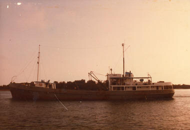
Skipper John Britton, Scott Hobson?, thought to be in mud in Tamar River, Tasm 2011Colour photograph of fishing boat Cowrie Bay which appears to be just outside Cunninghame Arm, the western side of the entrance and hummocks in background. Lakes Entrance Victoriafishing industry, ships and shipping, waterways -
 Greensborough Historical Society
Map, Melbourne and Metropolitan Board of Works. Survey Division, MMBW, Yarra 2500 / 13.24. Plenty, Memorial Drive, 1979_03
Melbourne and Metropolitan Board of Works. Yarra 2500 [base map] 13-24. Plenty, Memorial Drive. Parish of Morang 3183. Municipalities of Diamond Valley 257 and Whittlesea 239. Prominent streets include: Oatland Road, River Avenue and Memorial Drive. Includes Plenty River and SEC Transmission easement.MMBW Map in 1:2500 [scale] series. Cream parchment with green tape reinforcing on edges and punched holes on left edge.mmbw, melbourne and metropolitan board of works, shire of diamond valley, plenty - maps -
 Orbost & District Historical Society
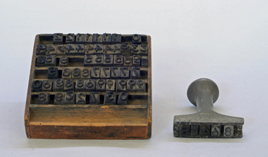
stamp holder and numbers, Victorian Government Railways, c. 1930s- 1980s
Used on the Orbost-Bairnsdale railway line which closed in 1987. The Bairnsdale-Orbost railway was opened in 1916 to serve the agricultural and timber industry. Because of the decline in traffic and heavy operating costs, the line was finally closed in August, 1987. Orbost Railway Station was opened on Monday 10 April 1916 as the terminus of the Orbost railway line, and closed in 1987. The station was located on the west side of the Snowy River despite the town of Orbost being on the east side of the river, in order to save on the costs of a bridge over the river, which at the time had highly variable levels This item is associated with the history of the Orbost-Bairnsdale railway line and therefore reflects the role that the rail line played in the social and economic history of Orbost.A stamp holder made of aluminium into which numbers and possibly letters can be inserted. Also a square shallow wooden box containing numbers which are used with the stamp. The numbers appear to be made of rubber.possibly V G R railway-history orbost-bairnsdale-railway -
 Orbost & District Historical Society
Victorian Railways pencil, Victorian Railways, c. 1960s-1980s
Used by Victorian Railways at stations on the Orbost-Bairnsdale line. The Bairnsdale-Orbost railway was opened in 1916 to serve the agricultural and timber industry. Because of the decline in traffic and heavy operating costs, the line was finally closed in August, 1987. Orbost Railway Station was opened on Monday 10 April 1916 as the terminus of the Orbost railway line, and closed in 1987. The station was located on the west side of the Snowy River despite the town of Orbost being on the east side of the river, in order to save on the costs of a bridge over the river, which at the time had highly variable levels. This item is associated with the history of the Orbost-Bairnsdale railway line and therefore reflects the role that the rail line played in the social and economic history of Orbost.A thick, hexagonal shaped pencil made of wood, painted dark blue, containing blue graphite marker.VICTORIA RAILWAYS written in gold lettering Emperor, Made in Australia railway-history victorian-railways orbost-bairnsdale-railway -
 Orbost & District Historical Society
stamp, C 1960's
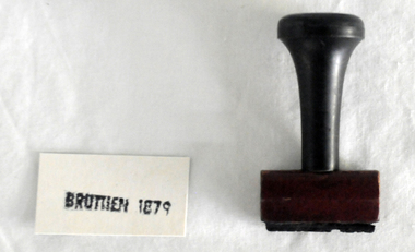
This stamp was used at the Orbost Railway Station. The Bairnsdale-Orbost railway was opened in 1916 to serve the agricultural and timber industry. Because of the decline in traffic and heavy operating costs, the line was finally closed in August, 1987. Orbost Railway Station was opened on Monday 10 April 1916 as the terminus of the Orbost railway line, and closed in 1987. The station was located on the west side of the Snowy River despite the town of Orbost being on the east side of the river, in order to save on the costs of a bridge over the river, which at the time had highly variable levels This item is associated with the history of the Orbost-Bairnsdale railway line and therefore reflects the role that the rail line played in the social and economic history of Orbost.A stamp with a black plastic handle. The bottom is wood and the stamp rubber. It has "BRUTHEN 1879" on it."BRUTHEN 1879"orbost-railway-station -
 Orbost & District Historical Society
stamp, 1970's
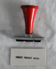
This stamp was used at the Orbost Railway Station. The Bairnsdale-Orbost railway was opened in 1916 to serve the agricultural and timber industry. Because of the decline in traffic and heavy operating costs, the line was finally closed in August, 1987. Orbost Railway Station was opened on Monday 10 April 1916 as the terminus of the Orbost railway line, and closed in 1987. The station was located on the west side of the Snowy River despite the town of Orbost being on the east side of the river, in order to save on the costs of a bridge over the river, which at the time had highly variable levels, This item is associated with the history of the Orbost-Bairnsdale railway line and therefore reflects the role that the rail line played in the social and economic history of Orbost.A stamp with a red plastic handle and a white stamping face - "ORBOST FREIGHT DEPOT".VUESTAMP AUSTRALIAorbost-railway -
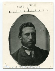 Orbost & District Historical Society
black and white photograph, 1840s - 1850s
James John Thomson was the first secretary of the Snowy River Shipping Company. The Snowy River Shipping Company was formed by Mr Henry James in 1880 with Captain McNeil as master. This photograph was taken off a one inch daguerrotype which was the first publicly available photographic process, widely used during the 1840s and 1850s.James John Johnston was a prominent citizen of Orbost in the late 19th / early 20th century.A black / white photograph of a man - an octagonal shape on a white buff card.on front above portrait - "One Inch" and a hand-drawn ruler. on front below portrait - in capitals and underlined "Mr J.J. THOMPSON"johnston-j.j. snowy-river-shipping-company -
 Kiewa Valley Historical Society
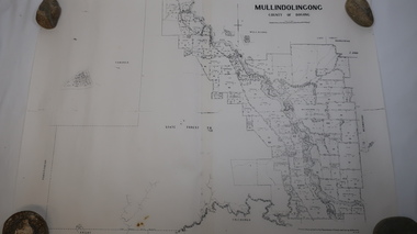
Map - Mullindolingong
Land owners of land in the Kiewa Valley in 1928The Kiewa Valley was farming country with families settling in the area prior to 1928 Two sheets the same: (one old with paper joined together and the other is a copy without any joins. 21 6 1928 dated Map of Mullindolingong / County of Bogong showing land owners along the Kiewa River and beyond.Produced by the Department of Lands and Survey, Melbournemullindolingong, kiewa valley, land owners, families of the kiewa valley -
 Federation University Historical Collection
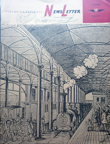
Magazine - Newsletter, Victorian Railways Newsletter, June 1967, 06/1957
Soft covered magazine of 16 pages. It includes an article of the Geelong Line centenary, and a photo of the original Geelong line laid with Barlow, or saddle-back rail; cement, Little River Station, , Renewing crossings, , memorial to railways returned servicement at the Ballarat NOrth Workkshops. victorian railwat, geelong railway centenary, cement, cp vans, railcrossings, trains -
Glenelg Shire Council Cultural Collection
Souvenir - Souvenir Wine Glass, c. 1985
Wine glass, souvenir of Heywood's 150th 1835 - 1985. Gold rim on top, gold depiction of bullock dray, with 'Heywood 150th' above and '1835 - 1985' below, in gold. Opposite side of glass has history of the Heywood Fitzroy River bridge in gold print.souvenir, heywood, 150th anniversary, 1835 to 1985 -
Glenelg Shire Council Cultural Collection
Photograph - Sheet of 2 contact prints - Various pastoral scenes, 1960-1970
Sheet of 2 contact prints from glass plate negatives. Top: Weatherboard house, verandah with iron lacework from roof, verandah roof striped. Several ladies and small children on verandah. Bottom: Five women standing on wooden jetty on river bank. -
 Warrnambool and District Historical Society Inc.
Cards, Post Cards Warrnambool, Early 20th century
These cards have been sent to Christina Lawrance (1889-1970). She was born in Williamstown, Victoria and married James Robertson in 1912. They lived in the Gundagai area of N.S.W. on a property named ‘Nargoon’ (sheep and cattle) and they had five children. One of the daughters, Margaret, married Jeffrey (Bill) Whitehead of ‘Goodwood’ near Hawkesdale and the cards have been passed on to us from a Whitehead descendant. It is not known who sent the cards to Christina Lawrance who would have been 16 or 17 at the time. These cards are of interest because they are of Warrnambool scenes and demonstrate the practice at the time (1906) of sending cards that had photographs of local scenes. The photographs, although printed in great numbers, are of historical interest today. The cards are also of interest because of the recipient’s connection with the Warrnambool area – Christina Lawrance is an important person in the family tree of the Whitehead families today. These are four colour post cards in green, yellow and black tonings. They have photographs of the Hopkins River, Warrnambool and the Hopkins Falls on one side. They all have a penny red Victorian stamp and were posted from Warrnambool in 1906. The address is handwritten in black ink. Addressed to: ‘Miss C. Lawrance, C/O Kirkpatricks Hotel, Mornington, Victoria’whitehead family of ‘goodwood’, christina robertson nee lawrance, history of warrnambool and district -
Bendigo Historical Society Inc.
Map - LYELL : COUNTY OF BENDIGO, 24-10-84
Map. Lyell, County of Bendigo, Eppalock, Sedgwick, Sutton Grange, Hawkestone, Kimbolton, Coliban River, Myrtle Creek. State School. Photo-Lithographed at the Department of Lands and Survey, Melbourne by J. Noune, 24-10-84. (number 71 in map cupboard 1)J. Nounemap, bendigo, lyell -
Bendigo Historical Society Inc.
Map - LYELL : COUNTY OF BENDIGO, 24-9-07
Map. Lyell, County of Bendigo, Sedgwick, Sutton Grange, Hawkestone, Kimbolton, Eppalock, Myrtle Creek, Coliban River. Photo-Lithographed at the Department of Lands and Survey, Melbourne by T.F. McGauran, 24-9-07, Price 1/-. (number 70 in map cupboard 1)T.F. McGauranmap, bendigo, lyell -
Bendigo Historical Society Inc.
Map - DERBY : COUNTY OF BENDIGO, 1-9-09
Map. Derby, County of Bendigo, Inglewood, Loddon River, Tarnagulla, Woodstock, Leichardt, Bridgewater, Bendigo to Inglewood Railway. Photo-Lithographed at the Department of Lands and Survey, Melbourne, by T.E. McGauran 1-9-09. Price 1/-. (number 55 in map cupboard 1)T.E. McGauranmap, bendigo, derby -
Bendigo Historical Society Inc.
Map - NOLAN, COUNTY OF BENDOGO, 7-5-30
Map, Nolan, County of Bendigo, Egerton; Elmore; Goornong. Campaspe River, Elmore Estate, By Authority: H.J.Green, Government Printer,Melbourne.Price 2/-.Drawn and Reproduced at the Dept. of Lands and Survey,Melbourne,Victoria.7-5-30. (number 1 in map cupboard 1)H.J.Green,Government Printermap, bendigo, nolan -
Port Melbourne Historical & Preservation Society
Photograph - Double-sided aerial photograph, Hobson's Bay and the Yarra River/Port Phillip and Western Port Bay, Surveyor General and Director of Mapping, Apr 1990
Landsat imagery - an extract from the atlas of VictoriaAerial photos of Port Phillip and Western Port (double sided aerial photographs), framed and with timber display stand. 1995 side A: Hobson's Bay and Yarra River - aerial photo mosaic; side B. Port Phillip and Western Port Bays - satellite photomelbourne harbor trust - port of melbourne authority -
Port Melbourne Historical & Preservation Society
Flyer - Westgate Park, Melbourne and Metropolitan Board of Works, 1990s
Folded coloured flyer with stylised drawing of West Gate Bridge and a heron in black. Green stripe to represent the park and blue for the river. Group of buildings on left representing the city. The colour scheme continues in the folded pages . Maps of park and area, plus artists representation.parks and gardens, west gate bridge, westgate park, mmbw, melbourne and metropolitan board of works -
Port Melbourne Historical & Preservation Society
Photograph - Aerial view of the mouth of the Yarra from Williamstown, 2006
B&W aerial photographic view of the mouth of the Yarra River, taken from above Williamstown and looking east. Greenwich Bay and the cooling water outlet for Newport Power Station in the foreground, the entrance and Webb Dock in the centre, Sandridge Beach and the city upper right.piers and wharves - webb dock, yarra river, garden city, fishermans bend, newport power station -
Bendigo Historical Society Inc.
Tool - INDIGENOUS STONE TOOL COLLECTION: STONE AXE HEAD, LODDON AREA
Dark brown stone axe head, semi circular in shape. Number 12 stuck on stone. Interpretive sign reads' Stone Age Implements, exhibits 11 - 15. All found on the banks of the Loddon River near Bridgewater, Victoria. Stone Axe Heads'first people, indigenous, loddon river, bridgewater