Showing 23748 items
matching sardine-creek
-
 Falls Creek Historical Society
Poster - Kangaroo Hoppet 1997
The Kangaroo Hoppet is Australia’s premier long distance cross country ski race, and a member of the Worldloppet series of international cross country ski events. The first race at Falls Creek was held in 1979 under the name of “Australian Birkebeiner”. It was a 21km race with about 80 participants organised by the Birkebeiner Nordic Ski Club of Mount Beauty. The course started and finished at Falls Creek Alpine Resort and took participants out into the Bogong High Plains. After running the event for 10 years, it was decided they should become part of the Worldloppet series of marathon ski races. Representatives from the Birkebeiner Nordic Ski Club and the Australian Ski Federation attended the Worldloppet Annual Meeting in Finland in June 1990 to put the case for the acceptance of an Australian event into the Worldloppet series. Before being admitted, they had to demonstrate that the Birkebeiner Club could run a world class event, so three months later in August 1990 a 42km event named the Australian International Ski Marathon was held at Falls Creek together with a 21km Birkebeiner race and a 7km event called the Birkebeiner Lite. The event was approved by delegates from USA, Norway and Austria, in 1991 Australia became the 12th member of Worldloppet, with the condition that there had to be a name change. After some late night discussion allegedly involving red wine from North East Victoria the main event became the 42km Kangaroo Hoppet, with the minor events being the 21km Australian Birkebeiner, and 7km Joey Hoppet. In the winter of 1991, the first Kangaroo Hoppet was held. It was a great success and has been a regular fixture on the international ski calendar ever since. It features the main 42km event as well as a 21km event and a 7km event. The Hoppet brings the Australian snowfields to an international audience. In 1997 the Men's Winner was Paul Gray from Australia in a time of 1:43:07. The winner of the Women's event was Camille Melvey of Australia in a time of 2:06:58.This poster is significant because it documents an event which brings international attention to Falls Creek and the surrounding region.A large poster featuring a main image of many skiers on the slopes, with a larger image of a female skier superimposed over it. A title is written in the top left section of the poster in orange text. Remaining text is in black. The logos of Worldloppet, Southern Hydro, Alpine Resorts Commission Victoria and the Birkebeiner Nordic Ski Club are also included in the left side of the poster. In top left: Kangaroo Hoppet / August 30 1997 Falls Creek Australia At the bottom beneath images: Kangaroo Hoppet 42km Birkebeiner 21km Joey Hoppet 7km Race Secretary P.O. Box 400 Mt. Beauty 3699 Tel: (03) 5754 3103 Fax: (03) 5754 4475kangaroo hoppet, worldloppet events, falls creek, mt. beauty -
 Bendigo Historical Society Inc.
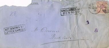
Document - CONNELLY, TATCHELL, DUNLOP COLLECTION: DOCUMENT
Three empty unclaimed letter envelopes and one buff coloured returned Letter envelope, postmarked My 4 91. Other letters to Mr. Downie, Back Creek My 4 94; Mr. W. Donohue, Echuca, Ja 24 94; Mrs. Crawford, Myrtle Creek, Jy 4 98.business, legal, connelly & tatchell, connelly & tatchell collection - document, mrs crawford, mr w donohue, mr downie, connelly & tatchell -
 Bendigo Historical Society Inc.
Map - CALIVIL : COUNTY OF BENDIGO, 12-12-22
Map. Calivil, County of Bendigo, Mologa, Jarklan, Pompapiel, Talambe, Hayanmi. Calivil Creek, Seven Months Creek. Photo-Lithographed at the Department of Lands and Survey, Melbourne by W.J. Butson,12-12-22, Price 1/-. By authority A.J. Mullett, Government Printer, Melbourne. (number 56 in map cupboard 1)A.J. Mullett, Government Printer, Melbourne.map, bendigo, calivil -
Bendigo Historical Society Inc.
Map - EGERTON : COUNTY OF BENDIGO, 29-5-23
Map. Egerton, County of Bendigo, Minto, Giggorra, Elmore, Nolan, Goornong, Bagshot, Whirrakee, Bendigo Creek, Round Creek. By authority A.J. Mullett, Government Printer, Melbourne.Photo-Lithographed at the Department of Lands and Survey, Melbourne by W.J. Butson, 29-5-23. Price 1/-. (number 48 in map cupboard 1)A.J. Mullett, Government Printer, Melbourne.map, bendigo, egerton -
Southern Sherbrooke Historical Society Inc.
Information folder - Dandenong Ranges Steiner School, 2007
Information folder containing items pertaining to the Dandenong Ranges Steiner School, Menzies Creek & Lysterfield. Contents:/- typescript, "The Dandenong Ranges Steiner School", a brief history of the school written by Louise Reidsimmons for Lisa Hall's update of Menzies Creek Primary School's centenary book, n.d. but c. 2007, one sheet."For Lisa Hall" written in blue ink at top of pagedandenong ranges steiner school, menzies creek hall, menzies creek shop, melbourne water buildings, cardinia reservoir -
 Marysville & District Historical Society
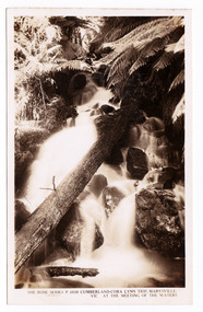
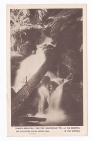
Postcard (item) - Black and white postcard, Rose Stereograph Company, Cumberland-Cora Lynn Trip, Marysville, Vic. At the Meeting of the Waters, 1913-1967
A postcard in a series produced by the Rose Stereograph Company in Victoria, Australia as a souvenir of Marysville.A black and white photograph of the Cora-Lynn waterfall at the Meeting of the Waters near the Cumberland Creek. The Whitehouse Creek joins the Taggerty River at the Meeting of the Waters which is near The Beeches Rainforest Walk. The ancient rainforest features groves of Myrtle Beech trees (Nothofagus cunninghamii) with many trees over 300 years old. POST CARD The "Rose" Series/ De Luxe A Real Photograph/ Produced in Australia Published by the Rose Stereograph Co.,/ Armadale, Victoria.cora lynn falls, waterfalls, cumberland valley, cumberland creek, marysville, victoria, p. 4938, rose series postcard, postcard, souvenir, the beeches, nothofagus cunninghamii, whitehouse creek, taggerty river -
Glenelg Shire Council Cultural Collection
Photograph - Photograph - Wooden Bridge, n.d
Sourced from Casterton Town Hall (Former Shire of Glenelg)Coloured photograph. Wooden bridge, close-up of wooden rails on one side. Erosion of creek banks can be seen in background. -
Glenelg Shire Council Cultural Collection
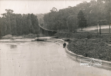
Negative - Negative - Gardens and Salt Creek Portland, Victoria, c. 1934
Negative for a black and white photograph. Image shows Portland, Victoria Gardens on right, Salt Creek, dirt road and footpath in foreground. -
 Halls Gap & Grampians Historical Society
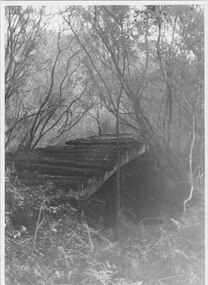
Photograph - B/W
Photo shows old rail bridge, surrounded by bush & passing over what appears to be a creek. Bridge is supported by wooden trestles. structures, bridges -
 Halls Gap & Grampians Historical Society
Photograph - B/W, C 1940s (?)
Photo shows an unsealed section of Grampians Rd. near Jimmy's Creek. The sharp profile of Mt Frederick can be seen in the distance.access routes, roads -
 Eltham District Historical Society Inc
Photograph, George W. Bell, Looking towards trestle bridge from new Shire Hall, 1965c
Black and white photograph looking west to railway bridge over Diamond Creek from Shire Office carpark c.1965.bridges, railways, eltham, diamond creek, eltham shire office, george w bell collection -
 Victoria Police Museum
Carte de Visite (re-enactment of shoot-out), A.W. Burman
Small black and white photograph in a bush setting showing a re-enactment of the shoot-out between Kelly and the police at Stringybark Creekkelly gang, ned kelly, edward kelly, stringybark creek, police murders, murders -
 Ringwood and District Historical Society
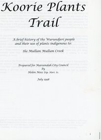
Book, Koori Plants Trail, 1998
Brief History of the Wurundjeri people and the use of plants indigenous to the Mullum Mullum Creek prepared for Maroondah City Council - July 1998 -
 Marysville & District Historical Society
Postcard (item) - Black and white postcard, Rose Stereograph Company, Cumberland-Cora Lynn Trip, Marysville, Vic. At the Meeting of the Waters, 1913-1967
A postcard in a series produced by the Rose Stereograph Company in Victoria, Australia as a souvenir of Marysville.A black and white photograph of the Cora-Lynn waterfall at the Meeting of the Waters near the Cumberland Creek. The Whitehouse Creek joins the Taggerty River at the Meeting of the Waters which is near The Beeches Rainforest Walk. The ancient rainforest features groves of Myrtle Beech trees (Nothofagus cunninghamii) with many trees over 300 years old. POST CARD Correspondence Addresscora lynn falls, waterfalls, cumberland valley, cumberland creek, marysville, victoria, postcard, souvenir, the beeches, nothofagus cunninghamii, whitehouse creek, taggerty river, southern cross series, 4938 -
Bendigo Historical Society Inc.
Photograph - SANDHURST CITY BATHS 1884, 1884
Laminated copy of a photograph of Sandhurst City Baths 1884 Baths were located in current Bath Lane beside the Bendigo Creek.bendigo, entertainment, swimming pool -
 Bendigo Historical Society Inc.
Book - THE EARLY DAYS OF THE WOOLSHED, 1988
The Early Days of the Woolshed. A history of the early days of Woolshed, Reid's Creek, and Sebastopol of the owners of the Ovens Goldfield, North Eastern Victoria.G. F. Craiggoldfields, gold woolshed, reid's creek, sebpol -
 Bendigo Historical Society Inc.
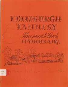
Book - EDINBURGH TANNERY - SHEEPWASH CREEK, 1981
Edinburgh Tannery - Sheepwash Creek, Mandurang. The story of the Hon. J. H. Abbott, MLC, J.P. Compiled by W. B. Kimberly.Compiled by W. B. Kimberly.autobiography, life and businesses of , . h. abbot -
Port Melbourne Historical & Preservation Society
Map - Footscray, Public Lands Office, 19 Oct 1857
Map of Footscray, west of Saltwater Creek; south of Hopkins Street, east of Railway and north southern boundary of Botanical Garden reserve.The Township of Footscray, Parish of Cut-Paw-Pawfootscray -
Bendigo Historical Society Inc.
Map - LOCKWOOD, November 25th 1855
Map: Garden Allotments within the Town Reserve of Lockwood on the Bullock Creek. Parish plan (number 273 in map cupboard 1)map, bendigo, parish plan, lockwood, garden allotments, bullock creek -
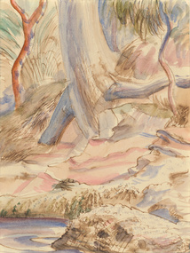 Benalla Art Gallery
Watercolour, Eric WILSON, Berowra, 1940
Born: Annandale, New South Wales, Australia 1911; Lived and worked: England and France 1937-1940; Died: Sydney, New South Wales, Australia 1946ModernismGift of Mrs E.E. Ledger, 1987Watercolour depicting a creek bed with rock in the foreground. Unframed, hinged taped with two pieces of white tape to cream mat boardRecto: Not signed, not dated, not titledwatercolour, landscape, trees, water, rock, roots -
Clunes Museum
Textile - MANCHESTER ANTIMACASSAR
2 HAND MADE CLOTH RIBBON, CROCHET IN CENTRE AND ALCE EDGING. MADE BY LOUISE MCCUBBIN, COGHILLS CREEK C 1880antimacassar, manchester, louise mccubbin -
 Clunes Museum
Photograph
THEO HARDEN, FRANK COLLINS & HARRY TOOLE AT THE OPENINGOF THE SUSPENSION BRIDGE OVER CRESWICK CREEK, CLUNES. 14/4/1986local history, photography, photographs, bridges -
Whitehorse Historical Society Inc.
Map, City of Nunawading, 1/02/1973 12:00:00 AM
Map of City of Nunawading shoeing open creeks or watercourses and watercourses that have been piped.Map of City of Nunawading shoeing open creeks or watercourses and watercourses that have been piped. Scale: 800 feet =1 inchMap of City of Nunawading shoeing open creeks or watercourses and watercourses that have been piped. blackburn, blackburn north, blackburn south, burwood east, forest hill, mitcham, nunawading, vermont, vermont south, city of nunawading, creeks -
Whitehorse Historical Society Inc.
Article, Cross Over Bridge, 2016
Community opinions on the Deakin University proposed bridge over Gardiners Creek Reserve.Community opinions on the Deakin University proposed bridge over Gardiners Creek Reserve that will link the two halves of its Burwood campus.Community opinions on the Deakin University proposed bridge over Gardiners Creek Reserve.deakin university, gardiners creek reserve, burke, anna, wynne, richard -
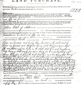 Whitehorse Historical Society Inc.
Legal record - Land Title, Land Purchase, 2/02/1858
Photocopy of agreement for land purchase by auction held on 2 February 1858.Photocopy of agreement for land purchase by auction held on 2 February 1858. Purchase by Nelson Polak of land adjacent to Dandenong Creek.Photocopy of agreement for land purchase by auction held on 2 February 1858. polak, nelson, dandenong creek, land sales -
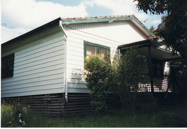 Whitehorse Historical Society Inc.
Photograph, Schwerkolt House, 1/11/1999 12:00:00 AM
Weatherboard Home painted cream & green built for Francesca Schwerkolt C.1960's. 27 Deep Creek Road, Mitcham.schwerkolt, francesca, deep creek road, mitcham, no. 27 -
![Photograph - Black and White, John Joseph Gervasoni and [Jim Mallim?], c1930](/media/collectors/57a00a4fd0cdd1210422a51e/items/59c4afc521ea7113f4f53694/item-media/59c4afcf21ea7113f4f53b14/item-fit-380x285.jpg) Ballarat Heritage Services
Ballarat Heritage ServicesPhotograph - Black and White, John Joseph Gervasoni and [Jim Mallim?], c1930
Two men stand in front of an a deHavilland DH-60 Moth aeroplane. John Joseph Gervasoni of Yandoit Creek stands on the right.flight, aeroplane, biplane, john joseph gervasoni, a dehavilland dh-60 moth -
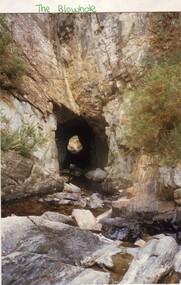 Ballarat Heritage Services
Photograph - Photograph - Colour, L.J. Gervasoni, Blowhole, Hepburn Springs, 1987, 1987
Colour photograph of a view through a blast hole made through basalt at Hepburn by Chinese Miners to divert the Jim Crow Creek.blowhole, hepburn, chinese, jim crow creek -
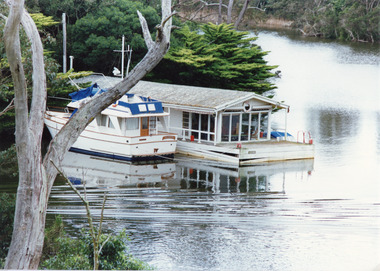 Lakes Entrance Regional Historical Society (operating as Lakes Entrance History Centre & Museum)
Photograph, Tambo Shire, 1994
Also second identical copyColour photograph of a holiday house, built over the water at Box's Creek, a motor cruiser moored beside the house. Metung Victoriawaterways, transport -
Southern Sherbrooke Historical Society Inc.
Typescript, "Life In Emerald From 1896 -1969", 1969
Original typescript written by G. Douglas c.1969. Carbon copy held by Helen Gibson and transcribed in 1990s.Transcribed typescript of short history of Menzies Creek area written by Gerald Douglas, in A4 display folder, 6 pages and map.menzies creek, emerald, nobelius nursery, douglas family, st. cuthbert's church, willis family