Showing 7077 items
matching snowy-river
-
 Tatura Irrigation & Wartime Camps Museum
Booklet, The State of the Rivers, 1983
Produced to present an overall review of the state of our riversCream cover, bushland scene, mist above small waterfallvictorian rivers, tatura, river catchment problems, irrigation, documents, reports -
Malmsbury Historical Society
Photograph (Item), Burning Off After Clean Up, Malmsbury ca2003
Buildings - Coliban River People - "Tynan, Alexandra (Photographer)" -
Malmsbury Historical Society
Photograph (Item), Landscape Malmsbury, Malmsbury ca2003
Buildings - Coliban River People - "Tynan, Alexandra (Photographer)" -
 Malmsbury Historical Society
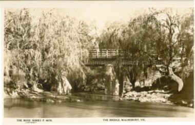
Postcard (Item), "Postcard Bridge At Malmsbury, Rose Series P4676", Malmsbury c1927
Associated with - Rose Series P4676 Buildings - Coliban River -
 Malmsbury Historical Society
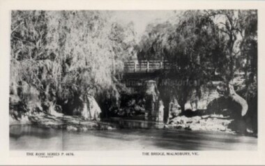
Postcard (Item), "Postcard Bridge At Malmsbury, Rose Series P4676", Malmsbury c1930
Associated with - Rose Series P4676 Buildings - Coliban River -
 Mont De Lancey
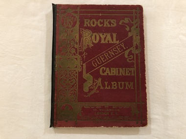
Book, Rock's Royal Guernsey. Cabinet Album
Mrs Liddy, 59 River Street, Maidstone, VictoriaA maroon covered album containing Postcard scenes of Guernsey. Printed in Germany. The title is embossed in gold lettering and pattern on the front cover with a black spine binding.albums, books, photographs, guernsey -
 Eltham District Historical Society Inc
Photograph, Fay Bridge, Ruins of the old Warrandyte Battery, 7 November 2016
Remains of the timber foundation of the State Battery, built here in 1897 can be seen on the banks of the Yarra River just east of the Warrandyte Bridge on the Warrandyte side of the river. The Battery was driven by waterwheel and was used to crush ore from the Warrandyte Goldfields.fay bridge collection, 2016-11-07, warrandyte battery, ruins -
 Bendigo Historical Society Inc.
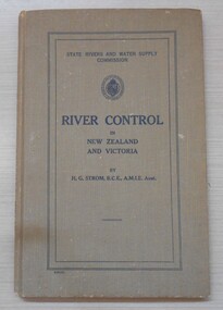
Book - River Control in New Zealand and Victoria, 1941
This book was commissioned by the State Rivers and Water Supply Commission on the recommendation of Frank E. Old, Minister of Water Supply to meet the need for a comprehensive and progressive policy of river improvement. This book was presented to Milton King, the father of the donor Neville King.Khaki coloured hard cover book. 131 pp. Black and white illustrations and diagrams. Author H.G.Strom, BCE, AMIE. Australia. Neville King CollectionM R King 29/08/41 written in pencil inside the front cover.water supply, rivers, h g strom -
 Bendigo Historical Society Inc.
Photograph - BENDIGO HISTORICAL SOCIETY COLLECTION: KENNEDY'S OLD STABLE BUILDING , BARNADOWN
Colour photograph of Kennedy's old stables, Barnadown, situated near the Burke and Wills Memorial site. Shed has timber uprights and iron roof, no cladding on the walls. Large trees behind. Property is situated near the Campaspe River.agriculture, farm, kennedy's woolshed -
Port Melbourne Historical & Preservation Society
Photograph - Double-sided aerial photograph, Hobson's Bay and the Yarra River/Port Phillip and Western Port Bay, Surveyor General and Director of Mapping, Apr 1990
Landsat imagery - an extract from the atlas of VictoriaAerial photos of Port Phillip and Western Port (double sided aerial photographs). 1995 side A: Hobson's Bay and Yarra River - aerial photo mosaic; side B. Port Phillip and Western Port Bays - satellite photo.port of melbourne authority -
Port Melbourne Historical & Preservation Society
Photograph - Nairana, 15 Jan 1942
"Nairana" probably in the Derwent River (?). Turbine vessel built just before WWI and commandeered by British Government as an aircraft carrier. Later ferry to Tasmania and went around west of Station Pier, came to Australia c 1920/21.maritime, transport - shipping, nairana -
 El Dorado Museum Association Inc.
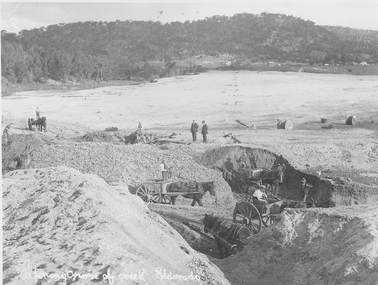
Photograph (item) - Digital Image
Altering course of Reedy Creek, El Dorado. Cocks Pioneer Electric Gold & Tin Mine Company was formed in 1899. The company's first power station, located at the eastern end of the valley began operating with its 340 Kilowatt steam-powered generator. By 1909, from 2,500,000 cubic yards worked, reported recovery was 17,284 ounces of gold and 224 tons of tin ore. By 1909, Cocks Pioneer’s power plant had become inadequate and uneconomical. The barge was floated downstream about a mile, but lost time caused the operations to cease. Following testing, a new mine was established by diverting Reid's Creek at a cost of £25 000. Settling dams were built, one of which held 1,935,900 cubic feet. Sold earth banks, built against a wall of stringy bark saplings constructed and laced with vertical props, were built. In 1914, the company was reformed as Cock’s Pioneer Gold and Tin Mines NL, another power station was constructed at the western end of the township, near the junction of Clear and Reid's Creeks. From 6,800,000 cubic yards of material processed, the returns were 64,397 ounces of gold and 855 ton of tin. Cocks Pioneer mine then moved the barge downs stream and continued sluicing. In 1929 Cocks Pioneer Electric Gold and Tin Mining Company ceased operations due to a drop in values. Cock’s Pioneer Gold and Tin Mines NL carried on large-scale hydraulic sluicing operations until 1941. Handwritten across the front: 'Altering course of creek. Eldorado'mining, gold, tin, sluicing, reedy creek, cocks pioneer, el dorado, eldorado, men, horses -
 Victorian Aboriginal Corporation for Languages
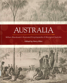
Book, Harry Allen, Australia : William Blandowski's illustrated encyclopaedia of Aboriginal Australia, 2010
William Blandowski was an explorer, natural scientist and artist who led a Victorian government expedition to the junction of the Murray and Darling Rivers from 1856 to 1857. This is the first publication in English of his nineteenth century illustrated encyclopaedia of Aboriginal life.Maps, b&w illustrationsaboriginal australian history, pictorial histories, william blandowski -
Victorian Aboriginal Corporation for Languages
Book, Harry Allen, Australia : William Blandowski's illustrated encyclopaedia of Aboriginal Australia, 2010
William Blandowski was an explorer, natural scientist and artist who led a Victorian government expedition to the junction of the Murray and Darling Rivers from 1856 to 1857. This is the first publication in English of his nineteenth century illustrated encyclopaedia of Aboriginal life.b&w illustrations, mapswilliam blandowski, pictorial works -
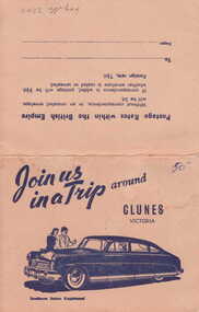 Clunes Museum
Photograph
PICTURESQUE SOUVENIR OF CLUNES. A FOLDER OF 8 PHOTOS CONSISTING OF VIEWS OF CLUNES 1. 4 PANORAMAS 2. CLUNES HOSPITAL 3. OLD POST OFFICE 4. TALLAROOP RIVER CLUNES 5. 2 OF FRASER STREET, CLUNESJOIN US IN A TRIP AROUND CLUNESlocal history, photography, photographs, township & buildings -
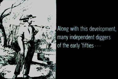 Bendigo Historical Society Inc.
Slide - DIGGERS & MINING. DIGGERS AND MINERS, c1850s
Diggers & Mining. Diggers and miners. Along with this development, many independent diggers of the early 'fifties' - - - Slide shows a miner caring a shovel and a rope. A cradle by the river in the background. Markings: 30 994:LIF I. Used as a teaching aid.hanimounteducation, tertiary, goldfields -
 Kew Historical Society Inc
Map, Robert Russell, Map Shewing the Site of Melbourne and the Position of the Huts & Buildings Previous to the Foundation of the Township by Sir Richard Bourke in 1837
Map shows the first layout of Melbourne by Government surveyor Robert Russell, who accompanied Governor Richard Bourke in 1837. The surveyed blocks extend from present-day Flinders Street to Lonsdale Street, and Spring Street to Spencer Street, with extensive vacant land west to a salt lake (afterwards Batman's Swamp, later drained), north beyond Flagstaff Hill and south towards South Melbourne. Vegetation coverage is indicated, and tracks and existing buildings and cultivated land are shown.Printed map was created by Day & Haghe, Lithographers to the Queen, sometime after 1838, when the company received its Royal appointment. Copies of the 1837 map exist in several major map collections in Australia; most are uncoloured. This particular map is the earliest in the Kew Historical Society's map collection. It is a nationally significant artefact. Black and white lithographed map hand-coloured in blue and yellow gouache of the town of Melbourne in 1837. In contrast to the original lithograph, the river and the township blocks are coloured blue and yellow. A similar, partly coloured copy is in the collection of the University of Melbourne.maps - melbourne - 1830s, governor sir richard bourke, robert russell - surveyor, cartography -
Beechworth Honey Archive
Map- Albury/Wodonga
(5x) Map centred on Albury and Wodonga. Shows Albury and Wodonga, Murray River, Hume Highway, Murray Valley Highway and Riverina Highway. Scale 1:50,000. Paper is white on back and yellow on front. Ca 1974-1975 Labelled 'Albury series R 652'map, albury, wodonga, paper, beechworth honey -
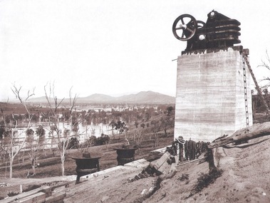 Wodonga & District Historical Society Inc
Album - Hume Reservoir Australia Album - Quarry plant being erected September 1921
This set of photos is from a leather bound album bearing the inscription "HUME RESERVOIR AUSTRALIA" plus 'The Rt. Hon. L. C. M. S. Amery, P. C., M .P.' all inscribed in gold. It was presented to The Rt. Hon. L. C. M. S. Amery, P. C., M. P, Secretary of State for Dominion Affairs on the occasion of his visit to the Hume Reservoir on 2nd November 1927. This album is of local and national significance as it documents the planning and development of the Hume Reservoir up to 1927. It was the largest water reservoir in the British Empire. The album records the pioneering engineering work that went into its construction.DEPARTMENT OF PUBLIC WORKS, N.S.W. RIVER MURRAY WATERS SCHEME. HUME RESERVOIR. 7. Quarry plant (New South Wales) being erected, September 1921. Murray Flats (in foreground) and Mitta Mitta Flats (beyond) flooded.hume reservoir australia, river murray waters scheme, quarry plant hume -
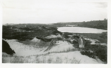 Lakes Entrance Historical Society
Photograph, 1950c
Also enlargement 15x25cmBlack and white photograph of the Warm Holes, from the sand hummocks looking west. The Warm Holes are the remnant of Reeves River, the original waterway from the Gippsland lakes to the natural entrance. Lady with shawl in foreground. Lakes Entrance Victoria waterways, topography -
 Lakes Entrance Historical Society
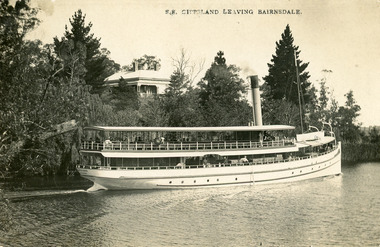
Postcard - S.S. Gippsland, Segerberg and Bulmer, 1909
S S Gippsland was launched at Paynesville 1908. Letter on back mentioning 'Our New Boat'Black and white postcard print showing S S Gippsland in Mitchell river at Bairnsdale, shows three pine trees, large house vegetation on eastern bank, ship leaving Bairnsdale newly painted. Lakes Entrance VictoriaS.S. Gippsland Leaving Bairnsdalevegetation, waterways, ships and shipping, houses -
 Lakes Entrance Historical Society
Photograph - Foreshore Lakes Entrance, Bulmer H D, 1923c
Second copyBlack and white photograph showing aerial view of the entrance to the Gippsland Lakes, shows Cunninghame Arm, North Arm, Reeves River and Hopetoun Channel, Rigby Island and Snake Island, the barrier on right foreground. Lakes Entrance Victoriawaterways, islands, aerial photograph, fishing industry, coast -
 Lakes Entrance Historical Society
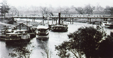
Photograph - Bairnsdale Wharf, 1911
Black and white photograph showing P S Tanjil, S S Gippsland and dredge Pioneer at Bairnsdale wharf, steamer J C D at opposite bank. Early road bridge across Mitchell River. Bairnsdale Victoriaships and shipping, waterways, wharfs, bridges -
 Bendigo Historical Society Inc.
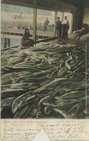
Postcard - Alice McGregor Postcard Collection, 1900 - 1920
Alice McGREGOR Born: 1908; unknown parents. Possibly adopted by the Salter family? Electoral Roll 1936: Highland Terrace Kangaroo Flat. Alice Mary Salter and William Robert Salter living together; presumed to be sister and brother. William Robert Salter was killed in a MVA in Bendigo in 1937 aged 26. In Victoria in 1938, Alice Mary Salter married James Thomas McGregor (born Victoria 1917, died Victoria 1983, buried Fawkner Cemetery) Lived: 1968; 22 Wade Street Golden Square Alice McGregor Died: 1999 aged 91 at Anne Caudle Centre, Bendigo Buried: Kangaroo Flat Cemetery See additional research. Postcard Album of Alice McGregor contained 86 post cards.Postcard Album of Alice McGregor containing 86 post cards. See 1400 Colour image of fish on Cannery Wharf, Fraser River, British Columbia, Canada 4 people overlooking a vast pile of fish. Wharf in background Addressed to Miss A. Stapleton, Arcade, Bendigo, Victoria, Australia Sender - Harold Nation, Cranbrook, British Columbia, Canada dated Oct 2 '05 postcard, collector, alice mcgregor -
 Melbourne Tram Museum
Negative, Wal Jack, 10/02/1941 12:00:00 AM
Black and white negative, by Wal Jack, of No.Y1 611 inbound in Swan St Richmond or Burnley after crossing the Yarra River bridge. Photo dated 10-2-1941 in the Wal Jack album along with details of the location.trams, tramways, swan st, y1 class, burnley, tram 611 -
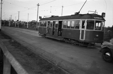 Melbourne Tram Museum
Negative, Wal Jack, 1/09/1941 12:00:00 AM
Black and white negative, by Wal Jack, of CW5 681, (Burwood, Route 74) in Swan St Burnley, prior to crossing the Yarra River. Photo dated 1-9-1941 in the Wal Jack album along with details of the location.trams, tramways, burnley, cw5 class, swan st, route 74, tram 681 -
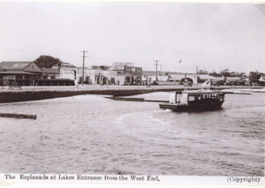 Lakes Entrance Historical Society
Photograph - MV Blackbird, H D Bulmer, Peels tourist launch Blackbird, Lakes Entrance Victoria, 1940 c
Black and white photograph of postcard of Peels tourist launch Blackbird in Cunninghame Arm opposite Kia Ora House Lakes Entrance Victoria. Also a black and white photograph of Peels launch Blackbird in the Tambo River East GippslandThe Esplanade at Lakes Entrance from the West Endtourism, boats and boating -
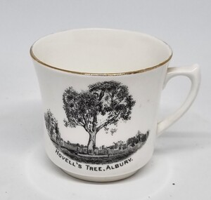 Wodonga & District Historical Society Inc
Souvenir - Cup Hovell's Tree, Albury
This souvenir represents the Hovell Tree, a local historic landmark in Albury, NSW. This item is from a collection donated by descendants of John Francis Turner of Wodonga. The Hovell Tree commemorates the exploration and naming of the Hume River (now the Murray) by Hume and Hovell`s expedition of 1824. In 1824, Governor Brisbane asked Hume to join forces with an English sea captain, William Hovell, to go from Lake George to the Spencer Gulf in South Australia. The Hovell Tree, marked by William Hovell on November 17, 1824 was flanked by another tree marked by Hamilton Hume which was destroyed by fire in the 1840's. The river gum was marked by William Hovell when discovering river. Hume and Hovell travelled from the Yass area and after crossing the Murray River where Lake Hume now is, they crossed the Mitta Mitta River and proceeded to Corio Bay, Westernport.This item is representative of souvenirs produced to represent key buildings and historic landmarks in the Albury-Wodonga district.A white cup with gilt trim around the lip. It bears an image of the Hovell Tree in Albury, NSWBeneath image: "HOVELL'S TREE, ALBURY."albury souvenirs, hovell tree, hume and hovell, australian exploration -
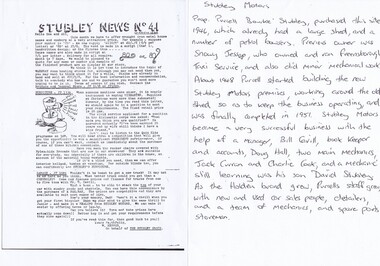 Greensborough Historical Society
Photograph - Digital Image, Stubley News and History, 1954_03
Stubley Motors Newsletter March 1954. The Stubley Group began in 1946 when Purcell Stubley purchased a site with petrol bowsers in Main Street from 'Snowy' Jessop. In 1948 Purcell began building the new Stubley Motors, working round the old site to keep the business operating. It was completed in 1951. The Group expanded into a Holden dealership in the 1960s.Digital copy of black and white newsletter, with handwritten notes on the company's history.purcell stubley, stubley motors, stubley group greensborough -
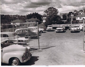 Greensborough Historical Society
Photograph - Digital Image, Stubley Garage Car Yard, 1951_
Stubley Garage car yard 1951. The Stubley Group began in 1946 when Purcell Stubley purchased a site with petrol bowsers in Main Street from 'Snowy' Jessop. In 1948 Purcell began building the new Stubley Motors, working round the old site to keep the business operating. It was completed in 1951. The Group expanded into a Holden dealership in the 1960s.Digital copy of black and white photographpurcell stubley, stubley motors, stubley group greensborough