Showing 5249 items
matching view road
-
 Ringwood and District Historical Society
Photograph, Methodist Church, Station Street, Ringwood - viewed from clock tower in 1960, 1960
Methodist Church, Station Street, Ringwood, viewed from the clock tower at Warrandyte Road in 1960Written on back of photograph, "Methodist Church from clock tower - 1960". -
 Ringwood and District Historical Society
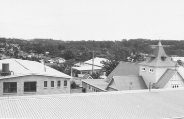
Photograph, St. Paul's Church of England, Ringwood Street, Ringwood, viewed from Town Hall in 1962, 1962
St. Paul's Church of England from Town Hall in 1962Written on back of photographs, "Town Hall roof 12/62. St. Paul's C. of E." -
 Ringwood and District Historical Society
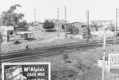
Photograph, Maroondah Highway Central, Ringwood. View of buildings on Maroondah Highway Ringwood, taken overlooking railway yard from Station St. and Greenwood Ave., 1914
Black and white photograph (2 copies)Typed below one photograph: "View of buildings on Maroondah Highway taken overlooking railway yard from Station St. and Greenwood Ave. 1914". Written on rear of backing sheet: "View of township taken from near the Methodist Church showing railway yards, Ringwood Hall and Methodist Church Hall. Methodist Church closed 1915. Photo taken from new one (Cnr. Greenwood Ave.)". -
 Ringwood and District Historical Society
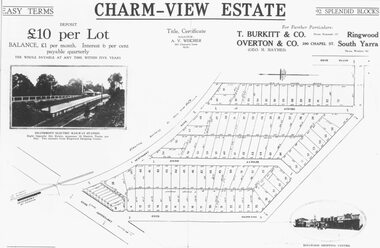
Photograph, Land sale advertisement for Charm View Estate, Heathmont - 1927
Map - Charm-View EstateTyped below photograph, "From 1927 land subdivision brochure". -
 Ringwood and District Historical Society
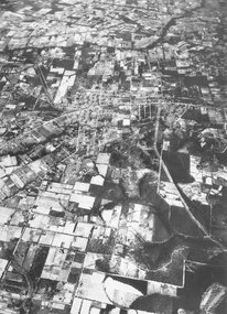
Photograph, Aerial view of Park Orchards and Ringwood - c.1960
Catalogue card reads, "Aerial view of Ringwood". -
 Ringwood and District Historical Society
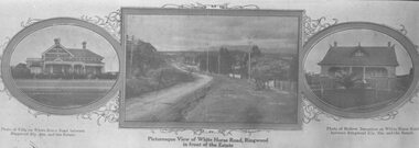
Photograph, Strip of images used for Ringwood Heights Estate land sale promotion - 1924
Strip of 3 views apparently part of a land sale advertisement - View of Whitehorse Rd between photos of two Whitehorse Rd houses.Typed on back of photographs, "Ringwood Heights Estate. Land on left of road and down to Mullum Creek. Sold by T. Grant. 97 lots, 1st March 1924. J.B. McAlpin, agent. No deposit, 1 pound per month." -
 Ringwood and District Historical Society
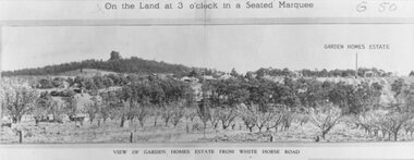
Photograph, Image used for land auction promotion of Garden Homes Estate between Mullum Mullum Road, Ringwood and Mullum Mullum Creek - 20/10/1923 , later developed to include The Centreway, Wattle Crescent, and Reserve Crescent, Ringwood
Black and white photograph of picture from subdivisional brochure. Picture shows orchard in foreground with a hill towards background. Treed area in the middle with a few houses scattered amongst them. To right of picture is printed, "Garden Homes Estate" with an arrow pointing to land. Printed above picture, "On the Land at 3 o'clock in a Seated Marquee. Typed below picture, "View of Gard -
 Ringwood and District Historical Society
Photograph, View from Ringwood Civic Centre. East Ringwood oval can just be seen - 1973
Typed below photograph, "A view from Ringwood Civic Centre. East Ringwood oval can just be seen - 1973." -
 Ringwood and District Historical Society
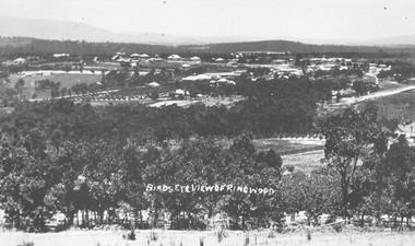
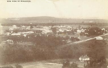
Photograph, Birds eye view of Ringwood 1912
Written onto photograph, "Birds eye view of Ringwood". Small photograph notes that photograph was taken in 1912 and that is shows the brickworks and Reimers house in Warrandyte Rd. -
 Ringwood and District Historical Society
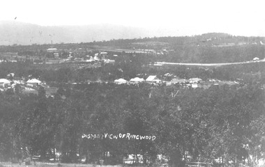
Photograph, Distant view of Ringwood from Loughnans Hill - 1912
Typed below photograph, "Distant view of Ringwood from Loughnans Hill - 1912. Big building top left with chimney is brickworks, in centre is old Catholic Church, Club Hotel, Big road top right is Maroondah Highway." -
 Ringwood and District Historical Society
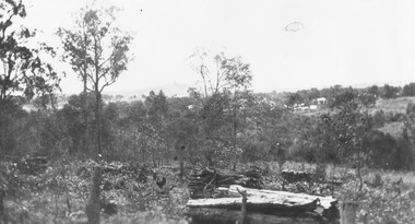
Photograph, View from Herman Pump's orchard, Heathmont near Royal Avenue. Looking towards Bedford Rd. and Ringwood (undated)
Typed below photograph, "View from Herman Pump's orchard, Heathmont near Royal Avenue. Looking towards Bedford Rd. and Ringwood. Loughnans Hill in background to left of centre." -
 Ringwood and District Historical Society
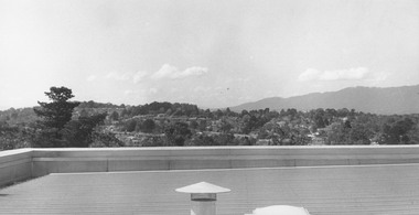
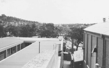
Photograph, View from Civic Centre roof - September 1973
Written on backing sheet, "From Civic Centre roof - September 1973". -
 Ringwood and District Historical Society
Photograph, View from Colemans Estate Heathmont, 1923. Near corner of Bedford and Canterbury Roads
... Road Ringwood North melbourne Typed below photograph, "View ...Typed below photograph, "View from Colemans Estate Heathmont, 1923. Near corner of Bedford and Canterbury Roads". -
 Ringwood and District Historical Society
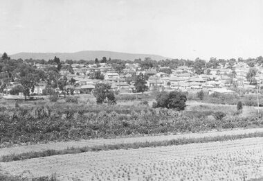
Photograph, View over Ringwood from Mullum Road, 1960
Typed below photograph, "View over Ringwood from Mullum Road, 1960" but small original photograph states photograph was taken in 1959. -
 Ringwood and District Historical Society
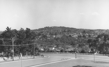
Photograph, View from Civic Centre, Braeside Avenue, overlooking Maroondah Highway towards Loughnan's Hill - 1973
Black and white photograph looking towards T-intersection towards housing and trees on hill. -
 Ringwood and District Historical Society
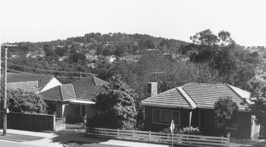
Photograph, View from Maroondah Highway opposite Braeside Avenue towards Loughnan's Hill - 1973
... Road Ringwood North melbourne View from Maroondah Highway ...View from Maroondah Highway opposite Braeside Avenue towards Loughnan's Hill - 1973. -
 Ringwood and District Historical Society
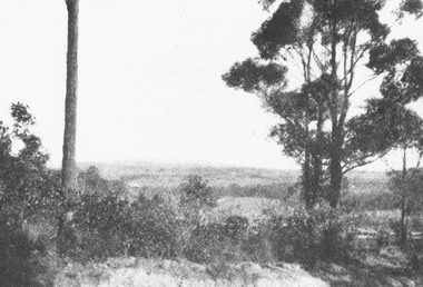
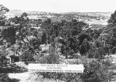
Photograph, Two images of view from Pinemont Estate, Loughnans Hill, looking east, c1930
Black and white photograph of view. Trees and bushes in foreground, orchards and mountains towards background. (2 copies)Typed on photograph, "Pinemont Estate, Ringwood. View Dandenong Ranges, from estate". Typed below photograph, "View from Loughnans Hill, looking east, c1930. Club Hotel can just be seen top right corner". -
 Ringwood and District Historical Society
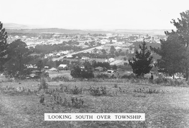
Photograph, Looking south over Ringwood township from Loughnans Hill c1930. Ringwood Street is the main road in the centre
Black and white photograph taken from hill overlooking township of Ringwood. (3 copies)Printed on photograph, "Looking south over township". Typed below photograph, "View from Loughnans Hill c1930. Ringwood Street is the main road in the centre. Old St. Pauls, railway crossing, Methodist church, state school, coolstores, etc. can all be seen". -
 Ringwood and District Historical Society
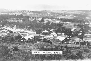
Photograph, View from Loughnan's Hill looking east c1930
Black and white photograph taken from vacant land on hill. Scene overlooks housing and trees. Mountains in background. (2 copies)Typed on photograph, "View looking east". Typed below photograph, "View from Loughnans Hill c1930. Maroondah Highway, Catholic church all top right corner". -
 Ringwood and District Historical Society
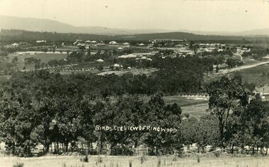
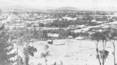
Photograph, Overlooking Ringwood from Loughnans Hill showing the antimony mine and brick works c.1914
Two postcards, same view but different reverse sides. One was made by "Empire" with a 1d postage (see description below); the other with "JB McAlpin, Estate and Financial Agent, District Government Valuer, Ringwood". A letter on one of the postcards is dated 1914 and is addressed to "Mrs. F. Palmer, c/- Mrs. E. F. Tregaskis, White Horse Road, Ringwood, via Melbourne". The letter is to her mother and the daughter's name is "Eveline". The following is written on the back of one of the enlargements, "View of Ringwood East taken from Loughnans Hill showing the antimony mine and brick works. Houses across centre are in Warrandyte Road. -
 Ringwood and District Historical Society
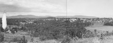
Photograph, Panoramic view of Ringwood taken from the home of Dr. Geoffrey A. Cook, Loughnan Rd., Ringwood. (No date)
Written on back of photograph, "Panoramic view of Ringwood taken from the home of Dr. Geoffrey A. Cook, Loughnan Rd., Ringwood. See booklet, 'Welcome to Ringwood' 1948 or 49' - H.J. Pearson Mayor". -
 Ringwood and District Historical Society
Photograph, View of Ringwood in 1912 taken from Loughnan's Hill
... Street. Warrandyte Road is above it." View of Ringwood in 1912 ...Black and white photograph looking across valley with small settlement. Mountains in background. (2 postcard copies and 2 enlargements). House in right foreground is in what is known now as Wildwood Grove. The dirt track above is Ringwood St. Field above is the football field with diagonal track coming out at Melbourne Street, later Eastland shopping complex. House on left is in Adelaide Street. Warrandyte Road is above it."Typed on back of one enlargement, "Copied from a postcard mailed in Ringwood, 1912, copied 1959. House in right foreground is in what is known now as Wildwood Grove. The dirt track above is Ringwood St. Field above is the present football field with diagonal track coming out at Melbourne Street. House on left is in Adelaide Street. Warrandyte Road is above it." House bottom RH side was still there in 1970 in Wildwood Grove (off Ringwood St). Ringwood Street lower centre to RH side. Field above Ringwood Street is the football field with diag. walk coming out at Melbourne Street. House on LH side in Adelaide Street. Warrandyte above it. Steam at LH from Bently's Steam Joinery at corner Main Street and Warrandyte Road. -
 Ringwood and District Historical Society
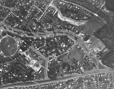
Photograph, Aerial view showing East Ringwood oval, Mount Dandenong Road, and Civic Centre, Braeside Avenue/Maroondah Hwy, c.1970
Aerial view showing East Ringwood oval, Mount Dandenong Road, and Civic Centre, Braeside Avenue/Maroondah Hwy, c.1970. -
 Ringwood and District Historical Society
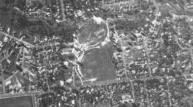
Photograph, Aerial view showing Mullum Ovals 1 and 2, Mullum Road. c.1970
... Road Ringwood North melbourne Aerial view showing Mullum Ovals ...Aerial view showing Mullum Ovals 1 and 2, Mullum Road. c.1970. -
 Ringwood and District Historical Society
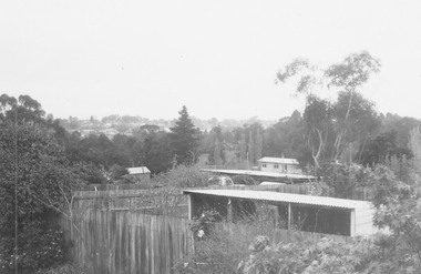
Photograph, New housing developments, New Street, 1960 viewed from railway line near Madden Street looking south-east
Written on back of photograph, "New housing settlement New Street, 1960. From railway line near Madden Street looking south-east. Dam centre foreground". -
 Ringwood and District Historical Society
Photograph, A panorama of Ringwood from Mountain View Estate, Loughnan's Hill. (no date)
Typed below photograph, "A Panorama of Ringwood" and written on back of photograph, "Mountain View estate circular". -
 Ringwood and District Historical Society
Photograph, View of the Dandenongs from Loughnan Hill (no date)
Catalogue card reads, "View of the Dandenongs from Loughnan Hill". -
 Ringwood and District Historical Society
Photograph, View from town hall roof over reserve, 1962
Catalogue card reads, "View from town hall roof over reserve, 1962". -
 Ringwood and District Historical Society
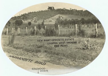
Photograph, Promotional photograph - View opposite Ringwood Estate, Warrandyte Road, looking west towards Pine Mont. (no date)
Printing on photograph reads, "View right opposite estate looking west, showing Pine Mont. Warrandyte Road". Catalogue card reads, "Pinemont Estate (Loughnan's Hill). Right opposite estate looking west." -
 Ringwood and District Historical Society
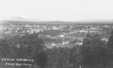
Photograph, View of Ringwood from Pinemont (no date)
Writing on photograph reads, "View of Ringwood from Pinemont".