Showing 10533 items
matching lander
-
 Federation University Historical Collection
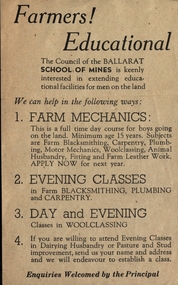
Leaflet, School of Mines Ballarat: Offer of Education for Farmers
Pamphlet offering support to "men of the Land" who wish to extend their education. Help offered with mechanics, plumbing, carpentry, blacksmithing and woolclassing, husbandry and pasture improvement. This offer was extended by the Council of The School of Mines.Light fawn paper with dark brown printballarat school of mines, education, mechanics, plumbing, carpentry, blacksmithing, woolclassing, school council -
 City of Moorabbin Historical Society (Operating the Box Cottage Museum)
Flyer - Smith's Estate, Highett
The train line from the city to Mordialloc was built which opened up the land for housing development. The section bounded by Peterson Street Telford Street and Highett Road is now Peterson Street Reserve.Example of the progress of the Municipality of MoorabbinAdvertising flyer for auction of real estate sales - plan of building blocks for saleSmith's Estate, Highett - J. F. Bradyhighett, real estate, highett road, hillside street (no longer exists), peterson st, frederico st, tolhurst st (no longer exists), wickham road, danson street, peterson street reserve -
 City of Moorabbin Historical Society (Operating the Box Cottage Museum)
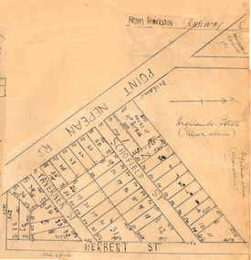
Plan - Highlands Estate, Moorabbin
The train line from the city to Frankston was electrified in 1922 which intensified the sale in the municipality of Moorabbin, particularly land which was in the vicinity of the railway stations. This estate was auctioned on Saturday, October 20, 1923.Example of the progress of the Municipality of MoorabbinAdvertising flyer for auction of real estate sales - plan of building blocks for saleHighlands Estate, Moorabbin plan.point nepean road (nepean highway), schofield street, taverner street, herbert street (now linton street), moorabbin, real estate, auction -
 Women's Art Register
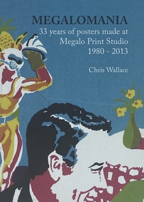
Book, Chris Wallace et al, Megalomania 35 years of posters made at Megan Print Studio 1980 - 2013, 2013
A visual record of posters made at Megalomania Print Studio, a print collective in Canberra 1980-2013Booknon-fictionA visual record of posters made at Megalomania Print Studio, a print collective in Canberra 1980-2013community, political art, artist unknown, gender, health, environment -
 Tatura Irrigation & Wartime Camps Museum
Book, Emergence of Bioregionalism in the MD Basin, 1993
An exploratory essay on he ongoing history of Murray Darling Basin includes legacies, explorations, soil erosion, irrigation divsity, land degradation, change, regionalism, conservation, maps of Vic. NSW and QueenslandGloosy cover, brown marbled scenes from Berri Irrigation Area Reiver Murray, South Australia on back. Maps, water scenes, Pyap Estates on front.murray darling basin, legacies, erosion, degradation, diversity, tatura, murray river, books, rural, industry -
Tatura Irrigation & Wartime Camps Museum
Photograph, First store and hotel, Tatura, 2001
The first store and Hotel in Tatura. T.Flanagan built his store on the land where the post and rail fence is. The frontage of the Hotel is brick. Mrs Ross conducted the business after the death of her husband.ross store, ross street, tatura, photograph, people -
 National Wool Museum
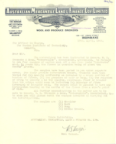
Letter
Letter from the Australian Mercantile, Land and Finance Company Limited, 1944 on behalf of their clients W.H. Treweeke and Sons of Umbercollie, Goondiwindi, Qld requesing a wool sample evaluation from W.R. Lang.wool - testing world war ii, australian mercantile land and finance company ltd, lang, dr w. roy, wool - testing, world war ii -
 Whitehorse Historical Society Inc.
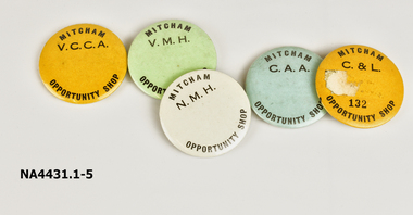
Badge - Badges, 1960s
The opportunity shop was established by volunteers to raise funds for groups as listed. The shop was in Enterprize Way, Mitcham on land once occupied by White's Hay & Corn Stores. It was a successful venture and ran for many years.Badge 1 - Opportunity Shop - Vermont - Maroondah (V.M.H.) Hospital Auxiliary (Green). Badge 2 - Opportunity Shop - Church & Life (C&L) Community Aid Abroad Badge 3 - Community Aid Abroad (C.A.A.) Opportunity Shop (Blue) Badge 4 - Opportunity Shop - Nunawading - Maroondah Hospital (N.M.H.) (White) Badge 5 - Opportunity Shop. Vermont Church Community Aid (V.C.C.) (Yellow)Mitcham Opportunity Shopnumismatics, badges -
Surrey Hills Historical Society Collection
Document, Copy of title for Lot 9C Sunbury Crescent, Surrey Hills
This house was built c1920. The Alan Holt property register records the first occupant as William H Lander, a labourer from Hallam. The property was purchased in June 1978 by Timothy O'Leary and Faye Salmon.Photocopy of title held by owners of 9 Sunbury Crescent, Surrey Hillstimothy o'leary, faye salmon, property title, 9 sunbury crescent, william h lander -
 Mont De Lancey
Coat of Arms
Coat of Arms of The Isle of Man "Whichever way I fall I land on my feet" OR another translation "Wheresoever you throw me, I will stand" From the Quayle family home. Coat of Arms of the Isle of Man. 3 legs in a circle, made of brass on leather, with a brass bucklecoats of arms -
 Wonga Park Community Cottage History Group
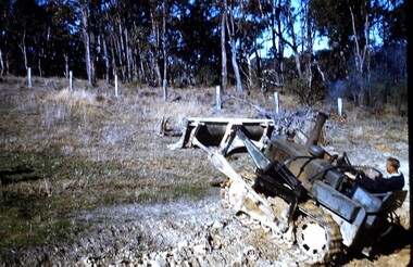
photograph, dam making, c 1940 for 1003 c1960 for 1003-1
Ernie Kear and his son Bruce were local excavators and involved in many projects around Wonga Park requiring bull dozing, in particular clearing land for orchards, building dams etcEarly history of Wonga Park orchard growing district. Early dams were built by horse and scoop on the back which was handled by the orchardist, or the dam builder but later replaced by bulldozersErnie Kear excavating a dam in Wonga Park c 1940 no hard copy electronic only -
 Orbost & District Historical Society
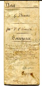
certificate, July 3, 1858
This is a certificate of indenture, a legal agreement, between George Beattie of Forest Creek, near Castlemaine in the colony of Victoria, and Peter Christian Smith of the same place. Both were miners. Beattie was the vendor and Smith paid twenty-five pounds for a land parcel. The contract was witnessed by John Hedderwick, a law clerk in Castlemaine. There is a record in the Mount Alexander Mail, dated Wed. 22 April 1857, of George Beattie purchasing land for three pounds, sixteen and sixpence in Castlemaine and that it was withdrawn. Records also show that a Peter and Thomas Smith farmed in Sandon near Castlemaine.This item is a useful research tool as it a hand-written record of part of the history of the gold fields region of Victoria.A white paper certificate of conveyance with black print and hand-written details from George Beattie to Peter Smith. There is a wax seal on the second page.beattie-george smith-peter-christian castlemaine-certificate-conveyance -
 Orbost & District Historical Society
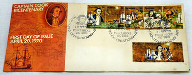
first day cover, Australia Post, April 1970
The Point Hicks cancel was used 8,269 times on the commemorative covers dated 20th April 1970. The first day cover commemorates the bicentenary of Cook's sighting of Point Hicks.When sailing along the coast of what is today southern Victoria, Cook recorded in his journal in April 1770 that he had named "The Southernmost Point of land we had in sight as Point Hicks, because Leiut Hicks, was the first who discoverd this land." This was the first European name recorded during that Endeavour voyage to be applied to a feature on the east coast of Australia. There is no longer a post office at Point Hicks and was possibly a temporary one used only for this issue.A first day issue envelope with stamps. Produced to commemorate the sighting of Point Hicks by Captain James Cook 0n 20 April 1770. It is a large cover with a strip of 5x 5c & a single 30c stamps. first-day-cover cook-james stamps philately point-hicks -
Glen Eira Historical Society
Letter - Lempriere Family
Four items about the Gardenvale Station Estate: 1. Photocopy of correspondence dated 19/11/1925 to the Town Clerk from C A Lempriere regarding a photograph at Gardenvale railway station estate : land previously owned by John T Lempriere (former mayor). 2. Photocopy of photograph showing Gardenvale station estate land before subdivision. 3. Document of thanks from Councillors re photograph in minutes ref. 2362-25. 4. Photocopied photo, with brief text about auction and of view of the Gardenvale Station Estate.lempriere c a gardenvale railway station kooyong road point nepean road lempriere john t gardenvale station estate subdivisions , hall councillor , wharington councillor, mackay g j (auctioneer), houses -
 Mt Dandenong & District Historical Society Inc.
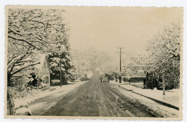
Photograph, Main Street Sassafras in Snow, c1952
The Main Street of Sassafras c1952 showing Mechanics Institute at left under snow. Note the hedge around the area that is now the Village Green. At the time of the photo the land belonged to Eva Shugg where she ran holiday flats called St Annes. Eva Shugg sold her house to Max Dower to extend his nursery in the 1970s and built a new home around the corner on Mountain Highway. At this time she donated part of her remaining land to form a Village Green. Eva Shugg lived to the age of 106 and died in 2007.Black and white photograph with serrated edge showing the Main Street of Sassafras under snow c1952. Mechanics' Institute is on LHS with cars parked outside the site of Sassafras House.On reverse written in pencil 'Main Street, Sassafras"sassafras, snow, mechanics' institute, mechanics' hall, village green, eva shugg, max dower -
 Melbourne Legacy
Letter, Re Balnarring Camp Property, c.1930
Referring to the legal history and transfer of land for the Junior Legacy Club Balnarring camp from Legatee Savige. Melbourne Legacy provided camps for junior legatees - the children of deceased servicemen. It started with outings to the property of Legacy founder, Legatee Stan Savige, who had a place in Balnarring. Permanent camp buildings were built in 1930. Lord Somers (Governor of Victoria) also ran a camp in the area and the area became known as Somers. These documents record the transfer of the land to Legacy. The camps gave the children an opportunity of a summer beach holiday with other Legacy children.An important record of the history of the land owned by Stan Savige that was used for Legacy Camp, it adds to the other material available about Legacy Camp at Somers.White foolscap paper with black typed x 5 pages. Single sided. Black type with red corrections and some grey lead remarks. Addressed to ‘The chairman,/ Junior Legacy Club,/ 55 Market Street,/ Melbourne. C.1. From ‘Yrs Faithfully/ sgd/ J.H. Armstrong and W. A. Tregent. See also collection item 00253. somers camp, properties, land transfer -
 Kew Historical Society Inc
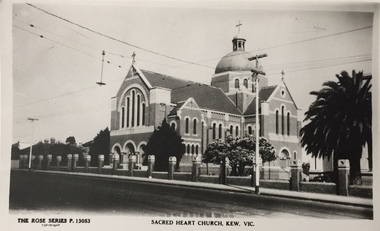
Print, Rose Stereograph Company, Sacred Heart Church, Kew, Vic, Twentieth Century
The history of the church goes back to 1872 when Jesuits purchased land in Walpole Street. By 1875 Archbishop Gould had laid a foundation stone on 14 February for a school. Early services for local Catholics were held in Richmond, Collingwood and later Hawthorn. By 1899 the land for the current church was purchased after a donation by Mr James Crotty of 3,000.00. The foundation stone was laid on 15 December 1918 by Archbishop Mannix. The dimensions of the church were to be 139 feet long by 77 feet wide with seating for 850 people. The cost of construction was 15,000.00. (Source: www.churchhistories.net.au )Sacred Heart Church, Kew, Vic., circa 1920-54. Photographic print of a Rose Stereograph Co. postcard in the State Library of Victoria collection.Inscription: The Rose Series P. 13053, Sacred Heart Church, Kew, Vic." Annotation in pencil: "KH-5. Foundation Stone laid 1918, completed 1921."churches -- kew (vic.), sacred heart church -- cotham road -- kew (vic.), catholic churches -- melbourne (vic.) -
 Kew Historical Society Inc
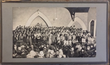
Photograph - Choir, Kew Baptist Church, c.1923
The first Baptist church in Kew was wooden and erected in St John's Parade in 1854 and was enlarged in 1859. A brick church was later erected in Cotham Road in 1882 and was later named Newnham Hall after Reverend Newnham. In 1921 land was purchased in Highbury Grove at a cost of 602.00. Messer's E & F Ratten donated 6 feet of land beside this new purchase which allowed for a frontage 79 feet. The Foundation stone of the current church was laid on 14 October 1922 by Councillor F.R. Patten J.P. The church was opened on 9 June 1923.A rare item from an outstanding and diverse photographic collection, assembled by members of the Christian and Washfold families of Kew.Photographic positive on mounting board. interior of Baptist Church in Highbury Grove with seated congregation in foreground and serried ranks of children and adults at front. Probably the church choir at the opening of the church in 1923. The photo is encased in a grey bifold cardboard outer with a crest on the front. The photo is protected by a sheet of watermarked cellophane. washfold family, kew baptist church -- highbury grove -- kew (vic.), churches -- kew (vic.), christian-washfold collection -
 Kew Historical Society Inc
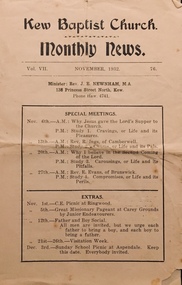
Journal, Kew Baptist Church Monthly News Vol VII November 1932, No. 76, 1932
Bi-fold pamphlet on brown paper. Kew Baptist Church Monthly News Vol VII November 1932, No. 76non-fictionkew baptist church -- highbury grove, churches -- kew (vic.), baptist churches, christian-washfold collection -
 Ballarat Diocesan Historical Commission
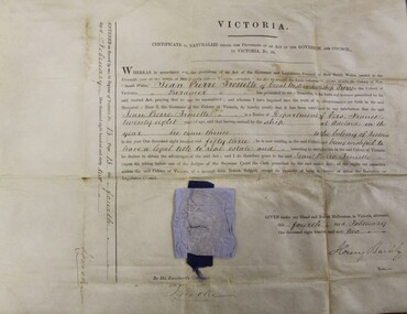
Certificate, Victorian Naturalisation Certificate
Jean-Pierre Trouette was natuarlised in 1862 the year he, his wife Anne (nee Blampied) and her brother Emile purchased land at Great Western and established the Great Western wineries. Unless a person was a Victorian citizen they could not own freehold land and run a business. This certificate testifies to Trouette's legal status and entitlement to establish the Great Western vineyards. At the Intercolonial Exhibition in Melbourne in 1866 his wines were noticed and was noted also in 1867. His vineyard was named St Peter's and visitors included Hubert de Castella in 1882. blampied, trouette, great western, st peter's, intercolonial exhibition, naturalisation, henry barkly -
 Wooragee Landcare Group
Photograph, 5 September 2004
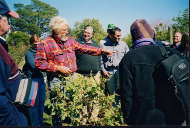
This photograph was taken during a bus excursion to Tatong in North East Victoria, held by the Wooragee Landcare Group in September 2004. The purpose of the excursion was to look at land use on small farms. As part of this, the excursion included a visit to Samaria Farm, run by Sue and Don Matheson. In this photo, taken at Samaria Farm, Don Matheson is discussing the management of his commercial rose garden. Events like this meet Wooragee Landcare's organisational goals of promoting best land management practices, cooperating and engaging with landowners, and providing information on plant management and care. This object is significant as a record of Wooragee Landcare's activities and community involvement. Landscape colour photograph printed on gloss photographic material. Reverse: "WAN NA E0NA2N2 NNN+ 1 4240/ -
 Warrnambool and District Historical Society Inc.
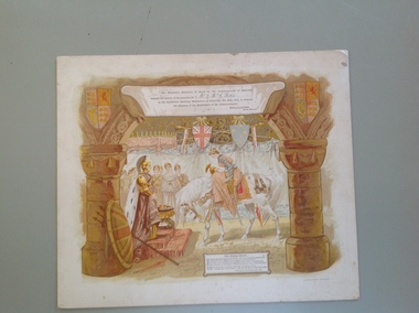
Certificate - Open Commonwealth Parliament, 1901
This is an invitation to George and Annie Rolfe of Lyndoch, Warrnambool, to attend the opening of the first Australian Parliament in Melbourne in May 1901. A smaller invitation card was first sent to the recipients and this larger invitation was sent after the event for the recipients to keep as a souvenir. The six Australian colonies became six Australian States in the newly-formed Commonwealth of Australia in January 1901. George Rolfe (1836-1919), a tea merchant from Melbourne, began buying blocks of land in Warrnambool near the mouth of the Hopkins River in the 1870s. By the early 1880s Rolfe owned 50 acres of land in the town and other nearby pastoral properties. He used the existing building on the land near the mouth of the Hopkins River as holiday accommodation, calling the property Lyndoch and adding stables, bone and chaff sheds, jetty, boathouse, reservoir and windmill and an extensive garden. George Rolfe spent most of his later life at Lyndoch. Today the area is the site of an aged care facility. This certificate is of considerable importance for two reasons: 1. It is an important memento of a signal event in Australia’s history – the Federation of the States in 1901. 2. The certificate was an invitation to George Rolfe of Lyndoch and his wife. Rolfe was a prominent Warrnambool person at that time. This is a piece of cardboard containing an illustration of a young queen in battle dress and on horseback bowing to an image of Britannia. The queen is about to be crowned. There are several lady attendants in the background and two large columns depicted on the sides of the illustration with shields and banners. An extract from Kipling’s poem, The Young Queen, is printed at the bottom of the card. The invitation is coloured in brown, yellow, white and orange tonings. The name of the recipient of the card is handwritten in black ink. The card is slightly scuffed and marked. The card is an invitation to Mr and Mrs Rolfe to attend the Opening of the First Australian Parliament in Melbourne in May 1901. ‘Mr & Mrs G. Rolfe’ federation in australia, george rolfe and family, history of warrnambool, lyndoch warrnambool -
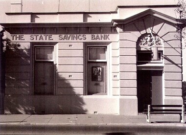 Wodonga & District Historical Society Inc
Photograph - State Bank of Victoria, Wodonga
The Title for the land on which this building stands was granted on 27 August 1857 and the land was bought by Keith Field and A. Maitland. It stood on 1 / 2 acre of land with 250 lengths down South Street and 200 lengths along Sydney Road. The 1 / 2 acre block on the northern side was also purchased by the same buyers. The State Savings Bank was built in 1915, just three years after the State Savings Bank of Victoria was established. It was branch number 731. The building served as a bank until about 1970. It is now owned and used as an office by a local law firm. It is a single storey rendered masonry building with a parapet concealing the roof. Key features of the High Street facade are horizontal bands of masonry, timber windows outlined with moulded details and ornamentation accentuated the door. A more modern branch was opened in a more central location in HIghs Street. The State Bank of Victoria was taken over by the Commonwealth Bank in 1990. These images record the premises of a bank which served the Wodonga community and businesses for many years.3 photos of the State Bank of Victoria in High Street Wodonga at various points in its history.state bank, wodonga businesses, financial institutions wodonga -
 Surrey Hills Historical Society Collection
Photograph, Kleinert family gathered fro Christmas celebrations at 34 Union Road, Surrey Hills
William was a coach-builder, wheelwright and blacksmith. He moved from Prahran to Surrey Hills to property owned by the family. The house at 34 Union Road was built in 1905 for William and his wife Emily. Their son Ernest worked with him as a coach painter and also worked as a painter undertaking intricate hand painting on early cars. Their other son Martin played for the Surrey Hills Football Club. In return for the support given to the club by Mrs Emily Kleinert, the club built a rotunda in South Surrey Park as a memorial to her. Alan Holt research: Lot 6 was sold to Martin Kleinert by Karl Richter in 1860 together with a portion of another adjacent lot. From 1860-1885 Martin worked it as a market garden leasing some land for grazing when it was not required for gardening. He died in 1898. In a formal document, William declared he was the son of Martin "who purchased land in 1860, died in 1898 and the land has been continually occupied by father and family since. It has been cultivated as a market garden; when not being used for gardening it was let for cultivation and grazing." William died in 1939 and the property passed to his sons Martin and Ernest. The Kleinert land extended from Union Road to Essex Road. They ran horses, ducks and fowls and Emily Kleinert grew flowers. The Kleinert property later became the South Surrey Park. The family sold the land to the Camberwell Council in the 1950s. Ernest and Ida Kleinert lived on the corner of Scotsdale and Warrigal Roads. The donor of the photo Nada Harris, nee Kleinert, was Ernest and Ida's daughter. Ida lived to a good age (> 93 years) and in later life lived in Burwood.Black and white photo of a large group of men, women and children posed for the photograph which is taken outdoors. William Kleinert is identified as seated in the front centre playing his German melodion. Sons Ernest and Martin and William's daughters Ivy and Rose are also in the photo (not identified). Nada Kleinert (daughter of Ernest and Ida and 1st grand-daughter of William and Emily) is standing next to her great-grandmother Radford.surrey hills football club, blacksmiths, wheelwrights, coachbuilders, south surrey park, rotunda, miss ida kleinert, emily kleinert, mr william kleinert, miss ivy kleinert, miss rose kleinert, mr ernest kleinert, miss nada kleinert, mrs nada harris, mr martin kleinert -
 The Beechworth Burke Museum
Photograph - Lantern Slide, c1900
Miners from Snake Valley lobbied the Victorian Government in 1855 to make land available for sale for farming purposes as an alternative occupation and income for people who wished to stay in the region but move away from gold mining. A secondary motivation was to increase the supply of fresh produce and decrease prices of items that otherwise needed to be transported from Melbourne or other regions. Forty-three country lots were initially offered in the Three Mile area, ranging in size from two to ninety acres and costing from £1 to £3 per acre. An additional eighty-five country lots were auctioned later in the year, in addition to many smaller suburban lots. More lots were offered than sold, initially, but this represented conditions of sale requiring the total purchase cost up front which many people interested in purchasing could not afford, especially as land purchased for farming would accrue substantial additional costs for clearing and labour before becoming productive. Further lobbying activities and the election of parliamentary members sympathetic to the cause took place through the 1850s. Ovens Parliamentary Member, Daniel Cameron, was re-elected in 1856 on a platform of surveying the land for public selection with deferred payment options. Land reform remained an issue in the area through the 1850s and early 1860s, impacting broader decisions in the new State of Victoria relating to voting rights, use of Crown land and the farming of land that wasn't always suitable for the purpose. This photograph depicts Beechworth in approximately 1900, after several waves of land sales resulted in increasingly levels of development. Lantern slides, sometimes called 'magic lantern' slides, are glass plates on which an image has been secured for the purpose of projection. Glass slides were etched or hand-painted for this purpose from the Eighteenth Century but the process became more popular and accessible to the public with the development of photographic-emulsion slides used with a 'Magic Lantern' device in the mid-Nineteenth Century. Photographic lantern slides comprise a double-negative emulsion layer (forming a positive image) between thin glass plates that are bound together. A number of processes existed to form and bind the emulsion layer to the base plate, including the albumen, wet plate collodion, gelatine dry plate and woodburytype techniques. Lantern slides and magic lantern technologies are seen as foundational precursors to the development of modern photography and film-making techniques.This glass slide is significant because it provides insight into Beechworth's built environment and infrastructure in the early Twentieth Century, around the time of Australia's Federation. It is also an example of an early photographic and film-making technology in use in regional Victoria in the time period.Thin translucent sheet of glass with a square-edged image printed on the front and framed in a black backing. It is held together by metal strips to secure the edges of the slide.burke museum, beechworth, lantern slide, slide, glass slide, plate, burke museum collection, photograph, monochrome, indigo shire, north-east victoria, farming, squatters, miners, agriculture, land-clearing, land reform, daniel cameron, land sales, three mile, snake valley, tarrawingee -
 Ringwood and District Historical Society
Pamphlet, Subdivisional Auction Sale, Bedford Park, Ringwood - 1924
Bedford Park subdivisional development did not eventuate. The land adjoining the railway line became parkland with provision for sporting facilities and the remainder was purchased by the Education Department as the site for Ringwood High School/Secondary College. Double sided bifolded auction sale advertisement including subdivision features and local facilitiesSubdivision plan includes Bedford Road, Graham Road, Joyce Street, Anderson Street, and Adams Street -
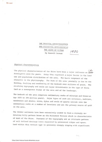 Eltham District Historical Society Inc
Folder, The Physical characteristics and historical development of the Shire of Eltham by Russell Yeoman, 1980
12 page essay describing the physical characteristics, major landform features and historical development of the Shire of Eltham. Includes photocopy of part of unsourced newspaper article describing early land holders and roads in the area.14 pagesHG Booklet 38harry gilham collection, russell yeoman, geography, history -
 Greensborough Historical Society
Slide - Photograph, John Ramsdale, Rural panorama: Slide 14
Photograph shows view across a road and open land to large house in a rural setting. At the time of the photograph was named 'Odyssey House' at Lower Plenty, Pre 1976 it was known as the Blessed Sacrament Fathers Seminary.Part of the John Ramsdale collection of slides and audio visual material.Colour photograph scanned from slide.No maker's marks. No caption on slide.rural landscape -
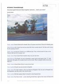 Greensborough Historical Society
Article and Photograph, All Saints' Greensborough, 2018_
Information and photos of the original All Saints' Church of England in Greensborough; the land was later sold to Coles to build a new store and the Church was rebuilt on its current site on corner of Grimshaw and Church Streets Greensborough. This photograph and text was copied from a Facebook site. Members are people who lived in the Greensborough area and share their reminiscences of the area with others. The site is administered by a GHS member but is not officially affiliated with the Society. Any information is the opinion of the contributor. Article and photograph sourced from social media.all saints church of england, all saints anglican church greensborough -
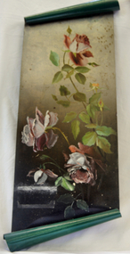 Orbost & District Historical Society
Painting, Cameron, Grace (Miss), Circa 1920-1930
Grace Cameron was the daughter of John Cameron who selected the first land on the Snowy River flats. She was the sister of Annie (later Mrs John Gilbert) who was the first white girl born in Orbost.This item is aesthetically significant and shows the skill and craftmanship of the women of the early settler families.Large oblong oil painting on green painted tin with the top and bottom rolled for decoration. Painting of three single petalled pink roses in full bloom with two small buds.tin painting cameron-grace art