Showing 3211 items
matching road maps
-
 Melbourne Tram Museum
Pamphlet, Prahran & Malvern Tramway Trust (PMTT), "Information for passengers - Round trip through Melbourne and Suburbs by Cable and Electric Tramways", c1918/19
Pamphlet - special size sheet, was originally folded into three titled "Information for passengers - Round trip through Melbourne and Suburbs by Cable and Electric Tramways", giving details of the trip, where the trams could be boarded, Description of Route, map shows the route along with other tram routes. Also show railway stations. Has a photo of a PMTT single trucker. c1918/19 2 copies held.trams, tramways, pmtt, cable trams, tours, round trip, map -
 Melbourne Tram Museum
Map, Melbourne & Metropolitan Tramways Board (MMTB), Report - "Melbourne and Metropolitan Tramways Board General Scheme", May. 1923
.1 - Printed document - 1923 - Report - 8 pages - The Parliamentary Standing Committee on Railways - General Scheme for Tramways for Metropolis - printed 24/7/1923. Gives details of the committee, the committee report, comments on the Board's financial position, the debate between tramways or railways, recommendations and views of the Railways Commissioners. .2 - Associated map - Map - drawing with a line back, titled "Melbourne and Metropolitan Tramways Board Proposals for General Scheme". Shows the proposed tram lines submitted to Parliament for the report into the General Scheme. Printed by Sands & McDougall Pty Ltd. Signed by J. P Strickland dated 27-8-1923. .3 - as for .1, but in good condition - added 27-3-2018 from donation of Norm Cross.trams, tramways, mmtb, general scheme, tramways, development, parliament, brighton, railways, finances, map -
 Melbourne Tram Museum
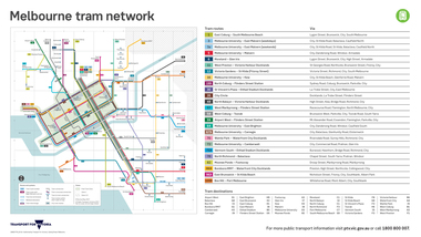
Map, Transport for Victoria, "Melbourne tram network", Feb. 2018
Digital Image of the Feb. 2018 version of the tram and route map for Melbourne titled "Melbourne tram network". Published by Transport for Victoria, effective May 2017 following changes to routes, in particular route 58. Shows each of the route, terminal points, with a legend. Note does not have Yarra Trams logo.trams, tramways, maps, transport for victoria, melbourne, routes -
 Melbourne Tram Museum
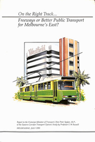
Document - Report, Professor E. W. Russell, "On the right track .. Freeways of Better Public Transport for Melbourne's East?", Jul. 1991
Report - 120 pages + cover perfect bound - titled "On the right track .. Freeways of Better Public Transport for Melbourne's East?", to the Victorian Minister for Transport Hon. Peter Spyker by Professor E. W. Russell, dated July 1991. Has a table of contents. Report looks at the options for transport to the Doncaster area, freeways, light rail or tram or heavy rail, considers options for the extension of routes 48 and 72 (along Burke Road), buses, tram line from Shoppingtown to Box Hill. Includes illustrations and maps.trams, tramways, public transport, doncaster, box hill, new tramway, route 48, route 72 -
 Melbourne Tram Museum
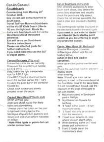
Document - Instruction, Yarra Trams, "Car-in/Car-out/ Southbank", 20/10/2008 12:00:00 AM
Instruction - single A5 sheet, titled "Car-in/Car-out/ Southbank", providing instruction on how to enter and leave the new Southbank Depot commencing Monday 20th October 2008. Gives instructions on entering the depot from either the City of Port Melbourne end. 2nd copy with map or diagram of the Southbank depot layout added 17/6/2019 donation from Ron ScholtenOn rear in ink "East front / west is back"trams, tramways, yarra trams, driver training, training, southbank depot -
 Melbourne Tram Museum
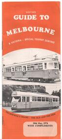
Pamphlet, J B Publications, "Visitors Guide to Melbourne", May. 1974
Pamphlet - 28 pages, centre stapled titled "Visitors Guide to Melbourne", dated 20 May 1974. Has on front cover trams W7 1032 and PCC 1041 with the caption "Melbourne's Trams - the old and the new" Has many advertisements, a small map, places of interest including Sovereign Hill, Leonda, driving in central Melbourne and wearing of seat belts. Has photo looking north along Swanston St - see image 2. Welcome by Minister for Tourism Murray Byrne.trams, tramways, melbourne, visitors, guides, w7 class, 1041, tram 1032, tram 1041 -
 Melbourne Tram Museum
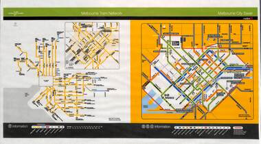
Poster, Yarra Trams, "Melbourne Tram Network", Nov. 2005
Full colour poster printed, A3 size, on laminated sheet - titled "Melbourne Tram Network. Shows a diagrammatic layout of the Melbourne tram system, shows zones (2 zones), CBD, tram terminuses including the City Saver boundary. Has the Yarra Trams and Metlink logos. Dated Effective November 2005trams, tramways, yarra trams, metlink, maps, metcard, tickets, city section -
 Melbourne Tram Museum
Document - Instruction, Metropolitan Transit Authority (MTA), "A New Fare System for Melbourne Staff Training Instructions", Nov. 1983
Instruction - 18 A4 photocopied sheets with the Metropolitan Transit Authority of Victoria logo and head titled "A New Fare System for Melbourne Staff Training Instructions" detailing the introduction of the Neighbourhood Ticketing System from 13/11/1983. Details the Neighbourhoods, 10, map of the rail lines, availability, weekly and other cars, use, conditions, refunds, accounting procedures and other changes.trams, tramways, neighbourhood tickets, the met, mta, tickets -
 Melbourne Tram Museum
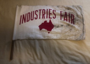
Flag, "Industries Fair", c1990
Flag advertising the Industry Fair, red print on white background with a map of Australia, printed on both sides, mounted on wooden dowel for use on Melbourne tramcars. Flag made from two layers of cotton, sewn edges, sewn into a white cotton circular section with an cloth cap and then slipped over the dowel and held in position with a single tack. No manufacturers label.trams, tramways, flags, melbourne, events -
 Melbourne Tram Museum
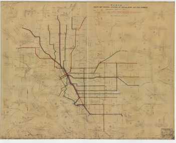
Drawing, Melbourne & Metropolitan Tramways Board (MMTB), "Route Map showing location of special work and pole numbers" "Electric Tramway Routes - showing routes in colours and numbers", late 1941
... Melbourne Tram Museum 8 Wallen Road Hawthorn melbourne Map ...Map of the system shown at two inches = 1 mile. Drawing No. P5799. Shows crossovers, track layouts at junctions, signal cabins roads, railways and stations. Originally signed by Perway Engineer - 20/12/1940, though originally drawn in 1922. Has been marked up in coloured pencil to show the routes and route numbers. The plan shows the lines to Maribyrnong Munitions works along Cordite Ave and Wests Road and the track from Moonee Ponds to Union Road, which opened in July 1941, but not the extension to Essendon Airport built-in 1942. See Reg Item 1561 for a 1963 version and 1683 for a 1987 versionDemonstrates the use of a MMTB drawing to show tram routes and their route numbers at the time.Drawings - dyeline cloth backed print - titled - "Route Map showing location of special work and pole numbers" and subtitled - "Electric Tramway Routes - showing routes in colours and numbers". trams, tramways, mmtb, trackwork, tramways, junction, map, world war 2 -
 Melbourne Tram Museum
Drawing, Melbourne & Metropolitan Tramways Board (MMTB), "Route Map showing location of special work and pole numbers" "All night tram routes in colours", late 1941
... Melbourne Tram Museum 8 Wallen Road Hawthorn melbourne Map ...Map of the system shown at two inches = 1 mile. Drawing No. P5799. Shows crossovers, track layouts at junctions, signal cabins roads, railways, and stations. Originally signed by Perway Engineer - 20/12/1940, though originally drawn in 1922. Has been marked up in colour pencil to show the all-night routes and the individual services. The plan shows the lines to Maribyrnong Munitions works along Cordite Ave and Wests Road and the track from Moonee Ponds to Union Road, opened in July 1941, but not the extension to Essendon Airport built in 1942.Demonstrates a detail drawing of Melbourne tramways, junctions and pole numbers.Drawings - dyeline cloth-backed print - titled - "Route Map showing the location of special work and pole numbers" and subtitled - "All night tram routes in colours". trams, tramways, mmtb, trackwork, tramways, junction, map, world war 2, night trams -
 Melbourne Tram Museum
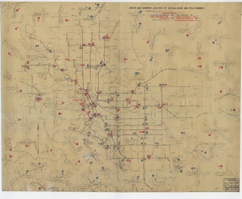
Drawing, Melbourne & Metropolitan Tramways Board (MMTB), "Route Map showing location of special work and pole numbers" "substations", late 1942
... Melbourne Tram Museum 8 Wallen Road Hawthorn melbourne Map ...Map of the system shown at two inches = 1 mile. Drawing No. P5799. Shows crossovers, track layouts at junctions, signal cabins roads, railways, and stations. Originally signed by Perway Engineer - 20/12/1940, though originally drawn in 1922. The plan shows the lines to Maribyrnong Munitions works along Cordite Ave and Wests Road and the track from Moonee Ponds to Union Road, opened in July 1941, and the extension to Essendon Airport built in 1942, but not the Queen St North Essendon substation. Shows underground cables, tram and bus depot, workshop locations, and substation locations and their priority.Yields information about the MMTB substation locations in 1942.Drawing - dyeline cloth backed print - titled - "Route Map showing location of special work and pole numbers" and subtitled - "Substations". trams, tramways, mmtb, trackwork, tramways, junction, map, world war 2, substation -
 Melbourne Tram Museum
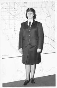
Photograph - Black & White Photograph/s, late 1960's
Black and white photograph - Conductress - cap badge 3732 standing in front of a large map of Melbourne - Late 1960s and this uniform flowed into the early 1970'strams, tramways, personnel, uniforms, conductresses -
 Melbourne Tram Museum
Pamphlet, Yarra Trams, "Join us for the centenary celebrations of Kew Tram Depot 1915-2015", Apr. 2015
Pamphlet - 3 fold DL, full colour titled "Join us for the centenary celebrations of Kew Tram Depot 1915-2015" giving details of the event on 3 May 2015. Has a timeline history of the depot, photo of tram 60, and map showing activities. Has logos of Yarra Trams, PTV and State Government. Two copies held.trams, tramways, kew depot, centenaries, yarra trams -
 Melbourne Tram Museum
Map, "Tramway and Light Rail System - with substations", 1988
Map or Plan, titled "Tramway and Light Rail System", showing the routes as in 1988 with substations located and their abbreviation and name. Has an enlargement for the city area. Also locates depots and the location of the Carlton Centre control centre Not known who prepared the plan.trams, tramways, map, substation, depots, power supply, electrical engineering -
 Melbourne Tram Museum
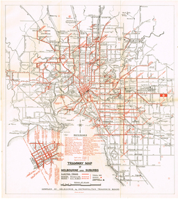
Map, "Tramway Map of Melbourne and Suburbs", c1952
... Melbourne Tram Museum 8 Wallen Road Hawthorn melbourne Map ...Map of Melbourne's Tram and Bus routes, route destinations, MMTB Guest houses, all-night bus routes, depots, golf links and sporting grounds, rail lines, and location of major places of interest. Titled - "Tramway Map of Melbourne and Suburbs" - c1952, after the La Trobe or Latrobe St lines opened. Not known who produced the map. Does not give route numbers. See also Reg Item 2300 for an MMTB Map of the same era, 7315 for a similar version but without the guest houses, and 4525.1 for an MMTB Photograph.Yields information about Melbourne tram routes prior to Bourke St being built.Fold out map (6 sections), two colours. Has been removed from a book with the remnants of other paper in the top left-hand side.trams, tramways, melbourne, map, tram & bus services, all night services, mmtb, guest houses -
 Melbourne Tram Museum
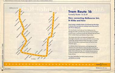
Newspaper, Progress Leader, "Tram Route 16", 11/10/2004 12:00:00 AM
Newspaper clipping titled "Tram Route 16", advert in the Progress Leader 11/10/2004 about the combining of routes 69 and 16 Melbourne University St Kilda and Kew from 17/10/2004. Has a Map of the route, Metlink contact details and Yarra Trams logo.trams, tramways, route 69, route 16, kew -
 Melbourne Tram Museum
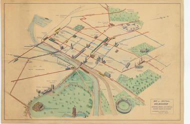
Map, Melbourne & Metropolitan Tramways Board (MMTB), "Map of Central Melbourne", c1952
Map - dyeline print then hand coloured, titled "Map of Central Melbourne", subtitled "Showing tram and bus routes, railways, places of interest:. Includes railway yards. gardens, trams routes shown in direction in some places. Has initials WKGP in bottom right hand corner. Map c1952, after the Latrobe St lines opened but before Bourke St lines opened. Note: 1 - The Hanna St or South Melbourne depot is shown south of City Road, not south of Sturt Street as it should have been. 2 - route 78 shown terminating at Batman Ave is incorrect, ran from Victoria and Church Sts. Original document scanned as a high res tiff file, approx. 60MB, see large files directory - htd3736-large.tiftrams, tramways, mmtb, map, melbourne, tram routes, south melbourne depot, hanna st depot, latrobe st, la trobe st -
 Melbourne Tram Museum
Map, Tourist Development Authority of Victoria, "Melbourne Holiday City", c1963
Fold out map (8 sections 4 across x 2 deep), coloured of Melbourne's Tram and train routes, route numbers, rail lines, detailed for Melbourne and suburbs. On rear description is map of CBD and places of interest. Has contact details for cinemas, theatres and sporting venues.trams, tramways, melbourne, map, tram & train services, railways, mmtb -
 Melbourne Tram Museum
Pamphlet, Public Transport Victoria (PTV), "Buses replace trams", Feb. 2019
Pamphlet - six fold - A3 to DL side three colour printed on off-white paper, titled "Buses replace trams", advising intending passengers of the work between 23/2/2019 and 7/3/2019 due to track renewal on Holmes and Nicholson streets in Brunswick. Has a map, list of service changes, bus replacement guides and contact information. Has the logos of Transport for Victoria, Yarra Trams and PTV. Two copies held.trams, tramways, nicholson st, holmes st, tramway construction, route 1, route 6 -
 Melbourne Tram Museum
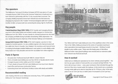
Pamphlet, Melbourne Tram Museum, "Melbourne' cable trams 1885-1940", 2019
Pamphlet, one fold, titled "Melbourne' cable trams 1885-1940", created by Geoff Brown for a tour of cable tram buildings for his Probus group on 6 Feb 2019. Has a map showing the Melbourne Cable Tram Network and a brief history of the cable tram network.trams, tramways, melbourne, map, routes, cable trams -
 Melbourne Tram Museum
Pamphlet, Public Transport Victoria (PTV), "City Circle", 2019
3 fold, DL pamphlet for Melbourne visitors & tourists describing the city circle tram. Provides running times with map showing various Melbourne tourist attractions.trams, tramways, city circle, melbourne, passengers, tourist guides, route 35 -
 Melbourne Tram Museum
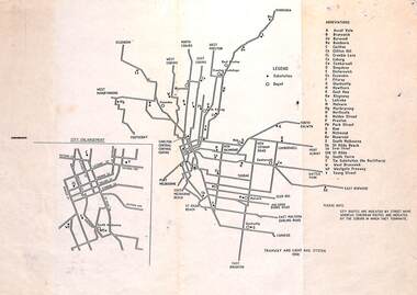
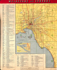
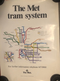
Map, Public Transport Corporation (PTC), "The Met tram system", early 1990's
Poster - large full colour poster for walls in railway stations and shelters, titled "The Met tram system", showing the tram system, early to mid 1990's. Has The Met contract number and that it was published by the Public Transport Corporation.trams, tramways, map, ptc, the met, melbourne, tramways -
 Melbourne Tram Museum
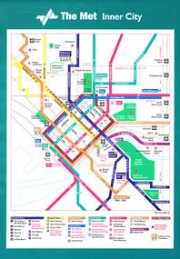
Poster, Public Transport Corporation (PTC), "Public Transport Corporation - Your travel made easy", late 1990s
Set of six large posters, featuring the tram map of Melbourne, Inner City, Northern and Southern sections. Items .1 to .3 have an adhesive backing for application onto a tramcar advertising rack. Items .4 to .6 are photocopies of the same with corrections or suggested changes, all c1990. .1 - Inner City - approx. A3, Has the revised The Met symbol with a key along the lower edge detailing route numbers and routes. .2 - Southern Region Tram Map with a map key showing hospitals, points of interest, parks and gardens, some schools and zones. Also shows trams routes through the city, rail lines, stations and major roads with bus routes. .3 - ditto for the Northern Region .4 - Photocopy of the Inner City area with corrections which have been picked up on the final version. .5 - ditto for the Southern Region, two sheets joined together with tape. .6 - ditto for the Northern Region. Items .4 to .6 not scanned.trams, tramways, ptc, posters, trams, the met, map, tram routes, bus routes, route numbers -
 Melbourne Tram Museum
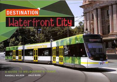
Book, Randal Wilson, Dale Budd, "Destination Waterfront City", 2014
Book - 80 pages, A4 landscape format pages including card covers, full colour printing on gloss paper, titled "Destination Waterfront City" written by Randal Wilson and Dale Budd of 2014. Covers Melbourne tram history including cable trams, early electric trams, trams in art, historic fleet, colour schemes, tram types, depots, ticket machines, maps, principally looking at the then current Melbourne fleet. Includes notes on the authors. Has a photo of E6003 on the front cover.trams, tramways, melbourne, tramways, history, e class -
 Melbourne Tram Museum
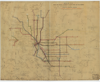
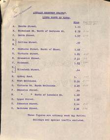
Document - Report, Tramway Board, "Average Shortest Headway lines north and south of the Yarra", c1916 to 1920
Set of typed sheets and map: .1 - carbon copy on quarto paper titled "Average Shortest Headway lines north of Yarra", giving the average headway for each street, route, eg Collins St, .57mins and for West Melbourne 8.5mins. Has in pencil alongside in pencil, the times for "Royal Commission Report 1911" .2 - ditto "Average Shortest Headway lines south of Yarra" Has a note that these numbers were for ordinary weekday tables, holidays and special traffic excluded. .3 - Map - accompanied these reports, titled "Map showing tramway Lines", which has been marked up in red with numbers and the road names. Not understood what the numbers mean, could be a reference to a report numbering. All documents undated, c 1916 to 1920.1 - has stamp "Copy to Engineer" in top left hand corner.trams, tramways, cable trams, reports, services, map, mto co, royal commission, timetables -
 Melbourne Tram Museum
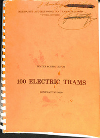
Document - Tender Document, Melbourne & Metropolitan Tramways Board (MMTB), "Tender Schedule for 100 Electric Trams Contract No. 3000", Apr. 1977
Comb bound (white plastic) specification or tender document, approx. 180 pages, with glossy card orange covers, titled "Tender Schedule for Electric Trams" and "Contract 3000". Compiled and published by the Melbourne and Metropolitan Tramways Board, closing Monday 10 May 1977. Details the conditions of tender, conditions of contract, notes, specification, gives background information about Melbourne, dimensions, performance, drivers and conductors, trucks, wheels, brakes, electrical equipment, control panels and drawings. The drawings give a map of the system, typical city route, Glenferrie Road route (grade diagram), concrete track construction, min. radius curves, loading gauge, all-electric tram and mounting details for the trolley base, schedule of prices, tender form, form of contract, schedule of information to be provided by the tenderer. Includes an Alphabetical Index. Includes a drawing for a single ended version of the tramcar. Became the Z3 class. Only the table of contents and the drawings scanned. See Reg Items 1583 and 2266 for other similar documents. See Reg Items 337 and 338 for a report on the operation of single ended tramcars 2 copies held.Has in ink written on front cover "J Armstrong" with a stamp blacked out and other copy of the same signature.trams, tramways, z3 class, specification, tenders, mmtb, melbourne, single ended tramcars -
 Melbourne Tram Museum
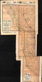
Map, Morgan Street directory - map of VR Trams, Map - 1940s?
Map - assembled from sheets of the Morgan Street directory for the two VR street tramways from St Kilda to Brighton and from Sandringham Station to Beaumaris or Black Rock. Comprises four sheets taped together and one loose sheet. Tram route marked in green felt pen. Has many adverts on the rear and front for funeral parlours, hotels, real estate agents and the like.trams, tramways, map, vr, sandringham, black rock, beaumaris, brighton, st kilda -
 Melbourne Tram Museum
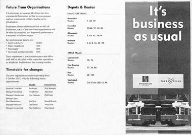
Pamphlet - PTC split, Public Transport Corporation (PTC), It's business as usual, 9/1997
Gives details of the split of the tram division of the Public Transport Corporation Vic to come into effect on 1-10-1997 into two business divisions - Yarra Trams and Swanston Trams. Includes a map showing which entity was to operate what section of Melbourne Trams. Prepared for employee information. Provides information on who would be the senior managers, a timetable, depots and routes to be operated and the logos that would be used.Yields information about the split of the Public Transport Corporation Tram division in preparation for the future privatisation. Pamphlet - photocopy titled Pamphlet - It's business as usual about the split up of the PTC to Swanston Trams and Yarra Trams. Two copies held.trams, tramways, yarra trams, swanston trams, ptc, managers, depots, public transport corporation -
 Melbourne Tram Museum
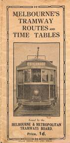
Map, Melbourne & Metropolitan Tramways Board (MMTB), Melbourne's tramway routes and timetables - MMTB, 1925
... Melbourne Tram Museum 8 Wallen Road Hawthorn melbourne Map ...Map of the MMTB Tramway routes 1925 with a list of first and last cars, along with photographs of Wattle Park, Luna Park, and Studley Park. Provides information for the Prahran and Malvern lines, Hawthorn, Footscray, Essendon, Coburg, Kew, St Kilda, cable tram routes, and buses. Also provides information for passengers. The cover photo is of the front of W 296, with the destination of Esplanade. The map is dated by the opening of the line to West Brunswick as far as Albion St, the City Road to St Kilda line via Sturt St lines, and the electric line in Flemington Road which were all opened during mid to late 1925. See Reference. Shows a number of buildings and locations by a numbered reference list, including the Federal Parliament house. The map has advertisements around the outside of the map for Kiwi Shoe or boot polish.Yields information about the Melbourne tramway system in 1925 and demonstrates the methodology the MMTB used to provide information to travellers. Shows both cable and electric tram lines and the development of the Melbourne system.Map book - 15 fold paper titled "Melbourne's tramway routes and timetables"trams, tramways, mmtb, tramway maps, wattle park, studley park, timetables, cable trams, w class tram, tram 296, kiwi shoe polish