Showing 7077 items
matching snowy-river
-
 Robin Boyd Foundation
Document - Script, Robin Boyd, The Flying Dogtor. Episode 47 Night Watch, 1963
The Flying Dogtor, called by the Government to Canberra to help solve the mystery of a monster or sea-serpent, that seemed to be threatening the Snowy Mountain Scheme, spent a night in a tunnel. He was waiting for the monster to appear, so that he could try to find out where it came from and what it wanted. Suddenly, he heard heavy breathing close behind him in the darkness.The Flying Dogtor" series was broadcast on Australian Television Network (later becoming the Seven Network) between February and April 1964 (see item D254 for schedule).Typewritten, carbon copy, foolscap, 2 pagesHandwritten pencil edits and additions.the flying dogtor, robin boyd, crawford productions, manuscript -
![Photograph - Digital image, Pioneer Children's Cemetery [from above], 1985_](/media/collectors/4f729f5697f83e03086015b8/items/54bb56202162f10ca8d79013/item-media/54bb56452162f10ca8d79127/item-fit-380x285.jpg) Greensborough Historical Society
Greensborough Historical SocietyPhotograph - Digital image, Pioneer Children's Cemetery [from above], 1985_
The unmarked graves of the children of two Greensborough pioneer families lie in a private cemetery on the Plenty River. Burials occurred between 1848 and 1860. This photograph is taken from above the cemetery site looking towards the Plenty River with the Maroondah Aqueduct in the background.An important historical site in Greensborough.Digital copy of colour photograph.pioneer childrens cemetery, plenty river, maroondah aqueduct, partington, whatmough -
 Orbost & District Historical Society
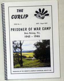
book, The Curlip - P.O.W.Camp Bete Bolong, Vic. 1943-1946, August 2007
This is Issue No. 5 of "The Curlip". The magazine is a compilation of research from a trip by the Orbost & District Historical Society to Bete Bolong. The Bete Bolong Prisoner of War Camp was located on the south side of the Buchan - Orbost Rd. From November 1943 to November 1945, Italian prisoners of war were based at Bete Bolong, cultivating maize, peas, beans and other vegetables on local farms. Unlike other 'farming' prisoners of war, those at Bete Bolong did not live with the farming families, but at a Prisoner of War Control Centre on Crown land overlooking the Snowy River Flats. About fifty Italian prisoners lived at the centre, along with an Australian Military Force staff of approximately seven people. The prisoners were driven to and from the farms each day. Three of them apparently simply swam across the river to work. They worked a six day week, with Sundays off. Although they were provided with rations, both prisoners and staff maintained vegetable and flower gardens. They were also skilled at cooking 'anything' they could catch, and at making illegal "grappa". Very few of the Italians were experienced farm workers. Some of them used their skills to make things for the families they worked for; a cabinet-maker made furniture , a cobbler made shoes, etc. They interacted with the local community and, although they were not supposed to go within one kilometre of town, some were found at local dances on Saturday nights. As recreation the prisoners were allowed to walk along the road to the west of the camp. Local people from both sides of the river could hear them sing as they walked. The prisoners also helped to construct an 'ant bed' tennis court on a property adjacent to the centre. Although now overgrown, the site of the tennis court can still be discerned as a flat area above the site of the centre. (ref./vhd.heritagecouncil.vic.gov.au)This item is a useful reference tool on the history of the Prisoner of War Camp at Bete Bolong, Orbost.A spiral bound book with a clear plastic cover. On the front is a coloured photograph of a view from the site of the P.O.W. camp at the intersection of Bete Bolong and Buchan Roads at Bete Bolong. Above is the title "Prisoner of War Camp Bete Bolong, Vic. 1943-1946" in black print on a white background. p.o.w.-camp-orbost ww11 bete-bolong -
![The Bend of the Yarra at Studley Park / [by] Nicholas Caire, circa 1876](/media/collectors/550653872162f11fb04854aa/items/5783120ed0cdd1176c47d8c8/item-media/57831278d0cdd1176c4805d6/item-fit-380x285.jpg) Kew Historical Society Inc
Kew Historical Society IncPhotograph, Anglo-Australasian Photographic Company, The Bend of the Yarra at Studley Park, c. 1876
Nicholas Caire was born on Guernsey in the Channel Islands in 1837. He arrived in Adelaide with his parents in about 1860. In 1867, following photographic journeys in Gippsland, he opened a studio in Adelaide. From 1870 to 1876 he lived and worked in Talbot in Central Victoria. In 1876 he purchased T. F. Chuck's studios in the Royal Arcade Melbourne. In 1885, following the introduction of dry plate photography, he began a series of landscape series, which were commercially successful. As a photographer, he travelled extensively through Victoria, photographing places few of his contemporaries had previously seen. He died in 1918. Reference: Jack Cato, 'Caire, Nicholas John (1837–1918)', Australian Dictionary of Biography.An original, rare photograph from the series 'Views of Victoria: General Series' by the photographer, Nicholas Caire (1837-1918). The series of 60 photographs that comprise the series was issued c. 1876 and reinforced a neo-Romantic view of the Australian landscape to which a growing nationalist movement would respond. Nicholas Caire was active as a photographer in Australia from 1858 until his death in 1918. His vision of the Australian bush and pioneer life had a counterpart in the works of Henry Lawson and other nationalist poets, authors and painters.‘The Bend of the Yarra at Studley Park’ : Views of Victoria (General Series) No.49 : Albumen silver photograph | Photo on card with Title and Description on reverse | Mounted 24 x 30 cm; Photo 12 x 17 cm.On Reverse: The subject of the present illustration is taken from near the Kew Road, on the Park-hill side of the Yarra. The curve of the River at this and other parts of the Park represents a gigantic letter S. It is a remarkable fact that the hilly side of the River is covered with a mass of foliage of various descriptions, from the stately gum tree to the stunted wattle, whilst the opposite side of flat country has scarcely a shrub to be seen any where.’nicholas caire (1837-1918), studley park, yarra river, kew, landscape photography - victoria -
 Kiewa Valley Historical Society
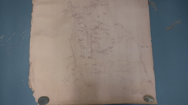
Map - Bogong High Plains
Bogong high Plains showing mountains, places, roads and riversHistorical changes of infrastructure on the Bogong High PlainsBogong High Plains, hand written and 'copied with considerable simplification from F.C.V. (Falls Creek V.?) 'Feathetop' L 'Tawonga'. Paper is yellowed, writing is brown.bogong high plains map -
 Greensborough Historical Society
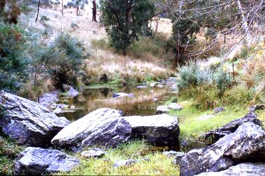
Slide - Photograph, John Ramsdale, Plenty Gorge: Slide 106, 1990s
Photograph shows a rocky area near river in Plenty Gorge.Part of the John Ramsdale collection of slides and audio visual material.Colour photograph scanned from slide.No maker's marks. No caption on slide.plenty river, plenty gorge -
 Greensborough Historical Society
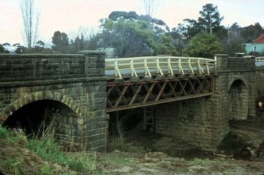
Photograph - Photograph - Digital Image, Bluestone bridge Greensborough 1960s, 1960s
A photograph of the bluestone bridge over the Plenty River at Greensborough 1960s.Digital copy of colour photograph. Second photo is cropped copy.bluestone bridge greensborough, plenty river greensborough, main street greensborough -
 Greensborough Historical Society
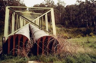
Photograph - Digital Image, Dual pipes: Aqueduct Greensborough, 2000c
Photograph of section of the Maroondah aqueduct over the Plenty River at Greensborough.Digital copy of colour photograph.maroondah aqueduct, aqueduct greensborough -
 Greensborough Historical Society
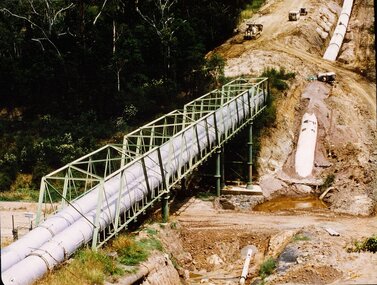
Photograph - Digital image, New pipeline replacing Watts Reservoir aqueduct, 1977_
Photograph of new aqueduct pipe near Plenty River Greensborough.Digital copy of colour photograph.aqueduct, maroondah aqueduct, plenty river -
 Greensborough Historical Society
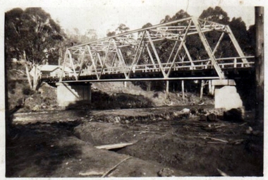
Photograph - Digital Image, Pipes over Plenty, construction of original bridge for Watts Reservoir aqueduct, 1950-1970
Photograph of the Maroondah aqueduct bridge over the Plenty River in Greensborough.Digital copy of black and white photograph.maroondah aqueduct, aqueduct, plenty river -
 Greensborough Historical Society
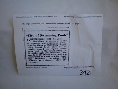
Newspaper clipping, City of swimming pools, 08/03/1937
A report on the opening of the Greensborough swimming pool in the Plenty River 1937.This pool on the Plenty River still exists today.Article downloaded from Trove (National Library of Australia).greensborough, swimming pools, plenty river, heidelberg city council -
 Greensborough Historical Society
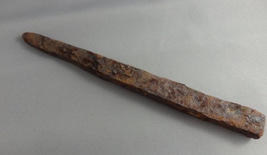
Spike, Hand forged metal spike, 1900c
Hand forged metal spike found along Plenty River.Hand forged metal spike. Some rust. -
 Greensborough Historical Society
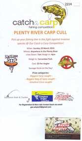
Advertising Poster, Aussie Angler, Catch a carp fishing competition, 29/03/2015
Flyer advertising the Plenty River carp cull March 2015Colour advertisement. Attached is business card.aussie angler, plenty river -
 Eltham District Historical Society Inc
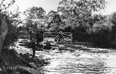
Negative - Photograph, Tom Prior, Friars Falls, Eltham, c.1910
Friars Falls is near Griffith Park, Eltham on the Yarra RiverThis photo forms part of a collection of photographs gathered by the Shire of Eltham for their centenary project book,"Pioneers and Painters: 100 years of the Shire of Eltham" by Alan Marshall (1971). The collection of over 500 images is held in partnership between Eltham District Historical Society and Yarra Plenty Regional Library (Eltham Library) and is now formally known as the 'The Shire of Eltham Pioneers Photograph Collection.' It is significant in being the first community sourced collection representing the places and people of the Shire's first one hundred years. The Reynolds family were early settlers in Research. The Reynolds/ Prior collection of photographs were taken by Tom Prior, the maternal uncle of Ivy Reynolds, around 1900 and the 60 photos in the album give a fine overview of many of the landmarks of Research and Eltham over 100 years ago. lvy lived in the family home for many years at 106 Thompson Cres Research. Ivy's father, Ernst Richard Reynolds and grandfather, Richard Reynolds, lived at the same address. Ivy's father Richard worked for Mr. Trail on his property in Research. Reynolds Road is named after the family. Mr Tom Prior (wife Eva) worked at the Melbourne zoo. He was very innovative and made his own camera, using the black cloth hood to exclude the light. The photographs are a reminder of the rural nature of Research and Eltham and its rich heritage.Digital image 4 x 5 inch B&W Negshire of eltham pioneers photograph collection, eltham, friars falls, griffith park, yarra river, reynolds prior collection -
 Tatura Irrigation & Wartime Camps Museum
Photograph, Goulburn Waranga No.2 Main Channel, 1957
Taken by the photographer for Victoria State Rivers and Water Supply Commission.Large sepia photograph dry mounted to cream board. Excavated channel with three levels - water in the lowest level, truck facing forward, second level, gang of workmen far distant on lowest level. Trees on horizon beyond top of bank.Below photo: "Goulburn-Waranga No.2 Channel"irrigation, channel, goulburn, waranga, victoria state rivers and water supply commission -
Tatura Irrigation & Wartime Camps Museum
Photograph, The Goulburn-Waranga Main Channel, 1957
Taken by the photographer for Victoria State Rivers and Water Supply Commission.Sepia photograph - dry mounted on cream cardboard. Wide view of water-filled channel, trees lining each bank Large photographAbove photo - "The Goulburn Waranga Main Channel"irrigation, goulburn, waranga, victoria state rivers and water supply commission, channel -
Tatura Irrigation & Wartime Camps Museum
Photograph, East Goulburn Main Channel, 1957
Taken by the photographer for Victoria State Rivers and Water Supply Commission.Large sepia photograph dry mounted on cream cardboard. 15" diameter concrete pylon, wooden scaffolding, with two men, left foreground, looking up into syphon mouth, one pointing right arm and index finger of right hand.Below Photo: "East Goulburn Main Channel / Construction of 15" Diameter Concrete Syphon" irrigation, goulburn, victoria state rivers and water supply commission, channel -
Tatura Irrigation & Wartime Camps Museum
Photograph, Goulburn-Waranga Channel, 1957
Taken by the photographer for Victoria State Rivers and Water Supply Commission.Large sepia photograph Dragline left of centre, with scoop bucket in action, right of centire, two men left of dragline cabin - wall of earth in foreground.Above photo: "Goulburn - Waranga Channel / Bucyrus 200W Walking Dragline"irrigation, goulburn, victoria state rivers and water supply commission, channel, dragline, bucyrus 200w -
Tatura Irrigation & Wartime Camps Museum
Photograph, Cattanach Canal, 1957
Taken by the photographer for Victoria State Rivers and Water Supply Commission.Large black and white photograph. Water in lowest level of canal, three levels of embankment shown on either side, rock fill left foregroundBelow photo: "Cattanach Canal"irrigation, victoria state rivers and water supply commission, cattanach canal -
Tatura Irrigation & Wartime Camps Museum
Photograph, Cattanach Canal, 1957
Taken by the photographer for Victoria State Rivers and Water Supply Commission.Large sepia photograph - water filled channel inlet and bank - Man standing on platform looking down on concrete wall of measuring weir.Above photo: "Cattanach Canal / Inlet and Measuring Weir to Waranga Basin."irrigation, victoria state rivers and water supply commission, cattanach canal -
Tatura Irrigation & Wartime Camps Museum
Photograph, Cattanach Canal, 1957
Taken by the photographer for Victoria State Rivers and Water Supply Commission.Large sepia photograph - large stretch of water in foreground, men leaning down from platform above measuring weir in middle of photograph - trees on bank left and middle distance.Above photo: "Cattanach Canal / Inlet and Measuring Weir to Waranga Basin."irrigation, victoria state rivers and water supply commission, cattanach canal, waranga basin, measuring weir -
Tatura Irrigation & Wartime Camps Museum
Photograph, Cattanach Canal, 1957
Taken by the photographer for Victoria State Rivers and Water Supply Commission.Large sepia photograph - Concrete structure, side wings, three centre supports, platform and framework above. Man standing, looking up from base. Cracked earth floor and embankment.Above photo: "Cattanach Canal / Regulator on Connection to No.1 Main Channel"irrigation, victoria state rivers and water supply commission, cattanach canal -
Tatura Irrigation & Wartime Camps Museum
Photograph, Cattanach Canal, 1957
Taken by the photographer for Victoria State Rivers and Water Supply Commission.Large sepia photograph - Construction equipment middle foreground, two bridges, truck crossing second bridge, trees, flat paddock, scattered trees, man working on nearer concrete bridge support.Below photo: "Cattanach Canal / Rail and Highway Bridges near Murchison"irrigation, victoria state rivers and water supply commission, cattanach canal, bridges -
Tatura Irrigation & Wartime Camps Museum
Photograph, Weed clearing - irrigation channel, 1957
Taken by the photographer for Victoria State Rivers and Water Supply Commission.Large black and white photograph Irrigation channel, weed clearing equipment in operation middle. Male operator, male observer behind, long unkempt weeds both sides of channelBelow photo: "Cleaning weeds and Silt from Supply Channel near Tatura"irrigation, victoria state rivers and water supply commission, channel maintenance -
Tatura Irrigation & Wartime Camps Museum
Photograph, New Fence Styles - Irrigation Channels, 1957
Taken by the photographer for Victoria State Rivers and Water Supply Commission.Large black and white photograph Concrete "fence" styles - One male worker handling sample in mid-distance, right of centre.Below photo: "New Fence Styles to enable easy access onto Commission Channel Reserves."irrigation, victoria state rivers and water supply commission, channel maintenance -
Tatura Irrigation & Wartime Camps Museum
Book, State Rivers and Water Supply Commission Annual Reports 1930 - 45
Old report from the State Rivers and Water Supply Commissionvictoria state rivers and water supply commission -
Tatura Irrigation & Wartime Camps Museum
Book, State Rivers and Water Supply Commission Annual Reports 1945 - 50
Old report from the State Rivers and Water Supply Commissionvictoria state rivers and water supply commission -
Tatura Irrigation & Wartime Camps Museum
Book, State Rivers and Water Supply Commission Annual Reports 1950 - 55
Old report from the State Rivers and Water Supply Commissionvictoria state rivers and water supply commission -
Tatura Irrigation & Wartime Camps Museum
Book, State Rivers and Water Supply Commission Annual Reports 1955 - 60
Old report from the State Rivers and Water Supply Commissionvictoria state rivers and water supply commission -
Tatura Irrigation & Wartime Camps Museum
Book, State Rivers and Water Supply Commission Annual Reports 1962 - 67
Old report from the State Rivers and Water Supply Commissionvictoria state rivers and water supply commission