Showing 32419 items matching " building"
-
 Stawell Historical Society Inc
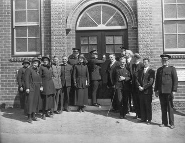
Photograph, Salvation Army Citadel Official Opening December 1934
Salvation Army Citadel Opening 1934. People in front of Citadel. Front Row from Left Mrs. Wilkinson, Mrs. Haines, Capt. Morris, Brig. Smalley, Col. Henry Mrs. Maxwell, Comm. Maxwell, Cr. Freeland, (Mayor), Col. Haines, Cr. R. McCracken, Rev. Ewin, Rev. Graham, Mr. Sharpley, Major Wilkinson. Black and white photograph of a group of people in uniform at an entrance to a brick building. The man in the center of the group appears to be opening the door to the building.. W.J. Chapman Photo artist Stawell. Col. A. Henry, Commissioner Maxwell, Col. W. Haines, Brig. F. Smalley, Mr. S. Freeland, Mayor of Stawell, Mr. R McCracken, Capt. F. Morris, Mrs. Col Haines, Mrs. Major Wilkinson, Town Clerk Mr. Sharpley, Major F. Wilkinson.stawell religion -
 Clunes Museum
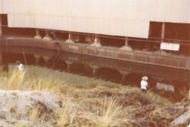
Photograph, PORT PHILLIP MINE
BLACK AND WHITE PHOTOGRAPH - SECTION PORT PHILLIP MINE. FLOOD WATER SURROUNDING BASE OF BUILDINGS R. MATHER BUILDING VISIBLEphotographs, mining, port phillip mine -
 Lakes Entrance Historical Society
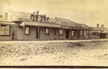
Photograph - Kiora House, 1920c
Also copy enlargement 12 cm x 19 cm Kiora House was purchased by Mrs C Beveridge from Mrs Begg. (Original building, A Murray's store, then Barkes store, before Barkes built near Post Office). House to the left purchased later, balcony built over veranda, this place removed and demolished for family home to be built later.Sepia toned photograph of Kiaora House. Houses on the left and the right. Sandy or Gravel roadway in front of building. Sand at the lake front in foreground of photo. People standing on upper balcony. Lakes Entrance VictoriaKiaora Housearchitecture, township, tourism, room display, local history -
 Mt Dandenong & District Historical Society Inc.
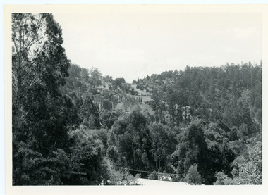
Photograph, View From Doughty's Road 1974
John Lundy-Clarke grew up in the Kalorama/Mt Dandenong area and later in life (1972-74) began to write a comprehensive history of the area working from an original settlement map in an effort to cover all areas. This photograph shows approximately the same area as photograph number KAL0193 but is taken 60 years later. The trees have grown much taller and the buildings changed. On the site of the Paynter house 'Iona' there is now the 'Yosemite' (Villa Toscana) accommodation. The pavilion in the centre of the photo is the site of 'Kalorama', home of early pioneer Isaac Jeeves. The photograph is taken looking up towards The Gap (FiveWays).Black and white photograph showing a forested area with clear sites. Roofs of buildings can be clearly seen. Handwritten inscription on reverse by John Lundy-ClarkeView from near Doughty’s Rd looking north up valley to Kalorama Gap in Jan 1973. Tiny roof in centre is pavilion on site of “Kalorama”. Long roof to its left is Yosemite Motel on site of “Iona”.paynter, kalorama, iona, yosemite, villa toscana, five ways, the gap -
 Charlton Golden Grains Museum Inc
Photograph, High St Charlton, east end, southside c. 1987, c.1987
Cricket Club Hotel established 1875, rebuilt as a two storey building 1935. Photograph part of the Shire of Charlton streetscape 1987Colour photograph looking west along High St. Cricket Club Hotel on the other side of the road with a large tree in front of the building. Blue and white signage for Steve Hill Ford further along with two palm trees at the front. Cars parked along both sides of the street. A person riding a bike toward the photographer.cricket club hotel, high st charlton, charlton, business, industry -
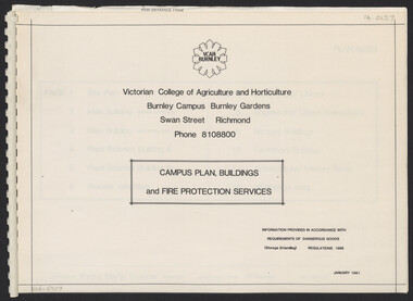 University of Melbourne, Burnley Campus Archives
Plan, Campus Plan, Buildings and Fire Protection Services
site plan, buildings, administration building, plant science laboratories, quad, library, student amenities building, engineering, urban horticulture, nursery -
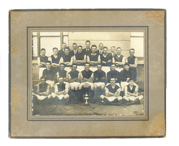 Tarnagulla History Archive
Tarnagulla Football Club Premiership team 1931 (Williams copy), Tarnagulla Football Club Premiership team 1931, 1931
Murray Comrie Collection. The players are posed in front of Tarnagulla Town Hall (also known as Burstall Hall) in the main street of Tarnagulla. The building has since been demolished.Mens football team posed in four lines in front of large building. All are wearing black tops and white shorts. Man at centre front is holding a football on which is painted PREMIER 1931. Probably taken in front of Tarnagulla Town Hall otherwise known as Burstall Hall (now demolished).Names of subjects and name 'L.Williams' handwritten on reverse.tarnagulla, sport, football, radnell, mcnamee -
 Kew Historical Society Inc
Plan, Melbourne & Metropolitan Board of Works : Borough of Kew : Detail Plan No.1302, 1910
The Melbourne and Metropolitan Board of Works (MMBW) plans were produced from the 1890s to the 1950s. They were crucial to the design and development of Melbourne's sewerage and drainage system. The plans, at a scale of 40 feet to 1 inch (1:480), provide a detailed historical record of Melbourne streetscapes and environmental features. Each plan covers one or two street blocks (roughly six streets), showing details of buildings, including garden layouts and ownership boundaries, and features such as laneways, drains, bridges, parks, municipal boundaries and other prominent landmarks as they existed at the time each plan was produced. (Source: State Library of Victoria)This plan forms part of a large group of MMBW plans and maps that was donated to the Society by the Mr Poulter, City Engineer of the City of Kew in 1989. Within this collection, thirty-five hand-coloured plans, backed with linen, are of statewide significance as they include annotations that provide details of construction materials used in buildings in the first decade of the 20th century as well as additional information about land ownership and usage. The copies in the Public Record Office Victoria and the State Library of Victoria are monochrome versions which do not denote building materials so that the maps in this collection are invaluable and unique tools for researchers and heritage consultants. A number of the plans are not held in the collection of the State Library of Victoria so they have the additional attribute of rarity.Original survey plan, issued by the MMBW to a contractor with responsibility for constructing sewers in the area identified on the plan within the Borough of Kew. The plan was at some stage hand-coloured, possibly by the contractor, but more likely by officers working in the Engineering Department of the Borough and later Town, then City of Kew. The hand-coloured sections of buildings on the plan were used to denote masonry or brick constructions (pink), weatherboard constructions (yellow), and public buildings (grey). The absence of buildings and or property in Kew facing the Yarra is the most notable feature of this plan. Walmer Street and its bridge stretched, then and now, from Studley Park Road to Victoria Street, Richmond. On the Richmond side of the Yarra, there was evidence in 1904 of industry (‘Wool shed’; Soap Works’) and entertainment (‘Skittle Alley’). In reality, another Plan (No.1303) shows Chinese Gardens bordering the Yarra on the Kew side and buildings in Young Street.melbourne and metropolitan board of works, detail plans, mmbw 1302, cartography -
 Port Melbourne Historical & Preservation Society
Photograph - Entrance to J Kitchen & Sons, Quinn Street, Port Melbourne, 1928
Black and white photograph of Quinn St entrance to J Kitchen and Sons showing brick entrance buildings with a three storey Administration Building behind the building on the left. Two trucks are parked in the entrance and four men standing beside the cars and buildings. Typed label on top right hand corner "Port Melbourne 1928"industry - manufacturing, built environment - industrial, transport - motor vehicles, workers, j kitchen & sons pty ltd -
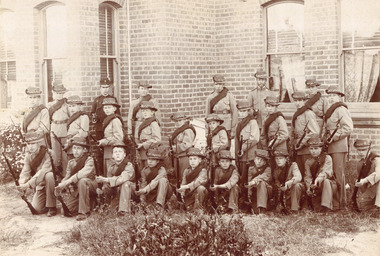 Surrey Hills Historical Society Collection
Photograph - Surrey College Cadet Corps, 1899, 1899
Surrey College was opened in early 1892 by Rev. Dr Frederick Darling who had been the first minister of the Presbyterian Church in Canterbury Road. He resigned this position to open the school which operated until 1908 with additional premises at 12 Vincent Street. The school had 40 boarders as well as day boys. Courses included algebra, euclid, history, typewriting, shorthand and drill. In the 1930s, Nethercourt Private Hospital took over the site. Later it became St Jude's Hospital. land in front of the building was subdivided off in the 1970s. The building is still extant as a private dwelling with York Street, Surrey Hills as the address. This is one of 3 photos donated by Susan Hobbs, whose grandfather Rev. George Edward Downton is thought to have been a student at the college. George E. Downton was born in Avoca in 1885. He was later a missionary in New Guinea and Secretary to the Australian Board of Missions in Adelaide. He died in 1926 or 1927. Sepia photo of 26 men and boys dressed in military uniform, many holding rifles. They are standing in front of a brick building with bay windows with blinds and curtains. There is a clump of foliage and grass in front of boys. "Surrey College - Surrey Hills / Principal: Rev Frdk. A. Darling, Melb. Univ./Cadet Corps, 1899." On the mount below the photo. Inscription on bottom right hand corner of photo: "Prepare for cavalry"schools, 1899, surrey hills, surrey college, rev frederick a darling, george edward downton, susan hobbs, union road, nethercourt hospital, st jude's hospital, 219-223 union road, cadet corps, 1890-1899 -
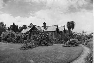 University of Melbourne, Burnley Campus Archives
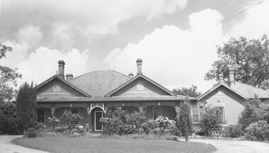
Photograph - Black and white print, Information Branch, Victorian Department of Agriculture, Principal's House, 1900-1909
Therefore the earlier comment about seated man would not be correct.2 copies black and white photograph. House and surrounding garden. Building is of stucco and timber, slate roof, 4 chimneys. The original sections of the house date from 1872. The seated gentleman on a bench in front of the house is probably Mr. E.E. Pescott.Reverse of larger copy, "from box the Garden/Land 1909." On reverse of smaller copy, "Photograph by Information Branch Victorian Department of Agriculture Ref. No. 1981(889-2.)" Further copy: handwritten on reverse, "Early 1900 certainly before 1909. Caption "Directors residence (1909) was a major feature of the garden. sadly it was demolished in 1980 now leaving none of the early college buildings outstanding." In different handwriting, "Principals House before 1909."e.e. pescott, principal's residence, principal's house -
 Federation University Historical Collection
Photograph - Black and White, Lydiard Street South, Ballarat, c2005, c2005
Photographs of buildings in Lydiard Street, Ballarat.ballarat, lydiard street south, craig's royal hotel -
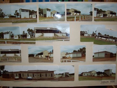 Glenelg Shire Council Cultural Collection
Photograph - Photograph, Montage - Hanlon Park, n.d
Glenelg Shire Council RecordsPhotographic Montage of buildings at Hanlon ParkFront: Bottom Right: Hanlon Park Pels Innes Neilson and Kosloff Pty. Ltd. Architects -
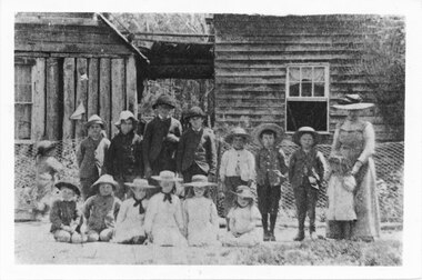 Halls Gap & Grampians Historical Society
Photograph - B/W, C 1890-1894
Students and teacher outside D'Altons House which was Silver Springs School Students are: Back Row L-R Syd Monk, Geo D'Alton, Donald and Harvey McDonald, Will D'Alton, Robert and James Wood, and L-R W Wood, Miss Alice Osborne, Front Row Sandy McDonald, T Wood, Emmy and Effie McDonald, Amy and Clare D'AltonStudents and teacher outside of school buildingeducation, schools, silver springs -
 Eltham District Historical Society Inc
Photograph, Montsalvat
Black and white photograph of buildings at Montsalvatmontsalvat, eltham, hillcrest avenue -
 Ringwood and District Historical Society
Photograph, Pines Hospital 1965
Black and white photograph of brick building.Typed below photograph, "The old 'Pines' hospital in Adelaide Street. 1965. Now Eastland site. Many older Ringwood residents born there." -
 Ringwood and District Historical Society
Photograph, Scots Church - Adelaide St., Ringwood. 1964
Black and white photograph - wooden building.Written below photograph, "Scots Church - Adelaide St.". Written on backing sheet, "1964 Pres. Church - Adelaide St." -
 Federation University Historical Collection
Photograph - Photograph - Colour, Ozone Hotel, Queenscliff, c1992, c 1992
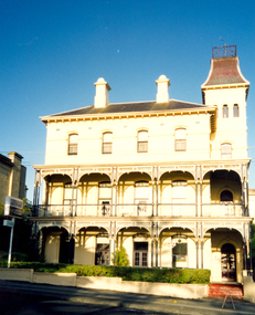
The Ozone at Queenscliff was the former house of the Baillieu family and originally called Baillieu House. It became one of the hotels in Queenscliff, operated by the family. It then became known as the Ozone Hotel after the Ozone Paddle steamer that brought many people to the area from Melbourne for their holidays. It was built in 1881 to the designs of William Ellis, and is now on both the Victorian Heritage Register and the Register of the National Estate.Photograph of a three storey building with tower. ozone hotel, queenscliff, william ellis, baillieu, ozone, baillieu house, paddle steamer, heritage, holidays, melbourne -
Glenelg Shire Council Cultural Collection
Photograph - Bromide Photograph - Concrete ramp next to building, n.d
Port of Portland Authority Archivesport of portland archives -
 Bendigo Historical Society Inc.
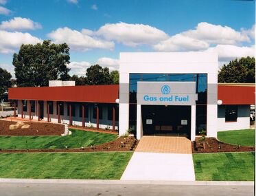
Photograph - CASTLEMAINE GAS COMPANY COLLECTION: PHOTO BUILDING
Photo of new Gas & Fuel Building.Kodakbusiness, retail, gas and fuel -
 Bendigo Historical Society Inc.
Photograph - COLOUR PHOTOGRAPH OF BUILDINGS AND TWO BOYS
COLOUR PHOTOGRAPH OF BUILDINGS AND two boys.photograph, person, male -
Port Melbourne Historical & Preservation Society
Postcard - Mission to Seamen, Port Melbourne, Alison Kelly, 1991
Postcard showing Mission to Seamen buildingMr J Coffey Box 255 Mansfieldreligion - anglican (holy trinity), local government - city of port melbourne, rev john coffey, alison kelly -
 Bendigo Historical Society Inc.
Photograph - GOLDEN SQUARE HIGH SCHOOL COLLECTION: ROOFING ON BUILDINGS
Photograph. GSHS, roofing on most buildings. -
 Bendigo Historical Society Inc.
Slide - BENDIGO VIEWS, Dec 1960
Slide. Bendigo Views. Bendigo buildings.slide, bendigo, bendigo views, bendigo views -
 Bendigo Historical Society Inc.
Slide - BENDIGO BUILDINGS
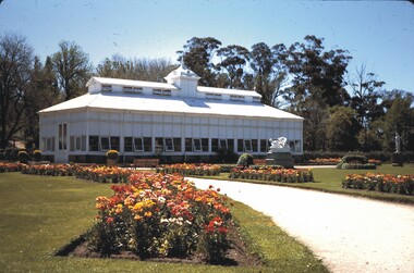
Slide. Bendigo Buildings . The Bendigo Baths.slide, bendigo, bendigo buildings etc.., bendigo buildings etc.. -
 Bendigo Historical Society Inc.
Slide - BENDIGO BUILDINGS & SCENERY, Oct 1968
Slide. Bendigo Buildings & Scenery. Conservatory.slide, bendigo, bendigo buildings & scenery., bendigo buildings & scenery. -
 Robin Boyd Foundation
Work on paper - External perspective, Neil Clerehan, 1945
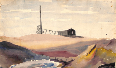
Robin Boyd met architect Neil Clerehan at the end of 1943 when they were both in the army. They worked together on Victorian Small Homes Service and were friends.Watercolour of a mining building in an outback landscape.On the reverse side "Neil Clerehan, 1945" on top left in blue pen, and "No 8" on bottom right in pencil.neil clerehan, robin boyd, ohm2022, ohm2022_29 -
University of Melbourne, Burnley Campus Archives
Document, Concept Proposal VCAH - Burnley, 1984
Proposal for Stage 1 building developmentvcah, burnley -
Clunes Museum
Souvenir - SOUVENIR FOLDER
PICTURIAL SOUVENIR FOLDER OF CLUNES BUILDINGSlocal history, documents, postcarf folder, souvenir folder of clunes buildings -
 Stawell Historical Society Inc
Photograph, Stawell High School Class Photo
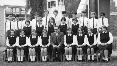
6975-11 Stawell High School Teacher Mr Mackay Students and Teacher in front of main BuildingStawell High School Form 1Beducation