Showing 3803 items matching " vehicles"
-
 Streatham and District Historical Society
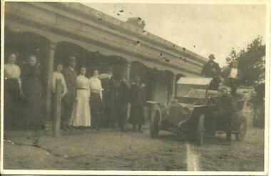
Picture, Streatham Hotel with people and motor vehicle
-
 Streatham and District Historical Society
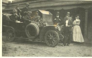
Picture, Harry Hawkins motor vehicle Streatham
-
 Eltham District Historical Society Inc
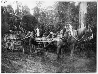
Photograph, W.G. Gray with trees from Kinglake, 1918c
W.G (William George) Gray, owner of Allwood Nurseries in Hurstbridge, with horses and cart laden with trees from Kinglake from where he also had a property raising stock. Shire of Eltham Councillor Gray donated English oak and oriental trees for the Anzac avenue at Hurstbridge planted in 1918. In 1922 he operated a well cultivated property of 64 cleared acres, 56 of which were under nursery healthy stock, principally apples, peaches, plums and cherries. In addition to 4 acres of potatoes. This photo forms part of a collection of photographs gathered by the Shire of Eltham for their centenary project book, "Pioneers and Painters: 100 years of the Shire of Eltham" by Alan Marshall (1971). The collection of over 500 images is held in partnership between Eltham District Historical Society and Yarra Plenty Regional Library (Eltham Library) and is now formally known as 'The Shire of Eltham Pioneers Photograph Collection.' It is significant in being the first community sourced collection representing the places and people of the Shire's first one hundred years.Digital imagesepp, shire of eltham pioneers photograph collection, hurstbridge, william george gray, kinglake, horse-drawn vehicle, trees -
 Eltham District Historical Society Inc
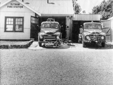
Photograph, George W. Bell, Eltham Fire Station, east side of Main Road, c.Jan 1964
The photograph was taken (and donated) by George W. Bell during the period of fire, c.1963-c.1964. The actual fire station was built c.1930 and was in use till c.1964 when a new fire station was built on the opposite side of Main Road. The building, originally situated just south of Arthur Street, on Main Road was ultimately relocated in 1970 to Research Park for use by the 1st Research Scout group. The site is now part of the current Coles supermarket and Eltham Village complex. The Fire Trucks are an Austin STU (small town unit) on the left and an Austin urban pumper on the right. This photo forms part of a collection of photographs gathered by the Shire of Eltham for their centenary project book,"Pioneers and Painters: 100 years of the Shire of Eltham" by Alan Marshall (1971). The collection of over 500 images is held in partnership between Eltham District Historical Society and Yarra Plenty Regional Library (Eltham Library) and is now formally known as 'The Shire of Eltham Pioneers Photograph Collection.' It is significant in being the first community sourced collection representing the places and people of the Shire's first one hundred years.Digital imageaustin stu fire truck, austin urban pumper, eltham, eltham fire brigade, fire station, fire truck, george w. bell, motor vehicles, shire of eltham pioneers photograph collection -
 Fire Services Museum of Victoria
SCANIA Combination Ladder Car 192
Among the last of these vehicles used by the MFB. The carrier vehicle is of 1990's origin, but the wooden ladder is far older. Combination Ladders evolved from the early Wheeled Escapes, used in the 19th Century. -
 Flagstaff Hill Maritime Museum and Village
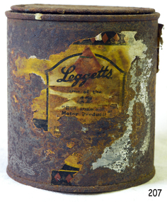
Container - Tin, Leggett Products Pty Ltd, 1966
The can is an example of a mid-20th-century car accessory cleaning product, a part of the evolution of vehicles.Tin; metal tin once containing Leggett's Hood Dressing. The label is marked with the product details and price. 15 Fluid Ounce Can."Motor Product" "4/6" (4 shillings and six pence)flagstaff hill, warrnambool, shipwrecked coast, flagstaff hill maritime museum, maritime museum, shipwreck coast, flagstaff hill maritime village, leggett's, can, tin, great ocean road, hood dressing, car bonnet, car cleaning -
 Marysville & District Historical Society
Photograph (Item) - Black and white photograph, Yarra Track Hotel, c1900
An early black and white photograph of a hotel along the Yarra Track.An early black and white photograph of a hotel along the Yarra Track. The Yarra Track is the former name of the gold fields road from Healesville to the Woods Point and Jordan Goldfields, in Victoria, Australia. A direct route via the Yarra River and the Great Divide was discovered by Rieck in September 1862 and became known as the Yarra Track. Early in 1863, the Victorian Government decided to construct a 193-kilometre (120 mile) road along the route. Its original width varied between 4 and 6 metres (12 and 20 feet), and was designed to accommodate horse-drawn vehicles. The Track involved the climbing of the Black Spur, descent into the Acheron Valley, and then through Marysville to the Cumberland where it followed the existing route. Unable to ascertain both the location and name of hotel.ARMSTRONG COLLECTION 42 STATION STREET/ SANDRINGHAM 3191/ TEL. (03) 9521 5442/ IAN M.L. ARMSTRONG OAMyarra track, healesville, wood's point, jordan goldfields, victoria, yarra river, great divide, reick, black spur, acheron valley, marysville, cumberland creek -
 Marysville & District Historical Society
Photograph (Item) - Black and white photograph, The "Scandinavians' - (Deserted), c1900
An early black and white photograph of The Scandinavian's Hotel and Boarding House along the Yarra Track.An early black and white photograph of The Scandinavian's Hotel and Boarding House along the Yarra Track. The Yarra Track is the former name of the gold fields road from Healesville to the Woods Point and Jordan Goldfields, in Victoria, Australia. A direct route via the Yarra River and the Great Divide was discovered by Rieck in September 1862 and became known as the Yarra Track. Early in 1863, the Victorian Government decided to construct a 193-kilometre (120 mile) road along the route. Its original width varied between 4 and 6 metres (12 and 20 feet), and was designed to accommodate horse-drawn vehicles. The Track involved the climbing of the Black Spur, descent into the Acheron Valley, and then through Marysville to the Cumberland where it followed the existing route.ARMSTRONG COLLECTION 42 STATION STREET/ SANDRINGHAM 3191/ TEL. (03) 9521 5442/ IAN M.L. ARMSTRONG OAMthe scandinavians', yarra track, healesville, wood's point, jordan goldfields, victoria, yarra river, great divide, reick, black spur, acheron valley, marysville, cumberland creek -
 Marysville & District Historical Society
Photograph (Item) - Black and white photograph, Camp Opposite The "Scandinavians', c1900
An early black and white photograph of a camp which was opposite The Scandinavian's Hotel and Boarding House along the Yarra Track.An early black and white photograph of a camp which was opposite The Scandinavian's Hotel and Boarding House along the Yarra Track. The Yarra Track is the former name of the gold fields road from Healesville to the Woods Point and Jordan Goldfields, in Victoria, Australia. A direct route via the Yarra River and the Great Divide was discovered by Rieck in September 1862 and became known as the Yarra Track. Early in 1863, the Victorian Government decided to construct a 193-kilometre (120 mile) road along the route. Its original width varied between 4 and 6 metres (12 and 20 feet), and was designed to accommodate horse-drawn vehicles. The Track involved the climbing of the Black Spur, descent into the Acheron Valley, and then through Marysville to the Cumberland where it followed the existing route.ARMSTRONG COLLECTION 42 STATION STREET/ SANDRINGHAM 3191/ TEL. (03) 9521 5442/ IAN M.L. ARMSTRONG OAMthe scandinavians', yarra track, healesville, wood's point, jordan goldfields, victoria, yarra river, great divide, reick, black spur, acheron valley, marysville, cumberland creek -
Marysville & District Historical Society
Document (Item) - Research Document, Judith Vimpani, William Cavanagh Farrell (1844-1901), 04-2020
An account of the life of William Cavanagh Farrell.An account of the life of William Cavanagh Farrell who was important to Marysville as his review in 1863 of the routes to Wood's Point led to the Yarra Track ascending the Black Spur and going on to what became the resort town of Marysville on the Steavenson River. The Yarra Track is the former name of the gold fields road from Healesville to the Woods Point and Jordan Goldfields, in Victoria, Australia. A direct route via the Yarra River and the Great Divide was discovered by Reick in September 1862 and became known as the Yarra Track. Early in 1863, the Victorian Government decided to construct a 193-kilometre (120 mile) road along the route. Its original width varied between 4 and 6 metres (12 and 20 feet), and was designed to accommodate horse-drawn vehicles. The Track involved the climbing of the Black Spur, descent into the Acheron Valley, and then through Marysville to the Cumberland where it followed the existing route.willaim cavanagh farrell, marysville, victoria, wood's point, yarra track, black spur, steavenson's creek, steavenson river, george theodore rieck -
Marysville & District Historical Society
Document (Item) - Research Document, Judith Vimpani, George Theodore Rieck (1833-pos 1884), 04-2020
An account of the life of George Theodore Rieck.An account of the life of George Theodore Rieck. The Yarra Track is the former name of the gold fields road from Healesville to the Woods Point and Jordan Goldfields, in Victoria, Australia. A direct route via the Yarra River and the Great Divide was discovered by Rieck in September 1862 and became known as the Yarra Track. Early in 1863, the Victorian Government decided to construct a 193 kilometre (120 mile) road along the route. Its original width varied between 4 and 6 metres (12 and 20 feet), and was designed to accommodate horse-drawn vehicles. The Track involved the climbing of the Black Spur, descent into the Acheron Valley, and then through Marysville to the Cumberland where it followed the existing route.george theordore rieck, marysville, victoria, james murphy, new chum creek, wood's point, gold mining, matlock, walhalla, yarra track -
Marysville & District Historical Society
Booklet (Item) - Information booklet, Artworkz Tourism, The Big Culvert, Unknown
An information booklet that was produced as a guide to The Big Culvert.An information booklet that was produced as a guide to The Big Culvert. The Big Culvert is a historic granite and bluestone arch along the Yarra Track, a major route to Melbourne through the 1800s. Built in 1870 and a major piece of infrastructure for its time, the heritage listed culvert allowed water to flow under often-flooded the road. The Yarra Track is the former name of the gold fields road from Healesville to the Woods Point and Jordan Goldfields, in Victoria, Australia. A direct route via the Yarra River and the Great Divide was discovered by Rieck in September 1862 and became known as the Yarra Track. Early in 1863, the Victorian Government decided to construct a 193-kilometre (120 mile) road along the route. Its original width varied between 4 and 6 metres (12 and 20 feet), and was designed to accommodate horse-drawn vehicles. The Track involved the climbing of the Black Spur, descent into the Acheron Valley, and then through Marysville to the Cumberland where it followed the existing route.the big culvert, yarra track, victoria, healesville, wood's point goldfields, jordan goldfields, black spur, acheron valley, cumberland valley -
Marysville & District Historical Society
Flyer (Item) - Information flyer, Artworkz Tourism, The Big Culvert, 26-03-2016
An information flyer that was produced as a guide to The Big Culvert.An information flyer that was produced as a guide to The Big Culvert. The Big Culvert is a historic granite and bluestone arch along the Yarra Track, a major route to Melbourne through the 1800s. Built in 1870 and a major piece of infrastructure for its time, the heritage listed culvert allowed water to flow under often-flooded the road. The Yarra Track is the former name of the gold fields road from Healesville to the Woods Point and Jordan Goldfields, in Victoria, Australia. A direct route via the Yarra River and the Great Divide was discovered by Rieck in September 1862 and became known as the Yarra Track. Early in 1863, the Victorian Government decided to construct a 193-kilometre (120 mile) road along the route. Its original width varied between 4 and 6 metres (12 and 20 feet), and was designed to accommodate horse-drawn vehicles. The Track involved the climbing of the Black Spur, descent into the Acheron Valley, and then through Marysville to the Cumberland where it followed the existing route.the big culvert, yarra track, victoria, healesville, wood's point goldfields, jordan goldfields, black spur, acheron valley, cumberland valley -
 Marysville & District Historical Society
Photograph (Item) - Black and white photograph, Unknown
A black and white photograph taken at the unveiling of the sign placed at The Big Culvert.A black and white photograph taken at the unveiling of the sign placed at The Big Culvert. The Big Culvert is a historic granite and bluestone arch along the Yarra Track, a major route to Melbourne through the 1800s. Built in 1870 and a major piece of infrastructure for its time, the heritage listed culvert allowed water to flow under often-flooded the road. The Yarra Track is the former name of the gold fields road from Healesville to the Woods Point and Jordan Goldfields, in Victoria, Australia. A direct route via the Yarra River and the Great Divide was discovered by Rieck in September 1862 and became known as the Yarra Track. Early in 1863, the Victorian Government decided to construct a 193-kilometre (120 mile) road along the route. Its original width varied between 4 and 6 metres (12 and 20 feet), and was designed to accommodate horse-drawn vehicles. The Track involved the climbing of the Black Spur, descent into the Acheron Valley, and then through Marysville to the Cumberland where it followed the existing route.Unveiling of sign/ at "Big Culvert" In front Max Cockerrell and - Rear: second back Geoff Pope R.H.S. rear: Nancy "/ Anne "the big culvert, yarra track, victoria, healesville, wood's point goldfields, jordan goldfields, black spur, acheron valley, cumberland valley -
 Marysville & District Historical Society
Photograph (Item) - Colour photograph, 20-09-2008
A colour photograph of the entrance to The Big Culvert.A colour photograph of the entrance to The Big Culvert. The Big Culvert is a historic granite and bluestone arch along the Yarra Track, a major route to Melbourne through the 1800s. Built in 1870 and a major piece of infrastructure for its time, the heritage listed culvert allowed water to flow under often-flooded the road. The Yarra Track is the former name of the gold fields road from Healesville to the Woods Point and Jordan Goldfields, in Victoria, Australia. A direct route via the Yarra River and the Great Divide was discovered by Rieck in September 1862 and became known as the Yarra Track. Early in 1863, the Victorian Government decided to construct a 193-kilometre (120 mile) road along the route. Its original width varied between 4 and 6 metres (12 and 20 feet), and was designed to accommodate horse-drawn vehicles. The Track involved the climbing of the Black Spur, descent into the Acheron Valley, and then through Marysville to the Cumberland where it followed the existing route.the big culvert, yarra track, victoria, healesville, wood's point goldfields, jordan goldfields, black spur, acheron valley, cumberland valley -
 Marysville & District Historical Society
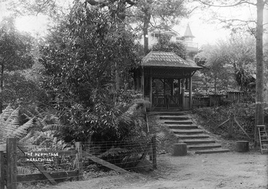
Photograph (Item) - Black and white photograph, John William Lindt, 1910
A digital copy of an early black and white photograph of the entrance gate to "The Hermitage" at Narbethong in Victoria.A digital copy of an early black and white photograph of the entrance gate to "The Hermitage" at Narbethong in Victoria. "The Hermitage" was built by photographer John William Lindt as a home and guesthouse in 1894. John Lindt had previously photographed the mountain scenery of the Black Spur and purchased 71 acres and subseqently built his home and guesthouse from where he continued his career. "The Hermitage had a garden designed by John Lindt's friend, Ferdinand von Mueller, who was at one stage the Director of the Melbourne Botanic Gardens. The garden featured New Guinea tree houses from which John Lindt made frequent panoramas of his property and the surrounding forest of towering mountain ash. Aged 81 Lindt died of heart failure during disastrous bushfires on 19 February 1926 at the Hermitage. He was survived by his wife Catherine who continued to run ‘The Hermitage’ guest house before she retired to the city. Visitors to the Hermitage alighted from horse-drawn vehicles and later motor coaches to enter the estate through the lich-gate in the background.the hermitage, john william lindt, narbethong, victoria, black spur, ferdinand von mueller, melbourne botanic gardens, new guinea, catherine lindt -
 Blacksmith's Cottage and Forge
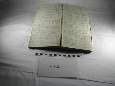
Book, Day, Day Book, 20 January 1920 to 27 April 1921
This book contains information relating to daily work conducted by Charles Edwards, Blacksmith, during period 20th January 1920 to 27 April 1921. It lists customer names, types of work done and costs involved. The written X indicates whether work was paid in full.This books contains historical information relating to peoples names and industries in the Bacchus Marsh district and the work performed for them by the blacksmith during the period mentioned. Most of work relates to shoeing horses, repairs to horse drawn vehicles, repairs to farm machinery/tools and some work on cars.Cardboard covers - green marbled design with black spine. Account type book with red ruled columns. Hand written names, jobs, charges and dates.On the inner cover - Mrs C Edwards, Main Street, Bacchus Marshbook, blacksmith, day, customers, clients, charles edwards -
 Gippsland Vehicle Collection
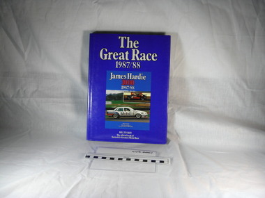
Book, Bill, Tuckey, The great race 1987/88, 1988 (exact)
Book with a bright blue hard cover, small insert photograph of two cars dust jacketbook, james, hardie, james hardie 1000 1987 1988, illustrations, james hardy 1000, hardie james -
 Gippsland Vehicle Collection
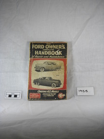
Book, FLOYD CLYMER, The FORD OWNER'S complete HANDBOOK of Repair and Maintenance, 1949 (exact)
This Ford Handbook is in good condition. This book covers at least 97% of the instructions necessary for servicing the 1950 and 1951 models.Repair and Maintenance book covering all models of ford including V8, "60" and FORD SIXOn page 106 of the handbook there is, in handwriting, CABLE OPERATED BRAKES, Spring, Colour & Position Guide. Hand drawn picture with details marking the layout and details of the spring, colour & position.electrical, steering, ford, engine, transmission, accessory, ford owners, car repair, v8, 60, ford six, repair and maintenance, ford engine, clutch, body, chassis, shockers, cooling system, fuel system, suspension, rear, axle, brakes, shock absorbers, rear axle -
 Gippsland Vehicle Collection
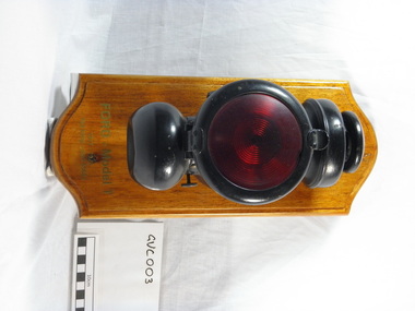
Tail-lamp, (exact); Post 28th August 1917 patent
Oil burning Tail-lamp for a (1917/23) model Ford T Model Motor Car in unused condition. Mounted on a varnished wooden block mount.Faintly engraved on top "Ford" Faintly engraved on bottom "PAT MAY 26 -14 PAT JUN 23 - 14 PAT NOV 23 - 15 PAT DEC 21 - 15 PAT NOV 7 - 16 PAT AUG 28 - 17" On front of Timber Mounting "Donated by Jim Dowton Sale FORD - Model T 1917 - 1923 Tailamp - part 6568x" On back of timber mounting "ON LOAN J.DOWTON SALE TAIL-LIGHT 1912 - 1919 T MODEL FORD"1920, 1918, 1919, 1917, 1923, ford, tail light, tail lamp, henry ford, t model, ford car, kerosene lamp, 1921, 1922, 6568x, part number 6568x, dowton -
Gippsland Vehicle Collection
Car Parts, Holden, Holden Car Parts and Starter Motor
Box of car parts and starter motor (holden)car, box, starter motor, holden -
Gippsland Vehicle Collection
Book, Reference Book
Reference Bookbook, reference -
Gippsland Vehicle Collection
Brackets, Shelving Brackets
Shelving Bracketsshelving, brackets -
Gippsland Vehicle Collection
Parts, Headlight Shells, 1930 (estimated)
Headlight Shells, 2 x teardropheadlight, shells, teardrop -
Gippsland Vehicle Collection
Magazines, F1 Magazines
Box of F1 magazinesbox, f1, magazines -
Gippsland Vehicle Collection
Machinery, Scribing Machine
Scribing Machinemachine, scribe, scribing -
Gippsland Vehicle Collection
Furnishings, Display Cabinets
Display Cabinetsfurniture, cabinet, display -
Gippsland Vehicle Collection
Spare Parts, Conrod
large conrod - bentlarge, conrod, bent -
Gippsland Vehicle Collection
Book / Magazine, Holden Book / Magazine
Holden Book / Magazinebook, holden, magazine