Showing 7077 items
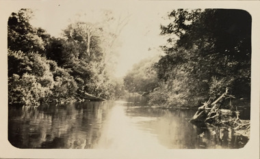
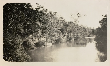
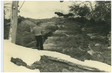
matching snowy-river
-
 Tatura Irrigation & Wartime Camps Museum
Book, State Rivers and Water Supply Commission Annual Reports 1967 - 71
Old report from the State Rivers and Water Supply Commissionvictoria state rivers and water supply commission -
Tatura Irrigation & Wartime Camps Museum
Book, State Rivers and Water Supply Commission Annual Reports 1971 - 76
Old report from the State Rivers and Water Supply Commissionvictoria state rivers and water supply commission -
Tatura Irrigation & Wartime Camps Museum
Book, State Rivers and Water Supply Commission Annual Reports 1976 - 79
Old report from the State Rivers and Water Supply Commissionvictoria state rivers and water supply commission -
Tatura Irrigation & Wartime Camps Museum
Book, State Rivers and Water Supply Commission Annual Reports 1979 - 82
Old report from the State Rivers and Water Supply Commissionvictoria state rivers and water supply commission -
Tatura Irrigation & Wartime Camps Museum
Letter - Camp 13 History, Cattanach Canal History Residents of Camp 13 Murchison During Period 1952 - 1956
3 Typed pages stapled at top left corner, type colour is purple. Also a handwritten post script on last page. non-fiction -
 Tatura Irrigation & Wartime Camps Museum
Photograph, State Rivers & Water Supply Commission Office
State Rivers & Water Supply Commission Office, Casey Street,photograph, people -
 Malmsbury Historical Society
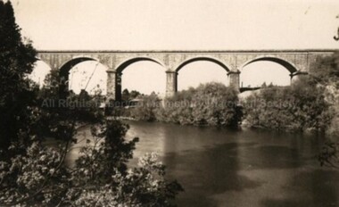
Postcard (Item), "Postcard Of The Viaduct Malmsbury, Rose Series P4159", Malmsbury c1923
Associated with - Rose Series P4159 Buildings - "Viaduct, Coliban River" -
 Port Fairy Historical Society Museum and Archives
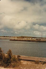
Photograph
Martin's Point from battery hill side of Moyne riverColoured photograph of Martins Point with people fishing on the bankmartins point, moyne river, fence, signal -
 Port Fairy Historical Society Museum and Archives
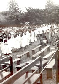
Photograph
St John’s choir processing toward the river Blessing of the FleetBlack and white photograph St John’s choir in white robes with wide collars and mortar board style hats, wooden benches in forgroundevents, civil, ceremony, choir, st johns, blessing of the fleet, moyne river -
Whitehorse Historical Society Inc.
Map - WW1 Trench map, Belgium collected by C H Honybun, Belgium WW1 map, Aug 1917
WW1 map of Belgium Edition 1. Sheet 28 S.W. and S.E. with trenches in red around the towns of Comines and Warnetonnon-fictionWW1 map of Belgium Edition 1. Sheet 28 S.W. and S.E. with trenches in red around the towns of Comines and Warnetonworld war 1914 - 1918, maps -
 Ballan Shire Historical Society
Map - Map. Shire of Ballan, Shire of Ballan
This is a fairly comprehensive map of the former Shire of Ballan which is now amalgamated into the Shire of Moorabool.A black and white map of the Shire of Ballan showing major roads, rivers, towns, settlements, State parks and forests and land subdivisions. It appears to be a copy of the original as no dates or maker or printer appear on the map. There is a scale of 2 miles to 1 inch.gordon, ballan, bungal, kerrit bareet, borhoneyghurk, bungeeltap, ballark, yaloak, gorong, beremboke, wallace, ingliston, hunterston, millbrook, bradshaw, myrniong, blackwood, moorarbool, greendale, bayup, trentham, bullarto, korweinguboora, glenlyon, bolwarra -
 Port of Echuca
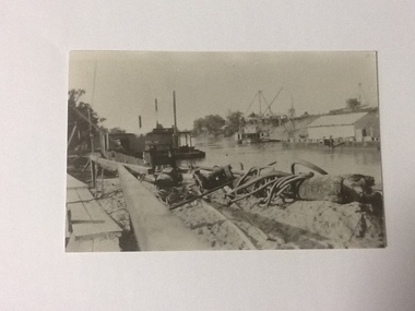
Black and white photograph, Approx 1980
Scene depicted is believed to have been the Euston Lock. It shows various pieces of equipment in the foreground , with a pontoon names Bream on the left bank with a paddle steamer, sheds and cranes in the distance on the right hand side of the photograph. Original photograph from the Price collection. Historically and socially significant photograph depicting early 1920's life on the Murray river.Black and white photograph of river scene depicting , by the left bank a pontoon "Bream" and by the right bank a steamboat behind a shelter construction. There are various cranes on the right bank. Copy of an original photograph taken in the 1920s believed to at Euston Lock, N.S.W.In pencil on back: Price / believed to be Euston Lock.riverboats, paddle steamers, price collection -
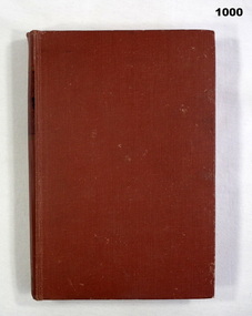 Bendigo Military Museum
Book, The Edge of the Sword, 1955
The Edge of the Sword - This book is the story of the Gloucestershire Regiment in the Imjin Battle and in captivity.Hard cover, red colour buckram, gold print own spine. 286 pages cut plain. Illustrated black and white photographs. End paper illustrated with map "Battle of the Imjin River" and "Routes followed by the author after capture"books, military history -
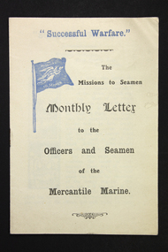 Mission to Seafarers Victoria
Flyer - Newsletter, Mission to Seafarers, "Successful Warfare" - The Missions to Seamen Monthly Letter to the Officers and Seamen of the Mercantile Marine, 1914-1918
The newsletter was published to address the Mercantile Marine primarily officers in the service. This is the number 19. The term "Merchant Navy" was coined in 1919 by King George V. So this foyer predates 1919.An unusual example of newsletter circulated by the Missions to Seamen (UK) during WW1. The aim may well have been to boost morale but clearly targeting Merchant mariners.Small paper and ink (2 colours, black and blue) 4 page stapled paper pamphlet/booklet. First page features some small black and white printed hand drawn graphics of a river mouth and a decorative angel or female. ww 1, mercantile marine service, mercantile marine, ww1, first world war, great war -
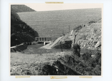 Kiewa Valley Historical Society
Photos - Kiewa Hydro Electric Scheme - Dartmouth, Official S.E.C.V. photos
Dartmouth Dam was built on the Mitta Mitta River in the 1970s. It is the highest dam in Australia (2022). It is the largest storage in Victoria (2022). It was built primarly for irrigation and urban use. The power station has the largest hydro-electric generator in Victoria (2022). -
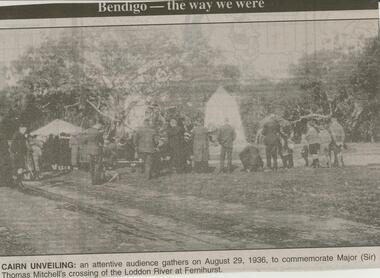 Bendigo Historical Society Inc.
Newspaper - JENNY FOLEY COLLECTION: CAIRN UNVEILING
Bendigo Advertiser ''The way we were'' from Monday, March 12, 2001. Cairn unveiling: an attentive audience gathers on August 29, 1936, to commemorate Major (Sir) Thomas Mitchell's crossing of the Loddon River at Fernihurst. The clip is in a folder.newspaper, bendigo advertiser, the way we were -
 Bendigo Historical Society Inc.
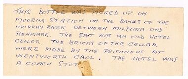
Document - BOTTLE FROM MOORNA STATION
White card with handwritten note: 'This Bottle was picked up on Moorna Station on the banks of the Murray River, between Mildura and Renmark. The spot was an old hotel cellar. The bricks of the cellar were made by the prisoners at Wentworth Gaol. The hotel was a coach Stop.document, bottle from moorna station, wentworth gaol. -
Bendigo Historical Society Inc.
Map - ROCHESTER WEST : COUNTY OF BENDIGO, 30-10-12
Map. Rochester West, County of Bendigo, Ballendella, Giggorra, Township of Rochester. Campaspe River. Photo-lithographed at the Department of Lands and Survey, Melbourne, by W.J. Butson 30-10-12. Price 1/-. (number 22 in map cupboard 1)W.J. Butson, Government Printer.map, bendigo, rochester west -
 National Vietnam Veterans Museum (NVVM)
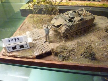
Model - Diorama
M113 APC Stopped on track near simple sapling river crossing. Twp Crew are in attendance, all hatches are open, soldier sitting in top hatch is holding a can of coke. Soldier at front of APC appears to be stretching, taking a break.m113, armoured personnel carrier, diorama, at rest -
 Bendigo Historical Society Inc.
Slide - PETER ELLIS COLLECTION: SLIDE, May 1970 - Jan 1972
Coloured slide transparency. Image is of a bush area. There is some machinery set into the ground in the foreground and some water from either a river or dam can be seen to the right. The words, Ruedin's Euc Oil Condenser are handwritten across the bottom border.Kodachrome Transparencyslide, bendigo, bendigo institute of technology -
Bendigo Historical Society Inc.
Photograph - HARRY BIGGS COLLECTION: BOTANICAL GARDEN BEACH, BRISBANE
Photograph. Harry Biggs Collection. A very small black & white photo of Botanical Garden Beach, Brisbane River. The photo is taken from what we now call Southbank. 5 boats can be seen in the foreground & the city in the background.place, land, public park, harry biggs collection, botanical garden beach, brisbane -
 Kew Historical Society Inc
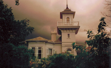
Photograph - 'Swinton', 23 Swinton Avenue, 2000
Swinton is of significance as one of the earliest examples of the use of the Italianate in Australian domestic architecture, and for the elegance of its design, particularly in the tower.Original colour positive photograph of the west elevation of Swinton, 23 Swinton Avenue, Kew. Facade facing Yarra River featuring tower and balcony with door and fanlight below. Projecting bay window at left. Rendered brick with slate roof. Ink on reverse: "Swinton - west elevation / Feb 2000"swinton, swinton avenue -- kew (vic.) -
 Kew Historical Society Inc
Photograph - Yarra at Kew, 1925
Henry Beater Christian (1886-1962) , was a descendant of one of the earliest settler families in Kew. Employed at the Kew Asylum as a 'public servant', he was a skilled amateur photographer, photographing numerous scenes in Kew and on his travels around Victoria. The majority of his photographs date from 1916 to 1929. His finest photographs are housed in two photograph albums. Digital copy of a photograph from page 4 of the 47-page photograph album containing 261 gelatinous silver images, loaned by Diane Washfold with permission given to digitise and hold a copy in our collection. This photograph is of the Yarra River at Kew."Yarra at Kew"henry beater christian (1886-1962), landscape photography, kew (vic.) — yarra river, christian-washfold collection, photograph albums -
 Kew Historical Society Inc
Photograph - Yarra River, Kew, 1924
Henry Beater Christian (1886-1962) , was a descendant of one of the earliest settler families in Kew. Employed at the Kew Asylum as a 'public servant', he was a skilled amateur photographer, photographing numerous scenes in Kew and on his travels around Victoria. The majority of his photographs date from 1916 to 1929. His finest photographs are housed in two photograph albums. Digital copy of a photograph from page 6 of the 47-page photograph album containing 261 gelatinous silver images, loaned by Diane Washfold with permission given to digitise and hold a copy in our collection. This is a photograph of the Yarra River at Kew."Yarra Rvr / Kew"henry beater christian (1886-1962), landscape photography, kew (vic.) — yarra river, christian-washfold collection, photograph albums -
 Falls Creek Historical Society
Photograph - Ray Meyer at Blair's Hut
MEYER COLLECTION - FALLS CREEK PHOTOS In 1947 a determined group of like-minded State Electricity Commission (SEC) staff including Ray Meyer, the chief surveyor of the Kiewa Hydro-Electric Scheme, had a common interest that revolved around the skiing potential of the snow-covered high plains which included what is now the resort of Falls Creek. The six SEC employees, Toni St Elmo, Ray Meyer, Jack Minogue, Lloyd Dunn, Adrian Ruffenacht and Dave Gibson (together with their families) banded together to secretly build a 'hut' that was the first ski lodge at Falls Creek. Using a road built in 1930s to gain access to Falls Creek, their hut project was carried out in secret as efforts by other skiers were blocked by H.H.C. Williams – the engineer in charge of the Hydro Scheme. In 1946 Ray Meyer made a trip to the Lands Office in Melbourne. He came away with a 99-year lease on three acres that was ideally suited for a hut designed by Lloyd Dunn. Adrian Ruffenacht (Design Engineer for the KHS) had suggested where the group should build because of easy access to a spring for water. Much of the building material required was scavenged from derelict huts on the high plains. Due to the need for secrecy, the determined group worked on the hut in the evenings and weekends to avoid detection. During the building period the group had met at Echidna Rock (now known as Eagle Rock) where Skippy St Elmo announced, "This is my favourite ‘Skyline’.” And so the first lodge in the area at Falls Creek Ski Resort came into existence. With the development of the International Poma in the 1970s, the Skyline Lodge, which was sited between the ski-lift’s pole one and pole two, was demolished. However, the legacy of Ray Meyer, Toni St Elmo, Jack Minogue, Lloyd Dunn, Adrian Ruffenacht and Dave Gibson and Skyline lives on in the vibrant atmosphere of Falls Creek Resort. The MEYER COLLECTION documents developments on the Kiewa Hydro Scheme and their life at Falls Creek from the mid 1930s to 1960s.This image is significant because it documents the activities of a prominent family in Falls Creek, VictoriaA photo of Ray Meyer at the Kiewa River near Blairs Hut. The original hut, built by cattlemen Frank and Tim Blair in 1923-24, was burnt down around 193o. It was rebuilt by Frank and his son in 1932. It is constructed of Alpine Ash.ray meyer, blairs hut, falls creek, victorian snowfields -
 Federation University Historical Collection
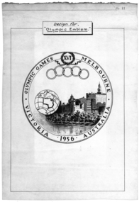
Poster, Design for "Olympic Emblem" Melbourne, 1956, c1956
The Olympic Games was held in Melbourne in 1956.White poster with black text and images. The poster shows an image of Melbourne buildings on the Yarra River, with a work globe featuring the outline of Australia. The poster also shows the olympic rings and relates to the 16th Olympic Games held in Melbourne in 1956.melbourne olympic games, melbourne, olympic games, poster -
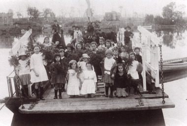 Lakes Entrance Historical Society
Photograph - Johnsonville Punt, 1921
Black and white photograph of the Johnsonville State School students posed on the Johnsonville Punt moored to the bank of the Tambo River. Many of the children are holding bunches of greenery, perhaps, indicating Arbor Day. Some adults also present. Johnsonville Victoria waterways, schools, transport -
 Bacchus Marsh & District Historical Society
Map, Maddingley Township, Parish of Parwan, 1880s
This map is dated Sept. 6th 1856. However places in the township of Maddingley which did not appear until the late 1880s such as the Bacchus Marsh Railway Station and line are shown on this map in their correct locations. This suggests the map has been derived from an earlier map. An earlier date of 1843 with a surveyor's name preceding it can also be seen on the map. The map is important because it indicates the location and dimensions of early but now discontinued use of land such as the showgrounds and police paddock and a site reserved for the Church of England which was not ultimately used for a permanent church. A single page paper map showing land allotments, streets, rivers, creeks, park lands, the railway line and Bacchus Marsh railway station in the township of Maddingley. The map is pasted into a bound volume containing 76 maps or plans in total. Bottom of Map: Surveyor-General's Office, Melbourne, Sept 6th, 1856bacchus marsh victoria maps, maddingley victoria maps, land use, maddingley victoria history -
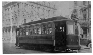 Melbourne Tram Museum
Negative, Wal Jack collection, mid 1920's
Black and White copy Photograph of U 204 in William St, at Collins St mid 1920's, with the destination of "M Br River". Has the Australian Mutual Prudential Bank? in the background. Photo is in the PRO H collection and the TAP collection.trams, tramways, u class, william st, maribyrnong river, collins st, tram 204 -
 Bacchus Marsh & District Historical Society
Map, Maddingley Township, Parish of Parwan, circa 1890s
Maddingley is a locality or township within the broader township area of Bacchus Marsh. This map is not dated. However features in Maddingley which appeared in the 1880s and 1890s are present in the map, These include the Bacchus Marsh Railway Station and the Bacchus Marsh Showgrounds. The main residential and commercial area of Maddingley is shown on this map in an area bounded by Bacchus Street, Barry Street, Griffith Street and Maddingley Road. Other streets visible are Franklin Street, Inglis Street, Labilliere Street, McCrae Street, Moore Street and part of Station Street.A single page paper map showing land allotments, streets, rivers, creeks, park lands, the railway line and Bacchus Marsh railway station in the township of Maddingley. The map is pasted into a bound volume containing 76 maps or plans in total. bacchus marsh victoria maps, maddingley victoria maps, land use, maddingley victoria history