Showing 9725 items
matching west
-
 Port Melbourne Historical & Preservation Society
Plan - North west elevation, Port Melbourne Town Hall, Engineering Department, City of Port Melbourne, 1915
Plan of new (1915) Town Hall, Port Melbourne (proposal ?). North west elevation, longitudinal section, front elevation, cross section A-A, section B-B.port melbourne town hall -
Port Melbourne Historical & Preservation Society
Document - Specification, Metalling and chanelling, Rouse Street between Esplanade East and Esplanade West, Engineering Department, Town of Port Melbourne, 14 Mar 1893
Specification for tram and road works in Rouse Street between Esplanades East and West and adjacent to Lagoon Loan Works 1893 plan 19; relates to plan 99.2.Signed by JJ Bartlett (Mayor) 14.3.1893engineering - roads streets lanes and footpaths, sandridge lagoon, transport - tramways, arthur victor heath, town clerks, james john bartlett, mayors -
Port Melbourne Historical & Preservation Society
Plan - Tram and roadworks, Rouse Street between Esplanade East and Esplanade West, Engineering Department, Town of Port Melbourne, Mar 1893
Plan for tram and road works in Rouse Street between Esplanades East and West and adjacent to Lagoon Loan Works 1893 plan 19; relates to specification 99.1Signed by JJ Bartlett (Mayor) 14.3.1893engineering - roads streets lanes and footpaths, sandridge lagoon, transport - tramways, arthur victor heath, town clerks, james john bartlett, mayors -
Port Melbourne Historical & Preservation Society
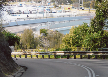
Photograph - Port Melbourne foreshore, Lyn Allison, Nov 1992
From a series of photos taken by Lyn Allison, then a Councillor of the City of Port Melbourne, to record the condition of Port Melbourne's beachesLasercopy of photo of the Port Melbourne foreshore looking west toward Station Pier with concrete beach wall in foreground. Taken by Cr Lyn Allison Nov 1992.'Nov 92'built environment - civic, natural environment - beaches and foreshore, lyn allison -
Port Melbourne Historical & Preservation Society
Photograph - Bay Street, Sandridge, 1891
Large black & white photograph from 1891 showing Bay Street from Graham Street to Beach Street and Railway Pier, west side of Bay Streetengineering, piers and wharves - station pier, piers and wharves - railway pier, bay street, graham street, beach street -
 Bendigo Historical Society Inc.
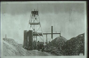
Slide - ALBERT RICHARDSON COLLECTION: SPECIMEN HILL, EAGLEHAWK
Slide. Specimen Hill, Eaglehawk, west of Sailor's Gully Road. Image taken about 1906. Poppet head, chimney stack, mullock heaps, ore bins.No. 22 on bottom of slidemine, gold, specimen hill (eaglehawk )., bendigo mines-jack hattam collection -
Bendigo Historical Society Inc.
Map - BENDIGO SHEET 2, No date visible
Map: Parish plan showing portion of Bendigo city, West from the Echuca rail line, showing lake weeroona ( number 136 in Map Cupboard 1)map, bendigo, city streets, bendigo sheet 2, bendigo streets -
Bendigo Historical Society Inc.
Map - BENDIGO (SANDHURST) PART, No date visible
Map: Parish plan showing an area North West from the McKenzie St. View St. corner to Long Gully ( number 220 in Map Cupboard 1)map, bendigo, parish plan, bendigo, long gully -
Tatura Irrigation & Wartime Camps Museum
Photograph, Heaphy's Whim-Inn Hotel
Heaphy's Whim-Inn Hotel; South West corner of Hogan Street and Dhurringile Road. Features a variety of patrons outside hotel; two horse-drawn buggies.tatura, buildings, historic, transport, horse, costume, male -
Williamstown High School
Inner West Music Festival 1994
The Finn Koren CollectionSingle sheet flyer advertising the Inner West Music Festival where Williamstown High School performed as the Wind Symphony. The event was at Sunshine North Primary School.williamstown high school, music, wind symphony, 1994, performances, inner west music festival -
 Hume City Civic Collection
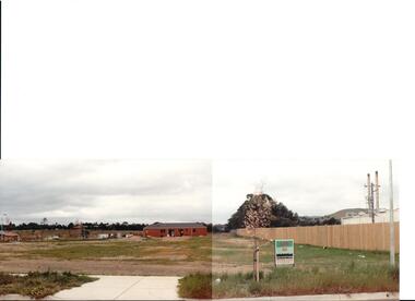
Photograph, early 1990s
The series of 5 photographs feature different views of the Woodlands housing development which opened up land bounded by Gap and Anderson Roads, Cornish Street and Elizabeth Drive in the early 1990s. It was a large housing development built close to Sunbury township.A coloured photograph of a new housing development taken in Anderson Road looking west towards Elizabeth Drive and the leisure centre. Some housing construction is in the middle distance.housing developments, anderson road, george evans collection -
 Whitehorse Historical Society Inc.
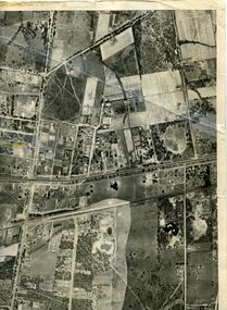
Map, Photo-map Ringwood A4A, 1945
Aerial photo covering approximately from Box Hill to Mitcham (West to East) and Springfield Road to Hawthorn Road (North to south).Aerial photo covering approximately from Box Hill to Mitcham (West to East) and Springfield Road to Hawthorn Road (North to south). Names of main roads inscribed.Aerial photo covering approximately from Box Hill to Mitcham (West to East) and Springfield Road to Hawthorn Road (North to south).aerial photographs, box hill, blackburn, nunawading, forest hill, mitcham -
 Rutherglen Historical Society
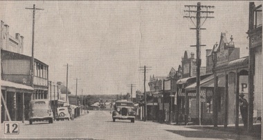
Image
One of a group of photographs of Rutherglen collected from magazines (Pix or People or Post), then pasted onto orange paper, date unknown. Main Street looking Westmain street, rutherglen -
 Whitehorse Historical Society Inc.
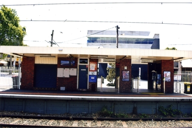
Photograph, Blackburn Railway Station, 2012
See NP3406Coloured photograph of the railway line near the Blackburn station, heading west towards the 'city Entry is from Railway Road and South Parade via a tunnel - 2012blackburn railway station, railways -
 Whitehorse Historical Society Inc.
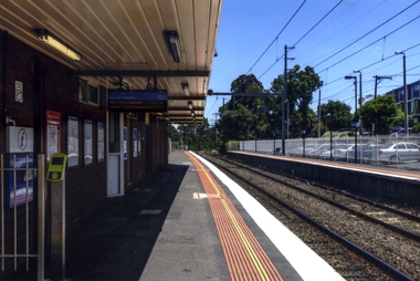
Photograph, Blackburn Railway Station
Coloured photograph taken of the southern side of the Blackburn Railway station looking west towards the city. Car park to the right is accessed from the Railway Road, Blackburnblackburn railway station -
 Whitehorse Historical Society Inc.
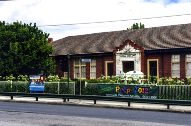
Photograph, Mitcham State School No 2904, 2012
See NP3945Coloured photograph of the Mitcham State School situated on the west side of Mitcham Road, opposite East Doncaster Road. Sign on the fence requesting 2012 prep enrolments.mitcham state school no 2904, state schools -
 Robin Boyd Foundation
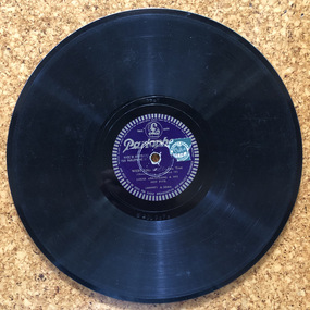
Audio - Recording, Parlophone
The Boyds purchased their record player and sound system from Thomas’s in Melbourne. Patricia Boyd (later Davies) was very interested in opera and was later appointed to the Board of the Australian Opera.West End Revue - Fox Trot. LP 33RPM vinyl, Catalogue Number: 401816 A 2964, 1 vinyl disk, plastic sleeve, no cover. Louie Armstrong.J. Albert & Son Royalty Stamp on both sideslp, sound recording -
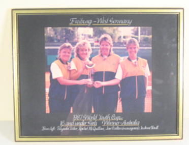 Tennis Australia
Photographic print, 1987
Framed colour photograph of the Australian team that won the 1987 World Youth Cup in Freiburg, West Germany. Materials: Ink, Photographic emulsion, Paper, Glass, Woodtennis -
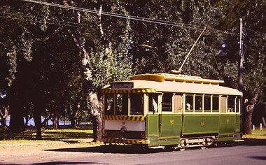 Ballarat Tramway Museum
Photograph - Digital image, Chris Phillips, c1970
Yields information about the tram track and trams in the Gardens area.Digital images of tram 18 in Wendouree Parade, with destination of Gardens via Sturt St West - possibly near Carlton St. Photo by Chris Phillips, c1970trams, tramways, gardens, wendouree parade, tram 18 -
Ballarat Tramway Museum
Newspaper, Trams Vs Buses, 17/09/1924 12:00:00 AM
Clipping from the West Australian, Perth, 17 September 1924, pg. 11, Ballarat Council introduces by-laws to control the completion between the tramways and bus companies.esco, ballarat public transport, bus competition, by laws, newspaper clippings, p pringle -
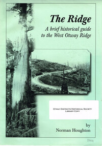 Otway Districts Historical Society
Book, The Ridge. Norman Houghton, 2008
The Ridge. A brief historical guide to the West Otway Ridge. Norman Houghton. Soft cover. iv, 16 p.; illus, map. Artwork and layout: Desktop Dynamics.otway ranges; norman houghton; crowes; lavers hill; macknott; stalker; pettit's siding; wyelangta; the tanks; kincaid; pile siding; weeaproinah; ferguson; buchanan; beech forest; olangolah; turtons track. -
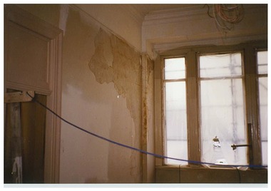 Queen Victoria Women's Centre
Photograph, c.1995/1996
Colour photograph. Level three facing north west into the lit and stair well where in 2015 is Casa house reception area. Taken during restoration inspection.building construction, historic buildings, cultural structures and establishments -
 Brimbank City Council Art Collection
Photograph, Robert Pointon, River Rocks, 1988
Local Significance. Part of the 1989 Hunt Club Exhibition.West bank Kororoit Creek looking east. Looking directly across the creek. Foliage in the immediate foreground. Creek in the midground, Stone embankment across the river. - AR0038photograph, kororoit creek, robert, pointon -
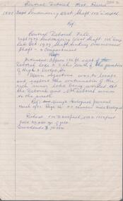 Bendigo Historical Society Inc.
Document - CENTRAL DEBORAH GOLD MINE: HISTORY OF CENTRAL DEBORAH
BHS CollectionEight foolscap handwritten pages of Central Deborah Gold Mine history. Written by Albert Richardson, the history also includes information on the Londonderry West shaft (1881).bendigo, mining, central deborah gold mine, central deborah gold mine -
Port Melbourne Historical & Preservation Society
Photograph - Large wooden framed colour panorama photograph of Port Melbourne waterfront, Alison Kelly
Framed photograph. Taken from Station Pier admin building approx 1990. Shows Engine Works; London Hotel; Swallow & Ariell; West Gate Bridgebuilt environment, commonwealth government engine works, london family hotel, swallow & ariell ltd, west gate bridge, engineering - bridges, natural environment - beaches and foreshore, piers and wharves -
Port Melbourne Historical & Preservation Society
Audio - Oral History, Pat Thomas, Janet Bolitho, 19 May 2003
Pat Thomas was interviewed by Janet Bolitho on 19.05.2003 at Pat's home at 75 Esplanade west, and discusses her life in Port Melbourne Duration 00:30:56domestic life, families, pat thomas -
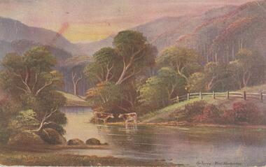 Bendigo Historical Society Inc.
Postcard - Alice McGregor Postcard Collection, 1900 - 1920
Alice McGREGOR Born: 1908; unknown parents. Possibly adopted by the Salter family? Electoral Roll 1936: Highland Terrace Kangaroo Flat. Alice Mary Salter and William Robert Salter living together; presumed to be sister and brother. William Robert Salter was killed in a MVA in Bendigo in 1937 aged 26. In Victoria in 1938, Alice Mary Salter married James Thomas McGregor (born Victoria 1917, died Victoria 1983, buried Fawkner Cemetery) Lived: 1968; 22 Wade Street Golden Square Alice McGregor Died: 1999 aged 91 at Anne Caudle Centre, Bendigo Buried: Kangaroo Flat Cemetery See additional research. Postcard Album of Alice McGregor contained 86 post cards.Postcard Album of Alice McGregor contained 86 post cards. See 1400. Colour painting of a rural scene of 2 cows beside the Yarra at West Warburton. Addressed to Miss H G Shatford, Black Rock, Via Sandringham, Victoria Sender J G D, Emu Park, W East Dated 25 Oct 1906 postcard, collector, alice mcgregor -
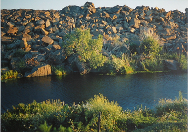
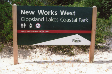 Lakes Entrance Historical Society
Photograph - New Works West, Randell, Peg, 2009
Date made January 2009Colour photograph showing signboard for New Works West, Gippsland Lakes Coastal Park, sign on sandy beach, thick scrub behind. Lakes Entrance Victoriasignage, historic site -
 Lakes Entrance Historical Society
Photograph - North Arm Bridge, 2008
Date made September 2008Colour photograph showing the new North Arm bridge opened 2000, taken from pathway besides Princes Highway at west end of Lakes Entrance, Victoria.bridges, waterways, roads and streets -
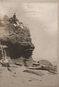 Lakes Entrance Historical Society
Photograph, HD Bulmer, Lakes Tyers Beach Victoria, 1915 1920 c
, erosion under cliff, cliff top intact. Lakes Tyers Beach VictoriaSepia toned photograph of west side of Red Bluff near Lake Tyers showing seven people on cliff top and two ladies seated on rock at beach environment, topography, beaches