Showing 2841 items matching " aerial"
-
 Moorabbin Air Museum
Book - AERIAL AGRICULTURE IN AUSTRALIA, DERRICK ROLLAND, 1996
... AERIAL AGRICULTURE IN AUSTRALIA......AERIAL AGRICULTURAL ASSOCIATION OF AUSTRALIA LTD...Moorabbin Air Museum Moorabbin Airport 12 First Street Moorabbin melbourne AERIAL AGRICULTURE IN AUSTRALIA Book AERIAL AGRICULTURE IN AUSTRALIA DERRICK ROLLAND AERIAL AGRICULTURAL ASSOCIATION OF AUSTRALIA LTD ... -
 Bacchus Marsh & District Historical Society
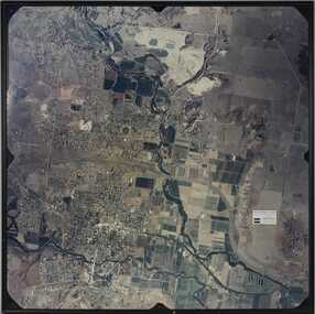
Photograph, Aerial image of Bacchus Marsh and Darley in 1994
... Aerial image of Bacchus Marsh and Darley in 1994...A whole of town and nearby area aerial image of Bacchus Marsh produced for display in the Arbee Real Estate Agency premises in Main Street, Bacchus Marsh....A large framed colour aerial photograph showing the township of Bacchus Marsh, the neighbouring smaller community of Darley, and the nearby areas of both places. ..."Bacchus Marsh - Darley. Aerial Photo 27 November, 1994. Presented by Arbee Real Estate "Professionals"'...Aerial image of Bacchus Marsh and Darley in 1994 Photograph ...A whole of town and nearby area aerial image of Bacchus Marsh produced for display in the Arbee Real Estate Agency premises in Main Street, Bacchus Marsh.A large framed colour aerial photograph showing the township of Bacchus Marsh, the neighbouring smaller community of Darley, and the nearby areas of both places. "Bacchus Marsh - Darley. Aerial Photo 27 November, 1994. Presented by Arbee Real Estate "Professionals"'arbee real estate agency bacchus marsh, aerial views bacchus marsh vic. -
 Buninyong & District Historical Society
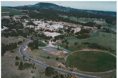
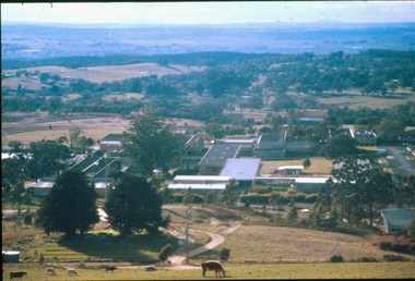
Photograph - Colour Photograph of Mt Helen Campus, Aerial view of University of Ballarat, Mt. Helen Campus c1991
... Aerial view of University of Ballarat, Mt. Helen Campus c1991...Aerial view Mount Helen Campus c1991...Mt. Helen Campus. Aerial view to Mt. Buninyong c. 1991...Helen Campus Tertiary Education Mount Buninyong Rural Development Mt. Helen Campus. Aerial view to Mt. Buninyong c. 1991 Aerial view Mount Helen Campus c1991 Aerial view of University of Ballarat, Mt. ...Mount Helen Campus in its later building stages before becoming the University of Ballarat in 1994The University of Ballarat was formed from a number of varying types of tertiary schools, the earliest being the School of Mines in 1870 and finally became a University in 1994 Aerial view Mount Helen Campus c1991Mt. Helen Campus. Aerial view to Mt. Buninyong c. 1991university of ballarat, mt. helen campus, tertiary education, mount buninyong, rural development -
 Camberwell Historical Society
Photograph, Camberwell Victoria, aerial view of the District, c. 1940
... Camberwell Victoria, aerial view of the District...Print of photograph with inscription 'Camberwell Victoria, aerial view of the District, c. 1940' ...Camberwell Victoria, aerial view of the District, c. 1940...Camberwell Historical Society 25 Inglesby Road Camberwell melbourne Camberwell Camberwell Victoria, aerial view of the District, c. 1940 Print of photograph with inscription 'Camberwell Victoria, aerial view of the District, c. 1940' Camberwell Victoria, aerial view of the District Photograph Photograph ...Print of photograph with inscription 'Camberwell Victoria, aerial view of the District, c. 1940' Camberwell Victoria, aerial view of the District, c. 1940camberwell -
4th/19th Prince of Wales's Light Horse Regiment Unit History Room
Mast Aerial Gear No 2 Mk II, Kit Aerial Vertical 34 Feet Steel (Aust), 1953 (case)
... Kit Aerial Vertical 34 Feet Steel (Aust)...A canvas carrying bag containing the mast sections, aerial base etc, complete with case containing No 1 antenna rods 'F'...Kits Aerial Z1/ZAA 0050, Bag Aerial Gear MkII ZA0437, Case Carrying ZA 1101...4th/19th Prince of Wales's Light Horse Regiment Unit History Room 4/19 PWLH Regiment, Building 78 Simpson Barracks Macleod melbourne Mast 34 foot antenna Kits Aerial Z1/ZAA 0050, Bag Aerial Gear MkII ZA0437, Case Carrying ZA 1101 A canvas carrying bag containing the mast sections, aerial base etc, complete with case containing No 1 antenna rods 'F' Kit Aerial Vertical 34 Feet Steel (Aust) Mast Aerial Gear No 2 Mk II MH & Co ...A canvas carrying bag containing the mast sections, aerial base etc, complete with case containing No 1 antenna rods 'F'Kits Aerial Z1/ZAA 0050, Bag Aerial Gear MkII ZA0437, Case Carrying ZA 1101mast 34 foot, antenna -
Federation University Historical Collection
Image, Aerial View of Ballarat
... Aerial View of Ballarat......aerial...Lithograph of an aerial view of Ballarat....Barker Library (top floor) Mount Helen goldfields Ballarat aerial Lithograph of an aerial view of Ballarat. ...Lithograph of an aerial view of Ballarat.ballarat, aerial -
 Ringwood and District Historical Society
Photograph, Aerial Views of Eastland Precinct, Ringwood, Victoria - circa 1990
... Aerial Views of Eastland Precinct, Ringwood, Victoria - circa 1990...Two colour aerial photographs overlooking commercial area of Ringwood centred on Eastland shopping precinct (prior to Stage 2 extension proposed to commence in 1992)....Aerial Photography by R.J. Moss....Ringwood and District Historical Society 125A Warrandyte Road Ringwood North melbourne Aerial Photography by R.J. Moss. Two colour aerial photographs overlooking commercial area of Ringwood centred on Eastland shopping precinct (prior to Stage 2 extension proposed to commence in 1992). ...Two colour aerial photographs overlooking commercial area of Ringwood centred on Eastland shopping precinct (prior to Stage 2 extension proposed to commence in 1992).Aerial Photography by R.J. Moss. -
 Federation University Historical Collection
Photograph, Aerial View of Mount Helen Campus, 1985
... Aerial View of Mount Helen Campus......aerial...Aerial views of Mount Helen Campus...Barker Library (top floor) Mount Helen goldfields Mount Helen campus aerial Aerial views of Mount Helen Campus Aerial View of Mount Helen Campus Photograph ...Aerial views of Mount Helen Campusmount helen campus, aerial -
Federation University Historical Collection
Photograph, Aerial View of the Mount Helen Campus, 1983
... Aerial View of the Mount Helen Campus......aerial...Aerial view of the Mount Helen Campus...Barker Library (top floor) Mount Helen goldfields mount helen campus aerial Aerial view of the Mount Helen Campus Aerial View of the Mount Helen Campus Photograph ...Aerial view of the Mount Helen Campusmount helen campus, aerial -
Federation University Historical Collection
Photograph, Ballarat School of Mines Aerial View, c1982
... Ballarat School of Mines Aerial View......aerial...Aerial view of the Ballarat School of Mines campus....Barker Library (top floor) Mount Helen goldfields Ballarat school of mines aerial Aerial view of the Ballarat School of Mines campus. ...Aerial view of the Ballarat School of Mines campus.ballarat school of mines, aerial -
Tatura Irrigation & Wartime Camps Museum
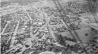
Photograph, Aerial of Tatura 1930, 1930
... Aerial of Tatura 1930...Early aerial photograph of township of Tatura. Main buildings and street can be seen. ...on back: aerial photo of Tatura 1930....Hampton. on back: aerial photo of Tatura 1930. Black and white photograph taken from a small plane of township of Tatura Aerial of Tatura 1930 Photograph ...Early aerial photograph of township of Tatura. Main buildings and street can be seen. Copied by W. Purcell. Original held by donor A. Hampton.Black and white photograph taken from a small plane of township of Taturaon back: aerial photo of Tatura 1930. -
Dandenong & District Historical Society
Document - Aerial Taxis, Articles Concerning Aerial Taxis
... Articles Concerning Aerial Taxis...Aerial Taxis, Newspaper Article, History...Articles concerning Aerial Taxis...Aerial Taxis, Newspaper Article, History Articles concerning Aerial Taxis Articles Concerning Aerial Taxis Document Aerial Taxis ...Aerial Taxis, Newspaper Article, History -
 Federation University Historical Collection
Photograph, Aerial Views of Mount Helen Campus, late 1988
... Aerial Views of Mount Helen Campus......aerial...Four aerial views of Mount Helen Campus...Barker Library (top floor) Mount Helen goldfields mount helen campus buildings aerial Four aerial views of Mount Helen Campus Aerial Views of Mount Helen Campus Photograph ...Four aerial views of Mount Helen Campusmount helen campus, buildings, aerial -
Federation University Historical Collection
Photograph, Aerial View of Mount Helen Campus
... Aerial View of Mount Helen Campus...aerial...Two aerial viewls of Mount Helen Campus...Barker Library (top floor) Mount Helen goldfields aerial mount helen campus buildings Two aerial viewls of Mount Helen Campus Aerial View of Mount Helen Campus Photograph ...Two aerial viewls of Mount Helen Campusaerial, mount helen campus, buildings -
 Whitehorse Historical Society Inc.
Photograph - Aerial photographs x 10, Miscellaneous Aerial Photos, 1966
... Miscellaneous Aerial Photos...1966 Aerial photographs...Ten aerial photographs in mainly the Eastern suburbs...Whitehorse Historical Society Inc. 2-10 Deep Creek Road Mitcham melbourne 1966 Aerial photographs Aerial photos eastern suburbs 1966 Ten aerial photographs in mainly the Eastern suburbs Miscellaneous Aerial Photos Photograph Aerial photographs x 10 ...1966 Aerial photographsTen aerial photographs in mainly the Eastern suburbsaerial photos, eastern suburbs, 1966 -
 Greensborough Historical Society
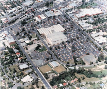
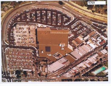
Aerial Photograph, Greensborough Plaza Aerial View, 1979c
... Greensborough Plaza Aerial View...Early aerial photograph of Greensborough Plaza, 1970....Colour photocopy of aerial survey, laminated...Greensborough Historical Society 34A Glenauburn Road Lower Plenty Lower Plenty melbourne Early aerial photograph of Greensborough Plaza, 1970. greensborough plaza Colour photocopy of aerial survey, laminated Greensborough Plaza Aerial View Aerial Photograph ...Early aerial photograph of Greensborough Plaza, 1970.Colour photocopy of aerial survey, laminatedgreensborough plaza -
 Vision Australia
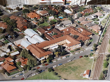
Photograph - Image, Aerial view of Elanora Nursing Home, 1980-1989
... Aerial view of Elanora Nursing Home...Aerial view of Elanora Nursing Home. Mair Street and the train line are clearly visible....Aerial photograph mounted on board...Vision Australia 454 Glenferrie Road Kooyong melbourne Aerial view of Elanora Nursing Home. Mair Street and the train line are clearly visible. association for the blind elanora home (brighton) Aerial photograph mounted on board Aerial view of Elanora Nursing Home Photograph Image ...Aerial view of Elanora Nursing Home. Mair Street and the train line are clearly visible.Aerial photograph mounted on boardassociation for the blind, elanora home (brighton) -
 Heidelberg Golf Club
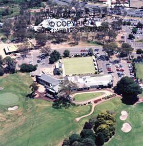
Photograph - Aerial Photograph, Heidelberg Golf Club, Aerial view of new clubhouse 1998, 1998
... Aerial view of new clubhouse 1998...Aerial of new clubhouse and surrounds at Heidelberg Golf Club 1998....Colour aerial photograph of golf course...Heidelberg Golf Club New clubhouse 1998 Aerial photographs Colour aerial photograph of golf course Aerial view of new clubhouse 1998 Photograph Aerial Photograph Heidelberg Golf Club HRTS Gargan photography ...Aerial of new clubhouse and surrounds at Heidelberg Golf Club 1998.Colour aerial photograph of golf courseheidelberg golf club, new clubhouse 1998, aerial photographs -
 Stawell Historical Society Inc
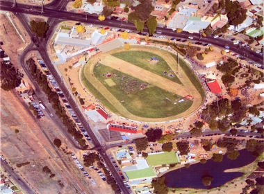
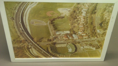
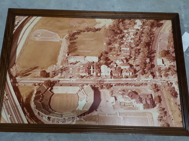
Photograph, Central Park -- Aerial Photo 2007 -- Coloured
... Central Park -- Aerial Photo 2007 -- Coloured...Three aerial photographs of the same view of Central Park taken in 2007. ...Three aerial photograph of a race oval in a town setting....Three aerial photographs of the same view of Central Park taken in 2007. ...Three aerial photographs of the same view of Central Park taken in 2007. Second aerial photograph (404.1) in Album 3 page 73 taken in 1995 at Easter. Three aerial photograph of a race oval in a town setting.Central Park - Easter (7.4.2007)stawell sport -
 Ballarat Heritage Services
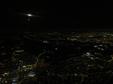
Photograph - Photograph - Colour, London by night aerial, 2017
... London by night aerial......aerial...Aerial photograph of London by night. ...Ballarat Heritage Services PO Box 2209 Bakery Hill Post Office goldfields London night england aerial lights Aerial photograph of London by night. ...Aerial photograph of London by night. london, night, england, aerial, lights -
 Stawell Historical Society Inc
Photograph - 1919 Aerial View Over Stawell, Main Street Area Looking toward Big Hill 1919-- Aerial View
... Main Street Area Looking toward Big Hill 1919-- Aerial View...Aerial View – Main Street Area 1919 Looking toward Big Hill...Aerial View over Stawell taken by R J McClure 1919...Stawell Historical Society Inc 46 Longfield St Stawell grampians Aerial View – Main Street Area 1919 Looking toward Big Hill stawell Aerial View over Stawell taken by R J McClure 1919 Main Street Area Looking toward Big Hill 1919-- Aerial View Photograph 1919 Aerial View Over Stawell ...Aerial View – Main Street Area 1919 Looking toward Big HillAerial View over Stawell taken by R J McClure 1919stawell -
 Federation University Historical Collection
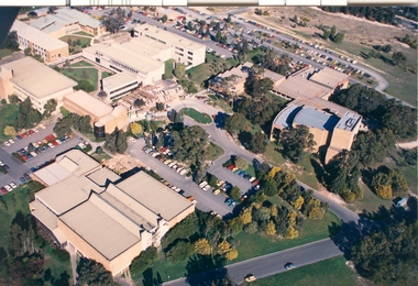
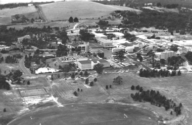
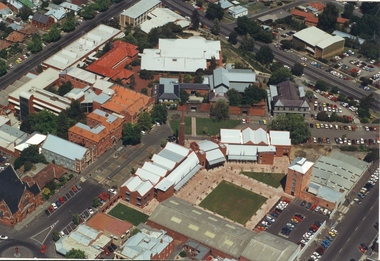
Photograph - Photograph - Black and White, Aerial view of Ballarat Institute of Advanced Education Mount Helen Campus, 1983, c1983
... Aerial view of Ballarat Institute of Advanced Education Mount Helen Campus, 1983......aerial...Aerial view of Federation University's Mount Helen Campus...Barker Library (top floor) Mount Helen goldfields The Mt Helen Campus is a Ballarat campus of Federation University Australia and was opened in 1970. mount helen aerial mount helen campus ballarat streetscape Aerial view of Federation University's Mount Helen Campus Aerial view of Ballarat Institute of Advanced Education Mount Helen Campus, 1983 Photograph Photograph - Black and White ...The Mt Helen Campus is a Ballarat campus of Federation University Australia and was opened in 1970. Aerial view of Federation University's Mount Helen Campusmount helen, aerial, mount helen campus, ballarat streetscape -
Federation University Historical Collection
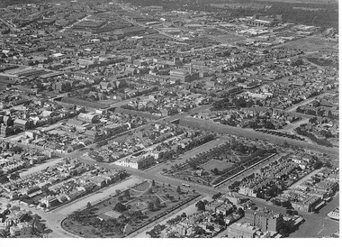
Photograph, Aerial View of the Ballarat School of Mines
... Aerial View of the Ballarat School of Mines......aerial...Aerial view of the Ballarat School of Mines showing the whole block surrounded by Lydiard Street South, Grant Street, Albert Street and Dana Street. ...Aerial View of the Ballarat School of Mines Photograph ...Aerial view of the Ballarat School of Mines showing the whole block surrounded by Lydiard Street South, Grant Street, Albert Street and Dana Street. ballarat school of mines, aerial -
 Greensborough Historical Society
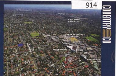
Photograph, Diamond Valley Leader, Greensborough: Aerial photograph, 21/05/2013
... Greensborough: Aerial photograph...This advertisement for a property at 95 Alexandra Street Greensborough includes several aerial photographs of Greensborough with the Ring Road, Watermarc and Greensborough Plaza marked....Colour advertisement including aerial photograph of Greensborough....An aerial view of Greensborough and surrounding areas in 2013. alexandra street greensborough plaza watermarc Colour advertisement including aerial photograph of Greensborough. ...This advertisement for a property at 95 Alexandra Street Greensborough includes several aerial photographs of Greensborough with the Ring Road, Watermarc and Greensborough Plaza marked.An aerial view of Greensborough and surrounding areas in 2013.Colour advertisement including aerial photograph of Greensborough.alexandra street, greensborough plaza, watermarc -
 Tatura Irrigation & Wartime Camps Museum
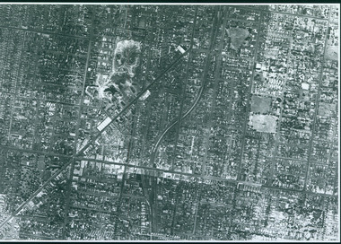
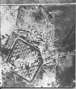
Photograph, Aerial photo of camp 3 1946
... Aerial photo of camp 3 1946...Aerial photograph, taken in 1946 of the Rushworth internment camp....Black and white aerial photograph of camp 3 Rushworth showing layout of the camp....Tatura Irrigation & Wartime Camps Museum 49 Hogan Street Tatura the-murray Aerial photograph, taken in 1946 of the Rushworth internment camp. aerial photo of camp 3 taken in 1946 Rushworth internment camp aerial photographs Victorian internment camps Black and white aerial photograph of camp 3 Rushworth showing layout of the camp. ...Aerial photograph, taken in 1946 of the Rushworth internment camp.Black and white aerial photograph of camp 3 Rushworth showing layout of the camp.aerial photo of camp 3, taken in 1946, rushworth internment camp, aerial photographs, victorian internment camps -
 Federation University Historical Collection
Photograph - Photograph - Colour, Aerial Views of Sites Relating to the University of Ballarat, c1998
... Aerial Views of Sites Relating to the University of Ballarat.......aerial...Five colour aerial photographs of sites associated with Federation University Australia. .1 & .2) Aerial views of the State Data Centre, Ballarat Technology Park .3) Aerial view of Mt Helen Campus, c1990 .4 and .5) Aerial View of Ballarat School of Mines Campus, 1998...Barker Library (top floor) Mount Helen goldfields The Ballarat Technology Park is associated with Federation University Australia. ballarat technology park state region data centre ballarat aerial view ballarat school of mines aerial aerial brewery building ballarat uniting church albert street Five colour aerial photographs of sites associated with Federation University Australia. .1 & .2) Aerial views of the State Data Centre, Ballarat Technology Park .3) Aerial view of Mt Helen Campus, c1990 .4 and .5) Aerial View of Ballarat School of Mines Campus, 1998 Aerial Views of Sites Relating to the University of Ballarat. ...The Ballarat Technology Park is associated with Federation University Australia. Five colour aerial photographs of sites associated with Federation University Australia. .1 & .2) Aerial views of the State Data Centre, Ballarat Technology Park .3) Aerial view of Mt Helen Campus, c1990 .4 and .5) Aerial View of Ballarat School of Mines Campus, 1998ballarat technology park, state region data centre, ballarat aerial view, ballarat school of mines aerial, aerial, brewery building, ballarat uniting church, albert street -
 St Kilda Historical Society
Ephemera - Postcard, City of Port Phillip, St Vincent Gardens and aerial view of Sth Melbourne circa 1900, 1900
... St Vincent Gardens and aerial view of Sth Melbourne circa 1900...Postcard black and white aerial view of South Melbourne (2 copies). ...St Vincent Gardens and aerial view of South Melbourne circa 1900. Historic gardens in the City of Port Phillip Postcard series celebrating the launch of the Royal Botanic Garden's Melbourne, 'Flora for Victoria' 1996....Postcard black and white aerial view of South Melbourne (2 copies). St Vincent Gardens and aerial view of Sth Melbourne circa 1900 Ephemera Postcard City of Port Phillip ...Foreground showing St Vincent Gardens. One of a series of postcards celebrating the launch of 'Flora for Victoria 1996', a project to celebrate the Royal Botanic Gardens of Melbourne`s 150th anniversary and the centenary of the death of its first director Baron Ferdinand von Mueller (1825 -1896)Postcard black and white aerial view of South Melbourne (2 copies). St Vincent Gardens and aerial view of South Melbourne circa 1900. Historic gardens in the City of Port Phillip Postcard series celebrating the launch of the Royal Botanic Garden's Melbourne, 'Flora for Victoria' 1996.south melbourne, st vincent gardens -
 Vision Australia
Photograph - Image, Association for the Blind offices in Kooyong aerial view
... Association for the Blind offices in Kooyong aerial view... Aerial view of Kooyong. The Kooyong Tennis Centre, Glenferrie Road, train station, Talbot Crescent, Monash Freeway and parklands are clearly visible. ...Aerial photograph in white frame...Few trees are lining the roadway around the sporting fields, the Glenferrie Road building has not expanded and the Blind Cricket pavilion is not yet built. association for the blind Kooyong Tennis Centre Aerial photograph in white frame Association for the Blind offices in Kooyong aerial view Photograph Image ...Aerial view of Kooyong. The Kooyong Tennis Centre, Glenferrie Road, train station, Talbot Crescent, Monash Freeway and parklands are clearly visible. Few trees are lining the roadway around the sporting fields, the Glenferrie Road building has not expanded and the Blind Cricket pavilion is not yet built. Aerial photograph in white frameassociation for the blind, kooyong tennis centre -
 Vision Australia
Photograph - Image, Association for the Blind offices in Kooyong aerial view
... Association for the Blind offices in Kooyong aerial view... Aerial view of Kooyong. The Kooyong Tennis Centre, Glenferrie Road, train station, Talbot Crescent, Monash Freeway and parklands are clearly visible. ...Aerial photograph in brown frame....Few trees are lining the roadway around the sporting fields, the Glenferrie Road building has not expanded and the Blind Cricket pavilion is not yet built. association for the blind Kooyong Tennis Centre Aerial photograph in brown frame. Association for the Blind offices in Kooyong aerial view Photograph Image ...Aerial view of Kooyong. The Kooyong Tennis Centre, Glenferrie Road, train station, Talbot Crescent, Monash Freeway and parklands are clearly visible. Few trees are lining the roadway around the sporting fields, the Glenferrie Road building has not expanded and the Blind Cricket pavilion is not yet built. Aerial photograph in brown frame.association for the blind, kooyong tennis centre -
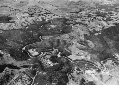 Eltham District Historical Society Inc
Photograph, Aerial view of Yarra River near Kangaroo Ground - Bend of Islands area
... Aerial view of Yarra River near Kangaroo Ground - Bend of Islands area...Aerial view of Yarra river at Bend of Islands; Henley Road on left in foreground...Sepia aerial view of Yarra river at Bend of Islands; Henley Road on left in foreground...Aerial view of Yarra river at Bend of Islands; Henley Road on left in foreground bend of isles kangaroo ground yarra river henley road Sepia aerial view of Yarra river at Bend of Islands; Henley Road on left in foreground Aerial view of Yarra River near Kangaroo Ground - Bend of Islands area Photograph ...Aerial view of Yarra river at Bend of Islands; Henley Road on left in foregroundSepia aerial view of Yarra river at Bend of Islands; Henley Road on left in foregroundbend of isles, kangaroo ground, yarra river, henley road