Showing 456 items matching " bulleen"
-
 Kew Historical Society Inc
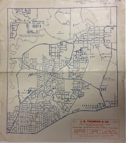
Map, Real Estate Map of Bulleen, Templestowe, Lower Templestowe, Doncaster, North Balwyn
... Real Estate Map of Bulleen, Templestowe, Lower Templestowe, Doncaster, North Balwyn......bulleen...A large undated printed map of Bulleen, Templestowe, Lower Templestowe, Doncaster, North Balwyn showing major and minor roads, waterways and proposed facilities in this area of Melbourne....Map of Bulleen, Templestowe, Lower Templestowe, Doncaster, North Balwyn used by JB Thomson & Co, Real Estate Agents, to identify and record land sales on these. ...Real Estate Map of Bulleen, Templestowe, Lower Templestowe, Doncaster, North Balwyn Map Map ...A large undated printed map of Bulleen, Templestowe, Lower Templestowe, Doncaster, North Balwyn showing major and minor roads, waterways and proposed facilities in this area of Melbourne.A useful if undated real estate map that allows viewers to compare current and historic aspects of these areasMap of Bulleen, Templestowe, Lower Templestowe, Doncaster, North Balwyn used by JB Thomson & Co, Real Estate Agents, to identify and record land sales on these. There are some markings on the plan indicating the location and price of lots.subdivision plans, bulleen, templestowe, lower templestowe, doncaster, north balwyn -
 Melbourne Tram Museum
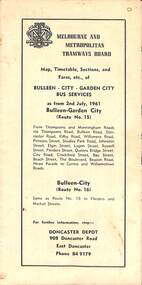
Map - Map, Timetable, Sections, and Fares, etc., of BULLEEN - CITY - GARDEN CITY BUS SERVICES
... Map, Timetable, Sections, and Fares, etc., of BULLEEN - CITY - GARDEN CITY BUS SERVICES...Map of the MMTB Bulleen - City - Garden City bus routes. ...Map, timetable & fares for Bulleen to City bus route...Melbourne Tram Museum 8 Wallen Road Hawthorn melbourne Map of the MMTB Bulleen - City - Garden City bus routes. MMTB buses Doncaster City Map, timetable & fares for Bulleen to City bus route Map, Timetable, Sections, and Fares, etc., of BULLEEN - CITY - GARDEN CITY BUS SERVICES Map Map, Timetable, Sections, and Fares, etc., of BULLEEN - CITY - GARDEN CITY BUS SERVICES ...Map of the MMTB Bulleen - City - Garden City bus routes. Map, timetable & fares for Bulleen to City bus routemmtb, buses, doncaster, city -
 Greensborough Historical Society
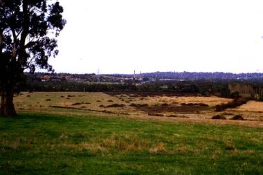
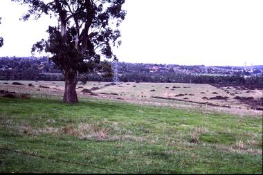
Slide - Photograph, John Ramsdale, Looking towards Bulleen brickworks: Slide 99, 1990
... Looking towards Bulleen brickworks: Slide 99...bulleen...Photograph shows a rural scene, looking towards Bulleen brickworks...Greensborough Historical Society 34A Glenauburn Road Lower Plenty Lower Plenty melbourne Photograph shows a rural scene, looking towards Bulleen brickworks Part of the John Ramsdale collection of slides and audio visual material. bulleen No maker's marks. ...Photograph shows a rural scene, looking towards Bulleen brickworksPart of the John Ramsdale collection of slides and audio visual material.Colour photograph scanned from slide.No maker's marks. No caption on slide.bulleen -
 Greensborough Historical Society
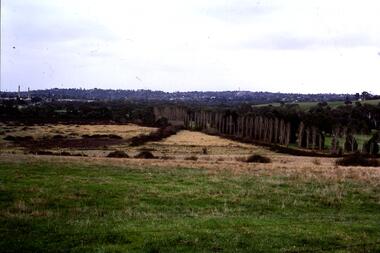
Slide - Photograph, John Ramsdale, Looking towards Bulleen brickworks; Slide 126, 1990s
... Looking towards Bulleen brickworks; Slide 126...bulleen...Photograph shows a rural view with paddocks and trees, looking towards Bulleen brickworks....Greensborough Historical Society 34A Glenauburn Road Lower Plenty Lower Plenty melbourne Photograph shows a rural view with paddocks and trees, looking towards Bulleen brickworks. Part of the John Ramsdale collection of slides and audio visual material. bulleen No caption. ...Photograph shows a rural view with paddocks and trees, looking towards Bulleen brickworks.Part of the John Ramsdale collection of slides and audio visual material.Colour photograph scanned from slide.No caption. Printed maker's mark on slide "Kodak Kodachrome Slide"bulleen -
 Greensborough Historical Society
Slide - Photograph, John Ramsdale, Looking towards Bulleen from Lower Plenty; Slide 115, 1990s
... Looking towards Bulleen from Lower Plenty; Slide 115...bulleen...Photograph shows a rural scene with gum tree and pylon, looking towards Bulleen from Lower Plenty....Greensborough Historical Society 34A Glenauburn Road Lower Plenty Lower Plenty melbourne Photograph shows a rural scene with gum tree and pylon, looking towards Bulleen from Lower Plenty. Part of the John Ramsdale collection of slides and audio visual material. bulleen lower plenty No caption. ...Photograph shows a rural scene with gum tree and pylon, looking towards Bulleen from Lower Plenty.Part of the John Ramsdale collection of slides and audio visual material.Colour photograph scanned from slide.No caption. Printed maker's mark on slide "Kodak Kodachrome Slide"bulleen, lower plenty -
 Kew Historical Society Inc
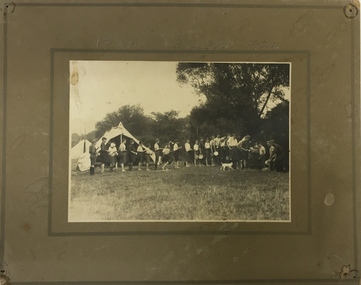
Photograph, Edwin Anderson, 1st Kew, Bulleen, 1924, 1924
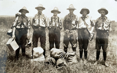
... 1st Kew, Bulleen, 1924......bulleen...During this period, the local Scouts were recorded as regularly camping at Bulleen, on the property of a friendly farmer. ...Kew Historical Society Inc Kew Court House 188 High Street Kew melbourne scouts - kew, 1st kew scouts scout camp 1920s bulleen On mounting board: 1st Kew Bulleeen 1924. ...A group of Scouts lining up for a meal. It would have been cooked by the ‘duty patrol’, with each patrol of Scouts taking turns at being the ‘duty patrol’. During this period, the local Scouts were recorded as regularly camping at Bulleen, on the property of a friendly farmer. As well as short overnight camps, the Scout Troop would have had a longer 8 to 10 day camp over the Christmas holidays every year. In the 1920s the Scouts often transported their camping gear by means of a hand-pulled ‘trek-cart’, which is no doubt why camping just down the road at Bulleen would have had appeal! On mounting board: 1st Kew Bulleeen 1924. On reverse: photographer's stampscouts - kew, 1st kew scouts, scout camp 1920s, bulleen -
 Whitehorse Historical Society Inc.
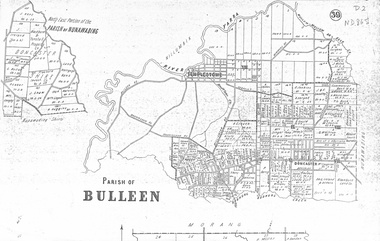
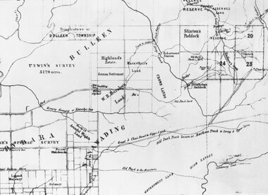
Map, Parish of Bulleen, 1892
... Parish of Bulleen...Copy of map of the Parish of Bulleen together with North-East portion of the Parish of Nunawading....Whitehorse Historical Society Inc. 2-10 Deep Creek Road Mitcham melbourne together with North-East portion of the Parish of Nunawading. Maps Parish of Bulleen Parish of Nunawading Copy of map of the Parish of Bulleen Copy of map of the Parish of Bulleen together with North-East portion of the Parish of Nunawading. ...Copy of map of the Parish of BulleenCopy of map of the Parish of Bulleen together with North-East portion of the Parish of Nunawading.Copy of map of the Parish of Bulleenmaps, parish of bulleen, parish of nunawading -
 Whitehorse Historical Society Inc.
map, Parish of Bulleen, Not dated
... Parish of Bulleen...Parish of Bulleen with North East portion of the Parish of Nunawading [n.d. 1890's?]...Whitehorse Historical Society Inc. 2-10 Deep Creek Road Mitcham melbourne shire of bulleen shire of nunawading land settlement A map on the parish of Bulleen. ...A map on the parish of Bulleen.Parish of Bulleen with North East portion of the Parish of Nunawading [n.d. 1890's?]A map on the parish of Bulleen.shire of bulleen, shire of nunawading, land settlement -
 Eltham District Historical Society Inc
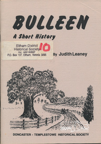
Book, Judith Leaney, Bulleen, a short history / by Judith Leaney ; illustrated by Irvine Green, 1991c
... Bulleen, a short history / by Judith Leaney ; illustrated by Irvine Green....bulleen...Bulleen, a short history / by Judith Leaney ; illustrated by Irvine Green. ...Paperback; 40 p. : ill. ; 21 cm.ISBN 094735302X [written on contents page] Judith Leaney 26/8/'91bulleen -
 Eltham District Historical Society Inc
Photograph, Fred Mitchell, Yarra Valley, Bulleen, 1983, 1983
... Yarra Valley, Bulleen, 1983......Bulleen...Eltham District Historical Society Inc 728 Main Rd Eltham melbourne fred mitchell collection 1983 Yarra Valley Bulleen Digital copy of colour photograph Yarra Valley, Bulleen, 1983 Photograph Fred Mitchell ...Digital copy of colour photographfred mitchell collection, 1983, yarra valley, bulleen -
 Eltham District Historical Society Inc
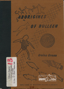
Book, Irvine Green, Aborigines of Bulleen : the history of the Aborigines of the Wurundjeri tribe who inhabited the area which became the city of Doncaster and Templestowe / Irvine Green, 1989
... Aborigines of Bulleen : the history of the Aborigines of the Wurundjeri tribe who inhabited the area which became the city of Doncaster and Templestowe / Irvine Green.......bulleen...Aborigines of Bulleen : the history of the Aborigines of the Wurundjeri tribe who inhabited the area which became the city of Doncaster and Templestowe / Irvine Green. ...Wurundjeri territorial groupings; subsistence; recreation of daily life; recreation; tribal law; kinship; childhood; religion and mythology; material culture, includes description of bark canoe manufacture; map of significant sites; culture contact and historyPaperback; 40 p. : ill., maps ; 23 cm.ISBN 0947353003aborigines, wurundjeri, social customs, stories, bulleen -
 Flagstaff Hill Maritime Museum and Village
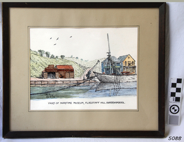
Painting - Watercolour, Alfred A Perry, Part of Maritime Museum, Flagstaff Hill. Warrnambool, 22-09-1979
... Perry / 31 Vera St. / Bulleen / 850-3367"...31 Vera Street, Bulleen, Melbourne, Victoria, Australia...Painting Watercolour Australia Victoria Bulleen Alfred A Perry ...This watercolour painting depicts a scene at Flagstaff Hill Maritime Village, showing some of the buildings and one of the vessels in the lake. The artist, Alfred A. Perry, lived in Victoria at the time of creating this painting. This painting is significant for its association with Flagstaff Hill Maritime Village. It shows a point in time, September 22nd, 1979, at which time the Ship's Chandler store was on the north of the lake. In 2022 the Ship's Chandler' is on the south of the lake and has been there for many years..Painting behind glass, framed in wood, black outline with watercolour. Depicting a scene of vessel at anchor on water, crane on wharf, buildings on track, valley and hills in background. Location is Flagstaff Hill Maritime Village. Artist is Alf Perry, painting dated 22-9-79.Signed "Alf Perry / 22-9-79" Handwritten on reverse "Alfred. A. Perry / 31 Vera St. / Bulleen / 850-3367"flagstaff hill, warrnambool, shipwrecked-coast, flagstaff-hill, flagstaff-hill-maritime-museum, maritime-museum, shipwreck-coast, flagstaff-hill-maritime-village, alf perry, watercolour, alfred perry, alfred a perry, flagstaff hill history, 1979, flagstaff hill village -
 Eltham District Historical Society Inc
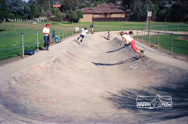
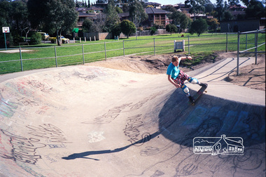
Photograph, The Snake Run, Bulleen Skatepark, Swanston Street Reserve, 96 Swanston Street, Bulleen, c.1985, 1985c
... The Snake Run, Bulleen Skatepark, Swanston Street Reserve, 96 Swanston Street, Bulleen, c.1985...Bullen Skatepark Skate Park Snake run Fuji 100 Roll of 35mm colour negative film, 2 strips The Snake Run, Bulleen Skatepark, Swanston Street Reserve, 96 Swanston Street, Bulleen, c.1985 Photograph ...One of the pioneering skateparks in Victoria.Roll of 35mm colour negative film, 2 stripsFuji 100bullen skatepark, skate park, snake run -
 Eltham District Historical Society Inc
Photograph, The Snake Run, Bulleen Skatepark, Swanston Street Reserve, 96 Swanston Street, Bulleen, c.1985, 1985c
... The Snake Run, Bulleen Skatepark, Swanston Street Reserve, 96 Swanston Street, Bulleen, c.1985...Eltham District Historical Society Inc 728 Main Rd Eltham melbourne One of the pioneering skateparks in Victoria. bullen skatepark skate park snake run Fuji 100 Roll of 35mm colour negative film, 2 strips The Snake Run, Bulleen Skatepark, Swanston Street Reserve, 96 Swanston Street, Bulleen, c.1985 Photograph ...One of the pioneering skateparks in Victoria.Roll of 35mm colour negative film, 2 stripsFuji 100bullen skatepark, skate park, snake run -
Whitehorse Historical Society Inc.
Map, Nunawading, c1850
... ...bulleen...Early map of Nunawading, Bulleen and part of Boroondara areas....Whitehorse Historical Society Inc. 2-10 Deep Creek Road Mitcham melbourne shire of nunawading bulleen boroondara Early map of Nunawading, Bulleen and part of Boroondara areas. ...Early map of Nunawading, Bulleen and part of Boroondara areas.Early map of Nunawading, Bulleen and part of Boroondara areas.Early map of Nunawading, Bulleen and part of Boroondara areas.shire of nunawading, bulleen, boroondara -
 Ringwood and District Historical Society
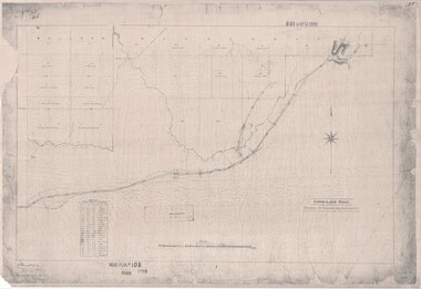
Map, Road Plan 108 - Gipps-land Road, Parishes of Bulleen and Warrandyte (Ringwood, Victoria) - 1855
... Road Plan 108 - Gipps-land Road, Parishes of Bulleen and Warrandyte (Ringwood, Victoria) - 1855...Road Plan 108 - Gipps-land Road, Parishes of Bulleen and Warrandyte (Ringwood, Victoria) - 1855 Map ...Surveyor's map of the part of the main road from Melbourne to Gippsland following "Barker's Track" south of Mullum Mullum or Deep Creek. Map references include Roman numerals marking distances measured in Links between trees at turns in the road.Submitted to the Surveyor General (Signed) July 2nd 1855. -
 Ringwood and District Historical Society
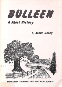
Book, Bulleen - A Short History, 1991
... Bulleen - A Short History...Autographed copy, signed by Judity Leaney 5/9/91. Bulleen - A Short History Book Judith Leaney Doncaster-Templestowe Historical Society ...Soft-cover book by Judity Leaney, Doncaster-Templestowe Historical Society. Autographed copy, signed by Judity Leaney 5/9/91.Acknowledgements: The Society wishes to thank Irvine Green, Ken Smith, The Veneto Club, Heide Gallery and Staff, Scott Brown and the Negri Family in the compilation of this book. -
 Ringwood and District Historical Society
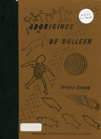
Book, Aborigines of Bulleen, 1989
... Aborigines of Bulleen...Ringwood and District Historical Society 125A Warrandyte Road Ringwood North melbourne Soft-cover book with indigenous artwork on brown cover with maps, drawings and photographs outlining the history of local indigenous people who inhabited the area which became the City of Doncaster and Templestowe. Aborigines of Bulleen Book ...Soft-cover book with indigenous artwork on brown cover with maps, drawings and photographs outlining the history of local indigenous people who inhabited the area which became the City of Doncaster and Templestowe. -
 Ringwood and District Historical Society
Map, Parish Map including Bulleen, Nunawading, and eventual site of Ringwood. c1855
... Parish Map including Bulleen, Nunawading, and eventual site of Ringwood. c1855...Parish Map including Bulleen, Nunawading, and eventual site of Ringwood. c1855 Map ...Black and white copy of part of Parish Map collection. Volume 3, Folio 105.Note on rear of backing sheet: "Ringwood is south of Lots 23 & 24, RHS. -
Whitehorse Historical Society Inc.
Map, Aborigines of Bulleen, n.d
... Aborigines of Bulleen...Map showing traces of Wurunngeri Tribe to be found in an area which became City of Doncaster and Templestowe, taken from history written by Irvine Green. Aborigines of Bulleen Map Map ...Map showing traces of Wurunngeri Tribe to be found in an area which became City of Doncaster and Templestowe, taken from history written by Irvine Green.Map showing traces of Wurunngeri Tribe to be found in an area which became City of Doncaster and Templestowe, taken from history written by Irvine Green.Map showing traces of Wurunngeri Tribe to be found in an area which became City of Doncaster and Templestowe, taken from history written by Irvine Green.aborigines, city of doncaster -
Whitehorse Historical Society Inc.
Map, Parishes of Bulleen, Boroondara, Prahran and Nunawading, 1850
... Parishes of Bulleen, Boroondara, Prahran and Nunawading...Allotments in the Parish surveyed by Lindsay Clarke 1850 (note by Robert Hoddle, surveys by Unwin, Elgar and Dendy indicated) Parishes of Bulleen, Boroondara, Prahran and Nunawading Map Map ...Photocopy of map and tables of corners of allotments.Photocopy of map and tables of corners of allotments. Note on verso: Nunawading, Boroondara, Prahran. Allotments in the Parish surveyed by Lindsay Clarke 1850 (note by Robert Hoddle, surveys by Unwin, Elgar and Dendy indicated)Photocopy of map and tables of corners of allotments. maps, parish of bulleen, parish of boroondara, parish of prahran, parish of nunawading, clarke, lindsay, hoddle, robert -
 Wonga Park Community Cottage History Group
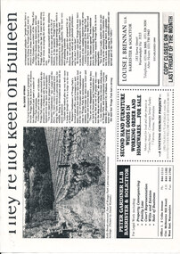
Newspaper (Item) - Cutting, Wonga Park: c. 1994 Warrandyte Diary cutting They're Not Keen On Bulleen
... Wonga Park: c. 1994 Warrandyte Diary cutting They're Not Keen On Bulleen...Wonga Park Community Cottage History Group Unit 1, 9 – 13 Old Yarra Road Wonga Park melbourne Wonga Park: c. 1994 Warrandyte Diary cutting They're Not Keen On Bulleen Newspaper Cutting ... -
 Kew Historical Society Inc
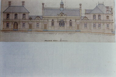
Slide - Architectural Drawing, Kew Public Offices, 1887
... After much deliberation, the location chosen was the junction of Bulleen and Cotham Roads. The buildings were designed by George Watson and John Henry Harvey, architects within the Department of Public Works (Victoria). ...BULLEEN ROAD ELEVATION...After much deliberation, the location chosen was the junction of Bulleen and Cotham Roads. The buildings were designed by George Watson and John Henry Harvey, architects within the Department of Public Works (Victoria). ...A civic campaign for new public offices developed in Kew in the 1880s. After much deliberation, the location chosen was the junction of Bulleen and Cotham Roads. The buildings were designed by George Watson and John Henry Harvey, architects within the Department of Public Works (Victoria). Building was commenced in 1887, and after one year, the buildings were opened. The Post Office was transferred to the new Commonwealth Government in 1901. The Police Station and Court House, sold by the Victorian Government to the City of Boroondara in 2007, are now a community cultural centre and performing arts venue.The buildings were listed on the Victorian Heritage Register Register (HO885) in 1991. They are historically and architecturally significant to the State Of Victoria because Watson and Harvey's designs exhibit diversity in integrating civil offices, they accommodate the apex of road junctions, and they demonstrate a departure from the contemporaneously favoured High Victorian Classical to the Queen Anne style in the design of civic buildings. 35mm colour transparency of an original plan by George Watson and John Henry Harvey, architects of the Department of Public Works (Victoria), in 1887 for New Public Offices at Kew. This plan was copied by the donor from an original held at the Commonwealth Archives in Brighton (Vic). The copy was made to illustrate a report that the donor made on ‘The functional planning design, building materials and construction methods of the Kew Post Office’ as part of course work at RMIT.BULLEEN ROAD ELEVATIONkew court house, kew police station, kew post office, architectural drawings, khs - slides, new public offices -- kew (vic.), architecture — queen anne style -
Whitehorse Historical Society Inc.
Document, Course Family, 2007
... ...Bulleen... With 'Thames' passenger lists, will of William James Course, Obituary of Sarah Ann Course, nee Bulleen and will of Susan Course nee Barker. ...With 'Thames' passenger lists, will of William James Course, Obituary of Sarah Ann Course, nee Bulleen and will of Susan Course nee Barker. ...Whitehorse Historical Society Inc. 2-10 Deep Creek Road Mitcham melbourne With 'Thames' passenger lists, will of William James Course, Obituary of Sarah Ann Course, nee Bulleen and will of Susan Course nee Barker. ...Births, deaths and marriages of the Course Family, who emigrated from Cambridgeshire, Eng. on the 'Thames' in 1855.Births, deaths and marriages of the Course Family, who emigrated from Cambridgeshire, Eng. on the 'Thames' in 1855. With 'Thames' passenger lists, will of William James Course, Obituary of Sarah Ann Course, nee Bulleen and will of Susan Course nee Barker. Research by Pat Richardson and Maureen KellyBirths, deaths and marriages of the Course Family, who emigrated from Cambridgeshire, Eng. on the 'Thames' in 1855.course family, bulleen, sarah ann, barker, susan, richards, emily, fankhauser, florence, tainton, joseph, barker, john, fankhauser, george henry -
 Whitehorse Historical Society Inc.
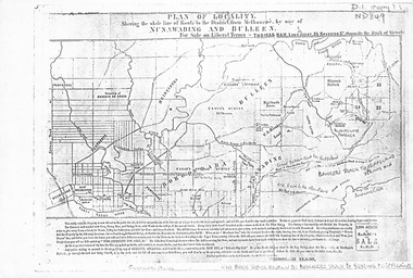
Map, Plan of locality, 1855-60?
... ...bulleen...'Plan of locality, showing the whole line of route to the district from Melbourne by way of Nunawading and Bulleen. 2,000 acres for sale... Thomas Ham, Land Agent [ 1855 - 60?]...Whitehorse Historical Society Inc. 2-10 Deep Creek Road Mitcham melbourne Copy of map held by Mrs Jean Uhl nunawading bulleen barkers track land sales 'Plan of locality, showing the whole line of route to the district from Melbourne by way of Nunawading and Bulleen. 2,000 acres for sale... ...'Plan of locality, showing the whole line of route to the district from Melbourne by way of Nunawading and Bulleen. 2,000 acres for sale... Thomas Ham, Land Agent [ 1855 - 60?]nunawading, bulleen, barkers track, land sales -
 Eltham District Historical Society Inc
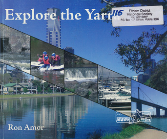
Book, Ron Amor, Explore the Yarra / Ron Amor, 2009
... Bulleen, Victoria, Australia ...Paperback; 101 p. : ill. ; 21 x 25 cm.ISBN 9780980308525yarra river, yarra river valley -
Whitehorse Historical Society Inc.
Map, Nunawading Shire, 1892
... One map (Blackburn) from north of Whitehorse Road to Highbury Road, 2nd map (Mitcham) Bulleen to south of Canterbury Road; 3rd map Whitehorse Road to Highbury Road....One map (Blackburn) from north of Whitehorse Road to Highbury Road, 2nd map (Mitcham) Bulleen to south of Canterbury Road; 3rd map Whitehorse Road to Highbury Road....One map (Blackburn) from north of Whitehorse Road to Highbury Road, 2nd map (Mitcham) Bulleen to south of Canterbury Road; 3rd map Whitehorse Road to Highbury Road. ...Photocopy of an enlargement of map of Shire of Nunawading showing landowners in 1892.Photocopy of an enlargement of map of Shire of Nunawading showing landowners in 1892. Covers Middleborough Road to Ringwood boundary. One map (Blackburn) from north of Whitehorse Road to Highbury Road, 2nd map (Mitcham) Bulleen to south of Canterbury Road; 3rd map Whitehorse Road to Highbury Road.Photocopy of an enlargement of map of Shire of Nunawading showing landowners in 1892. maps, shire of nunawading, blackburn, blackburn south, nunawading, forest hill, vermont, mitcham, vermont south -
 Eltham District Historical Society Inc
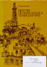
Book, City of Doncaster and Templestowe, History of Doncaster & Templestowe by Graham Keogh, 1975
... ...bulleen...History of the City of Doncaster and Templestowe, beginning with first settlers on Bulleen and Templestowe rivers, including gold seekers, general development 1900-1945, expansion, road problem, disaster of 1962, traffic problems, Warrandyte State Park, historical research. photos index...Eltham District Historical Society Inc 728 Main Rd Eltham melbourne History of the City of Doncaster and Templestowe, beginning with first settlers on Bulleen and Templestowe rivers, including gold seekers, general development 1900-1945, expansion, road problem, disaster of 1962, traffic problems, Warrandyte State Park, historical research. photos index doncaster templestowe bulleen warrandyte ISBN 0959948716 466 p. ...History of the City of Doncaster and Templestowe, beginning with first settlers on Bulleen and Templestowe rivers, including gold seekers, general development 1900-1945, expansion, road problem, disaster of 1962, traffic problems, Warrandyte State Park, historical research. photos index466 p.ISBN 0959948716doncaster, templestowe, bulleen, warrandyte -
Whitehorse Historical Society Inc.
Map, Directory Maps of the County of Bourke, 1892
... (i) Title Page, (ii) Preface (iii) Heading section of Map of Melbourne and Suburbs (iv) Parish of Bulleen - includes 'North - East portion of the Parish of Nunawading (v) Village of Burwood. ...Copies of:(i) Title Page, (ii) Preface (iii) Heading section of Map of Melbourne and Suburbs (iv) Parish of Bulleen - includes 'North - East portion of the Parish of Nunawading (v) Village of Burwood. ...Note: 107(a), 107(b), 107(c) are copies of the same set of sheets. Maps Parish of Bulleen Parish of Nunawading Burwood Copies of Directory maps:(i) Title Page, (ii) Preface (iii) Heading section of Map of Melbourne and Suburbs (iv) Parish of Bulleen - includes 'North - East portion of the Parish of Nunawading (v) Village of Burwood. ...Copies of Directory maps:(i) Title Page, (ii) Preface (iii) Heading section of Map of Melbourne and Suburbs (iv) Parish of Bulleen - includes 'North - East portion of the Parish of Nunawading (v) Village of Burwood. Note: 107(a), 107(b), 107(c) are copies of the same set of sheets.Copies of:(i) Title Page, (ii) Preface (iii) Heading section of Map of Melbourne and Suburbs (iv) Parish of Bulleen - includes 'North - East portion of the Parish of Nunawading (v) Village of Burwood. Note: 107(a), 107(b), 107(c) are copies of the same set of sheets.Copies of Directory maps:(i) Title Page, (ii) Preface (iii) Heading section of Map of Melbourne and Suburbs (iv) Parish of Bulleen - includes 'North - East portion of the Parish of Nunawading (v) Village of Burwood. Note: 107(a), 107(b), 107(c) are copies of the same set of sheets.maps, parish of bulleen, parish of nunawading, burwood -
 Scout Heritage Victoria Centre and Archives
Photograph - 1st Canterbury Scouts 1921, 1st Canterbury Scouts at Bullen Camp, 1921
... Photo of 1st Canterbury Scouts at Camp at Bulleen, Victoria - 1921...Scout Heritage Victoria Centre and Archives 62A Mackie Road Bentleigh East 3165 melbourne From Photo Album of 1st Kew Scouts Scouts Kew Canterbury Photo of 1st Canterbury Scouts at Camp at Bulleen, Victoria - 1921 1st Canterbury Scouts at Bullen Camp Photograph 1st Canterbury Scouts 1921 ...From Photo Album of 1st Kew ScoutsPhoto of 1st Canterbury Scouts at Camp at Bulleen, Victoria - 1921scouts, kew, canterbury