Showing 47 items matching " bullock creek"
-
 Bendigo Regional Archives Centre
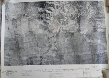
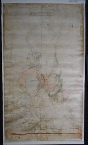
Photograph (item) - Set of 8 1945 B& W Photomaps, mounted on linen, most with geological annotations, as follows: Castlemaine A1, 817 A1, Zone 7, 1945; Bendigo A2 -Eaglehawk Aqueduct, Bullock Creek and Lockwood; Bendigo A4, 807 A4, Zone 7, 1945; Bendigo B1 - Golden Square, Kangaroo Flat, Splitters Creek, Strathfieldsaye Creek, Sheepwash Creek, Spring Gully Reservoir; Bendigo B3, 807 B3, Zone 7, 1945; Bendigo C3, 807 C3, Zone 7, 1945; Bendigo D3, 807 D3, Zone 7, 1945; Huntly C4 - Eaglehawk, Marong, Myers Flat, 1945
... Set of 8 1945 B& W Photomaps, mounted on linen, most with geological annotations, as follows: Castlemaine A1, 817 A1, Zone 7, 1945; Bendigo A2 -Eaglehawk Aqueduct, Bullock Creek and Lockwood; Bendigo A4, 807 A4, Zone 7, 1945; Bendigo B1 - Golden Square, Kangaroo Flat, Splitters Creek, Strathfieldsaye Creek, Sheepwash Creek, Spring Gully Reservoir; Bendigo B3, 807 B3, Zone 7, 1945; Bendigo C3, 807 C3, Zone 7, 1945; Bendigo D3, 807 D3, Zone 7, 1945; Huntly C4 - Eaglehawk, Marong, Myers Flat...Set of 8 1945 B& W Photomaps, mounted on linen, most with geological annotations, as follows: Castlemaine A1, 817 A1, Zone 7, 1945; Bendigo A2 -Eaglehawk Aqueduct, Bullock Creek and Lockwood; Bendigo A4, 807 A4, Zone 7, 1945; Bendigo B1 - Golden Square, Kangaroo Flat, Splitters Creek, Strathfieldsaye Creek, Sheepwash Creek, Spring Gully Reservoir; Bendigo B3, 807 B3, Zone 7, 1945; Bendigo C3, 807 C3, Zone 7, 1945; Bendigo D3, 807 D3, Zone 7, 1945; Huntly C4 - Eaglehawk, Marong, Myers Flat...Phtotomap Printed aerial photographs mounted on linen Set of 8 1945 B& W Photomaps, mounted on linen, most with geological annotations, as follows: Castlemaine A1, 817 A1, Zone 7, 1945; Bendigo A2 -Eaglehawk Aqueduct, Bullock Creek and Lockwood; Bendigo A4, 807 A4, Zone 7, 1945; Bendigo B1 - Golden Square, Kangaroo Flat, Splitters Creek, Strathfieldsaye Creek, Sheepwash Creek, Spring Gully Reservoir; Bendigo B3, 807 B3, Zone 7, 1945; Bendigo C3, 807 C3, Zone 7, 1945; Bendigo D3, 807 D3, Zone 7, 1945; Huntly C4 - Eaglehawk, Marong, Myers Flat Photograph Set of 8 1945 B& W Photomaps, mounted on linen, most with geological annotations, as follows: Castlemaine A1, 817 A1, Zone 7, 1945; Bendigo A2 -Eaglehawk Aqueduct, Bullock Creek and Lockwood; Bendigo A4, 807 A4, Zone 7, 1945; Bendigo B1 - Golden Square, Kangaroo Flat, Splitters Creek, Strathfieldsaye Creek, Sheepwash Creek, Spring Gully Reservoir; Bendigo B3, 807 B3, Zone 7, 1945; Bendigo C3, 807 C3, Zone 7, 1945; Bendigo D3, 807 D3, Zone 7, 1945; Huntly C4 - Eaglehawk, Marong, Myers Flat ...Phtotomap -
 Bendigo Historical Society Inc.
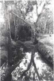
Photograph - BENDIGO ADVERTISER COLLECTION: BULLOCK CREEK (PROBABLY) AT LOCKWOOD SOUTH
... BENDIGO ADVERTISER COLLECTION: BULLOCK CREEK (PROBABLY) AT LOCKWOOD SOUTH...Probably Bullock Creek at Lockwood South. No writing on rear of image but in Lockwood South folder....Photograph BENDIGO ADVERTISER COLLECTION: BULLOCK CREEK (PROBABLY) AT LOCKWOOD SOUTH ...Probably Bullock Creek at Lockwood South. No writing on rear of image but in Lockwood South folder.region, small towns, lockwood south -
 Bendigo Historical Society Inc.
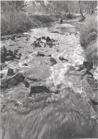
Photograph - BENDIGO ADVERTISER COLLECTION: BULLOCK CREEK LOCKWOOD SOUTH, 10/08/1993
... BENDIGO ADVERTISER COLLECTION: BULLOCK CREEK LOCKWOOD SOUTH...Lockwood South Bullock Creek in flood. On rear of image Lockwood Sth 10/8/93. ...PART OF THE SMALL TOWNS WITH BIG HEARTS SERIES Photograph BENDIGO ADVERTISER COLLECTION: BULLOCK CREEK LOCKWOOD SOUTH ...Lockwood South Bullock Creek in flood. On rear of image Lockwood Sth 10/8/93. PART OF THE SMALL TOWNS WITH BIG HEARTS SERIESregion, small towns, lockwood south -
 Bendigo Historical Society Inc.
Map - LOCKWOOD, November 25th 1855
... ... Bullock creek...Map: Garden Allotments within the Town Reserve of Lockwood on the Bullock Creek. Parish plan (number 273 in map cupboard 1)...History House 11 Mackenzie Street Bendigo goldfields MAP Bendigo parish plan Lockwood Garden Allotments Bullock creek Map: Garden Allotments within the Town Reserve of Lockwood on the Bullock Creek. ...Map: Garden Allotments within the Town Reserve of Lockwood on the Bullock Creek. Parish plan (number 273 in map cupboard 1)map, bendigo, parish plan, lockwood, garden allotments, bullock creek -
 Stawell Historical Society Inc
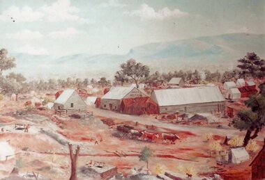
Photograph, Original Painting of The Reef Hotel Pleasant Creek with Bullock team in front from an original by Will Rees
... Original Painting of The Reef Hotel Pleasant Creek with Bullock team in front from an original by Will Rees...Original Painting of The Reefs Hotel Pleasant Creek with Bullock team in front from an original by Will Rees...Stawell Historical Society Inc 46 Longfield St Stawell grampians Original Painting of The Reefs Hotel Pleasant Creek with Bullock team in front from an original by Will Rees Stawell Original Painting of The Reef Hotel Pleasant Creek with Bullock team in front from an original by Will Rees Photograph ...Original Painting of The Reefs Hotel Pleasant Creek with Bullock team in front from an original by Will Reesstawell -
 Bendigo Historical Society Inc.
Document - EXTRACT FROM THE BENDIGO INDEPENDENT APRIL 16 1887: MYERS FAMILY/MYERS CREEK, 16th April, 1887
... ... Bullock Creek Hotel and Station...Reference to Mr Campbell, Bullock Creek Hotel and Station; Mr John Catto (Loddon homestead); Mouat Bros (Yarraberb Station) M'Intyre (squatter of Kangaroo Flat and Big Hill) ; Buzza's Paddock (Myers' Flat). ...History House 11 Mackenzie Street Bendigo goldfields PERSON Individual Myers Family Myers Flat Police Station Buzz's Paddock Bullock Creek Hotel and Station Port Phillip Myers Creek. ...Extract from the Bendigo Independent April 16 1887 re Myers Family/Myers Creek. Titled The local dawn of civilization - A Pre-auriferous pioneer. Settlement by William and Thomas Myers. Story of settlement of area told by first wife of William Myers (Mrs Hayward). Recollection of Mrs Hayward's re the naming of Bendigo ( ('bendy-go'). Reference to Mr Campbell, Bullock Creek Hotel and Station; Mr John Catto (Loddon homestead); Mouat Bros (Yarraberb Station) M'Intyre (squatter of Kangaroo Flat and Big Hill) ; Buzza's Paddock (Myers' Flat). Mention of Superintendent Gilbert and Dr Backhaus.Bendigo Independentperson, individual, myers family, myers flat police station, buzz's paddock, bullock creek hotel and station, port phillip, myers creek. -
Bendigo Historical Society Inc.
Map - CAMPBELL COLLECTION: BENDIGO AND DISTRICT MAPS
... Spring Creek centre of map and Bullock Creek to the right. Total area 4405 acres. ...Spring Creek centre of map and Bullock Creek to the right. Total area 4405 acres. ...Map. Lockwood, Parishes of Lockwood and Shelbourne, scale 20 chains to 1 inch. Spring Creek centre of map and Bullock Creek to the right. Total area 4405 acres. (number 358 in map cupboard 1)map, bendigo, allotments -
Bendigo Historical Society Inc.
Map - POMPAPIEL : COUNTY OF BENDIGO, 1-10-27
... Pompapiel, County of Bendigo, Calivil, Janiember East, Yarrayne, Salisbury, Yallook, Talambe, Judyong Creek, Bullock Creek, Pompapiel Creek, Edeyrn Estate. ...Pompapiel, County of Bendigo, Calivil, Janiember East, Yarrayne, Salisbury, Yallook, Talambe, Judyong Creek, Bullock Creek, Pompapiel Creek, Edeyrn Estate. ...Map. Pompapiel, County of Bendigo, Calivil, Janiember East, Yarrayne, Salisbury, Yallook, Talambe, Judyong Creek, Bullock Creek, Pompapiel Creek, Edeyrn Estate. Photo-Lithographed at the Department of Lands and Survey, Melbourne by W.J. Butson, 1-10-27, Price 1/-. (number 4 in map cupboard 1)W.J. Butson, Government Printermap, bendigo, pompapiel -
Bendigo Historical Society Inc.
Map - POMPAPIEL : COUNTY OF BENDIGO, 1-10-27
... Pompapiel, County of Bendigo, Calivil, Talambe, Yallook, Salisbury, Yarrayne, Janiember East, Waranga Mallee Channel, Judyong Creek.Pompapiel Creek, Bullock Creek, Blind Creek. Photo-Lithographed at the Department of Lands and Survey by W.J. ...Pompapiel, County of Bendigo, Calivil, Talambe, Yallook, Salisbury, Yarrayne, Janiember East, Waranga Mallee Channel, Judyong Creek.Pompapiel Creek, Bullock Creek, Blind Creek. Photo-Lithographed at the Department of Lands and Survey by W.J. ...Map. Pompapiel, County of Bendigo, Calivil, Talambe, Yallook, Salisbury, Yarrayne, Janiember East, Waranga Mallee Channel, Judyong Creek.Pompapiel Creek, Bullock Creek, Blind Creek. Photo-Lithographed at the Department of Lands and Survey by W.J. Butson, 1-10-27. Price 1/-. (number 84 in map cupboard 1)W.J. Butson.map, bendigo, pompapiel -
 Bendigo Historical Society Inc.
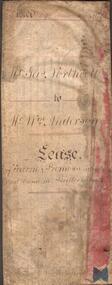
Document - INDENTURE DOCUMENT BETWEEN JAMES NORTHCOTT AND WILLIAM ANDERSON
... Indenture document, hand written in ink and ruled in red ink, between James Northcott, farmer and William Anderson ' of the same place' for 380 acres at Bullock Creek. Document is in poor condition and folded in four sections. ...History House 11 Mackenzie Street Bendigo goldfields RURAL INDUSTRY Farm property indenture Northcott and Anderson Indenture document, hand written in ink and ruled in red ink, between James Northcott, farmer and William Anderson ' of the same place' for 380 acres at Bullock Creek. Document is in poor condition and folded in four sections. ...Indenture document, hand written in ink and ruled in red ink, between James Northcott, farmer and William Anderson ' of the same place' for 380 acres at Bullock Creek. Document is in poor condition and folded in four sections. Document dated 1870.rural industry, farm property, indenture northcott and anderson -
Bendigo Historical Society Inc.
Map - SALISBURY : COUNTY OF BENDIGO, 1965
... Salisbury, County of Bendigo, Pompapiel, Yallook, Yarraberb, Yarrayne, Bullock Creek. Drawn and reproduced at the Department of Lands and Survey, Melbourne. ...Salisbury, County of Bendigo, Pompapiel, Yallook, Yarraberb, Yarrayne, Bullock Creek. Drawn and reproduced at the Department of Lands and Survey, Melbourne. ...Map. Salisbury, County of Bendigo, Pompapiel, Yallook, Yarraberb, Yarrayne, Bullock Creek. Drawn and reproduced at the Department of Lands and Survey, Melbourne. Price $1.00. 1965. By authority A.C. Brooks, Government Printer, Melbourne. (number 28 in map cupboard 1)A.C. Brooks,Government Printer, Melbourne.map, bendigo, salisbury -
Bendigo Historical Society Inc.
Map - SALISBURY : COUNTY OF BENDIGO, 1965
... Salisbury, County of Bendigo, Pompapiel, Yarrayne, Yarraberb, Yallook, Bullock Creek. By Authority: A.C. Brooks, Government Printer, Melbourne. ...Salisbury, County of Bendigo, Pompapiel, Yarrayne, Yarraberb, Yallook, Bullock Creek. By Authority: A.C. Brooks, Government Printer, Melbourne. ...Map. Salisbury, County of Bendigo, Pompapiel, Yarrayne, Yarraberb, Yallook, Bullock Creek. By Authority: A.C. Brooks, Government Printer, Melbourne. Drawn and reproduced at the Department of Lands and Survey, Melbourne.1965. Price $1.00. (number 6 in map cupboard 1)A.C. Brooks, Government Printermap, bendigo, salisbury -
Bendigo Historical Society Inc.
Map - CAMPBELL COLLECTION: BENDIGO & DISTRICT MAPS
... Scale 20 chains to 1 inch.Total area 4405 acres. Bullock Creek to the right, Spring Creek at Centre. ...Scale 20 chains to 1 inch.Total area 4405 acres. Bullock Creek to the right, Spring Creek at Centre. ...Map. Lockwood, Parishes of Lockwood and Shelbourne. Scale 20 chains to 1 inch.Total area 4405 acres. Bullock Creek to the right, Spring Creek at Centre. Newbridge is 11 miles N E, To Marong, Bendigo Lockwood roads are on the left. (number 375 in map cupboard 1)map, bendigo, agricultural lands -
Bendigo Historical Society Inc.
Map - BRIDGEWATER : COUNTY OF BENDIGO, 6-10-27
... Bridgewater, County of Bendigo, Inglewood, Salisbury, Derby, Leichardt, Yarraberb, Yarrayne, Bullock Creek, Loddon River, Sandhurst and Inglewood Railway. ...Bridgewater, County of Bendigo, Inglewood, Salisbury, Derby, Leichardt, Yarraberb, Yarrayne, Bullock Creek, Loddon River, Sandhurst and Inglewood Railway. ...Map. Bridgewater, County of Bendigo, Inglewood, Salisbury, Derby, Leichardt, Yarraberb, Yarrayne, Bullock Creek, Loddon River, Sandhurst and Inglewood Railway. Photo-Lithographed at the Department of Lands and Survey Melbourne by W.J. Butson, 6-10-27. Price 1/-. (number 53 in map cupboard 1)W.J. Butsonmap, bendigo, bridgewater -
Bendigo Historical Society Inc.
Map - POMPAPIEL : COUNTY OF BENDIGO, 1-10-27
... Pompapiel, County of Bendigo, Calivil, Talambe, Yallook, Salisbury, Yarrayne, Janiember East, Waranga Mallee Channel, Blind Creek, Judyong Creek, Bullock Creek. Photo-Lithographed at the Dept. of Lands and Survey Melbourne by W.J. ...Pompapiel, County of Bendigo, Calivil, Talambe, Yallook, Salisbury, Yarrayne, Janiember East, Waranga Mallee Channel, Blind Creek, Judyong Creek, Bullock Creek. Photo-Lithographed at the Dept. of Lands and Survey Melbourne by W.J. ...Map. Pompapiel, County of Bendigo, Calivil, Talambe, Yallook, Salisbury, Yarrayne, Janiember East, Waranga Mallee Channel, Blind Creek, Judyong Creek, Bullock Creek. Photo-Lithographed at the Dept. of Lands and Survey Melbourne by W.J. Butson 1-10-27. Price 1/-. (number 85 in map cupboard 1)W.J. Butsonmap, bendigo, pompapiel -
 Bendigo Historical Society Inc.
Newspaper - Naming of Bendigo
... They set up their head station at what is now Lockwood South on the Bullock Creek and was in the centre of the run. ...They set up their head station at what is now Lockwood South on the Bullock Creek and was in the centre of the run. ...Benjamin Heape and Richard Grice, with Charles Sherratt occupied a run of about 118,900 acres, called the Mount Alexander North Run. They set up their head station at what is now Lockwood South on the Bullock Creek and was in the centre of the run. ('Ravenswood Run 1839 - 2002', Rita Hull)One page photocopy of newspaper article 'Australian Town and Country Journal (Sydney 1870 - 1907) Saturday 21st September, 1878, page 17: article headline ' Origin of the name Bendigo', regarding a letter from Mr. Grice stating that Bendigo was named by Tom Myers, Heap and Grice's overseer. ravenswood run, heape and grice, sherratt, bendigo, origin of bendigo name -
Bendigo Historical Society Inc.
Map - MARONG : COUNTY OF BENDIGO, June 1953
... Map> Marong, County of Bendigo, Nerring, Sandhurst, Lockwood, Shelbourne, Woodstock, Leichardt, Bullock Creek, Fletcher Creek, Township of Marong, Bendigo Railway Line, Marong Railway Station, Crusoe Aqueduct. ...Map> Marong, County of Bendigo, Nerring, Sandhurst, Lockwood, Shelbourne, Woodstock, Leichardt, Bullock Creek, Fletcher Creek, Township of Marong, Bendigo Railway Line, Marong Railway Station, Crusoe Aqueduct. ...Map> Marong, County of Bendigo, Nerring, Sandhurst, Lockwood, Shelbourne, Woodstock, Leichardt, Bullock Creek, Fletcher Creek, Township of Marong, Bendigo Railway Line, Marong Railway Station, Crusoe Aqueduct. Drawn and reproduced at the Dept. of Lands and Survey, Melbourne, Victoria. June 1953. Price 2/-. By authority W.M. Houston, Government Printer. (number 74 in map cupboard 1)W.M. Houston, Government Printer.map, bendigo, marong -
Bendigo Historical Society Inc.
Map - MARONG : COUNTY OF BENDIGO, June 1953
... Marong, County of Bendigo, Nerring, Sandhurst, Lockwood, Shelbourne, Woodstock, Leichardt, Fletcher Creek, Bullock Creek, Township of Marong, Marong Railway Station, Bendigo Railway Line, Spring Creek, Crusoe Aqueduct. ...Marong, County of Bendigo, Nerring, Sandhurst, Lockwood, Shelbourne, Woodstock, Leichardt, Fletcher Creek, Bullock Creek, Township of Marong, Marong Railway Station, Bendigo Railway Line, Spring Creek, Crusoe Aqueduct. ...Map. Marong, County of Bendigo, Nerring, Sandhurst, Lockwood, Shelbourne, Woodstock, Leichardt, Fletcher Creek, Bullock Creek, Township of Marong, Marong Railway Station, Bendigo Railway Line, Spring Creek, Crusoe Aqueduct. By authority W.M. Houston, Government Printer. Drawn and reproduced at the Department of Lands and Survey, Melbourne, Victoria. June 1953. Price 2/-. (number 73 in map cupboard 1)W.M. Houston, Government Printermap, bendigo, marong -
 Stawell Historical Society Inc
Photograph, Photo of Mr Will Rees's painting of The Reef Hotel Pleasant Creek with a Bullock team in front
... Photo of Mr Will Rees's painting of The Reef Hotel Pleasant Creek with a Bullock team in front....Photo of Will Rees painting of The Reefs Hotel Pleasant Creek with Bullock team in front....Stawell Historical Society Inc 46 Longfield St Stawell grampians Photo of Will Rees painting of The Reefs Hotel Pleasant Creek with Bullock team in front. Stawell Photo of Mr Will Rees's painting of The Reef Hotel Pleasant Creek with a Bullock team in front. ...Photo of Will Rees painting of The Reefs Hotel Pleasant Creek with Bullock team in front.stawell -
 Bendigo Historical Society Inc.
Map - PLAN GENERAL SURVEY MALMSBURY PORCUPINE INN, FOREST CREEK TO GOLDEN POINT. ALEXANDRA RANGE 1853
... Colour Copy of Plan of the General Survey from the Town of Malmsbury to the Porcupine Inn, from the sources of Forest Creek to Golden Point, shewing (sic) the Alexandrian Range also Sawpit Gully Bendigo and Bullock Creeks. Handwritten note under the title a follows '' Forwarded to the Colonial Secretary with my letter No A 53/105 dated 30th March 1853 for transmission to the Geological Surveyor. ...Hoddle Colour Copy of Plan of the General Survey from the Town of Malmsbury to the Porcupine Inn, from the sources of Forest Creek to Golden Point, shewing (sic) the Alexandrian Range also Sawpit Gully Bendigo and Bullock Creeks. Handwritten note under the title a follows '' Forwarded to the Colonial Secretary with my letter No A 53/105 dated 30th March 1853 for transmission to the Geological Surveyor. ...Colour Copy of Plan of the General Survey from the Town of Malmsbury to the Porcupine Inn, from the sources of Forest Creek to Golden Point, shewing (sic) the Alexandrian Range also Sawpit Gully Bendigo and Bullock Creeks. Handwritten note under the title a follows '' Forwarded to the Colonial Secretary with my letter No A 53/105 dated 30th March 1853 for transmission to the Geological Surveyor. R Hoddle Surveyor General. ' Stamped by Department of Mines Victoria with record#123 in Top right Hand corner. Also contains a catalogue number 2053/M/2. Part of the Contents of a DVD entitled 'Mapping Great Change' - Archival Maps, produced to support an exhibition in the Post Office Gallery Bendigo. A description of the Map, its history and implications for both historical and future discussions is contained in an Essay 'Mapping Great Changes' : The landscape of central Victoria by Gerry Gill.R. Hoddlemap, bendigo, country lands -
Bendigo Historical Society Inc.
Newspaper - Bendigo Advertiser Collection: Small Town With Big Hearts Article on Marong, June 30 1993
... The document features a vivid description of Marong's picturesque landscape, including sunsets, Bullock Creek, gum trees, and local wildlife, capturing the town's rural charm. ...The document features a vivid description of Marong's picturesque landscape, including sunsets, Bullock Creek, gum trees, and local wildlife, capturing the town's rural charm. ...This document is a personal reflection on life in the small town of Marong. The reasons for living in Marong are described as deeply personal and sometimes hard to define, often tied to a sense of belonging and community.Tess Rule, a long-time resident, expresses genuine affection for Marong and its people, emphasizing the friendliness and strong social ties within the town. The document features a vivid description of Marong's picturesque landscape, including sunsets, Bullock Creek, gum trees, and local wildlife, capturing the town's rural charm. Tess values supporting local businesses and prefers to shop in Marong whenever possible, only traveling to nearby Bendigo for items unavailable locally. Marong is often overlooked by travelers who only see the main highway and intersection, missing the town's true character.Overall, the document conveys a deep appreciation for Marong's community spirit, natural beauty, and the importance of supporting local life. The creek is not permanent, but it is a significant natural feature, especially near the town's sporting grounds. The town is characterized by a strong sense of community and high levels of volunteer involvement, particularly in maintaining sporting grounds and organizing local events. Community members actively participate in fundraising and improvement projects, such as raising money for a new hall and restoring the historic shire hall. The Marong Hotel, built around 1917, is a central landmark and was once one of three hotels in town. The town has a history of gold mining and is located on the edge of the Golden Triangle.The old shire hall is being restored to its original 1908 condition, reflecting pride in local heritage. Marong supports a wide range of sports clubs (footy, tennis, swimming, shooting, riding, trotting, cricket, and more), which are central to community life. The hotel serves as a hub for both locals and travelers, with regulars including sports club members and truck drivers who stop for food. The population is around 580 and growing, as more people move from nearby urban areas. Ongoing development includes new housing and community facilities. The town is a notable stop for interstate truck drivers due to a sharp bend requiring them to slow down, leading to a gathering spot outside the hotel. The presence of palm trees throughout the town is a distinctive feature, with some believed to have spread from the hotel’s original palms.Small Towns With Big Hearts Maiden Gully. Series of photos and information about Marong. Pictures by Peter Hyett. Written by Wayne Gregson. This item contains the following documents newspaper articles and black and white photos: 8091.603a Part of Page 10, the Bendigo Advertiser Wednesday June 30 1993 8091.603b Part of Page 10, the Bendigo Advertiser Wednesday June 30 1993 8091.603c Church in Marong - Contact BHS for details 8091.603d Church in Marong - Contact BHS for details 8091.603e Holy Trinity Church in Marong - Contact BHS for details 8091.603f Former Shire of Marong Hall undergoing renovations - Contact BHS for details 8091.603g Calder Highway sign - Contact the BHS for details 8091.603h Picnic Table and Golf Course - Contact the BHS for details 8091.603i The Marong Hotel - Contact the BHS for details 8091.603j The Marong Hotel and Old Shire Hall from the railway crossing - Contact the BHS for details 8091.603k Rural City of Marong Chief Executive Officer Graeme Elvey inspects the $120,000 Shire of Marong Hall undergoing renovations - Contact BHS for details 8091.603l Rural City of Marong Chief Executive Officer Graeme Elvey inspects the $120,000 Shire of Marong Hall undergoing renovations - Contact BHS for details 8091.603m Truck entering Marong from the Calder Highway - Contact BHS for details 8091.603n The Post Mistress - Contact BHS for details 8091.603o Bar and patrons of the Marong Hotel - Contact BHS for detailsnewspaper, bendigo advertiser, marong -
 Stawell Historical Society Inc
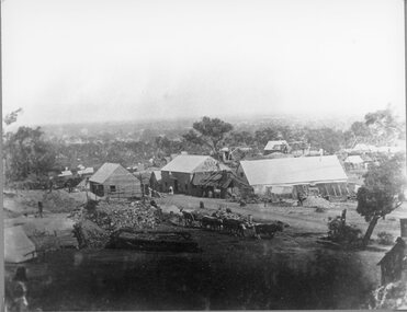
Photograph, First known photograph of The Reefs and Reef Hotel Pleasant Creek with a bullock team in front 1858 -1861
... First known photograph of The Reefs and Reef Hotel Pleasant Creek with a bullock team in front 1858 -1861...B/W Photo The Reefs Hotel and Assembly Hall Pleasant Creek with Bullock team in front. 1858 -1861 Three windlasses over mineshafts can be seen, two on the left and one in front of the assembly hall. ...Stawell Historical Society Inc 46 Longfield St Stawell grampians B/W Photo The Reefs Hotel and Assembly Hall Pleasant Creek with Bullock team in front. 1858 -1861 Three windlasses over mineshafts can be seen, two on the left and one in front of the assembly hall. ...B/W Photo The Reefs Hotel and Assembly Hall Pleasant Creek with Bullock team in front. 1858 -1861 Three windlasses over mineshafts can be seen, two on the left and one in front of the assembly hall. Some horse driven Whims can be seen in the background above the Assembly Hall. This hotel was built right among the mines in upper Main Street. The first licence was held by William Pond in 1858. Robert Young in 1859 and John Steele in 1861. It had a short life as only rates were paid in 1862.Earliest known photograph of the Reefs Pleasant Creek.Several buildings in mining area with trees in background, one building labelled The Reefs Hotel. Spoil heaps in foreground with other mining activities and with bullock team and cart. Man can be seen standing on slab hut roof at centre and woman in street. stawell, hotel -
 Bendigo Historical Society Inc.
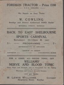
Document - BACK TO EAST SHELBOURNE SPORTS CARNIVAL, 8 October, 1927
... Next 8 pages contain information on the history of East Shelbourne beginning with; This district is situated about ten miles west of south-west of Bendigo on Back Creek or Spring Creek, which received its names from the early diggers of Bendigo who, through shortage of water, were compelled to puddle at Bullock Creek or further 'back,' hence Back Creek; and because of the number of springs it contained - Spring Creek. ...Next 8 pages contain information on the history of East Shelbourne beginning with; This district is situated about ten miles west of south-west of Bendigo on Back Creek or Spring Creek, which received its names from the early diggers of Bendigo who, through shortage of water, were compelled to puddle at Bullock Creek or further 'back,' hence Back Creek; and because of the number of springs it contained - Spring Creek. ...Back To East Shelbourne Sports Carnival, Saturday, October 8, 1927. Programme. Refreshments on grounds, dance at night. 1/- Casamento's Buses. Executive Committee: President; W Harris. Vice-President; M De Araugo. Messrs. E Wright, A D Holden, W Hamilton, J Bartels, J Hinck, and H Hinck. Hon. Sec.; H M Burke. Asst. Hon. Sec.; G H Marshall. Ladies; Mesdames J Bartels, H Burke, G H Marshall, E Pocock, R Vines, and E Wright. General Committee; In addition to the above, Messrs. E Pocock, J De Araugo, F J Roberts, and W Marshall, Mesdames W Harris, A Holden, J De Araugo, F J Roberts, and Miss Pocock. Officials Judges: Messrs. T D Cairns, J Craven, and Geo. Hogben. Handicappers: Mr P Davidson (Northern District Walker's Assn.) Starter: Mr W Harris, M De Araugo, J Hinck, H Hovenden, E Pocock, W Hamilton, F J Roberts, A D Holden. Timekeeper: Mr H Hinck. Patrons: Cr, J Bartels, Nuttall & Clarke, Mrs D Punton, R S V Cocking, J Murray, and A Wells. Next 8 pages contain information on the history of East Shelbourne beginning with; This district is situated about ten miles west of south-west of Bendigo on Back Creek or Spring Creek, which received its names from the early diggers of Bendigo who, through shortage of water, were compelled to puddle at Bullock Creek or further 'back,' hence Back Creek; and because of the number of springs it contained - Spring Creek. Among the first to settle, in 1860, were Messrs. John Jenkinson, J Kilgour, T Connelly, G Nichols, R Fox, (who married Mrs James Jenkinson), Kenny, J Roberts, J Genders, J Curry, G Nevinson, Bartram, J Geary, A Nicholl, H Spencer, W Saunders, Mrs Prichard, and J Stansfield. History of East Shelbourne continues . . . Events held were Boy's (State School) Bicycle Race, Stepping the Distance (Gents), Stepping the Distance (Ladies), Bowling at the Stump, Kicking Football Through Hoop, Sheaf Toss, Bucket Ball, Sheffield, Children's Relay Race, Men's Potato Race, Tilting Rings, on Bikes, Walking Contest 1 mile, Car Race through pegs, Slow Bicycle Race 50 yards, Handicap Bicycle Race 2 miles, Tilting Rings in Cars, High Jump, Ladies' and Gent's Cigarette Race, Weight Guessing. Prizes were awarded for first and second placing of these events.In 1923, a Sports Carnival was held in the precincts of what was then a water reserve, situated south of the State School. The area was reserved for watering purposes on 1st May, 1894; and on July 15th, 1912, a small portion was excised. By 1923 its usefulness for water storage had disappeared, and being ideal for recreation purposes, it was decided, at the final meeting of the above sorts carnival, to apply for the area appointed, Mr W Harris (chairman), Messrs. G H Marshall, J Roberts, D Gill, M Connolly, R Vines, E Pocock, and H M Burke (secretary). The matter terminated in a Land Board, presided over by Mr McPherson, being held in Bendigo. The application was granted, but was not gazetted, until Messrs. W Harris and F J Roberts, with Messrs. A E Cook, MLA and Hon. H Keck, MLC interviewed the Minister for Lands. Soon afterwards, at a public meeting, the following members were elected to constitute the first Board of management, Messrs. W Harris (chairman), G H Marshall, A D Holden, F J Roberts (tres.), M D'Araugo, E Wright, and H M Burke (sec.). Since then the arena has been cleared and levelled by residents, and labor and material to the value of 150 pounds have been put into the reserve. At least 2/3rds of the program contain ads from business in Bendigo. Fordson Tractor - W Cowling, W Lewis William's Chymist, Collier footwear, William Wallace Land and Clearing Sales, Bain & Daws Groceries, Farmers & Citizens Trustees Company Bendigo Limited, Northern Seed Supply Co., Marong Bakery, Bennetts' Arcade Store, Marong Hotel, Warren's Drapery & Clothing, Jas. Friswell Butcher, Webster's Wireless, Baker & Woods Tennis Supplies, Hartleys Wireless, Cycle Hartleys, Bendigo Book & Stationery Centre Frank J Every's, T R Jones Chemist, Wool Skins & Hides F Ferguson, Furniture Carpets Linoleums Morley Johnsons, Jewellery & Silverware Prescott & Dawe, Drapers Honan & O'Toole, Stilwell's of Bendigo, Gents' & Ladies' Tailoring Hatters & Mercers Messrs. Denton Bros., Groceries Ales Wines & Spirits W Jeffrey, Ashman's Tailors Hatters Mercers, Myer's, Farmers' Grocery D Whyte & Co., Drapers & Furniture Stores The Beehive, Butcher les. Friswell, Tobacconist & Hairdresser W J Lenten, Timber Merchants & Ironmongers Hume & Iser, Stock E M Vains & Co., Ladies' & Gents' Tailors Clifford & Fulton, Printers & Stationers Bolton Bros. Pty Ltd, Bendigo Leather Shop, Everything Musical Suttons, Andrew's Auction Rooms Butter Eggs Poultry etc, Meats A C Petherick's, Albert Bush's Produce Stores & Chaff Mills, T D Cairns & Co., Jeweller C J Kirby, Casamento's Garage & Ballarat Motor Bus Service, Webster Bros. Sporting House Cycle Builders Motor Cycle & Car Agents, British Motors Bendigo, Webb's Bacon Depot. 20 pages plus coverBoltons Print, Bendigoevent, social, east shelbourne sports carnival -
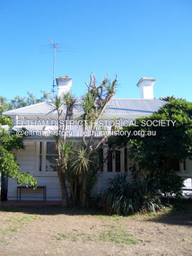
 Eltham District Historical Society Inc
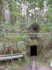
Photograph - Digital Photograph, Marguerite Marshall, One Tree Hill Mine, Smiths Gully, 8 June 2006
... Creek, Warrandyte. Then in 1854, George Boston and two other men discovered gold at Smiths Gully. Gold transformed the quiet districts, with a constant flow of families and vehicles on the dirt tracks en route to the Caledonia Diggings. Three thousand people worked the gullies in Market Square, including about 1000 Chinese miners. The square established its own police, mining warden, gold battery, school, shops and cemetery and grog flowed. Market Square flourished until the middle 1860s. Bullocks...Creek, Warrandyte. Then in 1854, George Boston and two other men discovered gold at Smiths Gully. Gold transformed the quiet districts, with a constant flow of families and vehicles on the dirt tracks en route to the Caledonia Diggings. Three thousand people worked the gullies in Market Square, including about 1000 Chinese miners. The square established its own police, mining warden, gold battery, school, shops and cemetery and grog flowed. Market Square flourished until the middle 1860s. Bullocks ...Gold was discovered on One Tree Hill in 1854. The site has been worked intermittently until fairly recent times. Published: Nillumbik Now and Then / Marguerite Marshall 2008; photographs Alan King with Marguerite Marshall.; p53 Though still a working mine, One Tree Hill Mine at Smiths Gully, now stands in a tranquil reserve surrounded by bush and native animals - in contrast to its heyday. In the mid 19th century, when the mine was part of the Caledonia Goldfields, hundreds of men in search of their fortune worked the alluvial gold in the Yarra River, its tributaries and the reefs that made up the goldfields. Miner Stan Bone, assisted by Wilfred Haywood, is the last of the independent gold miners in the area and still uses the quartz crushing battery as miners did when gold was first discovered in the area in 1851.1 Stan, who is the last of six generations of miners in his family, was aged 17 when he began mining on his father Alex’ mine, The Golden Crown in Yarrambat. These days, after blasting the gold-bearing rock in Mystery Reef, one of the four reefs at One Tree Hill, Stan transports it around five kilometres by tip truck to the Black Cameron Mine for crushing. There he uses water from the waterlogged mine, (which still contains gold), as the Happy Valley Creek at One Tree Hill is usually dry.2 The One Tree Hill Mine has been worked for close to a century since it opened around the late 1850s.3 The Swedish Reef was its most productive reef and one of the largest in the area. Around 1859, extractions included 204 ounces (5.8kg) of gold, won from 57 pounds (26kg) of stone.4 Then during World War Two, Stan’s uncle, Bill Wallace, and Alex Bone, closed the mine. In 1973, Stan, with his Uncle Bill, reopened the Black Cameron Mine and worked there until 1988. Stan resumed mining One Tree Hill in 1998. As late as the 1920s gold was picked up by chance! When crossing a gully on his way to vote at the St Andrews Primary School, Bill Joyce picked up some quartz containing gold. This site was to become the Black Cameron Mine. The Caledonia Diggings, named after Scotland’s ancient name by local Scots, began around Market Square (now Smiths Gully) and included Queenstown (St Andrews), Kingstown (Panton Hill) and Diamond Creek. There were also poorer bearing fields in Kangaroo Ground and Swipers Gully (now Research). * None of these compared in riches to the Ballarat and Bendigo fields5, but the Caledonia Diggings continued intermittently for close to 100 years. Gold was discovered in Victoria following a bid to stem the disappearance of much needed workmen to the New South Wales diggings. Several businessmen offered a reward of £200, for the discovery of gold within 200 miles (322 km) of Melbourne. Late in June 1851, gold was first discovered at Andersons Creek, Warrandyte. Then in 1854, George Boston and two other men discovered gold at Smiths Gully. Gold transformed the quiet districts, with a constant flow of families and vehicles on the dirt tracks en route to the Caledonia Diggings. Three thousand people worked the gullies in Market Square, including about 1000 Chinese miners. The square established its own police, mining warden, gold battery, school, shops and cemetery and grog flowed. Market Square flourished until the middle 1860s. Bullocks transported quartz from the Caledonia Goldfields to the crushing machinery at the Queenstown/St Andrews Battery, near Smiths Gully Cemetery. It was destroyed by bushfire in 1962. By the late 1850s, most early alluvial fields were in decline, but minor rushes continued until around 1900 and some until the early 1940s. Some miners did well, although most earned little from their hard labour in the harsh and primitive conditions.6 But according to historian, Mick Woiwod, the gold fields helped to democratise society, as individuals from all walks of life were forced to share experiences, and the ability to succeed, depended less on inherited wealth or social rank.This collection of almost 130 photos about places and people within the Shire of Nillumbik, an urban and rural municipality in Melbourne's north, contributes to an understanding of the history of the Shire. Published in 2008 immediately prior to the Black Saturday bushfires of February 7, 2009, it documents sites that were impacted, and in some cases destroyed by the fires. It includes photographs taken especially for the publication, creating a unique time capsule representing the Shire in the early 21st century. It remains the most recent comprehenesive publication devoted to the Shire's history connecting local residents to the past. nillumbik now and then (marshall-king) collection, gold mining, one tree hill mine, smiths gully -
 Eltham District Historical Society Inc
Photograph - Digital Photograph, Alan King, Allwood House, Hurstbridge, 16 April 2008
... Hurst proved equal to the tough conditions and he and his brother, Fred, cut a track with a bullock team from the property to Romsey, where Haley had selected some land. Hurst also put up a bridge across the creek near his house, after which Hurstbridge was named. ...Hurst proved equal to the tough conditions and he and his brother, Fred, cut a track with a bullock team from the property to Romsey, where Haley had selected some land. Hurst also put up a bridge across the creek near his house, after which Hurstbridge was named. ...Allwood - built in 1894 by Henry Hurst’s relatives, stands near the site of his house, which was demolisherd in the 1940s. Until 1924 Hurstbridge was known as Allwood. The building, one of the district's oldest is situated back from the corner of Arthurs Creek Road and Main Road. Covered under Heritage Overlay, Nillumbik Planning Scheme Published: Nillumbik Now and Then / Marguerite Marshall 2008; photographs Alan King with Marguerite Marshall.; p17 Hurst, who was a surveyor, came to Melbourne in 1852 by default, as on the way to Sydney he contracted typhoid and was off-loaded in Melbourne. Deciding to settle near Melbourne, he selected some land near the present Eltham railway station and was one of the first to grow crops there.2 But disaster struck again, when his shack was looted and burned, while he was carting goods for sale to nearby goldfields. It was then that Hurstbridge’s first settler, Cornelius Haley, asked Hurst to manage his 160 acres (65ha) grazing property and 9000 acres (3443ha) of leased land where the present Hurstbridge stands. Hurst proved equal to the tough conditions and he and his brother, Fred, cut a track with a bullock team from the property to Romsey, where Haley had selected some land. Hurst also put up a bridge across the creek near his house, after which Hurstbridge was named. He ran the property helped by two ticket-of-leave men and others, several of whom were sailors who had abandoned ship in search of gold, and were working there temporarily. In 1866, only 14 years after coming to Australia, Hurst met an early tragic death. One day a bushranger named Burke came to the house and demanded a horse. Hurst thought the bushranger might be an officer in search of runaway sailors3 and anyway, did not like the look of him, so he refused. A tussle followed and apparently Hurst shot first.4 He was shot and died five hours later from loss of blood. Later, troopers found Burke, who was subsequently hanged. The event is recorded in the Old Melbourne Gaol. The government offered the family £500 but the family refused it as ‘blood money’. Hurst’s father, Robert, even signed a petition against the bushranger’s death, claiming one life did not replace another. Hurst’s family continued to live in the district and saw a rise in their fortunes. They bought Haley’s cattle station and built the present Allwood House, using the original home as an orchard packing shed. The present Victorian style timber house had several outbuildings including a blacksmith’s shop. The property passed on to William Gray, an orchardist and nurseryman, who married Hurst’s grandniece, Frances. The business boomed from the early 1900s when it supplied most of the orchards in the area. Gray was Eltham Shire’s President for two terms and was asked to stand for parliament, but his wife’s illness and other family commitments prevented him from doing so. Then several calamities drove the family to bankruptcy. During World War One, Gray lost more than one million pounds on trees shipped overseas, which the Lloyd’s company had refused to insure. Other factors, including the Great Depression, ruined the family’s fortunes. The land was reduced from more than 640 acres (256ha) to 50 acres (20ha) and the older members married and left. After Mr Gray died, the house was leased, until his daughter Sheila Ferguson and her husband Gordon settled there in 1951, after buying it from other family members. However in 1975 the Shire designated the property as a passive recreation reserve. The Ferguson family sold most of the land, leaving the house on 0.6 hectares.This collection of almost 130 photos about places and people within the Shire of Nillumbik, an urban and rural municipality in Melbourne's north, contributes to an understanding of the history of the Shire. Published in 2008 immediately prior to the Black Saturday bushfires of February 7, 2009, it documents sites that were impacted, and in some cases destroyed by the fires. It includes photographs taken especially for the publication, creating a unique time capsule representing the Shire in the early 21st century. It remains the most recent comprehenesive publication devoted to the Shire's history connecting local residents to the past. nillumbik now and then (marshall-king) collection, hurstbridge, henry hurst, allwood house -
Glen Eira Historical Society
Document - Gisborne Street, 15, Elsternwick
... Gisborne Street Elsternwick Carre-Riddell John Riddell’s Creek Moore John McClenagham D Williams Evelyn Herwig August W Herwig L U Leeming L U Bullocks Hilary Landells Rosalind Jenkins Mary Ann Houses Document Gisborne Street, 15, Elsternwick ...A one page research report by the Brighton Historical Society, dated 19/04/1988 on 15 Gisborne Street, Elsternwick, previously 8 Gisborne Street. The report provides a brief history of the property and includes a list of residents from 1892 to 1974. The file also includes one page of handwritten, undated and unattributed working notes relating to 15 Gisborne Street, Elsternwick.gisborne street, elsternwick, carre-riddell john, riddell’s creek, moore john, mcclenagham d, williams evelyn, herwig august w, herwig l u, leeming l u, bullocks hilary, landells rosalind, jenkins mary ann, houses -
Glen Eira Historical Society
Document - Glen Orme Avenue, 2, McKinnon
... Creek... Murray Road... Baker Samuel... Baker F J... Morris J R... Dewhurst Edward Y... Jamrich B... Dendy Henry... Were J B... Bullock...Landells Rosalind Bick David Railway Park Glen Orme Avenue Glenorme Avenue McKinnon Pine Grove Pinegrove Elster Creek Murray Road Baker Samuel Baker F J Morris J R Dewhurst Edward Y Jamrich B Dendy Henry Were J B Bullock Hilary Document Glen Orme Avenue, 2, McKinnon ...A one page typed research note by Rosalind Landells of the Brighton Historical Society regarding 2 Glen Orme Avenue / Pinegrove, McKinnon, dated 10/07/1991. The note lists the previous owners of the property and gives a brief history of the land. The file also includes one page of handwritten, undated and unattributed working notes.landells rosalind, bick david, railway park, glen orme avenue, glenorme avenue, mckinnon, pine grove, pinegrove, elster creek, murray road, baker samuel, baker f j, morris j r, dewhurst edward y, jamrich b, dendy henry, were j b, bullock hilary -
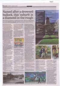 Greensborough Historical Society
Article - Newspaper Clipping, The Age, Named after a drowned bullock, this 'suburb' is a diamond in the rough, 31/08/2024
... Greensborough Historical Society 34A Glenauburn Road Lower Plenty Lower Plenty melbourne Article about the people and places relating to Diamond Creek, including its history and people of note. diamond creek diamond creek - places Article over 2 pages, text with with colour and black and white images Named after a drowned bullock, this 'suburb' is a diamond in the rough Article Newspaper Clipping The Age ...Article about the people and places relating to Diamond Creek, including its history and people of note.Article over 2 pages, text with with colour and black and white imagesdiamond creek, diamond creek - places -
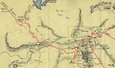 Halls Gap & Grampians Historical Society
Map - Coloured
... Creek Gorge in the late 1850s. Wakeham is credited for the clearing and levelling of the first bridle-path up the gorge. 1870s By the mid 1870s the track had been extended over Valley Gap to the Victoria Forest (the upper region of the Victoria Valley). McKeon's bullock...Creek Gorge in the late 1850s. Wakeham is credited for the clearing and levelling of the first bridle-path up the gorge. 1870s By the mid 1870s the track had been extended over Valley Gap to the Victoria Forest (the upper region of the Victoria Valley). McKeon's bullock ...Background on Bridle Path up Stony Creek Gorge Pre 1840 C. B. Hall, squatter on Mokepilly Run 1841-1842, first European to discover the Fyans Creek valley, the entrance of which became known as Hall's Gap. He later recorded that he followed a number of tracks which he assumed had been made by the Aboriginies and described one as "leading up a wild romantic glen and over on to the source of the Glenelg River". This could well have been the route taken up Stony Creek gorge by the first timber-cutters in this part of the Grampians to the saddle between the Wonderland and Mt. Difficult ranges known as Valley Gap 1850s/60s Timber cutters and shingle splitters were reported to be moving into the eastern side of the Grampians and by the mid 1860s there were a number of families connected to the supplying of timber to Pleasant Creek living in the "Hall's Gap ranges". John Wakeham, the first store owner in Pleasant Creek in 1854, established a timer-mill in upper Stony Creek Gorge in the late 1850s. Wakeham is credited for the clearing and levelling of the first bridle-path up the gorge. 1870s By the mid 1870s the track had been extended over Valley Gap to the Victoria Forest (the upper region of the Victoria Valley). McKeon's bullock team was known to have hauled red gum from the Valley to Stawell in the late 1870s and the 1880s. 1880s In 1887 an article in the Pleasant Creek news describes the Stony Creek Gorge track as "being a ledge alongside the mountain range, formed in the early days with the aid of earth and timber, along which the bullock teams used to travel to Horsham and plains of the Wimmera beyond." 1890s Gold was discovered in the catchment area of Stony Creek and by the end of the 1890s a new track was built from "near the junction of Fyan's and Stony Creeks, up the gorge to the diggings settlement. The mining Department had paid L300 for its construction and, when completed, the track was "three miles and 30 chains in length, the side cuttings at the narrowest part being 10 feet between" and "the watercourses which cross the track at various points" having been "filled up with rocks rolled down the sides of the hills, and consequently there can be no damage caused by bushfires which destroyed the former wooden bridges erected on the old track to Wakeham's saw-mill, the remains of which are still to be seen at the side of the diggings" The article goes on to further describe the track as one which "can with ease travel with a two horse conveyance either up or down" and that the workmen engaged in the construction of the track would be attending "a ball that night at McKeon's farm near the mouth of the gap to celebrate the successful completion of the undertaking". 1900s At what time the bridle path was extended beyond Valley Gap to the Wartook basin on the Mt. Difficult Range has not yet been determined. However, it is known that, by the turn of the century, people were travelling between Halls Gap and the caretakers' residence at Wartook Reservoir along what was now known as the "Bluff Road. Wartook's embankment had been constructed in 1887 and at that time there was already a track from Rosebrook Station homestead (near the present day Wartook Pottery) to the reservoir. Philip Rose owned both Rosebrook and Wartook Stations from the mid 1840s to the late 1850s and had regularly leased the Wartook basin to Cobb & Co. to rest horses there. 1920s Following the war of 1914-1918, tourism really took off in the Grampians, and Halls Gap rapidly grew. People would travel as far as they could on the many tracks then hike to the many lookouts being discovered by local tour guides. This led to the need for access across the range so that horse riders and the increasing number of vehicles could travel between Horsham and Halls Gap. To this end, the Bluff Road was improved and extended on 1929 and at its opening in March, 1930, by Lady Somers it was renamed the Mt. Victory Road.Map of Mt Victory Road and othersaccess routes, mt victory rd, bridle path, roads -
 Bendigo Historical Society Inc.
Document - Naming of Bendigo - James Mouat
... James claimed only a few days before his death in June 1893 that 'Bendigo was named after a bullock driver, Jack Langdon, to whom was given the name of 'Bendigo' because he was constantly talking about the pugilistic celebrity and also fancied he was a bit of a 'Bendigo' himself'. (Obituary 13 June, 1893) Charles Sherratt Jack Langdon James Mouat Bendigo Picanniny Creek ...James Mouat's obituary: https://trove.nla.gov.au/newspaper/article/174256697. James claimed only a few days before his death in June 1893 that 'Bendigo was named after a bullock driver, Jack Langdon, to whom was given the name of 'Bendigo' because he was constantly talking about the pugilistic celebrity and also fancied he was a bit of a 'Bendigo' himself'. (Obituary 13 June, 1893) Two foolscap typed pages recounting James Mouat's recollections of how Bendigo was named. Pages have been taken from a lined journal. On top right hand corner of pages, '252' and '250', respectively. Typed recount has black and red pen alterations. On top of page '252' is typed 'James Mouat'. Author un-named. charles sherratt, jack langdon, james mouat, bendigo, picanniny creek, ravenswood run, mount alexander north run