Showing 11 items matching " central land office"
-
 Glen Eira Historical Society
Letter - Hopetoun, Hopetoun Street, 2, Elsternwick
... ... Central Land Office...A copy of a one page typed letter, from C J and T Ham of the Central Land Office to Florence M Cordner, dated 29/04/1904, providing a valuation of her property located at the corner of Glen Huntly Road and Hopetoun Street, Elsternwick. ...Glen Eira Historical Society 965 Glen Huntly Rd Caulfield VIC 3162 melbourne A copy of a one page typed letter, from C J and T Ham of the Central Land Office to Florence M Cordner, dated 29/04/1904, providing a valuation of her property located at the corner of Glen Huntly Road and Hopetoun Street, Elsternwick. ...A copy of a one page typed letter, from C J and T Ham of the Central Land Office to Florence M Cordner, dated 29/04/1904, providing a valuation of her property located at the corner of Glen Huntly Road and Hopetoun Street, Elsternwick. The valuation provides a description of the land, house improvements and architectural features and outlines possibilities for land subdivision. Noted on the document in pencil is 'From collection of Brighton Historical Society'.cordner florence mrs, glen huntly road, glenhuntly road, elsternwick, hopetoun street, moynsha, melrose, campbell a l, towers, verandahs, brick, stables, ham c j, ham t, c j & t ham, central land office, mansions -
 Eltham District Historical Society Inc
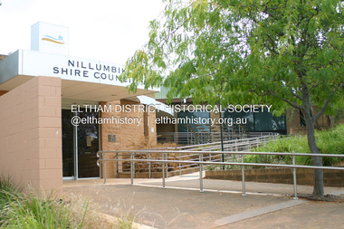
Photograph - Digital Photograph, Alan King, Nillumbik Shire Offices, Greensborough, 30 March 2008
... Although from 1858 to 1904, the council convened at the office in the home of Secretary Charles Wingrove, the board, and later the council, also met at other more central locations.3 The board moved from the Fountain of Friendship Hotel to the Eltham Courthouse, to the Kangaroo Ground schoolhouse. It then met at the Kangaroo Ground Hotel, which some considered put it in danger of interruptions by people ‘the worse for liquor’.4 In 1885 the council met at the hall on Mr J Donaldson’s land at Kangaroo Ground. ...Although from 1858 to 1904, the council convened at the office in the home of Secretary Charles Wingrove, the board, and later the council, also met at other more central locations.3 The board moved from the Fountain of Friendship Hotel to the Eltham Courthouse, to the Kangaroo Ground schoolhouse. It then met at the Kangaroo Ground Hotel, which some considered put it in danger of interruptions by people ‘the worse for liquor’.4 In 1885 the council met at the hall on Mr J Donaldson’s land at Kangaroo Ground. ...Nillumbik Shire Council transferred to the former Diamond Valley Shire Offices in Greensborough after municipal restructuing. The offices became the official Nillumbik Shire Council Offices on 16 October 1995. The former Shire of Diamond Valley Civic Centre or Shire Office building was officially opened on 26th February 1972. Archtiects were A.K. Lines, McFarlane & Marshall and it was built by L.U. Simon Pty Ltd, The Diamond Valley Shire had been created in 1964 from part of the City of Heidelberg. On December 15, 1994 the Shire of Nillumbik was established. Under the Council amalgamations imposed by the Kennett government, the Shire of Eltham, Shire of Diamond Valley and City of Heidelberg ceased to exist with the establishment of Nillumbik Shire Council and the City of Banyule.The new Nillumbik shire surrended the west riding from Eltham to Banyule but in place gained parts of the former Diamond Valley Shire which itself had been created in 1964 from parts of the City of Heidelberg. Three unelected and non-local Commissioners were put in place by the government bringing democracy into question by many members of the local community. The Commissioners determined to abandon the former Shire of Eltham offices located in Main Road, Eltham and in turn occupy the former Shire of Diamond Valley offices located at the boundary of the new shire with Banyule, in Civic Drive, Greensborough. In July 1996 the Commissioners sold the former Eltham Shire Offices and had them bulldozed leading to many years of communiity protest over the process and future development applications. The site has remained vacant ever since. Published: Nillumbik Now and Then / Marguerite Marshall 2008; photographs Alan King with Marguerite Marshall.; p43 It was the need for roads that led to this district’s first council. In 1853 a committee was formed to improve the rough roads, some in Kangaroo Ground being almost impassable in winter.1 The committee fundraised by voluntary levies and grants to improve in particular, the main road between Kangaroo Ground and the Plenty River. From this committee arose the Eltham District Road Board, in 1856, which was the precursor to the Eltham Shire Council. The Board’s first chairman was Kangaroo Ground farmer, John Barr. Secretary was the former committee’s secretary, Andrew Ross, Kangaroo Ground’s first school teacher, and founder of the district newspaper, The Evelyn Observer.2 Most of the board’s income came from a toll-house north of the Lower Plenty Bridge, which funded such projects as a road from Kangaroo Ground to the Caledonia Diggings. In 1871 the Shire of Eltham was proclaimed, with its boundaries the same as those of the Road Board, and Councillor A Donaldson of Kangaroo Ground was the first president. Eltham was at the southern tip of the shire, which extended north to Kinglake and east beyond Yarra Glen. In 1878, part of Kinglake was added to the shire, while the area east of Watts River, near Healesville was removed. In 1912, then again in 1958, the shire was further reduced. Yarra Glen, Steels Creek, Tarrawarra, parts of Healesville and Christmas Hills, were transferred to the Shire of Healesville. In 1972 a smaller area, at Kinglake, was transferred to the Shire of Yea, leaving 277 square kilometres in the Eltham Shire. Perhaps no other Victorian municipality has had so many meeting places. Although from 1858 to 1904, the council convened at the office in the home of Secretary Charles Wingrove, the board, and later the council, also met at other more central locations.3 The board moved from the Fountain of Friendship Hotel to the Eltham Courthouse, to the Kangaroo Ground schoolhouse. It then met at the Kangaroo Ground Hotel, which some considered put it in danger of interruptions by people ‘the worse for liquor’.4 In 1885 the council met at the hall on Mr J Donaldson’s land at Kangaroo Ground. After Wingrove’s retirement, the council rented space at the Kangaroo Ground General Store and Post Office. Then, in 1917, the council bought the former office of The Evelyn Observer, after its printing works transferred to Hurstbridge. In 1934, fire destroyed the shire office, which was temporarily relocated to the Kangaroo Ground home of Shire Secretary, Mr P J McMahon. In 1941, the shire office moved to a new building (which included a public hall) in Eltham, at the corner of Arthur Street and Main Road, where the Eltham Village Shopping Centre was eventually built. Growth required new offices, which opened in 1965, on the former Shillinglaw property in Main Road.5 In 1994, as part of municipal restructuring under the Jeff Kennett Liberal Government, most of the Eltham Shire formed part of the new Shire of Nillumbik. It joined with the north section of the Diamond Valley Shire and parts of the Healesville and Whittlesea municipalities. The Diamond Valley Shire had been created in 1964, from part of the City of Heidelberg. Turbulence followed Nillumbik Shire’s formation. Under the Commissioners the council transferred to the former Diamond Valley Shire offices in Greensborough, and the Eltham council offices were demolished. In March 1997 the first five-member Nillumbik Council was elected. But, in October 1998, the government suspended the council and appointed an administrator . Early in 1999, shire residents voted to increase councillors to nine: comprising five ward councillors and four shire-wide councillors. Elections were held in March 1999. Then, before the March 2002 elections, nine new wards were created.6 In 2008 these were reduced to seven. Today [2008] the council governs a varied population of more than 60,000 people living in townships and on bush properties in the green wedge.This collection of almost 130 photos about places and people within the Shire of Nillumbik, an urban and rural municipality in Melbourne's north, contributes to an understanding of the history of the Shire. Published in 2008 immediately prior to the Black Saturday bushfires of February 7, 2009, it documents sites that were impacted, and in some cases destroyed by the fires. It includes photographs taken especially for the publication, creating a unique time capsule representing the Shire in the early 21st century. It remains the most recent comprehenesive publication devoted to the Shire's history connecting local residents to the past. nillumbik now and then (marshall-king) collection, greensborough, nillumbik shire council offices, civic drive -
 Bendigo Historical Society Inc.
Document - PRESENTATION TO BHS 7TH JULY 2000: ''CAMP RESERVE'', 7th July 2000
... land which cradles a great deal of the history of Bendigo''. References to Commissioner Gilbert; Bank of Victoria; Bendigo Bank; powder magazine; post office; Survey Office; Court of Petty Sessions; Police Barracks; Supreme Court; Gaol; Temperance Society; Robert Strickland residence; tenements on Reserve; Mac's Track; Orderly Room; Cascades; Corporate High School; Temperance Fire Brigade; Masonic Hall; Central School Camp Hill; Fernery; ''The Willows''; Conservatory; Parade Ground; Sandhurst Club; Police Station; Grandstand in Upper Reserve; High School; Soldiers Memorial Insitutute; Lookout (poppet head - Garden Gully United); Advance Bendigo and North League crèche; Sound Shell; Olympic Swimming Pool. ...land which cradles a great deal of the history of Bendigo''. References to Commissioner Gilbert; Bank of Victoria; Bendigo Bank; powder magazine; post office; Survey Office; Court of Petty Sessions; Police Barracks; Supreme Court; Gaol; Temperance Society; Robert Strickland residence; tenements on Reserve; Mac's Track; Orderly Room; Cascades; Corporate High School; Temperance Fire Brigade; Masonic Hall; Central School Camp Hill; Fernery; ''The Willows''; Conservatory; Parade Ground; Sandhurst Club; Police Station; Grandstand in Upper Reserve; High School; Soldiers Memorial Insitutute; Lookout (poppet head - Garden Gully United); Advance Bendigo and North League crèche; Sound Shell; Olympic Swimming Pool. ...Presentation by James Lerk to BHS 7th July 2000: ''Camp Reserve -Rosalind Park, used and abused''. First line: ''This short paper has no pretension in giving a complete synopsis regarding a slice of land which cradles a great deal of the history of Bendigo''. References to Commissioner Gilbert; Bank of Victoria; Bendigo Bank; powder magazine; post office; Survey Office; Court of Petty Sessions; Police Barracks; Supreme Court; Gaol; Temperance Society; Robert Strickland residence; tenements on Reserve; Mac's Track; Orderly Room; Cascades; Corporate High School; Temperance Fire Brigade; Masonic Hall; Central School Camp Hill; Fernery; ''The Willows''; Conservatory; Parade Ground; Sandhurst Club; Police Station; Grandstand in Upper Reserve; High School; Soldiers Memorial Insitutute; Lookout (poppet head - Garden Gully United); Advance Bendigo and North League crèche; Sound Shell; Olympic Swimming Pool. Two printed copies.James Lerk.bendigo, streetscape, camp reserve, rosalind park, bendigo creek -
 Bendigo Historical Society Inc.
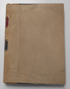
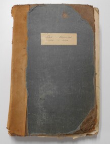
Document - LANDS OFFICE: APPLICATION REGISTER, SECTION 29 GRAZING AREAS LAND ACT 1898
... land board schedule. RH page: classification, lease, references and remarks. Details areas in central and northern Victoria. Dated from 22.12.1899 - 10.3.1906. Document LANDS OFFICE ...Document: hard cover indexed journal. On spine: red inset with 'Application Register' printed on gold, black inset with Section 29 Grazing Areas Land Act 1898' 'C' written in black ink. '35' and 1 - 1000' written above red inset. Journal has a loose slipcover of buff coloured linen-like material with cut-outs to allow information on spine to be viewed. Lh page: number of applications, date of registry, date of application, surname, Christian name and address, parish, allotment, section, area, local land board schedule. RH page: classification, lease, references and remarks. Details areas in central and northern Victoria. Dated from 22.12.1899 - 10.3.1906.land sales, victoria, lands office, bendigo, application register, applications for grazing land -
 Bendigo Historical Society Inc.
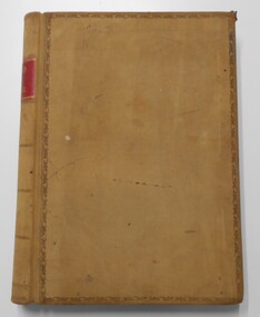
Document - LANDS OFFICE: CERTIFIED PLAN REGISTER
... Office Bendigo plans surveyed Victoria northern Victoria Document: hard cover journal. Buff cover with embossed edges. Spine has red insert with 'Certified Plan Register' printed in gold. 250 pages, with index in front of register. LH page: number, date of receipt, name, parish, tracing book, plan, decision of Board of land and works, gazette page, name of surveyors, date of survey, sent to, date. RH page: précis of minute. Dated 1878 - 1893, includes areas in central ...Document: hard cover journal. Buff cover with embossed edges. Spine has red insert with 'Certified Plan Register' printed in gold. 250 pages, with index in front of register. LH page: number, date of receipt, name, parish, tracing book, plan, decision of Board of land and works, gazette page, name of surveyors, date of survey, sent to, date. RH page: précis of minute. Dated 1878 - 1893, includes areas in central and northern Victoria.plan register, lands office, bendigo, plans, surveyed, victoria, northern victoria -
 Bendigo Historical Society Inc.
Document - LANDS OFFICE: SALE OF CROWN LANDS
... land sales Bendigo central and northern Victoria Hard cover journal, green cover with buff spine and edges. Sticker on the front: Sale register 1934-1954. On the spine in red the number 16 and in black Land Sales 10-01-1934 to 31-12-1954. Pages entered with details of sales by public auction of crown lands. LH page: lot, county, town or parish, allotment, section, area, survey fee paid, upset price per lot, sold for per lot. RH page: value of improvements if any, name of purchaser, address, purchase money paid, grant fees and assurance paid. Document LANDS OFFICE ...Hard cover journal, green cover with buff spine and edges. Sticker on the front: Sale register 1934-1954. On the spine in red the number 16 and in black Land Sales 10-01-1934 to 31-12-1954. Pages entered with details of sales by public auction of crown lands. LH page: lot, county, town or parish, allotment, section, area, survey fee paid, upset price per lot, sold for per lot. RH page: value of improvements if any, name of purchaser, address, purchase money paid, grant fees and assurance paid.land sales, victoria, crown land sales, bendigo, central and northern victoria -
 Ringwood and District Historical Society
Photograph, Maroondah Highway Central, Ringwood. Coffee Palace- 1923
... Office (our second), including Frank.V. Parker Estate Agent, Ellis & Co House & Land Agents, and entrance to Coffee Palace. Note telephone wires running along shop fronts. Black and white photograph (2 copies) Maroondah Highway Central ...Black and white photograph (2 copies)Image shows shops opposite station entrance just to right of old Post Office (our second), including Frank.V. Parker Estate Agent, Ellis & Co House & Land Agents, and entrance to Coffee Palace. Note telephone wires running along shop fronts. -
 University of Melbourne, Burnley Campus Archives
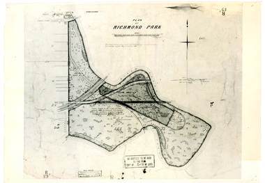
Plan, Plan of Richmond Park, 1886-1948
... Original plan dated 31 August 1872, note of Crown Grant to the Board of Land & Works and Richmond City Council 1886; showing land, "Permanently Preserved for the Gardens". Stamp, "Department of Lands and Survey Photographed at the Central Plan Office 1/1 Plate 7.12.48" (2) Also 2 photocopies, 1 reduced - possibly used in a publication...Original plan dated 31 August 1872, note of Crown Grant to the Board of Land & Works and Richmond City Council 1886; showing land, "Permanently Preserved for the Gardens". Stamp, "Department of Lands and Survey Photographed at the Central Plan Office 1/1 Plate 7.12.48" (2) Also 2 photocopies, 1 reduced - possibly used in a publication Plan of Richmond Park Plan ...(1) Black and white photographed copy of an original coloured plan. Plan of Richmond Park with Horticultural Society Gardens marked in. Includes additional land which became the Field Station. Original plan dated 31 August 1872, note of Crown Grant to the Board of Land & Works and Richmond City Council 1886; showing land, "Permanently Preserved for the Gardens". Stamp, "Department of Lands and Survey Photographed at the Central Plan Office 1/1 Plate 7.12.48" (2) Also 2 photocopies, 1 reduced - possibly used in a publication1 photocopy has "Figure 1. Plan of Burnley Gardens circa 1863 [sic]gardens, richmond, horticultural society of victoria, richmond park, a.l. martin -
 Ballarat Heritage Services
Photograph - Digital photographs, L.J. Gervasoni, Kew War Memorial and Cenotaph, c2017
... centrally-located site and allows a clear view of all faces of the memorial. It honours 917 local residents who served in World War One. Kew Municipal Council appointed a sub-committee in June 1919 to consider a suitable war memorial to commemorate soldiers from the district. In August 1920 the land in front of the Post Office...Office goldfields Kew War Memorial is a fine example of a classical style war memorial design. Built in granite and marble as a circular temple supported on ionic columns, its design takes advantage of the centrally-located site and allows a clear view of all faces of the memorial. It honours 917 local residents who served in World War One. Kew Municipal Council appointed a sub-committee in June 1919 to consider a suitable war memorial to commemorate soldiers from the district. In August 1920 the land ...Kew War Memorial is a fine example of a classical style war memorial design. Built in granite and marble as a circular temple supported on ionic columns, its design takes advantage of the centrally-located site and allows a clear view of all faces of the memorial. It honours 917 local residents who served in World War One. Kew Municipal Council appointed a sub-committee in June 1919 to consider a suitable war memorial to commemorate soldiers from the district. In August 1920 the land in front of the Post Office was transferred to the Council for the purpose. A competition for the design of the Memorial offered prizes of offered were £50, £15 and £10. The estimated cost was not to be more than £3500 F. Bruce Kemp won first prize, but Council later rejected the design constructing the Memorial to the original design of former Kew Council Mayor and notable Melbourne architect Harry W. Tompkins. The War Memorial was unveiled by His Excellency the Governor of Victoria, Lord Stradbroke on 30 August 1925 in front of 5,000 people. Digital images of the Kew War Memorial and the former Kew Post Office at Kew Junction at the intersection of High Street and Cotham Road.kew, war memorial, cotham road, high street, commemoration, kew junction, kew war memorial, kew post office, harry w. tomkins, cenotaph -
Ballarat Heritage Services
Photograph - Photograph - Colour, Hepburn Springs Reserv, 2025, 12/12/2020
... Office goldfields The Hepburn Mineral Springs Reserve is approximately 30 hectares of public land adjacent to Hepburn Springs township that includes the Hepburn Mineral Springs bathhouse. The reserve, which contains a series of mineral springs that have been in continuous public use for drinking and bathing since the mid-19th century, are the best known of the large concentration of more than 100 mineral springs in Victoria's Central Highlands first systematically inventoried by the Geological Survey of Victoria in 1910 under Director of E.J. ...The Hepburn Mineral Springs Reserve is approximately 30 hectares of public land adjacent to Hepburn Springs township that includes the Hepburn Mineral Springs bathhouse. The reserve, which contains a series of mineral springs that have been in continuous public use for drinking and bathing since the mid-19th century, are the best known of the large concentration of more than 100 mineral springs in Victoria's Central Highlands first systematically inventoried by the Geological Survey of Victoria in 1910 under Director of E.J. Dunn (1904 - 1912). A reserve of 0.5 hectares was first created on the site in 1868 to protect the springs from surrounding gold mining activities. The extent of the reserve was increased to its present size in the early 20th century as a result of local pressure for protection of the mineral springs local pressure and on the recommendation of Dunn that a network of Mineral Springs Reserves of standard size be established throughout Victoria.Colour photograph of Hepburn Springs Reserve and the encroaching weeds (broom, vinca, blackberry. .hepburn springs, locarno, mineral water, hepburn springs reserve, locarno spring, edna walling, hepburn springs pavilion -
 The Beechworth Burke Museum Research Collection
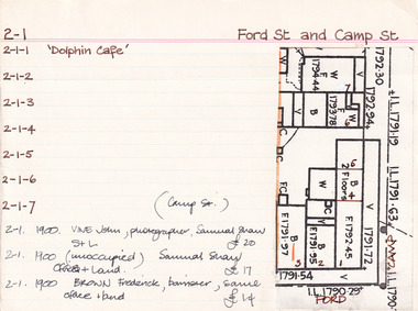
Card (Series) - Index Card, George Tibbits, Cnr Ford and Camp Streets, Beechworth, 1976
... land + prem as in 1861 - (oldest surviving building in Ford Street) 1900 - Vandenberg, Henry J. Tailor, same S+L £45 1900 - Falck C.F. watchmaker, S. Shaw S+L £30 1900 - Thomson, James Hotelkeeper, Forrest, B.C. Central Hotel + land £125 1900 - Vine, John, Photographer, Samuel Shaw, S+L £20 1900 - (unoccupied) Samuel Shaw, offices + land £17 1900 - Brown, Frederick, barrister, same, office + land £14 1906 - see entries under 2-2 - last two should perhaps be here. 1906 - Snowball, Joseph R. ...land + prem as in 1861 - (oldest surviving building in Ford Street) 1900 - Vandenberg, Henry J. Tailor, same S+L £45 1900 - Falck C.F. watchmaker, S. Shaw S+L £30 1900 - Thomson, James Hotelkeeper, Forrest, B.C. Central Hotel + land £125 1900 - Vine, John, Photographer, Samuel Shaw, S+L £20 1900 - (unoccupied) Samuel Shaw, offices + land £17 1900 - Brown, Frederick, barrister, same, office + land £14 1906 - see entries under 2-2 - last two should perhaps be here. 1906 - Snowball, Joseph R. ...George Tibbits, University of Melbourne. Faculty of Architecture, Building and Town & Regional PlanningIndex system that support the research for Beechworth : historical reconstruction / [by] George Tibbits ... [et al]Arranged by street names of BeechworthEach index card includes: street name and number of property, image of property, allotment and section number, property owners and dates of ownership, description of the property according to rate records, property floor plan with dimensions.beechworth, george tibbitsbeechworth, george tibbits