Showing 3 items matching " collmann and tacchi shaft"
-
 Bendigo Historical Society Inc.
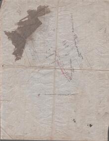
Map - MINING REPORTS - MAP OF COLLMANN AND TACCHI SHAFT
... MINING REPORTS - MAP OF COLLMANN AND TACCHI SHAFT...... Collmann and Tacchi Shaft...Hand drawn map showing the Collmann and Tacchi Shaft with No 17 Crosscut with the distances in feet and inches and the compass bearing of each leg. ...Map MINING REPORTS - MAP OF COLLMANN AND TACCHI SHAFT ...Collman and Tacchi shaft drawn on map corner of Dowding Street and Mt. Korong Road, California Gully, Bendigo. Mt Korong Road later became Eaglehawk Road. Hand drawn map showing the Collmann and Tacchi Shaft with No 17 Crosscut with the distances in feet and inches and the compass bearing of each leg. It is beside Mt Korong Road, near Dowding Street. Some boundary lines are drawn. Also on the map is Lansell's C and T across the road.map, bendigo, goldfields, mining reports, map of collmann and tachi shaft, collmann and tacchi shaft, lansell's c and t -
 Bendigo Historical Society Inc.
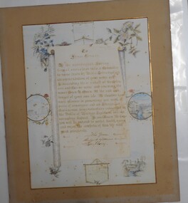
Award - ILLUMINATED ADDRESS: JAMES TONKIN, 1895
... Owen from suffocation in foul air at the Collmann and Tacchi Company’s No. 3 shaft in California Gully, Bendigo. ...Illuminated Address presented to James Tonkin recognising bravery, when he descended into a mine three times to rescue Owen R Owen who had fallen down a mine shaft at the Collmann and Tacchi Mine in 1895. The address reads: "James Tonkin" We, the undersigned, having formed ourselves into a committee to raise funds by public subscription in commendation of your noble art. ...Owen from suffocation in foul air at the Collmann and Tacchi Company’s No. 3 shaft in California Gully, Bendigo. ...The Illuminated Address was presented to James Tonkin on March 4, 1895, honouring his extraordinary bravery in rescuing miner Owen R. Owen from suffocation in foul air at the Collmann and Tacchi Company’s No. 3 shaft in California Gully, Bendigo. Mayor John Green, J.P., of Eaglehawk presented the address and a Mining Department bravery certificate at the Mechanics' Institute in California Gully. The document was created by local resident Mr. RogersIlluminated Address presented to James Tonkin recognising bravery, when he descended into a mine three times to rescue Owen R Owen who had fallen down a mine shaft at the Collmann and Tacchi Mine in 1895. The address reads: "James Tonkin" We, the undersigned, having formed ourselves into a committee to raise funds by public subscription in commendation of your noble art. In descending the No 3 shaft at the Collman and Tacchi mine and rescuing the miner Owen R Owen the risk and danger of your own life. We therefore have much pleasure in presenting you with a purse of sovereigns and an illuminated testimonial being voluntary subscribed in the public of Bendigo, Eaglehawk and the surrounding district. In conclusion we hope that you will be restored to perfect health again and enjoy the comforts of this life with great prosperity. Signed for the committee by John Green (Chairperson, Mayor of Eaglehawk), Richard Williams (Treasurer), Thomas Harry (Secretary). March 4th 1895illuminated address, james tonkin, miner -
 Bendigo Historical Society Inc.
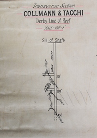
Map - Collmann and Tacchi, Unknown
... Printed in black text on top of plan: 'Transverse section, Collmann & Tacchi, Derby line of reef'. Plan shows shaft, sill of shaft, and geological features. ...Collman and Tacchi Gold Mine was located near the intersection of Eaglehawk Road and Rule Street, Long Gully. gold mining gold Bendigo Collman and Tacchi transverse section Printed in black text on top of plan: 'Transverse section, Collmann & Tacchi, Derby line of reef'. Plan shows shaft, sill of shaft, and geological features. ...Collman and Tacchi Gold Mine was located near the intersection of Eaglehawk Road and Rule Street, Long Gully. Printed in black text on top of plan: 'Transverse section, Collmann & Tacchi, Derby line of reef'. Plan shows shaft, sill of shaft, and geological features. Scale 100' = 1". Plan forms part of the Margaret Roberts Collection.gold mining, gold, bendigo, collman and tacchi, transverse section