Showing 6 items matching " counties of gladstone and talbot."
-
 Bendigo Historical Society Inc.
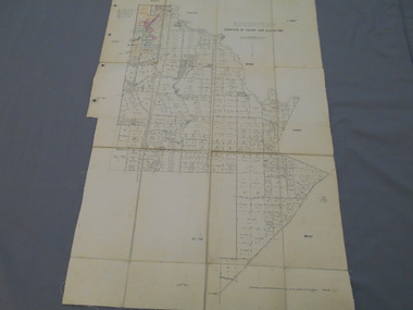
Map - JACK FLYNN COLLECTION: EDDINGTON, 1.12.1925
... ... Counties of Talbot... Gladstone...Map: Parish of Eddington, Counties of Gladstone and Talbot. Parish plan....History House 11 Mackenzie Street Bendigo goldfields MAP Talbot parish plan Eddington Counties of Talbot Gladstone Dept of Lands and Survey Melbourne by W.J. ...Map: Parish of Eddington, Counties of Gladstone and Talbot. Parish plan.Dept of Lands and Survey Melbourne by W.J. Butson 1.12.25map, talbot, parish plan, eddington, counties of talbot, gladstone -
 Bendigo Historical Society Inc.
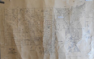
Map - JACK FLYNN COLLECTION: BET BET, 18/08/1931
... ... Counties of Gladstone and Talbot....Map: Parish of Bet Bet, Counties of Gladstone and Talbot . Parish plan....History House 11 Mackenzie Street Bendigo goldfields MAP Gladstone parish plan Bet Bet Counties of Gladstone and Talbot. By Authority H.J. ...Map: Parish of Bet Bet, Counties of Gladstone and Talbot . Parish plan.By Authority H.J. Green Govt, Printer. Photo Lithographed at the Department of Lands and Survey, Melbourne. 18.8.31map, gladstone, parish plan, bet bet, counties of gladstone and talbot. -
 Bendigo Historical Society Inc.
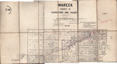
Map - JACK FLYNN COLLECTION: WAREEK, Examined 1918
... Parish of Wareek, Counties of Gladstone and Talbot. Parish plan. Looks like half of the sheet is missing....Parish of Wareek, Counties of Gladstone and Talbot. Parish plan. Looks like half of the sheet is missing. ...Map: L.1053. Parish of Wareek, Counties of Gladstone and Talbot. Parish plan. Looks like half of the sheet is missing.Second Issue. Examined by S.F. Green. July 1918. William J. Swan, Draughtsman, August 1884. Photo-Lithographic Fac-Simile, W 36.map, gladstone, parish plan, wareek -
 City of Greater Bendigo - Civic Collection
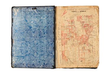
Administrative record - Land Sales, A. J. Mullet Government Printer, 1927
... Covers the Counties of Bendigo, Rodney, Gladstone and Talbot and Parishes of Kerang, Salisbury, Mandurang and Tarnagulla. ...Covers the Counties of Bendigo, Rodney, Gladstone and Talbot and Parishes of Kerang, Salisbury, Mandurang and Tarnagulla. ...This type of album was created by agents auctioning and selling land.Large portfolio style album with black cloth cover bound with three large metal pins. Blue marbled pastedown endpapers. Seventy nine pages, seventy five with Department of Lands and Survey maps attached. No index page. Maps have handwritten notes and markings throughout in pencil and pen. Covers the Counties of Bendigo, Rodney, Gladstone and Talbot and Parishes of Kerang, Salisbury, Mandurang and Tarnagulla. Includes a hand written note on William Wallace & Co letterhead. city of bendigo commerce -
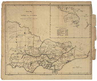 Federation University Historical Collection
Map, Robert Brough Smyth, Sketch Map of the Colony of Victoria, c1871, c1872
... Barker Library (top floor) Mount Helen goldfields victoria victorian counties robert brough-smyth telegraph population bourke rodney dalhousie evelyn mornington buln-buln tanjil dargo delatite moira bogong bendigo gunbower grant talbot hampden heytesbury polwarth ripon kara-kara gladstone grenville croajingolong tambo benambra This map includes the population of each County in Victoria according to the 1871 Census, as well as the population of each Australian colony and New Zealand. ...This map includes the population of each County in Victoria according to the 1871 Census, as well as the population of each Australian colony and New Zealand. Telegraph Route is given in a detail at the top right. victoria, victorian counties, robert brough-smyth, telegraph, population, bourke, rodney, dalhousie, evelyn, mornington, buln-buln, tanjil, dargo, delatite, moira, bogong, bendigo, gunbower, grant, talbot, hampden, heytesbury, polwarth, ripon, kara-kara, gladstone, grenville, croajingolong, tambo, benambra -
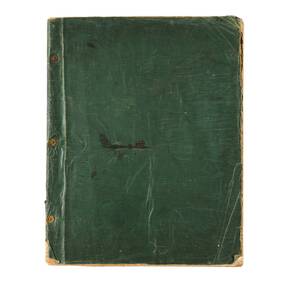 City of Greater Bendigo - Civic Collection
Administrative record - Land Sales, Department of Lands and Survey et al, 1929
... Covers the Counties of Bendigo, Rodney, Talbot, Gunbower, Gladstone, Tatchera and Karkarooc, Shires of East Loddon and Huntly and Swan Hill District. ...Covers the Counties of Bendigo, Rodney, Talbot, Gunbower, Gladstone, Tatchera and Karkarooc, Shires of East Loddon and Huntly and Swan Hill District. ...This type of album was created by agents auctioning and selling land.Large portfolio style album with green cloth cover bound with three large metal pins. One hundred and then pages with thirty three Department of Lands and Survey maps pasted in. Index page. Maps have handwritten notes and markings throughout in pencil and pen. Covers the Counties of Bendigo, Rodney, Talbot, Gunbower, Gladstone, Tatchera and Karkarooc, Shires of East Loddon and Huntly and Swan Hill District.