Showing 39 items matching " county of gladstone"
-
 Bendigo Historical Society Inc.
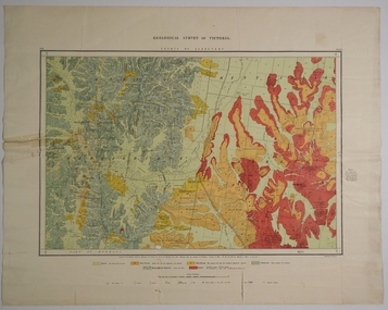
Map - COUNTY OF GLADSTONE, November 1910
... COUNTY OF GLADSTONE......County of Gladstone...Map: County of Gladstone, Geological survey of Victoria. ...Geological map Map COUNTY OF GLADSTONE ...Map: County of Gladstone, Geological survey of Victoria. Geological mapmap, gladstone, geological, county of gladstone, geological map -
 Federation University Historical Collection
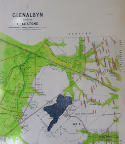
Map, Glenalbyn, County of Gladstone
... Glenalbyn, County of Gladstone......county of gladstone...Glenalbyn, County of Gladstone Map ...Copy of a geological map of Glenalbyn. Some areas have been colours green. Creeks have been coloured blue, roads and reefs have been coloured orange.glenalbyn, county of gladstone, tarnagulla, inglewood, kingower, kurting, old inglewood deep lead, salisbury west -
 Bendigo Historical Society Inc.
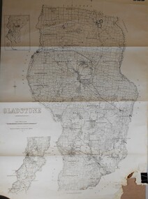
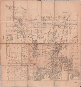
Map - JACK FLYNN COLLECTION: COUNTY OF GLADSTONE, 1934
... JACK FLYNN COLLECTION: COUNTY OF GLADSTONE...Map: County of Gladstone, map sheet showing the whole of the County and the Parishes within. ...Map JACK FLYNN COLLECTION: COUNTY OF GLADSTONE ...Map: County of Gladstone, map sheet showing the whole of the County and the Parishes within. Scale 2 Miles to 1 inch.Engraved at the Department of Lands and Survey Melbourne. 1958. By Authority of W.M. Houston, Government Printermap, gladstone, parish plan, gladstone -
 Tarnagulla History Archive
Photocopies of historic maps - County of Gladstone, including Llanelly & Tarnagulla, varied
... Photocopies of historic maps - County of Gladstone, including Llanelly & Tarnagulla...Photocopies of historic maps - County of Gladstone, including Llanelly & Tarnagulla Stokes & Son ...David Gordon Collection. Two photocopies in clear sleeve. -
Bendigo Historical Society Inc.
Map - SALISBURY WEST, 14/10/1943
... ... County of Gladstone...Map: Salisbury West, County of Gladstone. Parish plan ( number 179 in Map Cupboard 1)...History House 11 Mackenzie Street Bendigo goldfields MAP Gladstone parish plan Salisbury West County of Gladstone Map: Salisbury West, County of Gladstone. ...Map: Salisbury West, County of Gladstone. Parish plan ( number 179 in Map Cupboard 1)map, gladstone, parish plan, salisbury west , county of gladstone -
 Bendigo Historical Society Inc.
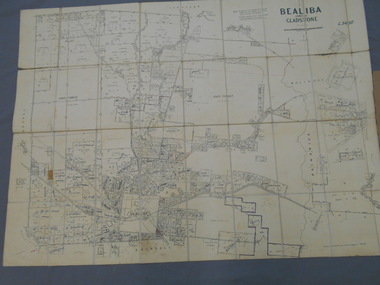
Map - JACK FLYNN COLLECTION: BEALIBA, 15/09/1931
... Map: Parish of Bealiba, County of Gladstone. Parish plan....Photo Lithographed at the Government of Lands and Survey Melbourne. 15.9.31 Map: Parish of Bealiba, County of Gladstone. Parish plan. Map JACK FLYNN COLLECTION: BEALIBA ...Map: Parish of Bealiba, County of Gladstone. Parish plan.By Authority H.J. Green, Government Printer. Photo Lithographed at the Government of Lands and Survey Melbourne. 15.9.31map, gladstone, parish plan, bealiba, gladstone -
 Bendigo Historical Society Inc.
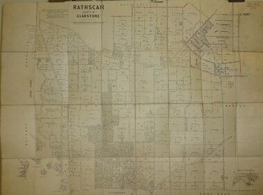
Map - JACK FLYNN COLLECTION: RATHSCAR, 14/09/1935
... Map: Parish of Rathscar, County of Gladstone. Parish plan....History House 11 Mackenzie Street Bendigo goldfields MAP Gladstone parish plan Rathscar Map: Parish of Rathscar, County of Gladstone. Parish plan. Map JACK FLYNN COLLECTION: RATHSCAR ...Map: Parish of Rathscar, County of Gladstone. Parish plan.map, gladstone, parish plan, rathscar -
 Bendigo Historical Society Inc.
Map - JACK FLYNN COLLECTION: EDDINGTON, 1.12.1925
... Map: Parish of Eddington, Counties of Gladstone and Talbot. Parish plan....Butson 1.12.25 Map: Parish of Eddington, Counties of Gladstone and Talbot. Parish plan. Map JACK FLYNN COLLECTION: EDDINGTON ...Map: Parish of Eddington, Counties of Gladstone and Talbot. Parish plan.Dept of Lands and Survey Melbourne by W.J. Butson 1.12.25map, talbot, parish plan, eddington, counties of talbot, gladstone -
 Bendigo Historical Society Inc.
Map - JACK FLYNN COLLECTION: TARNAGULLA SHEET 1, No date visible
... Map: Parish of Tarnagulla Sheet 1, Counties of Gladstone and Bendigo....History House 11 Mackenzie Street Bendigo goldfields MAP Gladstone parish plan Tarnagulla Sheet 1 Map: Parish of Tarnagulla Sheet 1, Counties of Gladstone and Bendigo. Map JACK FLYNN COLLECTION: TARNAGULLA SHEET 1 ...Map: Parish of Tarnagulla Sheet 1, Counties of Gladstone and Bendigo.map, gladstone, parish plan, tarnagulla sheet 1 -
 Bendigo Historical Society Inc.
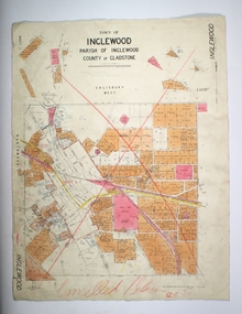
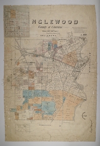
Map - TOWN OF INGLEWOOD, March 1946
... Map: Town of Inglewood, Parish of Inglewood, County of Gladstone. Parish plan...History House 11 Mackenzie Street Bendigo goldfields MAP Gladstone township Inglewood Map: Town of Inglewood, Parish of Inglewood, County of Gladstone. Parish plan Map TOWN OF INGLEWOOD ...Map: Town of Inglewood, Parish of Inglewood, County of Gladstone. Parish planmap, gladstone, township, inglewood -
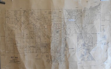 Bendigo Historical Society Inc.
Map - JACK FLYNN COLLECTION: BET BET, 18/08/1931
... Map: Parish of Bet Bet, Counties of Gladstone and Talbot . Parish plan....History House 11 Mackenzie Street Bendigo goldfields MAP Gladstone parish plan Bet Bet Counties of Gladstone and Talbot. By Authority H.J. ...Map: Parish of Bet Bet, Counties of Gladstone and Talbot . Parish plan.By Authority H.J. Green Govt, Printer. Photo Lithographed at the Department of Lands and Survey, Melbourne. 18.8.31map, gladstone, parish plan, bet bet, counties of gladstone and talbot. -
 Bendigo Historical Society Inc.
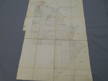
Map - JACK FLYNN COLLECTION: TARNAGULLA SHEET 3, No date visible
... Map: Parish of Tarnagulla Sheet 3, County of Gladstone. Parish plan....History House 11 Mackenzie Street Bendigo goldfields MAP Gladstone parish plan Tarnagulla Sheet 3 Map: Parish of Tarnagulla Sheet 3, County of Gladstone. Parish plan. Map JACK FLYNN COLLECTION: TARNAGULLA SHEET 3 ...Map: Parish of Tarnagulla Sheet 3, County of Gladstone. Parish plan.map, gladstone, parish plan, tarnagulla sheet 3 -
 Bendigo Historical Society Inc.
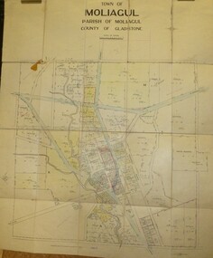
Map - JACK FLYNN COLLECTION: MOLIAGUL, 7/02/1931
... Map: Township of Moliagul, Parish of Moliagul, County of Gladstone. Parish plan....History House 11 Mackenzie Street Bendigo goldfields MAP Gladstone township Moliagul Map: Township of Moliagul, Parish of Moliagul, County of Gladstone. Parish plan. Map JACK FLYNN COLLECTION: MOLIAGUL ...Map: Township of Moliagul, Parish of Moliagul, County of Gladstone. Parish plan.map, gladstone, township, moliagul -
 Bendigo Historical Society Inc.
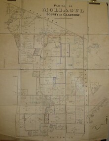
Map - JACK FLYNN COLLECTION: MOLIAGUL, October 1946
... Map: Parish of Moliagul, Sheet 1, County of Gladstone. Parish plan....History House 11 Mackenzie Street Bendigo goldfields MAP Gladstone parish plan Moliagul Map: Parish of Moliagul, Sheet 1, County of Gladstone. Parish plan. Map JACK FLYNN COLLECTION: MOLIAGUL ...Map: Parish of Moliagul, Sheet 1, County of Gladstone. Parish plan.map, gladstone, parish plan, moliagul -
 Bendigo Historical Society Inc.
Map - JACK FLYNN COLLECTION: TARNAGULLA SHEET 4, 25/11/1926
... Map: Parish of Tarnagulla Sheet 4, Counties of Gladstone and Bendigo. Parish plan....Butson. 25.11.26 Map: Parish of Tarnagulla Sheet 4, Counties of Gladstone and Bendigo. Parish plan. Map JACK FLYNN COLLECTION: TARNAGULLA SHEET 4 ...Map: Parish of Tarnagulla Sheet 4, Counties of Gladstone and Bendigo. Parish plan.Photo-Lithographed at the Department of lands and Survey, Melbourne by W. J. Butson. 25.11.26map, gladstone, parish plan, tarnagulla sheet 4 -
 Bendigo Historical Society Inc.
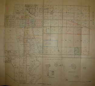
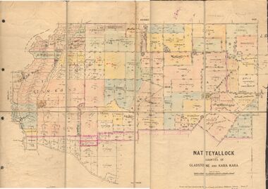
Map - JACK FLYNN COLLECTION: NATTE YALLOCK, 22/06/1937
... Map: Parish of Natte Yallock, Counties of Gladstone and Kara Kara. Parish plan....Map: Parish of Natte Yallock, Counties of Gladstone and Kara Kara. Parish plan. Map JACK FLYNN COLLECTION: NATTE YALLOCK ...Map: Parish of Natte Yallock, Counties of Gladstone and Kara Kara. Parish plan.By Authority H.J. Green Government Printer Melbourne. Drawn and Reproduced at the Depart., of Lands and Survey, Melbourne, Victoria.map, gladstone, parish plan, natte yallock -
Bendigo Historical Society Inc.
Map - TARNAGULLA, Examined May 1883
... Map: Tarnagulla, Counties of Gladstone and bendigo. Parish plan ( number 244 in Map Cupboard 1)...History House 11 Mackenzie Street Bendigo goldfields MAP Gladstone parish plan Tarnagulla Gladstone Map: Tarnagulla, Counties of Gladstone and bendigo. Parish plan ( number 244 in Map Cupboard 1) Map TARNAGULLA ...Map: Tarnagulla, Counties of Gladstone and bendigo. Parish plan ( number 244 in Map Cupboard 1)map, gladstone, parish plan, tarnagulla, gladstone -
Bendigo Historical Society Inc.
Map - SALISBURY WEST, 29/01/1878
... Map: Salisbury West, County of Gladstone. Parish plan (number 305 in map cupboard 1)...History House 11 Mackenzie Street Bendigo goldfields MAP Gladstone parish plan Salisbury West Map: Salisbury West, County of Gladstone. Parish plan (number 305 in map cupboard 1) Map SALISBURY WEST ...Map: Salisbury West, County of Gladstone. Parish plan (number 305 in map cupboard 1)map, gladstone, parish plan, salisbury west -
 Bendigo Historical Society Inc.
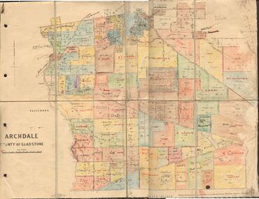
Map - JACK FLYNN COLLECTION: ARCHDALE, 15/01/1936
... Map: Parish of Archdale, County of Gladstone. Parish plan. The Allotments have been coloured in with pencil....Drawn and Reproduced at the Dept, of Lands and Survey, Melbourne, Victoria. 15/01/36 Map: Parish of Archdale, County of Gladstone. Parish plan. The Allotments have been coloured in with pencil. ...Map: Parish of Archdale, County of Gladstone. Parish plan. The Allotments have been coloured in with pencil.By Authority H.J. Green, Government Printer Melbourne. Drawn and Reproduced at the Dept, of Lands and Survey, Melbourne, Victoria. 15/01/36map, gladstone, parish plan, archdale , gladstone -
 Bendigo Historical Society Inc.
Map - INGLEWOOD, 17/12/1877
... Map: Parish of Inglewood, County of Gladstone. Parish plan. Earliest date on map 31/12/75....History House 11 Mackenzie Street Bendigo goldfields MAP Gladstone parish plan Inglewood Map: Parish of Inglewood, County of Gladstone. Parish plan. Earliest date on map 31/12/75. ...Map: Parish of Inglewood, County of Gladstone. Parish plan. Earliest date on map 31/12/75.map, gladstone, parish plan, inglewood -
Bendigo Historical Society Inc.
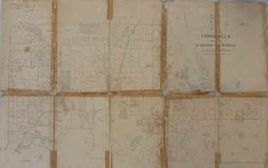
Map - TARNAGULLA SHEET 1, Examined 25/08/1926
... Map: Tarnagulla Sheet 1, Counties of Gladstone and Bendigo. Parish plan (number 304 in map cupboard 1)...History House 11 Mackenzie Street Bendigo goldfields MAP Gladstone parish plan Tarnagulla Map: Tarnagulla Sheet 1, Counties of Gladstone and Bendigo. Parish plan (number 304 in map cupboard 1) Map TARNAGULLA SHEET 1 ...Map: Tarnagulla Sheet 1, Counties of Gladstone and Bendigo. Parish plan (number 304 in map cupboard 1)map, gladstone, parish plan, tarnagulla -
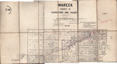 Bendigo Historical Society Inc.
Map - JACK FLYNN COLLECTION: WAREEK, Examined 1918
... Parish of Wareek, Counties of Gladstone and Talbot. Parish plan. Looks like half of the sheet is missing....Parish of Wareek, Counties of Gladstone and Talbot. Parish plan. Looks like half of the sheet is missing. ...Map: L.1053. Parish of Wareek, Counties of Gladstone and Talbot. Parish plan. Looks like half of the sheet is missing.Second Issue. Examined by S.F. Green. July 1918. William J. Swan, Draughtsman, August 1884. Photo-Lithographic Fac-Simile, W 36.map, gladstone, parish plan, wareek -
Tarnagulla History Archive
File containing photocopied extracts from three newspapers
... Extracts are from The Ballarat Courier (1883-1886), County of Gladstone Gazette (1893-1895) and The Dunolly Progress (1895-1896). ...Extracts are from The Ballarat Courier (1883-1886), County of Gladstone Gazette (1893-1895) and The Dunolly Progress (1895-1896). ...David Gordon Collection. Compiled by David Gordon. Extracts are from The Ballarat Courier (1883-1886), County of Gladstone Gazette (1893-1895) and The Dunolly Progress (1895-1896). All extracts reference Tarnagulla. White tape-bound folder. Contains around 70 A3 pages. -
 Bendigo Historical Society Inc.
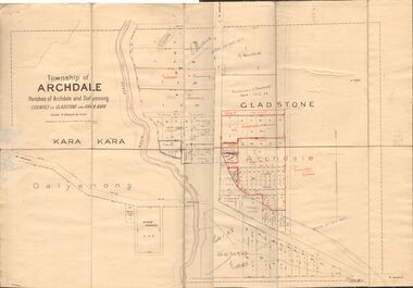
Map - JACK FLYNN COLLECTION: TOWNSHIP OF ARCHDALE, /08/1904
... Map: Township of Archdale, Parishes of Archdale and Dalyenong, Counties of Gladstone and Kara Kara. Scale 4 Chains to 1 Inch. ...Spark Narrister & Solicitor, Formerly Mitchell, Monotti & Spark Map: Township of Archdale, Parishes of Archdale and Dalyenong, Counties of Gladstone and Kara Kara. Scale 4 Chains to 1 Inch. ...Map: Township of Archdale, Parishes of Archdale and Dalyenong, Counties of Gladstone and Kara Kara. Scale 4 Chains to 1 Inch. Has attached letters relating to land transfers between the Estate of Kate Sanderson and Barry Frederick Mortlock also between Matilda Jane Sanderson and A. O. Proctor.J. K. Spark Narrister & Solicitor, Formerly Mitchell, Monotti & Sparkmap, gladstone, township, archdale, dalyenong, gladstone, kara kara -
Bendigo Historical Society Inc.
Map - SALISBURY WEST : COUNTY OF BENDIGO, 3-3-1944
... Salisbury, County of Bendigo, County of Gladstone, Powlett, Yarrayne, Bridgewater, Inglewood, River Loddon, Bullabul Creek, Glenalbyn, Kurting. ...Salisbury, County of Bendigo, County of Gladstone, Powlett, Yarrayne, Bridgewater, Inglewood, River Loddon, Bullabul Creek, Glenalbyn, Kurting. ...Map. Salisbury, County of Bendigo, County of Gladstone, Powlett, Yarrayne, Bridgewater, Inglewood, River Loddon, Bullabul Creek, Glenalbyn, Kurting. By Authority H.E. Daw, Government Printer, Melbourne. Drawn and reproduced at the Department of Lands and Survey, Melbourne., 3-3-1944. Price 5/-. (number 94 in map cupboard 1)H.E. Daw, Government Printer, Melbourne.map, bendigo, salisbury west -
Bendigo Historical Society Inc.
Map - SALISBURY WEST : COUNTY OF BENDIGO, 24-6-24
... Salisbury, County of Bendigo, County of Gladstone, Powlett, Yarrayne, Bridgewater, Inglewood, Glenalbyn, Kurting, River Loddon, Bulabul Creek. ...Salisbury, County of Bendigo, County of Gladstone, Powlett, Yarrayne, Bridgewater, Inglewood, Glenalbyn, Kurting, River Loddon, Bulabul Creek. ...Map. Salisbury, County of Bendigo, County of Gladstone, Powlett, Yarrayne, Bridgewater, Inglewood, Glenalbyn, Kurting, River Loddon, Bulabul Creek. By authority A.J. Mullett, Government Printer, Melbourne. Photo-Lithographed at the Department of Lands and Survey, Melbourne by W.J. Butson, 24-6-24. Price 1/-. (number 116 in map cupboard 1)A.J. Mullett, Government Printer, Melbourne.map, bendigo, salisbury west -
 Bendigo Historical Society Inc.
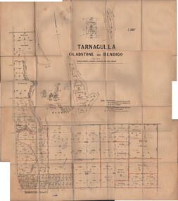
Map - JACK FLYNN MAP COLLECTION: GLADSTONE AND BENDIGO - TARNAGULLA, 13th May 1922
... Map 388. Counties of Gladstone and Bendigo a Map of Tarnagulla with Kingower, Glenalbyn, Inglewood, Waanyarra and Laanecoorie boarding. ...Butson. 13.5.22 Map 388. Counties of Gladstone and Bendigo a Map of Tarnagulla with Kingower, Glenalbyn, Inglewood, Waanyarra and Laanecoorie boarding. ...Map 388. Counties of Gladstone and Bendigo a Map of Tarnagulla with Kingower, Glenalbyn, Inglewood, Waanyarra and Laanecoorie boarding. The map is in poor condition and in several pieces. It has been previously taped together. The front page is of red card with white tape along the spine to hold it together, top half Tarnagulla is hand written in black lead on a label with blue trim.By Authority A.J. Mullett, Government Printer, Melbourne. Photo-Lithographed at the Department of Lands and Survey, Melbourne by W.J. Butson. 13.5.22map, bendigo, tarnagulla, tarnagulla, kingower, glenalbyn, laanecoorie, inglewood. -
Bendigo Historical Society Inc.
Map - POWLETT : COUNTY OF BENDIGO, 2-12-15
... Powlett, County of Bendigo, County of Gladstone, Janiember West, Janiember East, Yarrayne, Salisbury West, Kurting, Korong, River Loddon. ...Powlett, County of Bendigo, County of Gladstone, Janiember West, Janiember East, Yarrayne, Salisbury West, Kurting, Korong, River Loddon. ...Map. Powlett, County of Bendigo, County of Gladstone, Janiember West, Janiember East, Yarrayne, Salisbury West, Kurting, Korong, River Loddon. By Authority Albert J. Mullett, Government Printer, Melbourne. Photographed at the Department of Lands and Survey, Melbourne by W. J. Butson.2-12-15. Price 1/-. (number 119 in map cupboard 1)Albert J. Mullett, Government Printermap, bendigo, powlett -
 Bendigo Historical Society Inc.
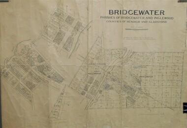
Map - JACK FLYNN COLLECTION: BRIDGEWATER, 10/09/1931
... Map: Bridgewater, Parishes of Bridgewater and Inglewood, Counties of Bendigo and Gladstone. Parish plan....History House 11 Mackenzie Street Bendigo goldfields MAP Bendigo parish plan Bridgewater Inglewood Map: Bridgewater, Parishes of Bridgewater and Inglewood, Counties of Bendigo and Gladstone. Parish plan. Map JACK FLYNN COLLECTION: BRIDGEWATER ...Map: Bridgewater, Parishes of Bridgewater and Inglewood, Counties of Bendigo and Gladstone. Parish plan.map, bendigo, parish plan, bridgewater inglewood -
Bendigo Historical Society Inc.
Map - BRIDGEWATER, 10/09/1913
... Map: Bridgewater, Parishes of Bridgewater and Inglewood, Counties of Bendigo and Gladstone (number 276 in map cupboard 1)...History House 11 Mackenzie Street Bendigo goldfields MAP Bendigo parish plan Bridgewater Map: Bridgewater, Parishes of Bridgewater and Inglewood, Counties of Bendigo and Gladstone (number 276 in map cupboard 1) Map BRIDGEWATER ...Map: Bridgewater, Parishes of Bridgewater and Inglewood, Counties of Bendigo and Gladstone (number 276 in map cupboard 1)map, bendigo, parish plan, bridgewater