Showing 135 items matching " dept. of lands "
-
 Tarnagulla History Archive
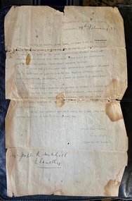
Letter from Dept of Lands and Survey to Joseph Mitchell regarding signage on leasehold property, 1923
... Letter from Dept of Lands and Survey to Joseph Mitchell regarding signage on leasehold property, 1923....Letter from Dept of Lands and Survey to Joseph Mitchell regarding signage on leasehold property, 1923. ... -
 Lakes Entrance Historical Society
Map - Glenaladale County of Tanjil, Dept of Lands and Survey
... Dept of Lands and Survey...Insert map of township of Iguana Map Glenaladale County of Tanjil Dept of Lands and Survey ...Shows landowners, roads, Mitchell River, Woolshed Creek, Cobbannan Creek. Insert map of township of Iguanawaterways, roads and streets, landowners, township -
Lakes Entrance Historical Society
Map - County of Tanjil, Dept of Lands and Survey
... Dept of Lands and Survey...Map County of Tanjil Dept of Lands and Survey ...Shows towns from Maffra to Colquoun, Lake Wellington, Lake Victoria, Lake King, Bass Strait.townships, waterways -
Lakes Entrance Historical Society
Map - Bingo-Munjie County of Bogong, Dept of Lands and Survey
... Dept of Lands and Survey...Bingo-Munjie South insert diagram showing Triangulation of Parish Map Bingo-Munjie County of Bogong Dept of Lands and Survey ...Shows landowners of Coloungra, OImeo, Bingo-Munjie South. Bingo-Munjie South insert diagram showing Triangulation of Parishland settlement -
Lakes Entrance Historical Society
Map - Thorkidaan Counties of Tambo and Benambra, Dept of Lands and Survey
... Dept of Lands and Survey...Moonip, Reserved forest, Benambra land owners Map Thorkidaan Counties of Tambo and Benambra Dept of Lands and Survey ...Shows Hinno-Munjie, Cuttamurra. Euccmbene, Tambo, County of Dargo. Moonip, Reserved forest, Benambra land ownersland settlement, forest -
Lakes Entrance Historical Society
Map - Boorolite County of Wonnangatta, AC Brooks Gov. Printer
... ...Dept of Lands and Survey...Lakes Entrance Historical Society 4 Marine Parade Lakes Entrance gippsland Land Settlement Waterways Shows land owners County of Delatite, Changue, Howgua, Howgua River, Timbertop Creek Map Boorolite County of Wonnangatta AC Brooks Gov. Printer Dept of Lands and Survey ...Shows land owners County of Delatite, Changue, Howgua, Howgua River, Timbertop Creekland settlement, waterways -
Lakes Entrance Historical Society
Map - Benambra, Dept of Lands and Survey
... Dept of Lands and Survey...Lakes Entrance Historical Society 4 Marine Parade Lakes Entrance gippsland Land Settlement Waterways Forest County Northern Section Sheet 1 Shows Indi River, Murray River showing agricultural and grazing land, pastural land, swamp land, State forests, Timber reserves. Map Benambra Dept of Lands and Survey ...Shows Indi River, Murray River showing agricultural and grazing land, pastural land, swamp land, State forests, Timber reserves.County Northern Section Sheet 1land settlement, waterways, forest -
Lakes Entrance Historical Society
Map - Dargo, Dept of Lands and Survey
... Dept of Lands and Survey...Lakes Entrance Historical Society 4 Marine Parade Lakes Entrance gippsland Land Settlement Waterways Shows areas from Benambra, Bongong to Tanjil, Wongurra River Map Dargo Dept of Lands and Survey ...Shows areas from Benambra, Bongong to Tanjil, Wongurra Riverland settlement, waterways -
Lakes Entrance Historical Society
Map - Tambo Counties of Dargo and Tambo, A C Brooks Gov. Printer
... ...Dept of Lands and Survey...Lakes Entrance Historical Society 4 Marine Parade Lakes Entrance gippsland Townships Roads and Streets Land Settlement Waterways Shows townships of Bruthen, Dargo, Tambo River, Omeo Highway, Land owners Map Tambo Counties of Dargo and Tambo A C Brooks Gov. Printer Dept of Lands and Survey ...Shows townships of Bruthen, Dargo, Tambo River, Omeo Highway, Land ownerstownships, roads and streets, land settlement, waterways -
Lakes Entrance Historical Society
Map - Boole Poole County of Tanjil, Dept of Lands and Survey, 1965
... Dept of Lands and Survey...Map Boole Poole County of Tanjil Dept of Lands and Survey ...Shows landowners named on Boole Poole. The Lakes National Park, Sperm Whale Head, Lake Victoria, Seacombe. 2 pages A and B and four photocopies.landowners, waterways, parks, land settlement -
Lakes Entrance Historical Society
Map - Allotments Township of Cunninghame, Dept of Lands and Survey
... Dept of Lands and Survey...Lakes Entrance Historical Society 4 Marine Parade Lakes Entrance gippsland Map is pasted together with properties Lake Tyers Auction Land Development Townships Islands Colquhoun Counties of Tambo and Tanjil Map shows selections of allotments in the towns of Cunninghame and Kalimna including Rigby Island and Fraser Island Map Allotments Township of Cunninghame Dept of Lands and Survey ...Map is pasted together with properties Lake Tyers AuctionMap shows selections of allotments in the towns of Cunninghame and Kalimna including Rigby Island and Fraser IslandColquhoun Counties of Tambo and Tanjilland development, townships, islands -
Lakes Entrance Historical Society
Map - Electoral Divisions of Gippsland 1962, Dept of Lands and Survey, 1962
... Dept of Lands and Survey...Map Electoral Divisions of Gippsland 1962 Dept of Lands and Survey A C Brooks Govv. Printer ...Map of proposed Commonwealth electoral divisions of Gippsland showing boundaries and names of Parishes.Proposed Division of Gippslandsettlement, government planning -
Lakes Entrance Historical Society
Map - Newmerella County of Tambo Sheet 1, Dept of Lands and Survey, September 1951
... Dept of Lands and Survey...Lakes Entrance Historical Society 4 Marine Parade Lakes Entrance gippsland land owners Waterways Map shows land owners, Lake Corringle, Snowy River, Bass Strait Map Newmerella County of Tambo Sheet 1 Dept of Lands and Survey ...Map shows land owners, Lake Corringle, Snowy River, Bass Straitland owners, waterways -
 Lakes Entrance Historical Society
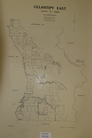
Map - Gelantipy East County of Tambo, Dept of Lands and Survey
... Dept of Lands and Survey...East Deddick County of Croajingolong Map Gelantipy East County of Tambo Dept of Lands and Survey ...Shows land owners of Gelantipy West, Maroo, Deterka, Woongulmerang. East Deddick County of Croajingolongland settlement, waterways -
Lakes Entrance Historical Society
Map - Bumberrah Counties of Dargo and Tambo. Colquhoun Counties of Tambo and Tanjil, Dept of Lands and Survey, 1918
... Dept of Lands and Survey...Colquhoun Counties of Tambo and Tanjil Dept of Lands and Survey ...Two maps joined together showing landowners, forests, Bass Strait, Lake King, Tambo Bluff.landowners, waterways, forest, shoreline -
Lakes Entrance Historical Society
Map - Township of Lakes Entrance Parish of Colquhoun 1917, Dept of Lands and Survey, 11/7/1917
... Dept of Lands and Survey...Two pages A and B Map Township of Lakes Entrance Parish of Colquhoun 1917 Dept of Lands and Survey ...Shows landowners, roads, Reeves river township of Lakes Entrance. Two pages A and B -
 Bendigo Historical Society Inc.
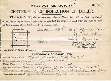
Document - MCCOLL, RANKIN AND STANISTREET COLLECTION: NORTH HUSTLERS GMC NL, 1934 - 1940
... ... Dept. of Lands & Survey Permissive Occupancy agreement...Envelope contains: - Dept. of Lands and Survey Permissive Occupancy agreement & receipts, Fire Policy, Cert. of Inspection of Boiler, Insurance Policies, Crown Land Receipts. ...Envelope contains: - Dept. of Lands and Survey Permissive Occupancy agreement & receipts, Fire Policy, Cert. of Inspection of Boiler, Insurance Policies, Crown Land Receipts. ...Document. Envelope contains: - Dept. of Lands and Survey Permissive Occupancy agreement & receipts, Fire Policy, Cert. of Inspection of Boiler, Insurance Policies, Crown Land Receipts. Right No. 4827 Eaglehawk. Pressure Gauge readings from Russell & Russell, manufacturer of Steam Vacuum and Compound Gauges dated 25th August 1939.McColl, Rankin & Stanistreetorganization, business, gold mine, mccoll, rankin & stanistreet, north hustlers gmc nl, gold mining, dept. of lands & survey permissive occupancy agreement, fire policy, state accident insurance mine policies -
Whitehorse Historical Society Inc.
Map, Nunawading. County of Bourke, 1878
... On Verso: Copied from the most up to date by the Dept of Lands, 1878. Laid before the Executive Council, 11 June 1878. ...On Verso: Copied from the most up to date by the Dept of Lands, 1878. Laid before the Executive Council, 11 June 1878. ...On Verso: Copied from the most up to date by the Dept of Lands, 1878. Laid before the Executive Council, 11 June 1878. ...Photocopy of map of Shire of Nunawading.Photocopy of map of Shire of Nunawading. Note: Fosters v President of the Shire of Nunawading. On Verso: Copied from the most up to date by the Dept of Lands, 1878. Laid before the Executive Council, 11 June 1878. Shows land holders.Photocopy of map of Shire of Nunawading.shire of nunawading, maps -
Bendigo Historical Society Inc.
Map - PARISH OF SANDHURST 1961, 1961
... Dept of Lands and Survey...History House 11 Mackenzie Street Bendigo goldfields BHS Collection BENDIGO Land sales parish map Dept of Lands and Survey At Bendigo Parish of Sandhurst. ...BHS CollectionAt Bendigo Parish of Sandhurst. Sheet 13Dept of Lands and Surveybendigo, land sales, parish map -
Bendigo Historical Society Inc.
Map - PARISH OF SANDHURST 1961, 1961
... Dept of Lands and Survey...History House 11 Mackenzie Street Bendigo goldfields BHS Collection BENDIGO Land sales parish map Dept of Lands and Survey At Bendigo Parish of Sandhurst. ...BHS CollectionAt Bendigo Parish of Sandhurst. Sheet F.Dept of Lands and Surveybendigo, land sales, parish map -
 Wodonga & District Historical Society Inc
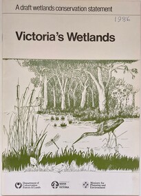
Book - Victoria's Wetlands, Dept. of Conservation, Forests & Lands, 1986
... Dept. of Conservation, Forests & Lands...On foot of cover: Department of Conservation, Forests & Lands, Department of Water Resources, Victoria, Ministry for Planning and Environment An 22 page book containing maps and illustrations Victoria's Wetlands Book Victoria's Wetlands Dept. of Conservation, Forests & Lands ...This publication was the result of an inquiry into the state of wetland environments in Victoria. It produced a draft strategy for conservation of threatened areas in the future.An 22 page book containing maps and illustrationsThis publication was the result of an inquiry into the state of wetland environments in Victoria. It produced a draft strategy for conservation of threatened areas in the future.wetland protection, wetlands victoria, water conservation -
 Bendigo Historical Society Inc.
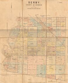
Map - JACK FLYNN COLLECTION: DERBY, 1/09/1909
... Dept of Lands and Survey, Melbourne by T.E.McGauran 1.9.09...History House 11 Mackenzie Street Bendigo goldfields MAP Bendigo parish plan Derby Dept of Lands and Survey, Melbourne by T.E.McGauran 1.9.09 Map: Derby, County of Bendigo. ...Map: Derby, County of Bendigo. Parish plan.Dept of Lands and Survey, Melbourne by T.E.McGauran 1.9.09map, bendigo, parish plan, derby -
 Federation University Historical Collection
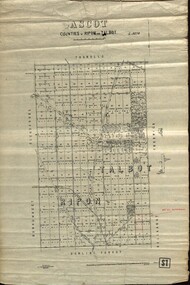
Plan - map, Ascot: Counties of Ripon and Talbot, 18/12/1920
... Photo-Lithographed at the Dept. of Lands and Survey....Photo-Lithographed at the Dept. of Lands and Survey. Ascot: Counties of Ripon and Talbot Plan map W.J.Butson ...Cadastral map showing parish boundaries and land ownership. "L5270"Maps parishes located in Ascot area. Photo-Lithographed at the Dept. of Lands and Survey.Highlighted parish labelled, Mrs E.C.Sutherland.parish, map, ascot, counties, e. c. sutherland, a. cameron, sweeney, w. j. clarke, mount hollowback, tourello, burrumbeet, glendaruel, dowling forest, a. j. mullett, w. j. butson, 1920, william coghill, chatham, chatham family collection, mrs e.c.sutherland. -
 Bendigo Historical Society Inc.
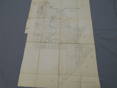
Map - JACK FLYNN COLLECTION: EDDINGTON, 1.12.1925
... Dept of Lands and Survey Melbourne by W.J. Butson 1.12.25...History House 11 Mackenzie Street Bendigo goldfields MAP Talbot parish plan Eddington Counties of Talbot Gladstone Dept of Lands and Survey Melbourne by W.J. Butson 1.12.25 Map: Parish of Eddington, Counties of Gladstone and Talbot. ...Map: Parish of Eddington, Counties of Gladstone and Talbot. Parish plan.Dept of Lands and Survey Melbourne by W.J. Butson 1.12.25map, talbot, parish plan, eddington, counties of talbot, gladstone -
Port Melbourne Historical & Preservation Society
Map - Port Melbourne, Department of Lands and Survey, 20 Sep 1932
... Dept. of Lands and Survey Map Sheet 5 Port Melbourne, Parish of South Melbourne....Port Melbourne Historical & Preservation Society Port Melbourne Town Hall 333 Bay Street Port Melbourne melbourne Town Planning Sandridge Lagoon Melbourne Harbor Trust - Port of Melbourne Authority Transport - Railways Annotated re MHT precincts on foreshore:Plan sketches re boat harbour Dept. of Lands and Survey Map Sheet 5 Port Melbourne, Parish of South Melbourne. ...Dept. of Lands and Survey Map Sheet 5 Port Melbourne, Parish of South Melbourne.Annotated re MHT precincts on foreshore:Plan sketches re boat harbourtown planning, sandridge lagoon, melbourne harbor trust - port of melbourne authority, transport - railways -
 Bendigo Historical Society Inc.
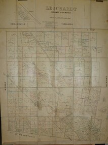
Map - JACK FLYNN COLLECTION: LEICHARDT, 14/03/1`939
... Drawn and Reproduced at the Dept, of Lands and Survey, Melbourne, Victoria. 14.3.1939...History House 11 Mackenzie Street Bendigo goldfields MAP Bendigo parish plan Leichardt Drawn and Reproduced at the Dept, of Lands and Survey, Melbourne, Victoria. 14.3.1939 Map: Parish of Leichardt, County of Bendigo. ...Map: Parish of Leichardt, County of Bendigo. Parish plan.Drawn and Reproduced at the Dept, of Lands and Survey, Melbourne, Victoria. 14.3.1939map, bendigo, parish plan, leichardt -
 Kiewa Valley Historical Society
Maps - Tourist
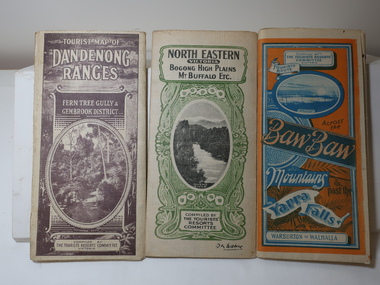
... Green - 6 pence. Dept of Lands and Survey, Melbourne...Green - 6 pence. Dept of Lands and Survey, Melbourne 3 Tourist location maps (folded) and printed on parchment. 1. ...These maps were all dated 1933 which was before the construction of the Kiewa Hydro Electric Scheme and when Tawonga was spelt Towonga. North East Victoria in 1933 was before the construction of the Kiewa Hydro Electric Scheme so the townships of Mt Beauty and Bogong are not shown. The description of the Snow Lines was important as skiers, bushwalkers and campers relied on them. The details on the map include "ADB. Numbered from A.1-377 round plates. CD Numbered from C 1-235 square plates. Poles about 3 chains apart 27 to the mile." 3 Tourist location maps (folded) and printed on parchment. 1. Tourist map of the Dandenong Ranges. Brown cover. dated 6-4-33. Govt. printer showing roads, tracks in red and heights of the land. 2. Tourist Map of Warburton, Mt Baw Baw, and Walhalla. Blue and Orange cover. dated 23-5-33 Govt. printer. 3 different maps of each area showin roads, tracks and timber tramways.Also in red and blue. 3. Tourist Map of North Eastern Victoria including Bogong High Plains Mt Buffalo Etc. Green cover. dated June 1933 Govt. printer. Main map and insert titled Bogong High Plains. Showing roads , tracks and tram ways. On insert showing snow poles. Also Red and Blue and mountains.By Authority of H.J. Green - 6 pence. Dept of Lands and Survey, Melbourne1933 maps, tourism maps, bogong high plains map 1933, snow poles -
Port Melbourne Historical & Preservation Society
Plan - Proposed land sub-division, west of railway, Sandridge, 19 Nov 1866
... Noone (Photolithographer, Dept. of Lands and Survey) J. Hardy (Assistant Surveyor)...Noone (Photolithographer, Dept. of Lands and Survey) J. Hardy (Assistant Surveyor) 1866 plan of proposed sub-division of land at Sandridge, west of railway. ...1866 plan of proposed sub-division of land at Sandridge, west of railway. Includes manure depot.J. Noone (Photolithographer, Dept. of Lands and Survey) J. Hardy (Assistant Surveyor)town planning, town planning - proposals shelved, j noone, j hardy -
 Bendigo Historical Society Inc.
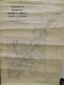
Map - JACK FLYNN COLLECTION: HUNTLY, 12.03.1932
... Photo-Lithographed at the Dept., of Lands and Survey, Melbourne. 12.3.32...Photo-Lithographed at the Dept., of Lands and Survey, Melbourne. 12.3.32 Map: Township of Huntly, Parish of Huntly , County of Bendigo. ...Map: Township of Huntly, Parish of Huntly , County of Bendigo. Parish plan. Western and South Riding Division on Main St. (Main Northern Highway) - written in ink below name of map.BY Authority H.J. Green. Photo-Lithographed at the Dept., of Lands and Survey, Melbourne. 12.3.32map, bendigo, township, huntly -
 Bendigo Historical Society Inc.
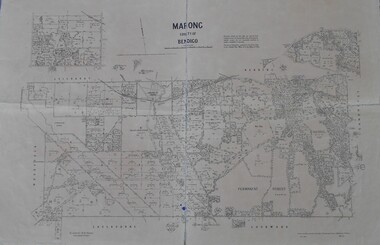
Map - Marong County of Bendigo
... Drawn and reproduced at the Dept. of Lands and Survey, Melbourne. By authority: W.M. ...Drawn and reproduced at the Dept. of Lands and Survey, Melbourne. By authority: W.M. ...Map of Marong. Drawn and reproduced at the Dept. of Lands and Survey, Melbourne. By authority: W.M. Houston Government Printer. June 1953.On the back in blue pen: certified plan parish Marong, signed minister and seal affixed for land S sec.72 evidence act. I certify that this a true plan parish Marong (signature illegible) minister for lands.map, marong