Showing 17 items matching " diggorra "
-
 Bendigo Historical Society Inc.
Map - DIGGORRA, 26/04/1880
... DIGGORRA......Diggorra...Map: Diggorra, County of Bendigo. Parish plan ( number 237 in Map Cupboard 1)...History House 11 Mackenzie Street Bendigo goldfields MAP Bendigo parish plan Diggorra Map: Diggorra, County of Bendigo. Parish plan ( number 237 in Map Cupboard 1) Map DIGGORRA ...Map: Diggorra, County of Bendigo. Parish plan ( number 237 in Map Cupboard 1)map, bendigo, parish plan, diggorra -
Bendigo Historical Society Inc.
Map - PARISH OF DIGGORRA, 23/02/1911
... ...Diggorra...Map: Parish of Diggorra, County of Bendigo. Parish plan ( number 247 in Map Cupboard 1)...History House 11 Mackenzie Street Bendigo goldfields MAP Bendigo parish plan Diggorra Map: Parish of Diggorra, County of Bendigo. ...Map: Parish of Diggorra, County of Bendigo. Parish plan ( number 247 in Map Cupboard 1)map, bendigo, parish plan, diggorra -
Bendigo Historical Society Inc.
Map - PORTION OF ELMORE ESTATE, 19/10/1920
... ... Diggorra ...Map: Portion of Elmore Estate, Parishes of Warragamba and Diggorra, County of Bendigo. Parish plan Canvas backed ( number 143 in Map Cupboard 1)...History House 11 Mackenzie Street Bendigo goldfields MAP Bendigo rural Elmore Estate Warragamba Diggorra County of Bendigo. Map: Portion of Elmore Estate, Parishes of Warragamba and Diggorra, County of Bendigo. ...Map: Portion of Elmore Estate, Parishes of Warragamba and Diggorra, County of Bendigo. Parish plan Canvas backed ( number 143 in Map Cupboard 1)map, bendigo, rural, elmore estate , warragamba, diggorra , county of bendigo. -
Bendigo Historical Society Inc.
Map - BURNEWANG PARK ESTATE, circa 1920
... ... Diggorra...Map: Burnewang Park Estate, Parishes of Diggorra and Minto, County of Bendigo, Parish Plan ,Canvas backed ( number 127 in Map Cupboard 1)...History House 11 Mackenzie Street Bendigo goldfields MAP Bendigo rural Burnewang Diggorra Minto County of Bendigo Map: Burnewang Park Estate, Parishes of Diggorra and Minto, County of Bendigo, Parish Plan ,Canvas backed ( number 127 in Map Cupboard 1) Map BURNEWANG PARK ESTATE ...Map: Burnewang Park Estate, Parishes of Diggorra and Minto, County of Bendigo, Parish Plan ,Canvas backed ( number 127 in Map Cupboard 1)map, bendigo, rural, burnewang, diggorra, minto, county of bendigo -
Bendigo Historical Society Inc.
Map - DIGGORRA : COUNTY OF BENDIGO, 26-6-36
... ...diggorra...Map. Parish of Diggorra, County of Bendigo, Parish of Ballendella, Parish of Pannoobamawm, Pannoomilloo, Rochester West, Warragamba, Minto, Egerton, Elmore, Northern Railway to Echuca, Elmore and Cohuna Railway, Township of Elmore. ...(number 58 in map cupboard 1) Map DIGGORRA : COUNTY OF BENDIGO. ...Map. Parish of Diggorra, County of Bendigo, Parish of Ballendella, Parish of Pannoobamawm, Pannoomilloo, Rochester West, Warragamba, Minto, Egerton, Elmore, Northern Railway to Echuca, Elmore and Cohuna Railway, Township of Elmore. By authority H.J. Green, Govt. Printer. Photo-Lithographed at the Deptartment of Lands and Survey, Melbourne. 26-5-36. (number 58 in map cupboard 1)H.J. Green, Govt. Printer.map, bendigo, diggorra -
Bendigo Historical Society Inc.
Map - DIGGORRA PARISH : COUNTY OF BENDIGO, 6-9-21
... ...diggorra...Map. Parish of Diggorra, County of Bendigo, Parish of Bamawm, Rochester West, Pannoomilloo, Warragamba, Minto, Egerton, Elmore, Northern Railway, Parish of Ballendella. ...History House 11 Mackenzie Street Bendigo goldfields MAP Bendigo diggorra A.J. Mullett, Government Printer. Map. ...Map. Parish of Diggorra, County of Bendigo, Parish of Bamawm, Rochester West, Pannoomilloo, Warragamba, Minto, Egerton, Elmore, Northern Railway, Parish of Ballendella. Elmore /Cohuna Railway. Photo-Lithographed at the Department of Lands and Survey, Melbourne by W.J. Butson, 6-9-21, Price 1/-.. By authority A.J. Mullett, Government Printer. (number 57 in map cupboard 1)A.J. Mullett, Government Printer.map, bendigo, diggorra -
 Bendigo Historical Society Inc.
Map - MAP. WARRAGAMBA. COUNTY OF BENDIGO, 1915
... Pannoomilloo. Minto. Diggorra. Kamarooka Photographedat the Department of LANDS AND Survey Melbourne by W. ...Pannoomilloo. Minto. Diggorra. Kamarooka Photographedat the Department of LANDS AND Survey Melbourne by W. ...Map. Warragamba. Colunty of Bendigo. Pannoomilloo. Minto. Diggorra. Kamarooka Photographedat the Department of LANDS AND Survey Melbourne by W. J. Butson. -
 Bendigo Historical Society Inc.
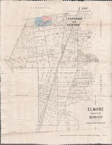
Map - MAP. ELMORE COUNTY OF BENDIGO, 1918
... Elmore County of Bendigo. Diggorra. Burnewang. Ryunnymead. Egerton Photo-Lithographed at the Department of lands and Survey Melbourne, by W. ...Elmore County of Bendigo. Diggorra. Burnewang. Ryunnymead. Egerton Photo-Lithographed at the Department of lands and Survey Melbourne, by W. ...Map. Elmore County of Bendigo. Diggorra. Burnewang. Ryunnymead. Egerton Photo-Lithographed at the Department of lands and Survey Melbourne, by W. J. Button. 4.7.18 -
Bendigo Historical Society Inc.
Map - PANNOOMILLOO : COUNTY OF BENDIGO, 1957
... Pannoomilloo, County of Bendigo, Pannoobamawm, Milloo, Warragamba, Diggorra, Property Allotments. Drawn and Reproduced at the Department of Lands and Survey,1957. ...Pannoomilloo, County of Bendigo, Pannoobamawm, Milloo, Warragamba, Diggorra, Property Allotments. Drawn and Reproduced at the Department of Lands and Survey,1957. ...Map. Pannoomilloo, County of Bendigo, Pannoobamawm, Milloo, Warragamba, Diggorra, Property Allotments. Drawn and Reproduced at the Department of Lands and Survey,1957. Price 2/-. (number 412 in Map Cupboard 1 ).W.M. Houston, Government Printer, Melbourne.bendigo, hospital -
Bendigo Historical Society Inc.
Map - PANNOOMILLOO : COUNTY OF BENDIGO, 17-12-13
... Pannoomilloo, County of Bendigo, Pannoobamawm, Warragamba, Milloo, Diggorra. Photo-Lithographed at the Department of Lands and Survey, Melbourne by W.J. ...Pannoomilloo, County of Bendigo, Pannoobamawm, Warragamba, Milloo, Diggorra. Photo-Lithographed at the Department of Lands and Survey, Melbourne by W.J. ...Map. Pannoomilloo, County of Bendigo, Pannoobamawm, Warragamba, Milloo, Diggorra. Photo-Lithographed at the Department of Lands and Survey, Melbourne by W.J. Butson 17-12-13, Price 1/-. (number 82 in map cupboard 1)W.J. Butson.map, bendigo, pannoomilloo -
Bendigo Historical Society Inc.
Map - BAMAWM : COUNTY OF BENDIGO, 19-8-24
... Bamawm, County of Bendigo, Turrumberry, Pannoobamawm, Diggorra, Ballendella, Millewa. Photo-Lithographed at the Department of Lands and Survey, Melbourne by W.J. ...Bamawm, County of Bendigo, Turrumberry, Pannoobamawm, Diggorra, Ballendella, Millewa. Photo-Lithographed at the Department of Lands and Survey, Melbourne by W.J. ...Map. Bamawm, County of Bendigo, Turrumberry, Pannoobamawm, Diggorra, Ballendella, Millewa. Photo-Lithographed at the Department of Lands and Survey, Melbourne by W.J. Butson, 19-8-24, Price 1/-. (number 50 in map cupboard 1)W.J. Butsonmap, bendigo, bamawm -
Bendigo Historical Society Inc.
Map - PANNOOMILLOO : COUNTY OF BENDIGO, 1957
... Pannoomilloo, County of Bendigo, Milloo, Warragamba, Diggorra, Pannoobamawm. Drawn and reproduced at the Department of Lands and Survey, Melbourne,1957. ...Pannoomilloo, County of Bendigo, Milloo, Warragamba, Diggorra, Pannoobamawm. Drawn and reproduced at the Department of Lands and Survey, Melbourne,1957. ...Map. Pannoomilloo, County of Bendigo, Milloo, Warragamba, Diggorra, Pannoobamawm. Drawn and reproduced at the Department of Lands and Survey, Melbourne,1957. Price 2/-. By Appointment W.M. Houston, Government Printer, Melbourne. (number 3 in map cupboard 1)W.M. Houston, Government Printermap, bendigo, pannoomilloo -
Bendigo Historical Society Inc.
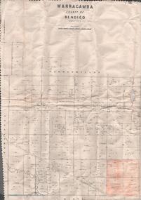
Map - WARRAGAMBA : COUNTY OF BENDIGO, 29-4-30
... Warragamba, County of Bendigo, Pannoomilloo, Kamarooka, Minto, Diggorra. By authority H.J. Green, Government Printer. ...Warragamba, County of Bendigo, Pannoomilloo, Kamarooka, Minto, Diggorra. By authority H.J. Green, Government Printer. ...Map. Warragamba, County of Bendigo, Pannoomilloo, Kamarooka, Minto, Diggorra. By authority H.J. Green, Government Printer. Piccaninny Creek. Drawn and reproduced at the Deparment of Lands and Survey, Melbourne. 29-3-30. Price2/-. (number 10 in map cupboard 1)H.J. Green, Government Printermap, bendigo, warragamba -
Bendigo Historical Society Inc.
Map - PANNOOMILLOO : COUNTY OF BENDIGO, 1957
... Pannoomilloo, County of Bendigo, Pannoobamawm, Milloo, Diggorra, Warragamba. Elmore Cohuna Railway. ...Pannoomilloo, County of Bendigo, Pannoobamawm, Milloo, Diggorra, Warragamba. Elmore Cohuna Railway. ...Map. Pannoomilloo, County of Bendigo, Pannoobamawm, Milloo, Diggorra, Warragamba. Elmore Cohuna Railway. Waranga Mallee Channel. By authority W.M. Houston, Government Printer, Melbourne. Drawn and reproduced at the Department of Lands and Survey, Melbourne 1957. Price 2/-. (number 83 in map cupboard 1)W.M. Houston, Government Printer, Melbourne.map, bendigo, pannoomilloo -
Bendigo Historical Society Inc.
Map - EGERTON : COUNTY OF BENDIGO, 1-3-30
... Egerton, County of Bendigo, Minto, Diggorra, Elmore, Nolan, Goornong, Bagshot, Whirrakee. ...Egerton, County of Bendigo, Minto, Diggorra, Elmore, Nolan, Goornong, Bagshot, Whirrakee. ...Map. Egerton, County of Bendigo, Minto, Diggorra, Elmore, Nolan, Goornong, Bagshot, Whirrakee. Bendigo Creek. By authority J.J. Green, Govt. Printer. Photo-Lithographed at the Department of Lands and Survey, Melbourne. Price 2/-. 1-3-30. (number 47 in map cupboard 1)J.J. Green, Govt. Printer.map, bendigo, egerton -
Bendigo Historical Society Inc.
Map - BAMAWM : COUNTY OF BENDIGO, November 1954
... Sheet 2, Pannoobamawm, Diggorra. Elmore to Cohuna Railway Line. Township of Lockington. ...Sheet 2, Pannoobamawm, Diggorra. Elmore to Cohuna Railway Line. Township of Lockington. ...Map. Bamawm, County of Bendigo. Sheet 2, Pannoobamawm, Diggorra. Elmore to Cohuna Railway Line. Township of Lockington. By authority W.M. Houston, Government Printer.Drawn and reproduced at the Department of Lands and Survey, Melbourne. November 1954. Price 5/- per sheet. (number 52 in map cupboard 1)W.M. Houston, Government Printermap, bendigo, bamawm -
Bendigo Historical Society Inc.
Map - BENDIGO, 1916
... Bendigo, Gunbower, Gladstone, Talbot, Dalhousie, Rodney, Jarklan, Calivil, Hayanmi, Mitiamo, Wanurp, Pannoobamawm, Bamawm, Millewa, Ballendella, Janiember West, Janiember East, Pompapiel, Talambe, Dingee, Milloo, Pannoomilloo, Rochester West, Yarrayne, Salisbury, Yallook, Tandarra, Kamarooka, Warragamba, Diggorra, Minto, Bridgewater, Yarraberb, Neilborough, Whirrakee, Egerton, Elmore, Nolan, Goornong, Bagshot, Huntly, Derby, Leichardt, Nerring, Tarnagulla, Woodstock, Marong, Sandhurst, Wellsford, Bendigo, Axedale, Strathfieldsaye, Eppalock, Kimbolton, Lyell, Sedgwick, Mandurang, Lockwood, Ravenswood, Shelbourne, Laanecoorie. ...Bendigo, Gunbower, Gladstone, Talbot, Dalhousie, Rodney, Jarklan, Calivil, Hayanmi, Mitiamo, Wanurp, Pannoobamawm, Bamawm, Millewa, Ballendella, Janiember West, Janiember East, Pompapiel, Talambe, Dingee, Milloo, Pannoomilloo, Rochester West, Yarrayne, Salisbury, Yallook, Tandarra, Kamarooka, Warragamba, Diggorra, Minto, Bridgewater, Yarraberb, Neilborough, Whirrakee, Egerton, Elmore, Nolan, Goornong, Bagshot, Huntly, Derby, Leichardt, Nerring, Tarnagulla, Woodstock, Marong, Sandhurst, Wellsford, Bendigo, Axedale, Strathfieldsaye, Eppalock, Kimbolton, Lyell, Sedgwick, Mandurang, Lockwood, Ravenswood, Shelbourne, Laanecoorie. ...Map. Bendigo, Gunbower, Gladstone, Talbot, Dalhousie, Rodney, Jarklan, Calivil, Hayanmi, Mitiamo, Wanurp, Pannoobamawm, Bamawm, Millewa, Ballendella, Janiember West, Janiember East, Pompapiel, Talambe, Dingee, Milloo, Pannoomilloo, Rochester West, Yarrayne, Salisbury, Yallook, Tandarra, Kamarooka, Warragamba, Diggorra, Minto, Bridgewater, Yarraberb, Neilborough, Whirrakee, Egerton, Elmore, Nolan, Goornong, Bagshot, Huntly, Derby, Leichardt, Nerring, Tarnagulla, Woodstock, Marong, Sandhurst, Wellsford, Bendigo, Axedale, Strathfieldsaye, Eppalock, Kimbolton, Lyell, Sedgwick, Mandurang, Lockwood, Ravenswood, Shelbourne, Laanecoorie. Price 3/-. Smaller map of State of Victoria. Lithographed at the Department of Lands and Survey, Melbourne. 1916. Scale : Two miles to one inch. Map was in book form. (number 62 in map cupboard 1)map, bendigo, bendigo