Showing 3529 items matching " distances"
-
 Melbourne Tram Museum
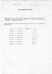
Document, "LRV Braking distances", c1990
... "LRV Braking distances"...Photocopied sheet A4 titled "LRV Braking distances"...Melbourne Tram Museum 8 Wallen Road Hawthorn melbourne Sheet produced to show drivers the length that a LRV (B class) takes to stop at speeds at full service braking from 10kmph to 80kmph - varies from 2.9m to 189.9m Yields information about tram braking distances for LRVs tramways trams brakes Tram Brakes LRV B class Photocopied sheet A4 titled "LRV Braking distances" "LRV Braking distances" Document ...Sheet produced to show drivers the length that a LRV (B class) takes to stop at speeds at full service braking from 10kmph to 80kmph - varies from 2.9m to 189.9mYields information about tram braking distances for LRVsPhotocopied sheet A4 titled "LRV Braking distances"tramways, trams, brakes, tram brakes, lrv, b class -
 Ballarat Tramway Museum
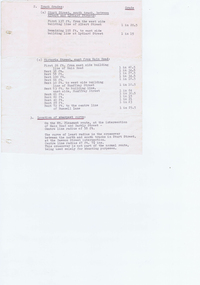
document - Typed Notes, "Track Grades" and "Tramway Route Distances", 1953
... "Track Grades" and "Tramway Route Distances".... - "Tramway Route Distances" detailing the distances in Ballarat over the various routes and within the city, often measured from building lines, provided in chains. ..."Track Grades" and "Tramway Route Distances" document Typed Notes ...Yields information about the curves and grades and track distances in Ballarat on its tramways.Typed notes titled 1. - "Tramway Route Distances" detailing the distances in Ballarat over the various routes and within the city, often measured from building lines, provided in chains. Typed 12/3/1953, initials "WM" 2 - "Track Grades" - for Sturt St, South track between Albert and Lydiard St (south side), North side (between Courier Office and Lydiard St", Victoria St, east from Main Road, location of sharpest curve (Main Road into Barkly St), Dawson St crossover, Contained within Reg Item 5507 - Foolscap binder with green covers, black binding edge and metal clips. track, ballarat -
 Ballarat Tramway Museum
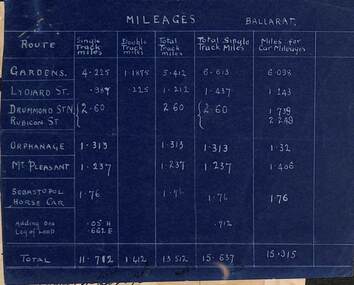
Document - Report, Electric Supply Co. of Vic (ESCo), "Mileages Ballarat", "Fare Distances", c1920?
... "Mileages Ballarat", "Fare Distances"...Provides single track miles, double track miles, Total track, Total Single track miles, miles for car mileages. .2 - "Fares Distances" dated 7-3-01 - all routes. Has been prepared on the rear of a 1921 calendar, Brown, Win? ..."Mileages Ballarat", "Fare Distances" Document Report Electric Supply Co. of Vic (ESCo) ...Yields information about track mileages and horse tram track and information used in calculating fares.Report or chart - set of two documents pinned together in the top left hand corner giving information of system miles for both track and fares. .1 - Blue print - Mileages Ballarat - giving route including Sebastopol Horse car and one leg of a loop. Provides single track miles, double track miles, Total track, Total Single track miles, miles for car mileages. .2 - "Fares Distances" dated 7-3-01 - all routes. Has been prepared on the rear of a 1921 calendar, Brown, Win? of 30 Armstrong St Ballarat.trams, tramways, mileage, horse trams, esco, fares, crossing loop -
 Phillip Island and District Historical Society Inc.
Book, F.E. Hiscocks &? Co, F.E. Hiscocks &? Co.'s new Victorian counties atlas, 1874 [cartographic material] : together with map of Victoria, indicating roads, distances, relative position of counties, &?c, 1874
... s new Victorian counties atlas, 1874 [cartographic material] : together with map of Victoria, indicating roads, distances, relative position of counties, &?c....s new Victorian counties atlas, 1874 [cartographic material] : together with map of Victoria, indicating roads, distances, relative position of counties, &?c. ...Labelled 'Cowes Free Public Library', 'Phillip Island Historical Society, Cleeland Bequest'.victoria, maps -
 Phillip Island and District Historical Society Inc.
Photograph, Early 20th Century
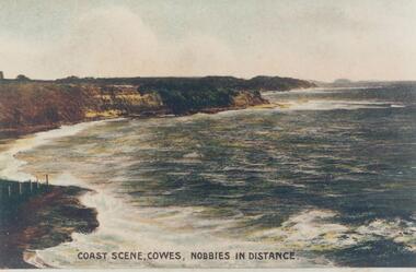
... Coloured copy of a postcard showing the coastal cliffs on Westernport with The Nobbies in the distance..."Coast Scene, Cowes, Nobbies in Distance."...Phillip Island and District Historical Society Inc. phillip-island-and-the-bass-coast One of a collection of photographs donated by Bruce Bennett phillip island coastline cliffs and shoreline westernport bruce bennett "Coast Scene, Cowes, Nobbies in Distance." Coloured copy of a postcard showing the coastal cliffs on Westernport with The Nobbies in the distance Photograph Photograph ...One of a collection of photographs donated by Bruce BennettColoured copy of a postcard showing the coastal cliffs on Westernport with The Nobbies in the distance"Coast Scene, Cowes, Nobbies in Distance."phillip island coastline, cliffs and shoreline westernport, bruce bennett -
 Phillip Island and District Historical Society Inc.
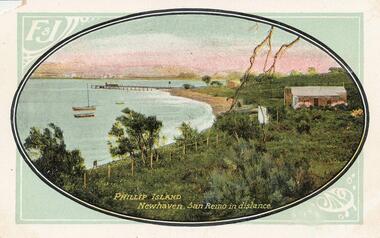
Photograph - Post Card, 1900's
... Coloured Postcard with oval photograph of Newhaven with San Remo in the distance. Two boates moored close to Newhaven beach with Jetty behind. ..."Phillip Island Newhaven, San Remo in distance." 'F & J"...Phillip Island and District Historical Society Inc. phillip-island-and-the-bass-coast Donated by Jean Parle newhaven foreshore phillip island jean parle "Phillip Island Newhaven, San Remo in distance." 'F & J" Coloured Postcard with oval photograph of Newhaven with San Remo in the distance. ...Donated by Jean ParleColoured Postcard with oval photograph of Newhaven with San Remo in the distance. Two boates moored close to Newhaven beach with Jetty behind. Three buildings, a fence and trees."Phillip Island Newhaven, San Remo in distance." 'F & J"newhaven foreshore, phillip island, jean parle -
Glenelg Shire Council Cultural Collection
Photograph - Photograph - Bridgewater Bay, Bridgewater Victoria, n.d
... View from beach across bay, Cape Bridgewater in distance....Back: 'Cape Bridgewater in distance. View of beach' - handwritten, black ink Round purple stamp 'PRINTED BY M.E. ...View from beach across bay, Cape Bridgewater in distance. Photograph Photograph - Bridgewater Bay, Bridgewater Victoria ...Black and white photo. View from beach across bay, Cape Bridgewater in distance.Back: 'Cape Bridgewater in distance. View of beach' - handwritten, black ink Round purple stamp 'PRINTED BY M.E. ANDREWS PORTLAND'bridgewater bay -
Hume City Civic Collection
Print, 1993
... The Rupertswood Mansion is also featured in the distance....A coloured print with a white border of a rural landscape in a valley featuring a bridge in the middle distance and a large building in the distance....Bridges Rupertswood Cutting Rupertswood Railways A.Rafferty 93 A coloured print with a white border of a rural landscape in a valley featuring a bridge in the middle distance and a large building in the distance. ...The coloured print features the railway bridge which spans the Rupertswood Cutting and is north of the Sunbury Railway station. The Rupertswood Mansion is also featured in the distance.A coloured print with a white border of a rural landscape in a valley featuring a bridge in the middle distance and a large building in the distance.A.Rafferty 93bridges, rupertswood cutting, rupertswood, railways -
 National Vietnam Veterans Museum (NVVM)
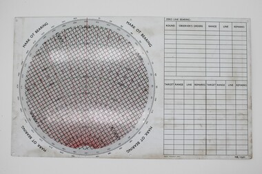
Instrument - Plotting Board, M16
... A scale pivoted at the centre assists in reading distances....East and West in centre distances in black on outer of disc. Distances in green on inner North, South, East, West. ...East and West in centre distances in black on outer of disc. Distances in green on inner North, South, East, West. ...Standard issue item as used by Australian servicemen during the conflict in Vietnam. A plotting board is a mechanical device used as part of a firing control system to track the observed course of a target, project its future position, and derive the azimuth (or direction) and range needed to direct the fire of the guns of a battery to hit that target.White plastic base. A circle marked with grid lines is printed on the base and a vernier for finding azimuth deflections in along top edge. Rotating disc pivots at the centre atop the disc with distances measured radially form 0 at the centre to 3400 metres around the rim range form 0-6400 metres. A scale pivoted at the centre assists in reading distances.Nth and Sth top and bottom on rotating disc. East and West in centre distances in black on outer of disc. Distances in green on inner North, South, East, West. Varn W left bottom of disc. varn E on right bottom of disc.plotting board, m16 -
Whitehorse Historical Society Inc.
Document, Bob Lewis, n.d
... For Long Distance Running....WHS nominated Bob Lewis as a Local Sporting Hero for Long Distance Running....WHS nominated Bob Lewis as a Local Sporting Hero for Long Distance Running. Bob Lewis Document Document ...WHS nominated Bob Lewis as a Local Sporting Hero.WHS nominated Bob Lewis as a Local Sporting Hero for Long Distance Running.WHS nominated Bob Lewis as a Local Sporting Hero.lewis, bob, running, whitehorse historical society inc -
 Stawell Historical Society Inc
Postcard, Track to Mackey's Peak Showing Lake Fyans in Distance in the Grampians -- Postcard
... Track to Mackey's Peak Showing Lake Fyans in Distance in the Grampians -- Postcard...Photographic post card of track to Mackey's Peak showing Lake Fyans in distance "The Grampians"....Post Card Kodak Australia written in pencil on the back "The Track to Mackey's peak showing Lake Fyan's in distance"....Track to Mackey's Peak Showing Lake Fyans in Distance in the Grampians -- Postcard Postcard ...Photographic post card of track to Mackey's Peak showing Lake Fyans in distance "The Grampians".Black and white photograph of a bush scene with mountain views.Post Card Kodak Australia written in pencil on the back "The Track to Mackey's peak showing Lake Fyan's in distance".halls gap grampians -
Hume City Civic Collection
Print, Rupertswood, 1983
... The coloured print features the bridge which spans the Rupertswood Cutting and is north of Sunbury station on the Bendigo line with the Rupertswood Mansion in the middle distance....A large coloured print of a railway bridge spanning a river with a mansion in the distance....Hume City Civic Collection 44 Macedon Street Sunbury melbourne The coloured print features the bridge which spans the Rupertswood Cutting and is north of Sunbury station on the Bendigo line with the Rupertswood Mansion in the middle distance. Rupertswood Mansion Rupertswood Cutting Railways A large coloured print of a railway bridge spanning a river with a mansion in the distance. ...The coloured print features the bridge which spans the Rupertswood Cutting and is north of Sunbury station on the Bendigo line with the Rupertswood Mansion in the middle distance.A large coloured print of a railway bridge spanning a river with a mansion in the distance.rupertswood mansion, rupertswood cutting, railways -
 Department of Energy, Environment and Climate Action
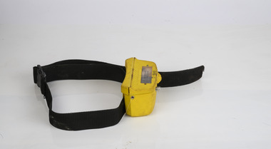
HipChain Distance Measurer
... Hipchains are a reliable tool for precise long distance measurement, particularly with irregular boundaries, in rough terrain or thick scrub To use, simply tie the cotton thread to a fixed object at your starting point, zero the counter, and start walking. ...HipChain Distance Measurer...Forest measurement Surveying HipChain Distance Measurer HipChain Distance Measurer ...Hipchains are a reliable tool for precise long distance measurement, particularly with irregular boundaries, in rough terrain or thick scrub To use, simply tie the cotton thread to a fixed object at your starting point, zero the counter, and start walking. As you move, the thread extends, turning the counter. The instrument attaches to your belt, keeping the thread taut and accurate. Once you reach your endpoint, break the thread and continue.HipChain Distance Measurerforest measurement, surveying -
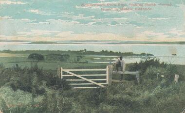 Phillip Island and District Historical Society Inc.
Photograph - Post Card, Early 1900's
... French Island in the distance. Man standing on fence beside gate...."Westernport from Rhyll, looking North, French Island in Middle Distance." "Robb Bros. Cowes" On back a letter from M Evans of Ventnor to ?? ...French Island in the distance. Man standing on fence beside gate. ...One of a collection of photographs donated by Shirley Peterson.Colour postcard of farmland in foreground looking across Westernport from Rhyll. French Island in the distance. Man standing on fence beside gate."Westernport from Rhyll, looking North, French Island in Middle Distance." "Robb Bros. Cowes" On back a letter from M Evans of Ventnor to ?? in Ascot Vale.rhyll farmland phillip island, westernport bay, phillip island, shirley peterson -
Whitehorse Historical Society Inc.
Document, Dot Browne OAM, n.d
... For Long Distance Running and her contribution to Athletics with photographs....WHS nominated Dot Browne OAM as a Local Sporting Hero for Long Distance Running and her contribution to Athletics with photographs....Whitehorse Historical Society Inc. 2-10 Deep Creek Road Mitcham melbourne For Long Distance Running and her contribution to Athletics with photographs. ...WHS nominated Dot Browne OAM as a Local Sporting Hero.WHS nominated Dot Browne OAM as a Local Sporting Hero for Long Distance Running and her contribution to Athletics with photographs.WHS nominated Dot Browne OAM as a Local Sporting Hero.browne, dot, athletics, whitehorse historical society inc, running -
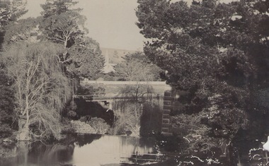 Sunbury Family History and Heritage Society Inc.
Photograph, c 1910
... The tower of the Rupertswood Mansion can be seen in the distance. The Eadie family were business people and millers in Sunbury....A post card featuring a dark sepia image of a creek with a large house in the distance. There is a hand written message on the back....A post card featuring a dark sepia image of a creek with a large house in the distance. There is a hand written message on the back. ...The photograph was taken from the iron bridge on the Rupertswood Estate. The tower of the Rupertswood Mansion can be seen in the distance. The Eadie family were business people and millers in Sunbury.A post card featuring a dark sepia image of a creek with a large house in the distance. There is a hand written message on the back.Written on the back: Dear old boy Many happy returns of the 8th. I . . . . . . . . . . . . making the . . . .Yours ever Will. Iron bridge at Rupertswood. Mr Hal Eadie Dannevirke NZ.rupertswood mansion, jacksons creek -
 Sunbury Family History and Heritage Society Inc.
Photograph, Marilyn Bray, October 1984
... Mary's Church Hall is the small building in the distance....A red-bricked building with white trim as well as a cream building is in the middle distance and a smaller brick building is in the distance....A red-bricked building with white trim as well as a cream building is in the middle distance and a smaller brick building is in the distance. ...The parkland is part of the Village Green, which is surrounded by Barkly, Brook and Macedon Streets in Sunbury. In the foreground is the temperature controlled glass building which houses the restored Armstrong twelve pounder gun that the Clarke family gifted to the people of Sunbury in 1922. For many years it stood in the open at the junction of Macedon, Stawell and Barkly Streets until 1970. The Starkie Water Fountain is on the LHS of the image. The cream building in the middle distance is the Memorial Hall, formerly the Mechanics Institute, built in 1885 and the red brick building is the former Sunbury State School. St. Mary's Church Hall is the small building in the distance.In 1973 Shire of Bulla council closed off Stawell Street to create the Village Green for a passive recreation area, which also included a section for the placing of important memorials. The green space has become a popular recreation area close to the town centre for Sunbury residents.A non-digital coloured photograph of parkland with lawn and elm trees, interspersed with four buildings. A glassed in structure with a hipped roof is in the foreground. A red-bricked building with white trim as well as a cream building is in the middle distance and a smaller brick building is in the distance.sunbury gun, stawell street, memorial hall, j.d.starkie memorial, barkly street, macedon street, sunbury village green -
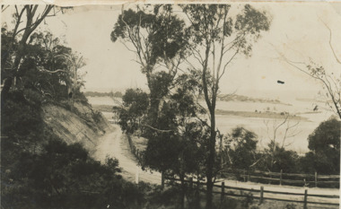 Lakes Entrance Historical Society
Postcard - Princes Highway around Jemmy's Point
... Bullock Island and the entrance in the distance c1925...Bullock Island and the entrance in the distance...Bullock Island and the entrance in the distance Princes Highway around Jemmy's Point Postcard Princes Highway around Jemmy's Point ...Princes Highway around Jemmy's Point . Unsealed road and post and rail fence. Bullock Island and the entrance in the distance c1925Black and white photograph of Princes Highway around Jemmy's Point . Unsealed road and post and rail fence. Bullock Island and the entrance in the distance waterways, topography, islands, roads and streets -
 Mt Dandenong & District Historical Society Inc.
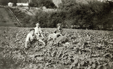
Photograph, Pickers picnicking in a crop on Hillside c1920, c1920
... Two men, a woman and a dog sitting in a crop with Mountjoy Guest-house in the distance....Two buildinga and other crops can be seen in the distance....Two buildinga and other crops can be seen in the distance. Pickers picnicking in a crop on Hillside c1920. ...Two men, a woman and a dog sitting in a crop with Mountjoy Guest-house in the distance. Black and white photograph of two young men and a woman holding a dog sitting down in a crop field. Two buildinga and other crops can be seen in the distance.guest house, mountjoy -
 Greensborough Historical Society
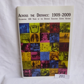
Book, Distance Education Centre Victoria, Across the distance: 1909-2009. Celebrating 100 years of the Distance Education Centre Victoria, 1909-2009
... Across the distance: 1909-2009. Celebrating 100 years of the Distance Education Centre Victoria...A brief history of the Distance Education Centre Victoria, previously the Victorian Correspondence School. ...Front cover has a collage illustrating distance education work over 100 years....Distance Education Centre Victoria...Front cover has a collage illustrating distance education work over 100 years. Across the distance: 1909-2009. ...A brief history of the Distance Education Centre Victoria, previously the Victorian Correspondence School. Contains selected examples of students and their work.Soft cover. 97 pages, illus (some colour). Front cover has a collage illustrating distance education work over 100 years.distance education centre victoria, jenny campbell, victorian correspondence school -
 Lakes Entrance Historical Society
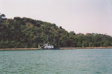
Photograph - Dredge on Gippsland Lakes, M Holding, 2008 c
... Glimpse of houses on Kalimna Heights in distance Lakes Entrance Victoria...Glimpse of houses on Kalimna Heights in distance Lakes Entrance Victoria...Glimpse of houses on Kalimna Heights in distance Lakes Entrance Victoria Dredge on Gippsland Lakes Photograph Dredge on Gippsland Lakes M Holding ...dredge working on edge of lake below Jemmys Point. Glimpse of houses on Kalimna Heights in distance Lakes Entrance VictoriaColour photograph showing dredge working on edge of lake below Jemmys Point. Glimpse of houses on Kalimna Heights in distance Lakes Entrance Victoria waterways, topography, dredges -
 Lakes Entrance Historical Society
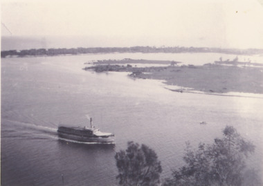
Photograph - SS Gippsland on Gippsland Lakes, 1927
... postcard taken from Jemmys Point with SS Gippsland in the Narrows passing Rigby Island, Snake Island and outer barrier in distance...Black and white copy of postcard taken from Jemmys Point with SS Gippsland in the Narrows passing Rigby Island, Snake Island and outer barrier in distance...Lakes Entrance Historical Society 4 Marine Parade Lakes Entrance gippsland postcard taken from Jemmys Point with SS Gippsland in the Narrows passing Rigby Island, Snake Island and outer barrier in distance Vegetation Waterfront Gippsland Lakes Topography Boats and Boating Black and white copy of postcard taken from Jemmys Point with SS Gippsland in the Narrows passing Rigby Island, Snake Island and outer barrier in distance SS Gippsland on Gippsland Lakes Photograph SS Gippsland on Gippsland Lakes ...postcard taken from Jemmys Point with SS Gippsland in the Narrows passing Rigby Island, Snake Island and outer barrier in distanceBlack and white copy of postcard taken from Jemmys Point with SS Gippsland in the Narrows passing Rigby Island, Snake Island and outer barrier in distancevegetation, waterfront, gippsland lakes, topography, boats and boating -
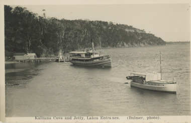
 Lakes Entrance Historical Society
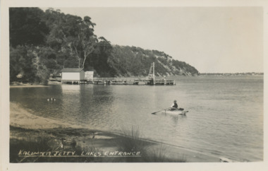
Postcard - Kalimna Jetty Lakes Entrance Victoria, H D Bulmer, 1930 c
... Kalimna Jetty showing two sheds on jetty man rowing boat on lake Jemmys Point in distance Lakes Entrance Victoria...Black and white postcard of Kalimna Jetty showing two sheds on jetty man rowing boat on lake Jemmys Point in distance Lakes Entrance Victoria...Lakes Entrance Historical Society 4 Marine Parade Lakes Entrance gippsland Kalimna Jetty showing two sheds on jetty man rowing boat on lake Jemmys Point in distance Lakes Entrance Victoria Jetties Waterways Boats and Boating Kalimna Jetty Lakes Entrance Black and white postcard of Kalimna Jetty showing two sheds on jetty man rowing boat on lake Jemmys Point in distance Lakes Entrance Victoria Postcard Kalimna Jetty Lakes Entrance Victoria H D Bulmer ...Kalimna Jetty showing two sheds on jetty man rowing boat on lake Jemmys Point in distance Lakes Entrance VictoriaBlack and white postcard of Kalimna Jetty showing two sheds on jetty man rowing boat on lake Jemmys Point in distance Lakes Entrance VictoriaKalimna Jetty Lakes Entrancejetties, waterways, boats and boating -
 Clunes Museum
Photograph, BAWDEN PHOTOGRAPHER, CIRCA 1890
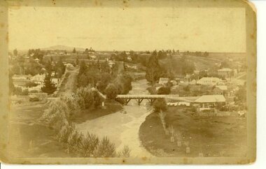
... ABOUT 1890 - NOTE GOVERNMENT BRIDGE IN DISTANCE. THIS WAS REBUILT IN STRAIGHT STEEL GIRDERS IN 1896....TWO MILE HILL IN LEFT FAR DISTANCE. (SUSPENSION BRIDGE IN FOREGROUND)...TWO MILE HILL IN LEFT FAR DISTANCE. (SUSPENSION BRIDGE IN FOREGROUND) Photograph PHOTOGRAPH BAWDEN PHOTOGRAPHER ...TULLAROOP CREEK FROM "ROCKS" NEAR SITE OF PORT PHILLIP MINE. ABOUT 1890 - NOTE GOVERNMENT BRIDGE IN DISTANCE. THIS WAS REBUILT IN STRAIGHT STEEL GIRDERS IN 1896.ORIGINAL SEPIA PHOTOGRAPH OF TULLAROOP CREEK, IN FOREGROUND VIEWS OF CLUNES TOWNSHIP. TWO MILE HILL IN LEFT FAR DISTANCE. (SUSPENSION BRIDGE IN FOREGROUND)local history, photography, bridges - buildings and landscape of clunes -
 Sunbury Family History and Heritage Society Inc.
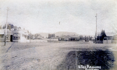
Postcard, To the Railway/Sunbury
... Mount Holden is in the distance. Chris Christianson's shop is on the LHS of the picture with the post office on the RHS. ...A non-digital sepia photograph in post card format of a view of a town centre showing an intersection and some small buildings with a hill in the distance....Mount Holden is in the distance. Chris Christianson's shop is on the LHS of the picture with the post office on the RHS. ...The post card is an early view of the intersection of Brook and Evans Street looking west and towards Sunbury Station. Mount Holden is in the distance. Chris Christianson's shop is on the LHS of the picture with the post office on the RHS. This image is an early view of Sunbury town centre with the railway station and post office. Like many country towns of this era, The roads have been formed but not surfaced. A non-digital sepia photograph in post card format of a view of a town centre showing an intersection and some small buildings with a hill in the distance.TO THE RAILWAY/SUNBURYbrook street, evans street, sunbury railway station, christianson, chris. -
 Victorian Harness Racing Heritage Collection at Lord's Raceway Bendigo
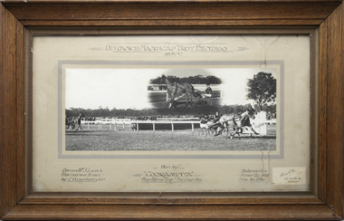
Photograph - Wooden framed photo finish, Akers & Co, Cooraminta, 26 August 1937
... Cooraminta won the Distance Handicap Trot Bendigo on the 26 August 1937, followed by Phar Patrol and The Gap. ...At the top: Distance Handicap Trot Bendigo / 26-8-37 At the bottom: Left corner: Owner Mr J Lewis / Trained and Driven by C Robertson Jun Centre: Won by Cooraminta / Phar Patrol 2nd / The Gap 3rd Right corner: Distance 1 1/4m / H'Cap 12 y bnd / Time 3m 0 3/4s / Akers & Co, 486 Bourke St Melbourne...Victorian Harness Racing Heritage Collection at Lord's Raceway Bendigo Lords Raceway, McIvor Highway Junortoun goldfields Cooraminta won the Distance Handicap Trot Bendigo on the 26 August 1937, followed by Phar Patrol and The Gap. ...Cooraminta won the Distance Handicap Trot Bendigo on the 26 August 1937, followed by Phar Patrol and The Gap. Cooraminta owned by Mr J Lewis, was trained and driven by C Robertson Jun. Two colour photographs, one small one large in a brown frame. At the top: Distance Handicap Trot Bendigo / 26-8-37 At the bottom: Left corner: Owner Mr J Lewis / Trained and Driven by C Robertson Jun Centre: Won by Cooraminta / Phar Patrol 2nd / The Gap 3rd Right corner: Distance 1 1/4m / H'Cap 12 y bnd / Time 3m 0 3/4s / Akers & Co, 486 Bourke St Melbournehorses, race, winner, bendigo trotting club, driver, trainer, owner, bendigo, 1937, cooraminta, mr j lewis, phar patrol, the gap, charlie robertson jnr, c robertson jnr, charlie robertson, c robertson -
 Lakes Entrance Historical Society
Postcard - S S Gippsland leaving Kalimna Jetty Lakes Entrance, H D Bulmer, 1930 c
... S S Gippsland leaving Kalimna Jetty Holdens boat Sagitasse moored nearby Jemmys Point in distance Lakes Entrance Victoria...Black and white postcard showing S S Gippsland leaving Kalimna Jetty Holdens boat Sagitasse moored nearby Jemmys Point in distance Lakes Entrance Victoria...Lakes Entrance Historical Society 4 Marine Parade Lakes Entrance gippsland S S Gippsland leaving Kalimna Jetty Holdens boat Sagitasse moored nearby Jemmys Point in distance Lakes Entrance Victoria Islands Waterways Boats and Boating Tourism Kalimna Cove and Jetty Lakes Entrance Black and white postcard showing S S Gippsland leaving Kalimna Jetty Holdens boat Sagitasse moored nearby Jemmys Point in distance Lakes Entrance Victoria S S Gippsland leaving Kalimna Jetty Lakes Entrance Postcard S S Gippsland leaving Kalimna Jetty Lakes Entrance H D Bulmer ...S S Gippsland leaving Kalimna Jetty Holdens boat Sagitasse moored nearby Jemmys Point in distance Lakes Entrance VictoriaBlack and white postcard showing S S Gippsland leaving Kalimna Jetty Holdens boat Sagitasse moored nearby Jemmys Point in distance Lakes Entrance VictoriaKalimna Cove and Jetty Lakes Entranceislands, waterways, boats and boating, tourism -
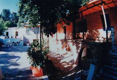 Ithacan Historical Society
Photograph, Panagias Monastery, Ithaca, Late
... The photograph is showing the newer brick section ofthe Monastery of Panagia Kathariotssa following renovations, and the older white rendered section which is in the middle distance of the image. ...An older section of the building is adjacent to the terrace in the middle distance of the photograph. There are potted plants placed around the courtyard. ...An older section of the building is adjacent to the terrace in the middle distance of the photograph. There are potted plants placed around the courtyard. ...The photograph is showing the newer brick section ofthe Monastery of Panagia Kathariotssa following renovations, and the older white rendered section which is in the middle distance of the image. A coloured photograph of a brick building and a shaded courtyard with potted plants. An older section of the building is adjacent to the terrace in the middle distance of the photograph. There are potted plants placed around the courtyard. -
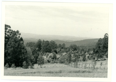 Mt Dandenong & District Historical Society Inc.
Photograph
... Black and white photograph showing a cleared area in the foreground with young tress in the centre and hills in the distance. Several rooftops can be seen mid photo on the right. ...The Falls gully is in the middle distance. Peter Damman's fence running downhill right foreground....The Falls gully is in the middle distance. Peter Damman's fence running downhill right foreground. ...In 1913 Edgar Dower took a photograph from this spot on Ridge Road that became known as Point Clear showing the Mt Dandenong township behind a stand of tall, dead trees. John Lundy-Clarke took this photograph from a similar spot at the Mt Dandenong Arboretum in 1975.Black and white photograph showing a cleared area in the foreground with young tress in the centre and hills in the distance. Several rooftops can be seen mid photo on the right. Reverse of photograph has handwritten description by John Lundy-Clarke.1975 View from the Arboretum over Mt D'nong township at the spot where Edgar Dower took the 1913 photo. The Falls gully is in the middle distance. Peter Damman's fence running downhill right foreground.edgar dower, point clear, mt dandenong, john lundy-clarke, peter damman, arboretum -
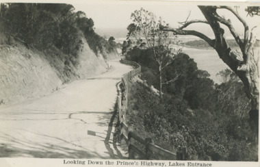 Lakes Entrance Historical Society
Postcard - Princes Highway Lakes Entrance, 1930 c
... Princes Highway Jemmys Point showing gravel road post and rail fence freshly excavated cliff with Entrance glimpses in distance Lakes Entrance Victoria. Also a second black and white postcard taken much later of Princes Highway Jemmys Point Lakes Entrance showing sealed road with double lines in centre, post and rail fence, Entrance in distance. ...Black and white postcard taken of Princes Highway Jemmys Point showing gravel road post and rail fence freshly excavated cliff with Entrance glimpses in distance Lakes Entrance Victoria...Lakes Entrance Historical Society 4 Marine Parade Lakes Entrance gippsland Princes Highway Jemmys Point showing gravel road post and rail fence freshly excavated cliff with Entrance glimpses in distance Lakes Entrance Victoria. Also a second black and white postcard taken much later of Princes Highway Jemmys Point Lakes Entrance showing sealed road with double lines in centre, post and rail fence, Entrance in distance. ...Princes Highway Jemmys Point showing gravel road post and rail fence freshly excavated cliff with Entrance glimpses in distance Lakes Entrance Victoria. Also a second black and white postcard taken much later of Princes Highway Jemmys Point Lakes Entrance showing sealed road with double lines in centre, post and rail fence, Entrance in distance. Donor Susan Samuel 2 January 2015. Number 04204.1Black and white postcard taken of Princes Highway Jemmys Point showing gravel road post and rail fence freshly excavated cliff with Entrance glimpses in distance Lakes Entrance VictoriaLooking Down the Princes Highway Lakes Entrancecivil engineering, roads and streets, fences