Bendigo Historical Society Inc.
Document - DRAINAGE PROBLEMS - DRAINAGE 1905 - 1908
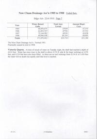
... DRAINAGE PROBLEMS - DRAINAGE 1905 - 1908...... Drainage 1905 - 1908...1908. Mines mentioned are: New Chum Railway, Eureka Ext'd, New Chum Con'd, Lazarus, Garibaldi, Lansells 180, Victoria Quartz, Lansell's 222, New Chum & Vic., Shamrock and New Shenandoah. Note along the side: re - Vict Quartz Inrush Water. Adv. Wed. 22/6/1910. (b) Handwritten notes on the New Chum Drainage Ass'n 1905...History House 11 Mackenzie Street Bendigo goldfields DOCUMENT Gold drainage problems New Chum Drainage Association Drainage 1905 - 1908 Bendigo Advertiser 22/6/1910 Victoria Quartz New Chum Railway Eureka Ext'd New Chum Con'd Lazarus Garibaldi Lansell's 180 Lansell's 222. ...
Handwritten notes from the Bendigo Advertiser 22/6/1910, listing the mine, Gallons baled, Deepest depth baled from, Total amount Rec'd, ? ? Coy for Financial Year ended 30/6/1908. Mines mentioned are: New Chum Railway, Eureka Ext'd, New Chum Con'd, Lazarus, Garibaldi, Lansells 180, Victoria Quartz, Lansell's 222, New Chum & Vic., Shamrock and New Shenandoah. Note along the side: re - Vict Quartz Inrush Water. Adv. Wed. 22/6/1910. (b) Handwritten notes on the New Chum Drainage Ass'n 1905 - 1908 from the Bendigo Advertiser 22/6/1910. Listed is the Year, Water Raised (Gallons), Total Amount Re?ed and Amount Re? Coys. The New Chum Drainage Ass'n was formed in 1901 and practically ceased to exist in 1908. Victoria Quartz at time of inrush of water on Tuesday night, the shaft had reached a depth of 4,614 feet. Water has since risen in the shaft to above 4,154 ft plat & the large workings at 4,254 feet, and 4,154 feet have also been t filled. As there are no reef workings from 4,154 to 3,424 feet the water will no doubt rise rapidly until that level is reached. Document from Albert Richardson Collection of mining history.document, gold, drainage problems, new chum drainage association, drainage 1905 - 1908, bendigo advertiser 22/6/1910, victoria quartz, new chum railway, eureka ext'd, new chum con'd, lazarus, garibaldi, lansell's 180, lansell's 222. mew chum & vic, shamrock, new shenandoah
 Bendigo Historical Society Inc.
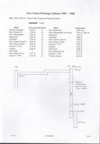 Bendigo Historical Society Inc.