Showing 11407 items matching " england"
-
 Ballarat Heritage Services
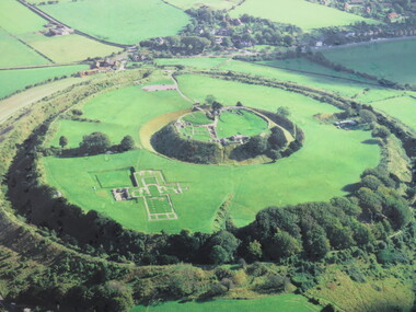
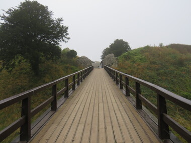
Photograph - Photograph - Colour, Old Sarum, England, 2016, 01/11/2016
... Old Sarum, England, 2016......england...William the Conqueror inherited Old Sarum from the last Saxon king of England. It was an ideal site for a royal castle. ...Colour photograph of Old Sarum, England....Old Sarum, England...It was here in 1070 that William paid off his army after a long and bitter campaign in northern England. It was here in 1086 that he called together all the major landholders in England so they could swear allegiance to him. ...William the Conqueror inherited Old Sarum from the last Saxon king of England. It was an ideal site for a royal castle. It was here in 1070 that William paid off his army after a long and bitter campaign in northern England. It was here in 1086 that he called together all the major landholders in England so they could swear allegiance to him. It was a crucial moment. The Domesday Book was being written, a threatened Viking invasion had only just been averted and William's eldest son was in armed rebellion. Old Sarum was an important place where this Norman king of England held power. In 1794 the Ordnance Survey set out to check the accuracy of the first mapping of Southern England, which had begun ten years earlier. From a point just below Old Sarum Lieutenant William Mudge laid out a base-line 36,574 feet (11,253 metres) long. From each end of the line the positions of distant places were plotted using a huge theodolite made in 1791 by Jesse Ramsden. The accuracy of the process, which was repeated all over England, depended on Jesse Ramsden's craftsmanship and on William Mudge's surveying skill in setting out this first base-line from Old Sarum. The nearer end of Mudge's line is marked by an inscribed stone beside the modern A345 at Old Sarum. Colour photograph of Old Sarum, England.ordnance survey, william mudge, jesse ramsden, william the conqueror, old sarum, saxon, 1086, england -
 Ballarat Heritage Services
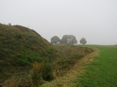
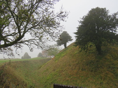
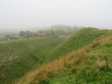
Photograph - Photograph - Colour, Earth Banks, Old Sarum, England, 01 November 2016
... Earth Banks, Old Sarum, England......england...William the Conqueror inherited Old Sarum from the last Saxon king of England. It was an ideal site for a royal castle. ...Colour photograph of Earth Banks, Old Sarum, England...Old Sarum, England...It was here in 1070 that William paid off his army after a long and bitter campaign in northern England. It was here in 1086 that he called together all the major landholders in England so they could swear allegiance to him. ...William the Conqueror inherited Old Sarum from the last Saxon king of England. It was an ideal site for a royal castle. It was here in 1070 that William paid off his army after a long and bitter campaign in northern England. It was here in 1086 that he called together all the major landholders in England so they could swear allegiance to him. It was a crucial moment. The Domesday Book was being written, a threatened Viking invasion had only just been averted and William's eldest son was in armed rebellion. Old Sarum was an important place where this Norman king of England held power. In 1794 the Ordnance Survey set out to check the accuracy of the first mapping of Southern England, which had begun ten years earlier. From a point just below Old Sarum Lieutenant William Mudge laid out a base-line 36,574 feet (11,253 metres) long. From each end of the line the positions of distant places were plotted using a huge theodolite made in 1791 by Jesse Ramsden. The accuracy of the process, which was repeated all over England, depended on Jesse Ramsden's craftsmanship and on William Mudge's surveying skill in setting out this first base-line from Old Sarum. The nearer end of Mudge's line is marked by an inscribed stone beside the modern A345 at Old Sarum. Colour photograph of Earth Banks, Old Sarum, Englandordnance survey, william mudge, jesse ramsden, william the conqueror, old sarum, saxon, 1086, england -
 Greensborough Historical Society
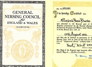
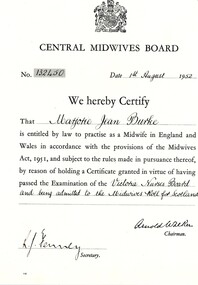
Document - Certificate, Central Midwives Board (England and Wales) et al, Certificate to practise as a registered nurse (England) for Marjorie Jean Burke, 29/08/1952
... Certificate to practise as a registered nurse (England) for Marjorie Jean Burke...Certificate to practise as a registered nurse in England and Wales for Marjorie Jean Burke, from the General Nursing Council for England and Wales, issued in 1952....Central Midwives Board (England and Wales)...Greensborough Historical Society 34A Glenauburn Road Lower Plenty Lower Plenty melbourne Certificate to practise as a registered nurse in England and Wales for Marjorie Jean Burke, from the General Nursing Council for England and Wales, issued in 1952. ...Certificate to practise as a registered nurse in England and Wales for Marjorie Jean Burke, from the General Nursing Council for England and Wales, issued in 1952.Miss Burke was a nurse, midwife and infant welfare sister. This collection covers her many qualifications throughout Australia and Great Britain, including references both professional and personal. When Miss Burke returned to Australia, she was employed at Diamond Valley Community Hospital as a nurse in 1953 and as Deputy Matron 1954-1971.Certificate on cream folded paper.Signed by Registrar.marjorie jean burke, nurses, diamond valley community hospital, central midwives board for england and wales, general nursing council for england and wales -
 Ballarat Heritage Services
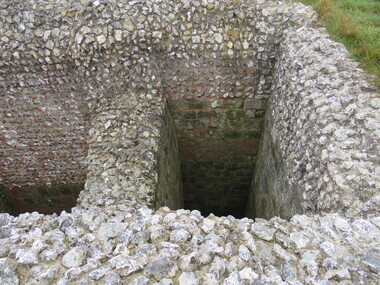
Photograph - Photograph - Colour, Castle toilets, Old Sarum, England, 2016, 01/11/2016
... Castle toilets, Old Sarum, England, 2016......england...William the Conqueror inherited Old Sarum from the last Saxon king of England. It was an ideal site for a royal castle. ...Colour photographs of Castle toilets at Old Sarum, England. The toilets are constructed of stone. ...Old Sarum, England...It was here in 1070 that William paid off his army after a long and bitter campaign in northern England. It was here in 1086 that he called together all the major landholders in England so they could swear allegiance to him. ...William the Conqueror inherited Old Sarum from the last Saxon king of England. It was an ideal site for a royal castle. It was here in 1070 that William paid off his army after a long and bitter campaign in northern England. It was here in 1086 that he called together all the major landholders in England so they could swear allegiance to him. It was a crucial moment. The Domesday Book was being written, a threatened Viking invasion had only just been averted and William's eldest son was in armed rebellion. Old Sarum was an important place where this Norman king of England held power. In 1794 the Ordnance Survey set out to check the accuracy of the first mapping of Southern England, which had begun ten years earlier. From a point just below Old Sarum Lieutenant William Mudge laid out a base-line 36,574 feet (11,253 metres) long. From each end of the line the positions of distant places were plotted using a huge theodolite made in 1791 by Jesse Ramsden. The accuracy of the process, which was repeated all over England, depended on Jesse Ramsden's craftsmanship and on William Mudge's surveying skill in setting out this first base-line from Old Sarum. The nearer end of Mudge's line is marked by an inscribed stone beside the modern A345 at Old Sarum. Colour photographs of Castle toilets at Old Sarum, England. The toilets are constructed of stone. ordnance survey, william mudge, jesse ramsden, william the conqueror, old sarum, saxon, 1086, england, subjects, toilets -
 Glenelg Shire Council Cultural Collection
Leisure object - Jigsaw Puzzle and Cardboard box, Old England, n.d
... Old England...a) Wooden jigsaw puzzle titled 'Old England'. Image of cottage garden, lady in chair, knitting. b) Cardboard box containing a). ...PHILMAR. MADE IN ENGLAND...MADE IN ENGLAND Printed in Great Britain ...a) Wooden jigsaw puzzle titled 'Old England'. Image of cottage garden, lady in chair, knitting. b) Cardboard box containing a). Red sides, same image as jigsaw on front of box -
 Greensborough Historical Society
Document - Certificate, Central Midwives Board (England and Wales), Certificate to practise as a midwife (England) for Marjorie Jean Burke, 01/08/1952
... Certificate to practise as a midwife (England) for Marjorie Jean Burke...Certificate to practise as a midwife in England and Wales for Marjorie Jean Burke, from the Central Midwives Board (England), issued in 1952....Central Midwives Board (England and Wales)...Greensborough Historical Society 34A Glenauburn Road Lower Plenty Lower Plenty melbourne Certificate to practise as a midwife in England and Wales for Marjorie Jean Burke, from the Central Midwives Board (England), issued in 1952. ...Certificate to practise as a midwife in England and Wales for Marjorie Jean Burke, from the Central Midwives Board (England), issued in 1952.Miss Burke was a nurse, midwife and infant welfare sister. This collection covers her many qualifications throughout Australia and Great Britain, including references both professional and personal. When Miss Burke returned to Australia, she was employed at Diamond Valley Community Hospital as a nurse in 1953 and as Deputy Matron 1954-1971.Certificate on cream paper.Signed by Chairman and Secretary.marjorie jean burke, nurses, diamond valley community hospital, central midwives board for england and wales -
 Ballarat Heritage Services
Photograph - Photograph - Colour, Cutty Sark vessel and exhibition, Greenwich, England, 06/11/2016
... Cutty Sark vessel and exhibition, Greenwich, England......England...Every year until 1895 she set out in the summer for Australia, to load a cargo of wool bales and return to England in time for the wool sales ini the first three months of the new year. ...Colour photograph of the Cutty Sark at Greenwich, England. ...England...Cutty Sark vessel and exhibition, Greenwich, England Photograph Photograph - Colour ...The Cutty Sark was launched on 22 November 1869. She was named by the wife of George Moodie, the ship's first master who had also supervised her construction. Cutty Sark left the Clyde on 13 January 1870. A month and two days later, she set sail from London for China. Cutty sark was designed and built by Scott & Linton of Dumbarton for 16,150 pounds. But much of the money was to be paid by Willis when the ship was launched. Just before they finished her, Scott & Linton ran out of money and went bankrupt. She was completed by William Denny & Brothers. The Cutty Sark was the first ship to reach London with a tea cargo in 1877. But she was one of only nine sailing ships that returned that year - in 1870 there had been 59. Steamships were now dominating the tea trade. In 1883 the Cutty Sark joined the booming trade in transporting Australian wool. Every year until 1895 she set out in the summer for Australia, to load a cargo of wool bales and return to England in time for the wool sales ini the first three months of the new year. Cutty Sark soon established herself as the fastest of the wool clippers. Under her last master, Richard Woodget she set record times of 70 days or less for the voyage which no other sailing ships could match.Colour photograph of the Cutty Sark at Greenwich, England. cutty sark vessel and exhibition, greenwich, england, dumbartion, william denny, tea, immigration, trade, scott and linton, ship, vessel, boat, sailing ship -
 Greensborough Historical Society
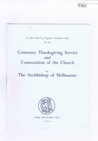
Memorabilia - Booklet, St Johns Church of England, Diamond Creek, Centenary Thanksgiving Service and Consecration of the Church by The Archbishop of Melbourne. St John's Church of England Diamond Creekb1867-1867, 1967
... St John's Church of England Diamond Creekb1867-1867...Order of Service for the Centenary thanksgiving service and consecration of St John's Church of England Diamond Creek by the Archbishop of Melbourne 1967. ...St Johns Church of England, Diamond Creek...St John's Church of England Diamond Creekb1867-1867 Memorabilia Booklet St Johns Church of England, Diamond Creek ...Order of Service for the Centenary thanksgiving service and consecration of St John's Church of England Diamond Creek by the Archbishop of Melbourne 1967. This function was attended by the Morgans.Bruce Morgan was the first Shire Secretary (1964-1983) of the Shire of Diamond Valley. This collection was compiled by his wife, Mavis Morgan, detailing the events they attended in their official capacityBooklet, off white with blue textbruce morgan, mavis morgan, shire of diamond valley, st johns -
 Whitehorse Historical Society Inc.
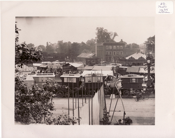
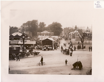
Photograph, Mitcham, Surrey England, 1900
... Mitcham, Surrey England......england...Francis, London House, Mitcham, England. 1900. The photo overlaps and give a panorama of the Fair as far as could been seen from Ravensbury House (J.D.Drewett). ...Mitcham, England....See NP1438 Mitcham, Surrey England Photograph Photograph ...Black and white photo of Mitcham Fair on Fair Green by Thos. Francis, London House, Mitcham, England. 1900. The photo overlaps and give a panorama of the Fair as far as could been seen from Ravensbury House (J.D.Drewett). See NP1438mitcham, england -
 National Vietnam Veterans Museum (NVVM)
Booklet, Sailors' and Soldiers' Church of England Help Society, On Service: A Prayer Book: Issued and Presented by The Sailors' And Soldiers' Church of England Help Society, Brisbane
... On Service: A Prayer Book: Issued and Presented by The Sailors' And Soldiers' Church of England Help Society, Brisbane...On the inside cover is the insignia of the Sailors & Soldiers' Church Of England Help Society and under this reads: Teach us, good Lord, to serve Thee more faithfully; to give and not to count the cost; to fight and not heed the wounds; to toil and not look for rest; to labour and not to ask for any reward, save that of knowing, we try to do Thy will, for the sake of Jesus Christ our Lord. ...Sailors' and Soldiers' Church of England Help Society...On Service: A Prayer Book: Issued and Presented by The Sailors' And Soldiers' Church of England Help Society, Brisbane Booklet Sailors' and Soldiers' Church of England Help Society ...A greyish coloured cardboard cover with black information on the front. There is an oblong section with the word On Service and a cross under this. The booklet is held together with two metal staples down the spine.On the inside cover is the insignia of the Sailors & Soldiers' Church Of England Help Society and under this reads: Teach us, good Lord, to serve Thee more faithfully; to give and not to count the cost; to fight and not heed the wounds; to toil and not look for rest; to labour and not to ask for any reward, save that of knowing, we try to do Thy will, for the sake of Jesus Christ our Lord. Amen.booklet, prayer book, the sailors' and soldiers' church of england help society -
 Stawell Historical Society Inc
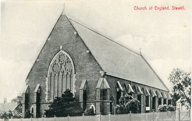
Postcard, Church of England in Main Street Stawell c1907. Two photo's
... Church of England in Main Street Stawell c1907. Two photo's. ...Front of Church of England with wooden picket fence. Red writing Church of England Stawell on top right on one copy Church of England Stawell printed on bottom of second copy but same photo...Church of England Stawell...Stawell Historical Society Inc 46 Longfield St Stawell grampians Second copy donated 9/5/2024 by Meryl Bowers stawell Church of England Stawell Front of Church of England with wooden picket fence. ...Second copy donated 9/5/2024 by Meryl BowersFront of Church of England with wooden picket fence. Red writing Church of England Stawell on top right on one copy Church of England Stawell printed on bottom of second copy but same photoChurch of England Stawellstawell -
 Whitehorse Historical Society Inc.
Photograph, Mitcham, England, 1900
... Mitcham, England......england...Francis, London House, Mitcham, England. 1900. The photo overlaps and give a panorama of the Fair as far as could been seen from Ravensbury House (J.D.Drewett). ...Mitcham, England....See NP1437 Mitcham, England Photograph Photograph ...Black and white photo of Black and white photo of Mitcham Fair on Fair Green by Thos. Francis, London House, Mitcham, England. 1900. The photo overlaps and give a panorama of the Fair as far as could been seen from Ravensbury House (J.D.Drewett). See NP1437mitcham, surrey, england -
 Wodonga & District Historical Society Inc
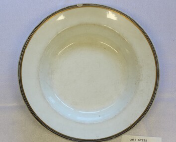
Domestic object - Shallow Vegetable Serving bowl, Johnson Brothers England, 1913 - 1942
... Johnson Bros. was founded by two brothers named Alfred and Frederick who purchased a pottery factory in Hanley, England, in 1883. They were grandsons of a renowned English potter, Alfred Meakin. ...The underside of the bowl bears the mark of Johnson Bros England. The mark is composed of a green crown above the words "Johnson Bros England" also in green....On under side of bowl, beneath a green crown "Johnson Bros/England"...Johnson Brothers England...Shallow Vegetable Serving bowl Domestic object Shallow Vegetable Serving bowl England Hanley Stoke-on-Trent Johnson Brothers England ...Johnson Bros. was founded by two brothers named Alfred and Frederick who purchased a pottery factory in Hanley, England, in 1883. They were grandsons of a renowned English potter, Alfred Meakin. They were later joined in the business by their brothers Henry and Robert. Their business grew rapidly, as they were one of the world's largest pottery factories by the turn of the 20th century. By 1970, Johnson Bros. obtained the Royal Charter to become the official provider of china for Her Majesty Queen Elizabeth II. More than 1,300 patterns have been created throughout Johnson Brothers' history. Due to their growing success, manufacturing plants were established overseas including the establishment of a tableware factory, Johnson Brothers Australia in 1957 in Croydon, Victoria operated through a company known as Sovereign Pottery Ltd. Due to rising competition, Johnson Brothers became part of the Wedgewood Group in 1968. In 2015, following the acquisition of Wedgewood by Finnish company Fiskars, the Johnson Brothers branding was discontinued. The trademark on this bowl was used by Johnson Brothers between 1913 and 1942. An item which reflects the changing market for tableware that was reasonably priced and serviceable. Their innovation of the pottery line called semi-porcelain changed the industry. This development allowed potteries to produce fashionable pottery items that were affordable to all social classes of the time. Their use became widespread in Australia, especially following their establishment of a tableware factory in Melbourne, Victoria. A shallow white bowl with gold trim, probably used for serving vegetables at the table. The underside of the bowl bears the mark of Johnson Bros England. The mark is composed of a green crown above the words "Johnson Bros England" also in green.On under side of bowl, beneath a green crown "Johnson Bros/England"johnson brothers ceramics, domestic utensils, kitchenware -
 Ballarat Heritage Services
Photograph - Photograph - Colour, Cutty Sark vessel and exhibition, Greenwich, England, wood carving, 06/11/2016
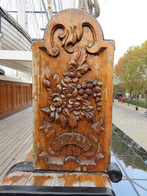
... Cutty Sark vessel and exhibition, Greenwich, England, wood carving...Every year until 1895 she set out in the summer for Australia, to load a cargo of wool bales and return to England in time for the wool sales ini the first three months of the new year. ...Wood carving from the Cutty Sark vessel and exhibition, Greenwich, England....England...Cutty sark exhibition wool Australia sailing woodget moodie london willis dumbarton scott & Linton william Denny tea cargo immigration trade Wood carving from the Cutty Sark vessel and exhibition, Greenwich, England. Cutty Sark vessel and exhibition, Greenwich, England, wood carving Photograph Photograph - Colour ...The Cutty Sark was launched on 22 November 1869. She was named by the wife of George Moodie, the ship's first master who had also supervised her construction. Cutty Sark left the Clyde on 13 January 1870. A month and two days later, she set sail from London for China. Cutty sark was designed and built by Scott & Linton of Dumbarton for 16,150 pounds. But much of the money was to be paid by Willis when the ship was launched. Just before they finished her, Scott & Linton ran out of money and went bankrupt. She was completed by William Denny & Brothers. The Cutty Sark was the first ship to reach London with a tea cargo in 1877. But she was one of only nine sailing ships that returned that year - in 1870 there had been 59. Steamships were now dominating the tea trade. In 1883 the Cutty Sark joined the booming trade in transporting Australian wool. Every year until 1895 she set out in the summer for Australia, to load a cargo of wool bales and return to England in time for the wool sales ini the first three months of the new year. Cutty Sark soon established herself as the fastest of the wool clippers. Under her last master, Richard Woodget she set record times of 70 days or less for the voyage which no other sailing ships could match.Wood carving from the Cutty Sark vessel and exhibition, Greenwich, England.cutty sark, exhibition, wool, australia, sailing, woodget, moodie, london, willis, dumbarton, scott & linton, william denny, tea, cargo, immigration, trade -
 Ballarat Heritage Services
Photograph - Photograph - Colour, Churchyard, Alwington, Devon, England, 2017
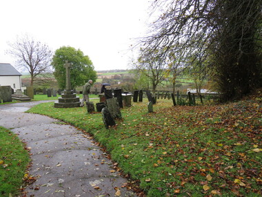
... Churchyard, Alwington, Devon, England......England...Churchyard, Alwington, Devon, England...Ballarat Heritage Services PO Box 2209 Bakery Hill Post Office goldfields Churchyard Alwington Devon England cemetery Churchyard, Alwington, Devon, England Churchyard, Alwington, Devon, England Photograph Photograph - Colour ...Churchyard, Alwington, Devon, Englandchurchyard, alwington, devon, england, cemetery -
 Ballarat Heritage Services
Photograph - Colour, Glastonbury Abbey, England, 2017, 2017
... Glastonbury Abbey, England, 2017...Colour photograph of Glastonbury Abbey, England....England...Ballarat Heritage Services PO Box 2209 Bakery Hill Post Office goldfields glastonbury abbey Colour photograph of Glastonbury Abbey, England. Glastonbury Abbey, England, 2017 Photograph - Colour ...Colour photograph of Glastonbury Abbey, England.glastonbury abbey -
Ringwood and District Historical Society
Badge, Badge with the Coat of Arms of Ringwood, England
... Badge with the Coat of Arms of Ringwood, England....Given to Ellie Pullin during a visit to Ringwood, England. The coat of arms is of the English Ringwood. ...Given to Ellie Pullin during a visit to Ringwood, England. The coat of arms is of the English Ringwood. ...England...+Additional Keywords: Pullin, Ellie Badge with the Coat of Arms of Ringwood, England. Badge ...Given to Ellie Pullin during a visit to Ringwood, England. The coat of arms is of the English Ringwood. Ellie Pullin was a long serving member of the Ringwood Historical Research Group.Small oval badge with unusual clasp at back. Metal, brass coloured, with crown over shield in blue enamel. Given to Ellie Pullin during a visit to Ringwood, England. The coat of arms is of the English Ringwood. +Additional Keywords: Pullin, Ellie -
 Narre Warren and District Family History Group
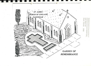
Book, St James Church of England - Garden of Remembrance, St James Church of England, Pakenham Garden of Remembrance, 1994
... St James Church of England, Pakenham Garden of Remembrance...St James Church of England - Garden of Remembrance...Narre Warren and District Family History Group 110 High Street Berwick melbourne St James Church Pakenham Garden of remembrance Over 80 people are remembered here in the garden St James Church of England, Pakenham Garden of Remembrance Book St James Church of England - Garden of Remembrance ...Over 80 people are remembered here in the gardennon-fictionOver 80 people are remembered here in the gardenst james church pakenham, garden of remembrance -
 Lakes Entrance Historical Society
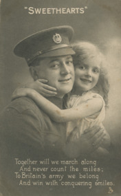
Postcard - Private CR Sands 1917, Raphael Tuck and Sons England
... Black and white postcard of British soldier and a little girl. England...Raphael Tuck and Sons England...England...Charles Australian soldier waiting to go into battle World War 1914-1918 Communications I Love a Lassie Black and white postcard of British soldier and a little girl. England Postcard Private CR Sands 1917 Raphael Tuck and Sons England ...message continued from 05475...we went out snow balling one another and had some fine fun, and then we made a snowman had our photo taken alongside him. Well little Dorothy I am going to France next week so I will not get a chance to write very often so I will say goodnight for this time. CharlesAustralian soldier waiting to go into battleBlack and white postcard of British soldier and a little girl. EnglandI Love a Lassieworld war 1914-1918, communications -
 Ballarat Heritage Services
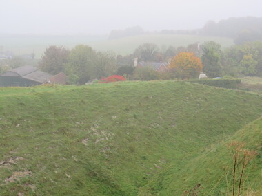
Photograph - Colour, Earth Banks, Old Sarum, England, 2016, 01 November 2016
... Earth Banks, Old Sarum, England, 2016......england...William the Conqueror inherited Old Sarum from the last Saxon king of England. It was an ideal site for a royal castle. ...Old Sarum, England...It was here in 1070 that William paid off his army after a long and bitter campaign in northern England. It was here in 1086 that he called together all the major landholders in England so they could swear allegiance to him. ...William the Conqueror inherited Old Sarum from the last Saxon king of England. It was an ideal site for a royal castle. It was here in 1070 that William paid off his army after a long and bitter campaign in northern England. It was here in 1086 that he called together all the major landholders in England so they could swear allegiance to him. It was a crucial moment. The Domesday Book was being written, a threatened Viking invasion had only just been averted and William's eldest son was in armed rebellion. Old Sarum was an important place where this Norman king of England held power. In 1794 the Ordnance Survey set out to check the accuracy of the first mapping of Southern England, which had begun ten years earlier. From a point just below Old Sarum Lieutenant William Mudge laid out a base-line 36,574 feet (11,253 metres) long. From each end of the line the positions of distant places were plotted using a huge theodolite made in 1791 by Jesse Ramsden. The accuracy of the process, which was repeated all over England, depended on Jesse Ramsden's craftsmanship and on William Mudge's surveying skill in setting out this first base-line from Old Sarum. The nearer end of Mudge's line is marked by an inscribed stone beside the modern A345 at Old Sarum. ordnance survey, william mudge, jesse ramsden, william the conqueror, old sarum, saxon, 1086, england -
 Ballarat Heritage Services
Photograph - Colour, Earth Banks, Old Sarum, England, 01 November 2016
... Earth Banks, Old Sarum, England......england...William the Conqueror inherited Old Sarum from the last Saxon king of England. It was an ideal site for a royal castle. ...Old Sarum, England...It was here in 1070 that William paid off his army after a long and bitter campaign in northern England. It was here in 1086 that he called together all the major landholders in England so they could swear allegiance to him. ...William the Conqueror inherited Old Sarum from the last Saxon king of England. It was an ideal site for a royal castle. It was here in 1070 that William paid off his army after a long and bitter campaign in northern England. It was here in 1086 that he called together all the major landholders in England so they could swear allegiance to him. It was a crucial moment. The Domesday Book was being written, a threatened Viking invasion had only just been averted and William's eldest son was in armed rebellion. Old Sarum was an important place where this Norman king of England held power. In 1794 the Ordnance Survey set out to check the accuracy of the first mapping of Southern England, which had begun ten years earlier. From a point just below Old Sarum Lieutenant William Mudge laid out a base-line 36,574 feet (11,253 metres) long. From each end of the line the positions of distant places were plotted using a huge theodolite made in 1791 by Jesse Ramsden. The accuracy of the process, which was repeated all over England, depended on Jesse Ramsden's craftsmanship and on William Mudge's surveying skill in setting out this first base-line from Old Sarum. The nearer end of Mudge's line is marked by an inscribed stone beside the modern A345 at Old Sarum. ordnance survey, william mudge, jesse ramsden, william the conqueror, old sarum, saxon, 1086, england -
 Ballarat Heritage Services
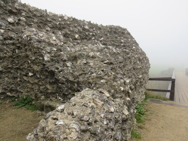
Photograph - Colour, Stonework, Old Sarum, England, English Heritage Site, 01 November 2016
... Stonework, Old Sarum, England, English Heritage Site......england...William the Conqueror inherited Old Sarum from the last Saxon king of England. It was an ideal site for a royal castle. ...Old Sarum, England...It was here in 1070 that William paid off his army after a long and bitter campaign in northern England. It was here in 1086 that he called together all the major landholders in England so they could swear allegiance to him. ...William the Conqueror inherited Old Sarum from the last Saxon king of England. It was an ideal site for a royal castle. It was here in 1070 that William paid off his army after a long and bitter campaign in northern England. It was here in 1086 that he called together all the major landholders in England so they could swear allegiance to him. It was a crucial moment. The Domesday Book was being written, a threatened Viking invasion had only just been averted and William's eldest son was in armed rebellion. Old Sarum was an important place where this Norman king of England held power. In 1794 the Ordnance Survey set out to check the accuracy of the first mapping of Southern England, which had begun ten years earlier. From a point just below Old Sarum Lieutenant William Mudge laid out a base-line 36,574 feet (11,253 metres) long. From each end of the line the positions of distant places were plotted using a huge theodolite made in 1791 by Jesse Ramsden. The accuracy of the process, which was repeated all over England, depended on Jesse Ramsden's craftsmanship and on William Mudge's surveying skill in setting out this first base-line from Old Sarum. The nearer end of Mudge's line is marked by an inscribed stone beside the modern A345 at Old Sarum. ordnance survey, william mudge, jesse ramsden, william the conqueror, old sarum, saxon, 1086, england -
 Ballarat Heritage Services
Photograph - Colour, Stonework, Old Sarum, England, English Heritage Site, 01 November 2016
... Stonework, Old Sarum, England, English Heritage Site......england...William the Conqueror inherited Old Sarum from the last Saxon king of England. It was an ideal site for a royal castle. ...Old Sarum, England...It was here in 1070 that William paid off his army after a long and bitter campaign in northern England. It was here in 1086 that he called together all the major landholders in England so they could swear allegiance to him. ...William the Conqueror inherited Old Sarum from the last Saxon king of England. It was an ideal site for a royal castle. It was here in 1070 that William paid off his army after a long and bitter campaign in northern England. It was here in 1086 that he called together all the major landholders in England so they could swear allegiance to him. It was a crucial moment. The Domesday Book was being written, a threatened Viking invasion had only just been averted and William's eldest son was in armed rebellion. Old Sarum was an important place where this Norman king of England held power. In 1794 the Ordnance Survey set out to check the accuracy of the first mapping of Southern England, which had begun ten years earlier. From a point just below Old Sarum Lieutenant William Mudge laid out a base-line 36,574 feet (11,253 metres) long. From each end of the line the positions of distant places were plotted using a huge theodolite made in 1791 by Jesse Ramsden. The accuracy of the process, which was repeated all over England, depended on Jesse Ramsden's craftsmanship and on William Mudge's surveying skill in setting out this first base-line from Old Sarum. The nearer end of Mudge's line is marked by an inscribed stone beside the modern A345 at Old Sarum. ordnance survey, william mudge, jesse ramsden, william the conqueror, old sarum, saxon, 1086, england -
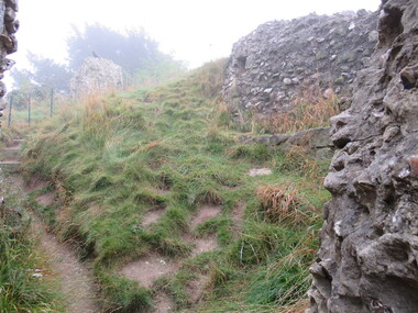
 Ballarat Heritage Services
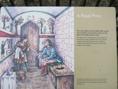
Photograph - Colour, Sign Explaining toilets, Old Sarum, England, English Heritage Site, 01/11/2016
... Sign Explaining toilets, Old Sarum, England, English Heritage Site......england...William the Conqueror inherited Old Sarum from the last Saxon king of England. It was an ideal site for a royal castle. ...Old Sarum, England...It was here in 1070 that William paid off his army after a long and bitter campaign in northern England. It was here in 1086 that he called together all the major landholders in England so they could swear allegiance to him. ...William the Conqueror inherited Old Sarum from the last Saxon king of England. It was an ideal site for a royal castle. It was here in 1070 that William paid off his army after a long and bitter campaign in northern England. It was here in 1086 that he called together all the major landholders in England so they could swear allegiance to him. It was a crucial moment. The Domesday Book was being written, a threatened Viking invasion had only just been averted and William's eldest son was in armed rebellion. Old Sarum was an important place where this Norman king of England held power. In 1794 the Ordnance Survey set out to check the accuracy of the first mapping of Southern England, which had begun ten years earlier. From a point just below Old Sarum Lieutenant William Mudge laid out a base-line 36,574 feet (11,253 metres) long. From each end of the line the positions of distant places were plotted using a huge theodolite made in 1791 by Jesse Ramsden. The accuracy of the process, which was repeated all over England, depended on Jesse Ramsden's craftsmanship and on William Mudge's surveying skill in setting out this first base-line from Old Sarum. The nearer end of Mudge's line is marked by an inscribed stone beside the modern A345 at Old Sarum. Colour photograph of a sign explaining toilets at Old Sarum, English Heritage Siteordnance survey, william mudge, jesse ramsden, william the conqueror, old sarum, saxon, 1086,, england -
 Flagstaff Hill Maritime Museum and Village
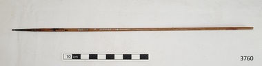
Functional object - Brush, 1930-1955's
... REEVES - Reeves & Sons Ltd, makers of fine art supplies, operated under this name in London, England, 1891-1976. The company was founded as Thomas Reeves and Son in 1784. ...Paint brush, narrow ‘0’ size, Reeves brand, no. 157, made in England. Inscription printed in silver paint. ...Printed on handle -“MADE IN / ENGLAND” , “REEVES”, “157”, “0”...Reeves of England...Functional object Brush Reeves of England ...This fine Reeves paint brush was used in the making of components for the ship model Sovereign of the Seas. It is part of a collection of objects used by Jim Williams, maker of fine ship models from about 1930-1955. Most of the components for the models, as well as many of the tools, were handmade by Jim Williams. Jim’s family has donated the ship model “Sovereign of the Seas” and many tools, accessories and documents used in the making of this and other ship models have been donated to Flagstaff Hill Maritime Village. REEVES - Reeves & Sons Ltd, makers of fine art supplies, operated under this name in London, England, 1891-1976. The company was founded as Thomas Reeves and Son in 1784. SOVEREIGN OF THE SEAS - Ship model of HMS Sovereign of the Seas, scale model of 17th Century English war ship, was handmade and carved from plans, enclosed in airtight glass case. All components of that model, including even the smallest pulleys, were hand crafted using tools designed and made by Jim. Outstanding details include functional rigging and moving cannons. Please see our record 3732 of the mode Sovereign of the Seas for further details of the ship and the maker. This brush is connected with the hobby and skill of ship model making that has been crafted as a leisure activity for many generations. The hobby is often chosen by serving and retired mariners who appreciate the connection with maritime history. This brush was used by local Warrnambool man, Jim Williams, who was employed at Cramond and Dickson clothing store, and then at Fletcher Jones menswear for 27 years. It was used in making components for the model of the historic ship, the Sovereign of the Seas. The Sovereign of the Seas was a historic 17th century English war ship with important maritime heritage. Paint brush, narrow ‘0’ size, Reeves brand, no. 157, made in England. Inscription printed in silver paint. This paint brush is part of a collection of tools and accessories once used by Jim Williams, maker of a series of ship models 1930-1955 including “HMS Sovereign of the Seas”. Printed on handle -“MADE IN / ENGLAND” , “REEVES”, “157”, “0”flagstaff hill, warrnambool, flagstaff hill maritime museum, maritime museum, shipwreck coast, flagstaff hill maritime village, great ocean road, jim williams, james bernard williams, ship model hobby, ship model tools, ship model making equipment, ship model making accessories, paint brush, reeves of england, sovereign of the sea, ship model, hobby, ship model tool, brush -
 Robin Boyd Foundation
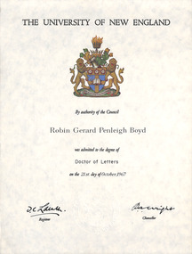
Certificate, Degree of Doctor of Letters University of New England, 1967
... Degree of Doctor of Letters University of New England...Zelman Cowen was Vice Chancellor at University of New England 1967-1970. Robin Boyd designed Zelman Cohen House at 34 Yarravale Road in Kew in 1959. ...Certificate from The University of New England, with University crest, signed by two people. ...The University of New England. By authority of the Council Robin Gerard Penleigh Boyd was admitted to the Degree of Doctor of Letters on the 21st day of October 1967. ...UNE University of New England Zelman Cowen Doctor of Letters Robin Boyd OHM2022 OHM2022_42 The University of New England. ...Robin Gerard Penleigh Boyd was admitted to the degree of Doctor of Letters on the 21st day of October 1967 at University of New England. The family attended the outdoor ceremony and have slides of Robin Boyd in full academic dress. The Academic dress hood is part of the Walsh Street Archive (item F069). Zelman Cowen was Vice Chancellor at University of New England 1967-1970. Robin Boyd designed Zelman Cohen House at 34 Yarravale Road in Kew in 1959. Certificate from The University of New England, with University crest, signed by two people. Rolled into a red leather cylindrical holder with Robin Gerard Penleigh Boyd embossed in gold along long axis (item F168).The University of New England. By authority of the Council Robin Gerard Penleigh Boyd was admitted to the Degree of Doctor of Letters on the 21st day of October 1967. Signature of the Registrar JC Lainth (indecipherable) and Chancellor PA Wright.une, university of new england, zelman cowen, doctor of letters, robin boyd, ohm2022, ohm2022_42 -
Ringwood and District Historical Society
Envelope, Packet: Ringwood England - History and other printed matter, 1960
... Packet: Ringwood England - History and other printed matter....Ringwood Hants, England - booklet "The Ringwood Story" 28 pages typed notes...Ringwood, England...Ringwood and District Historical Society 125A Warrandyte Road Ringwood North melbourne Ringwood Hants, England - booklet "The Ringwood Story" 28 pages typed notes Packet: Ringwood England - History and other printed matter. ...Ringwood Hants, England - booklet "The Ringwood Story" 28 pages typed notes -
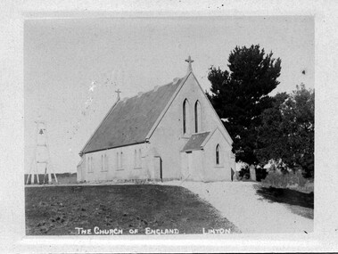 Linton and District Historical Society Inc
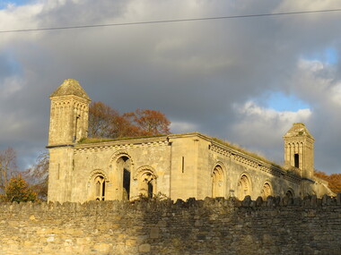
Photograph, Church of England, Linton
... Church of England, Linton... The Linton Church of England was opened for public worship in 1862....Sepia postcard photograph of the Church of England building in Linton....Church of England, Linton Photograph ...The Linton Church of England was opened for public worship in 1862.Sepia postcard photograph of the Church of England building in Linton.Postcardchurch of england, buildings, st paul's anglican church