Showing 130 items matching " erosion"
-
 Stawell Historical Society Inc
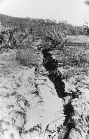
Photograph, Bushfire damage showing Soil Erosion 1939
... Bushfire damage showing Soil Erosion 1939...Scene showing soil erosion after 1939 bushfire. ...Black and white photograph of a ravine down the side of a hill. The erosion has resulted from the 1939 bush fire....The erosion has resulted from the 1939 bush fire. ...Scene showing soil erosion after 1939 bushfire. Black and white photograph of a ravine down the side of a hill. The erosion has resulted from the 1939 bush fire.stawell -
 Greensborough Historical Society
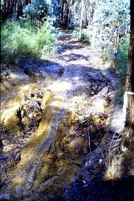
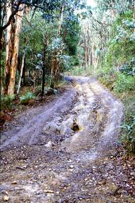
Slide - Photograph, John Ramsdale, Erosion from trail bikes: Slide 36, 1990s
... Erosion from trail bikes: Slide 36...erosion...Photograph shows a bush track with erosion caused by trail bikes and water....Greensborough Historical Society 34A Glenauburn Road Lower Plenty Lower Plenty melbourne Photograph shows a bush track with erosion caused by trail bikes and water. Part of the John Ramsdale collection of slides and audio visual material. erosion bushland No maker's marks. ...Photograph shows a bush track with erosion caused by trail bikes and water.Part of the John Ramsdale collection of slides and audio visual material.Colour photograph scanned from slide.No maker's marks. No caption on slide.erosion, bushland -
 Greensborough Historical Society
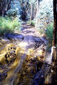
Slide - Photograph, John Ramsdale, Gully erosion - motorbike track: Slide 77, 1990s
... Gully erosion - motorbike track: Slide 77...erosion...Photograph shows a washed out bush track - Gully erosion caused by motorbike track...Greensborough Historical Society 34A Glenauburn Road Lower Plenty Lower Plenty melbourne Photograph shows a washed out bush track - Gully erosion caused by motorbike track Part of the John Ramsdale collection of slides and audio visual material. erosion gully erosion No maker's marks. ...Photograph shows a washed out bush track - Gully erosion caused by motorbike trackPart of the John Ramsdale collection of slides and audio visual material.Colour photograph scanned from slide.No maker's marks. No caption on slide.erosion, gully erosion -
 Greensborough Historical Society
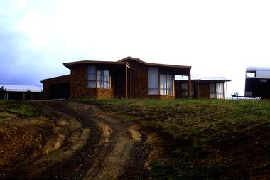
Slide - Photograph, John Ramsdale, Erosion, South Morang: Slide 113, 1990s
... Erosion, South Morang: Slide 113......erosion...Photograph shows a house with horse float and erosion on a poorly maintained driveway, Gorge Road South Morang. ...Colour photograph scanned from slide. Erosion, South Morang: Slide 113 Slide Photograph John Ramsdale ...Photograph shows a house with horse float and erosion on a poorly maintained driveway, Gorge Road South Morang. Part of the John Ramsdale collection of slides and audio visual material.Colour photograph scanned from slide.No maker's marks. No caption on slide.gorge road south morang, erosion -
 Greensborough Historical Society
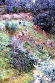
Slide - Photograph, John Ramsdale, Slumping erosion along the Plenty River: Slide 110, 1990s
... Slumping erosion along the Plenty River: Slide 110......erosion...This is slumping erosion along the Plenty River....This is slumping erosion along the Plenty River. Part of the John Ramsdale collection of slides and audio visual material. plenty river erosion No maker's marks. ...Photograph shows a man standing on an embankment which is being eroded. This is slumping erosion along the Plenty River.Part of the John Ramsdale collection of slides and audio visual material.Colour photograph scanned from slide.No maker's marks. Caption on slide "Plenty"plenty river, erosion -
 Greensborough Historical Society
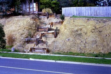
Slide - Photograph, John Ramsdale, Rattray Road erosion: Slide 2, 1990s
... Rattray Road erosion: Slide 2...erosion...Photograph shows a retaining wall leading up an embankment to a fence line. This shows erosion on Rattray Road Montmorency....Rattray Road erosion: Slide 2 Slide Photograph John Ramsdale ...Photograph shows a retaining wall leading up an embankment to a fence line. This shows erosion on Rattray Road Montmorency.Part of the John Ramsdale collection of slides and audio visual material.Colour photograph scanned from slide.erosion, rattray road montmorency -
 Greensborough Historical Society
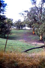
Slide - Photograph, John Ramsdale, Erosion on overgrazed property: Slide 125, 1990s
... Erosion on overgrazed property: Slide 125......erosion...Photograph shows a fenced paddock and gum trees; erosion on overgrazed property near Whittlesea....Colour photograph scanned from slide. Erosion on overgrazed property: Slide 125 Slide Photograph John Ramsdale ...Photograph shows a fenced paddock and gum trees; erosion on overgrazed property near Whittlesea.Part of the John Ramsdale collection of slides and audio visual material.Colour photograph scanned from slide.No maker's marks. No caption on slide.whittlesea, erosion, farming -
 Greensborough Historical Society
Slide - Photograph, John Ramsdale, Erosion on overgrazed property: Slide 124, 1990s
... Erosion on overgrazed property: Slide 124......erosion...Photograph shows a fenced paddock and gum trees; this is sheet erosion on an overgrazed property near Whittlesea....Colour photograph scanned from slide. Erosion on overgrazed property: Slide 124 Slide Photograph John Ramsdale ...Photograph shows a fenced paddock and gum trees; this is sheet erosion on an overgrazed property near Whittlesea.Part of the John Ramsdale collection of slides and audio visual material.Colour photograph scanned from slide.No maker's marks. No caption on slide.whittlesea, erosion, farming -
 Eltham District Historical Society Inc
Work on paper (Sub-Item) - Photograph, Bank erosion on Deep Creek, 1976
... Bank erosion on Deep Creek......erosion...Colour photograph of creek bank erosion on Deep Creek probably at Arthurs Creek...Eltham District Historical Society Inc 728 Main Rd Eltham melbourne Colour photograph of creek bank erosion on Deep Creek probably at Arthurs Creek arthurs creek Deep creek erosion bank Image printed on A4 page from 04997 Diamond Creek Basin Study, 1980 Bank erosion on Deep Creek Work on paper Photograph ...Colour photograph of creek bank erosion on Deep Creek probably at Arthurs Creekarthurs creek, deep creek, erosion, bank -
 Eltham District Historical Society Inc
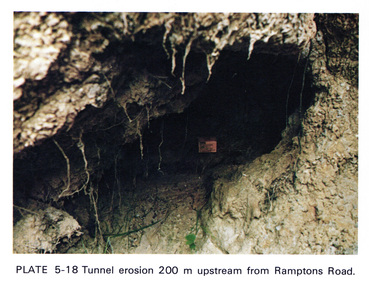
Work on paper (Sub-Item) - Photograph, Tunnel erosion 220 m upstream from Ramptons Road
... Tunnel erosion 220 m upstream from Ramptons Road......erosion...Colour photograph of tunnel erosion 220 metres upstream from Ramptons Road, Eltham North ...Eltham District Historical Society Inc 728 Main Rd Eltham melbourne Colour photograph of tunnel erosion 220 metres upstream from Ramptons Road, Eltham North eltham erosion eltham north drain Image printed on A4 page from 04997 Diamond Creek Basin Study, 1980 Tunnel erosion 220 m upstream from Ramptons Road Work on paper Photograph ...Colour photograph of tunnel erosion 220 metres upstream from Ramptons Road, Eltham North eltham, erosion, eltham north, drain -
 Eltham District Historical Society Inc
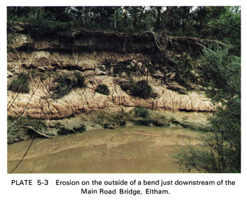
Work on paper (Sub-Item) - Photograph, Erosion on the outside of a bend just downstream of the Main Road Bridge, Eltham
... Erosion on the outside of a bend just downstream of the Main Road Bridge, Eltham......erosion...Colour photograph of a muddy Diamond Creek (probably after a downpour) with siginificant water erosion apparent at the bend of the creek in Eltham....Eltham District Historical Society Inc 728 Main Rd Eltham melbourne Colour photograph of a muddy Diamond Creek (probably after a downpour) with siginificant water erosion apparent at the bend of the creek in Eltham. eltham creek vegetation Diamond Creek erosion Image printed on A4 page from 04997 Diamond Creek Basin Study, 1980 Erosion on the outside of a bend just downstream of the Main Road Bridge, Eltham Work on paper Photograph ...Colour photograph of a muddy Diamond Creek (probably after a downpour) with siginificant water erosion apparent at the bend of the creek in Eltham.eltham, creek, vegetation, diamond creek, erosion -
 Eltham District Historical Society Inc
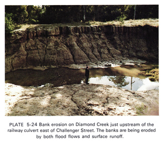
Work on paper (Sub-Item) - Photograph, Bank erosion on Diamond Creek just upstream of the railway culvert east of Challenger Street
... Bank erosion on Diamond Creek just upstream of the railway culvert east of Challenger Street......erosion...Colour photograph of bank erosion on Diamond Creek just upstream of the railway culvert east of Challenger Street in Diamond Creek township. ...The banks are eroded by both flood flows and surface runoff eltham drain diamond creek erosion Challenger Street Image printed on A4 page from 04997 Diamond Creek Basin Study, 1980 Bank erosion on Diamond Creek just upstream of the railway culvert east of Challenger Street Work on paper Photograph ...Colour photograph of bank erosion on Diamond Creek just upstream of the railway culvert east of Challenger Street in Diamond Creek township. The banks are eroded by both flood flows and surface runoffeltham, drain, diamond creek, erosion, challenger street -
 Glenelg Shire Council Cultural Collection
Photograph - Photograph - Casterton, Victoria, n.d
... ... erosion...Black and white photo. Erosion near Casterton...Erosion near Casterton Photograph Photograph - Casterton, Victoria J.T. ...SOURCED FROM CASTERTON TOWN HALL (FORMER SHIRE OF GLENELG)Black and white photo. Erosion near CastertonBack: Round purple photographer's stamptourism, erosion, casterton -
 Eltham District Historical Society Inc
Photograph, Fred Mitchell, Erosion after construction, Diamond Creek Trail, 25 February 2015, 25/02/2015
... Erosion after construction, Diamond Creek Trail, 25 February 2015...Eltham District Historical Society Inc 728 Main Rd Eltham melbourne fred mitchell collection diamond creek trail 2015 Digital copy of colour photograph Erosion after construction, Diamond Creek Trail, 25 February 2015 Photograph Fred Mitchell ...Digital copy of colour photographfred mitchell collection, diamond creek trail, 2015 -
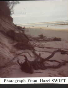
 Inverloch Historical Society
001375 - Photograph - Inverloch - beach erosion on foreshore - c1977 - from Hazel Swift
... 001375 - Photograph - Inverloch - beach erosion on foreshore - c1977 - from Hazel Swift...Inverloch gippsland 001375 - Photograph - Inverloch - beach erosion on foreshore - c1977 - from Hazel Swift ... -
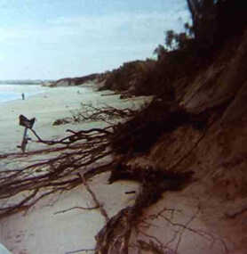
 Inverloch Historical Society
001378 - Photograph - Inverloch - Surf Beach - erosion of foreshore - from Hazel Swift
... 001378 - Photograph - Inverloch - Surf Beach - erosion of foreshore - from Hazel Swift...Inverloch gippsland 001378 - Photograph - Inverloch - Surf Beach - erosion of foreshore - from Hazel Swift ... -
 Inverloch Historical Society
000865 - Photograph - 1972 or 1977 - Inverloch - Beach erosion on surf beach - from Hazel Swift
... 000865 - Photograph - 1972 or 1977 - Inverloch - Beach erosion on surf beach - from Hazel Swift...Inverloch gippsland 000865 - Photograph - 1972 or 1977 - Inverloch - Beach erosion on surf beach - from Hazel Swift ... -
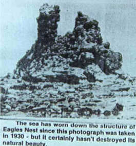 Inverloch Historical Society
000670 - Photograph - 1930 - Inverloch - Eagles Nest Erosion - from N Deacon
... 000670 - Photograph - 1930 - Inverloch - Eagles Nest Erosion - from N Deacon...Inverloch gippsland 000670 - Photograph - 1930 - Inverloch - Eagles Nest Erosion - from N Deacon ... -
Creswick Campus Historical Collection - University of Melbourne
Book, Soil Erosion in Victoria. A symposium arranged by the Victorian Institute of Surveyors, 1940
... Soil Erosion in Victoria. A symposium arranged by the Victorian Institute of Surveyors....Torbett Documents Soil Erosion in Victoria. A symposium arranged by the Victorian Institute of Surveyors. ...Series of papers from a symposium arranged by the Victorian Institute of Surveyors. 1940. 2 x copies.DocumentsE.R. Torbett -
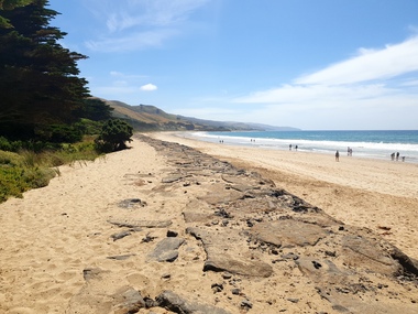
 Phillip Island and District Historical Society Inc.
Photograph, H. R. Balfour
... ...erosion...Photograph demonstrating erosion at Forrest Midden...Phillip Island and District Historical Society Inc. phillip-island-and-the-bass-coast One of a collection of over 400 photographs in an album commenced in 1960 and presented to the Phillip Island & Westernport Historical Society by the Shire of Phillip Island local history photography eroded knoll black & white photograph erosion forrest midden H R Balfour John Jenner Bryant West Photograph demonstrating erosion at Forrest Midden Photograph Bryant West H. ...One of a collection of over 400 photographs in an album commenced in 1960 and presented to the Phillip Island & Westernport Historical Society by the Shire of Phillip IslandPhotograph demonstrating erosion at Forrest Middenlocal history, photography, eroded knoll, black & white photograph, erosion, forrest midden, h r balfour, john jenner, bryant west -
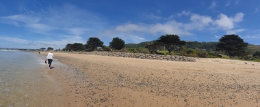
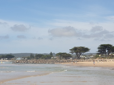 Ballarat Heritage Services
Photograph, Clare Gervasoni, Apollo Bay, Victoria, 24/01/2022
... Sections of rock seawall will be constructed between the two Groynes with an aim to protect the dune, walking path, cypress trees and road from erosion. ...Colour photograph of a coastal scene at Apollo Bay, featuring new rock groynes to protect the Great Ocean Road from erosion. ...Sections of rock seawall will be constructed between the two Groynes with an aim to protect the dune, walking path, cypress trees and road from erosion. Apollo bay beach coast groyne rockwall Colour photograph of a coastal scene at Apollo Bay, featuring new rock groynes to protect the Great Ocean Road from erosion. ...In 2021, the Department of Environment, Land, Water and Planning (DELWP) constructed two new groynes and a section of rock seawall at Apollo Bay to help manage the impacts of coastal erosion. The new 70-meter-long rock groynes run perpendicular to the shoreline and be located just south of the Milford St revetment and to the south of Milford Creek. Sections of rock seawall will be constructed between the two Groynes with an aim to protect the dune, walking path, cypress trees and road from erosion. Colour photograph of a coastal scene at Apollo Bay, featuring new rock groynes to protect the Great Ocean Road from erosion. apollo bay, beach, coast, groyne, rockwall -
 Ballarat Heritage Services
Photograph, Clare Gervasoni, Apollo Bay, Victoria, 24/01/2022
... Sections of rock seawall will be constructed between the two Groynes with an aim to protect the dune, walking path, cypress trees and road from erosion. ...Colour photograph of a coastal scene at Apollo Bay, featuring new rock wall and groynes to protect the Great Ocean Road from erosion. ...Sections of rock seawall will be constructed between the two Groynes with an aim to protect the dune, walking path, cypress trees and road from erosion. Apollo bay beach coast groyne rockwall Colour photograph of a coastal scene at Apollo Bay, featuring new rock wall and groynes to protect the Great Ocean Road from erosion. ...In 2021, the Department of Environment, Land, Water and Planning (DELWP) constructed two new groynes and a section of rock seawall at Apollo Bay to help manage the impacts of coastal erosion. The new 70-meter-long rock groynes run perpendicular to the shoreline and be located just south of the Milford St revetment and to the south of Milford Creek. Sections of rock seawall will be constructed between the two Groynes with an aim to protect the dune, walking path, cypress trees and road from erosion. Colour photograph of a coastal scene at Apollo Bay, featuring new rock wall and groynes to protect the Great Ocean Road from erosion. apollo bay, beach, coast, groyne, rockwall -
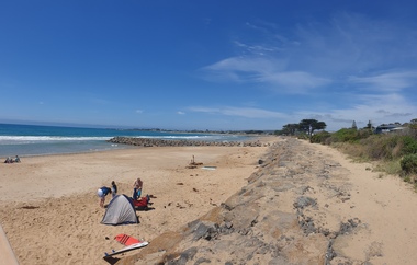
 Ballarat Heritage Services
Photograph, Clare Gervasoni, Sea Wall at Apollo Bay, Victoria, 24/01/2022
... Sections of rock seawall will be constructed between the two Groynes with an aim to protect the dune, walking path, cypress trees and road from erosion. ...Colour photograph of a coastal scene at Apollo Bay, featuring new rock wall and groynes to protect the Great Ocean Road from erosion. ...Sections of rock seawall will be constructed between the two Groynes with an aim to protect the dune, walking path, cypress trees and road from erosion. Apollo bay beach coast groyne rockwall sea wall Colour photograph of a coastal scene at Apollo Bay, featuring new rock wall and groynes to protect the Great Ocean Road from erosion. ...In 2021, the Department of Environment, Land, Water and Planning (DELWP) constructed two new groynes and a section of rock seawall at Apollo Bay to help manage the impacts of coastal erosion. The new 70-meter-long rock groynes run perpendicular to the shoreline and be located just south of the Milford St revetment and to the south of Milford Creek. Sections of rock seawall will be constructed between the two Groynes with an aim to protect the dune, walking path, cypress trees and road from erosion. Colour photograph of a coastal scene at Apollo Bay, featuring new rock wall and groynes to protect the Great Ocean Road from erosion. apollo bay, beach, coast, groyne, rockwall, sea wall -
 Greensborough Historical Society
Slide - Photograph, John Ramsdale, Barbers Creek, Mernda: Slide 6, 1990s
... erosion...Photograph shows washed out bush track with gully erosion at Barbers Creek, Mernda....Greensborough Historical Society 34A Glenauburn Road Lower Plenty Lower Plenty melbourne Photograph shows washed out bush track with gully erosion at Barbers Creek, Mernda. Part of the John Ramsdale collection of slides and audio visual material. erosion barbers creek mernda No maker's marks. ...Photograph shows washed out bush track with gully erosion at Barbers Creek, Mernda.Part of the John Ramsdale collection of slides and audio visual material.Colour photograph scanned from slide.No maker's marks. No caption on slide.erosion, barbers creek mernda -
 Greensborough Historical Society
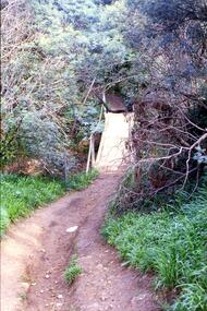
Slide - Photograph, John Ramsdale, Crossing Plenty River: Slide 12, 1990s
... ...erosion...Photograph shows erosion on a path to a footbridge over the Plenty River down from George Court Montmorency....Greensborough Historical Society 34A Glenauburn Road Lower Plenty Lower Plenty melbourne Photograph shows erosion on a path to a footbridge over the Plenty River down from George Court Montmorency. ...Photograph shows erosion on a path to a footbridge over the Plenty River down from George Court Montmorency.Part of the John Ramsdale collection of slides and audio visual material.Colour photograph scanned from slide.No maker's marks. No caption on slide.plenty river, erosion, montmorency -
 Phillip Island and District Historical Society Inc.
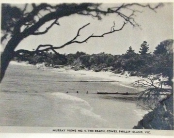
Photograph, Murray Views, Cowes East Beach
... ...Erosion...Groynes were erected to help with erosion on the beach....Phillip Island and District Historical Society Inc. phillip-island-and-the-bass-coast Groynes were erected to help with erosion on the beach. Photographs Cowes Cowes Beach Erosion Postcards Murray Views No. 4 The Beach Cowes, Phillip Island, Vic Small black and white photo of the beach to the east of Cowes, showing groynes. ...Groynes were erected to help with erosion on the beach.Small black and white photo of the beach to the east of Cowes, showing groynes. Murray Views No. 4 The Beach Cowes, Phillip Island, Vicphotographs, cowes, cowes beach, erosion, postcards -
 Running Rabbits Military Museum operated by the Upwey Belgrave RSL Sub Branch
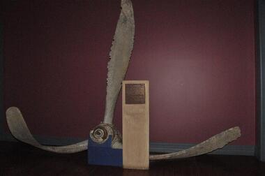
Propeller from Crashed RAAF B-25 MITCHELL A47-24 BOMBER, The North American Aviation Company, RAAF Bomber A47-24, 1944
... None. Sea erosion of the Aluminium is very evident....This Propeller was recovered after becoming entangled in fishing nets. propeller b25 bomber crash torquay pt addis None. Sea erosion of the Aluminium is very evident. A47-24 Propeller RAAF Bomber A47-24 Propeller from Crashed RAAF B-25 MITCHELL A47-24 BOMBER The North American Aviation Company ...The A47-24 was a B-25D MITCHELL,a twin-engined medium bomber built by NORTH AMERICAN AVIATION COMPANY in Kansas City U.S.A. Initially issued for use by the Netherlands East Indies Air Force as N5-216, The Aircraft was taken on charge by the RAAF in 1944. On the 01/12/44, A47-24 was undergoing flight trials over the Torquay Bombing Range off Pt. Addis,when it appeared to catch fire and subsequently crashed into the sea. Of it's crew of 5,3 were killed. This Propeller was recovered after becoming entangled in fishing nets. A47-24 PropellerNone. Sea erosion of the Aluminium is very evident.propeller, b25 bomber, crash, torquay, pt addis -
Glenelg Shire Council Cultural Collection
Photograph - Photograph - Dutton Way, Portland, n.d
... ... erosion...Black & white photo showing erosion of Dutton Way. Sewrage pipe from house can be seen in the water. ...Glenelg Shire Council Cultural Collection History House Cliff Street Portland great-ocean-road Port of Portland Authority Archieves Port of Portland Archives Dutton Way erosion environment climate change Back: Writing on top left, black pen, only a few words visible-photo cut in half. 52/20 -black pen, top right 4 - pencil, centre Black & white photo showing erosion of Dutton Way. ...Port of Portland Authority ArchievesBack: Writing on top left, black pen, only a few words visible-photo cut in half. 52/20 -black pen, top right 4 - pencil, centreport of portland archives, dutton way, erosion, environment, climate change -
Glenelg Shire Council Cultural Collection
Photograph - Photograph - Dutton Way, Portland, n.d
... ... erosion...Black & white photo showing erosion at Dutton Way. A section of sand cliff is on the beach. ...Glenelg Shire Council Cultural Collection History House Cliff Street Portland great-ocean-road Port of Portland Authority Archieves Port of Portland Archives Dutton Way Portland environment erosion coastal Black & white photo showing erosion at Dutton Way. ...Port of Portland Authority Archievesport of portland archives, dutton way, portland, environment, erosion, coastal