Showing 2191 items matching " flood"
-
 Charlton Golden Grains Museum Inc
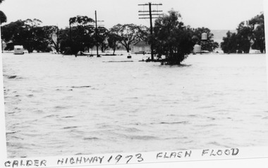
Photograph, B/W photograph 1973 Flash Flood on Calder Highway
... B/W photograph 1973 Flash Flood on Calder Highway...1973 Flash Flood on Calder Highway...Unframed B/W photograph 1973 Flash Flood on Calder Highway...Flood Calder Highway, Flash flood...Charlton Golden Grains Museum Inc 1 High Street Charlton goldfields 1973 Flash Flood on Calder Highway Charlton Calder Highway Floods Flood Calder Highway, Flash flood Unframed B/W photograph 1973 Flash Flood on Calder Highway B/W photograph 1973 Flash Flood on Calder Highway Photograph Photograph ...1973 Flash Flood on Calder HighwayUnframed B/W photograph 1973 Flash Flood on Calder HighwayFlood Calder Highway, Flash floodcharlton, calder highway, floods -
 Kew Historical Society Inc
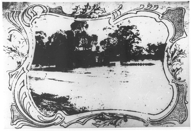
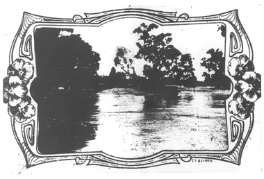
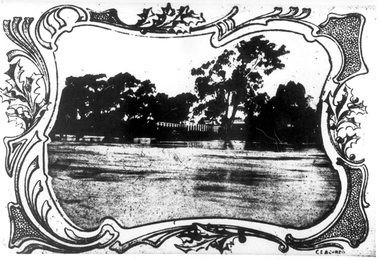
Photograph, Marnie McLeod, Flood, River Yarra, Kew, 1916
... Flood, River Yarra, Kew...Laver's private residence fortunately is high above flood level, but two houses he owns off Young-street have been flooded out. ...Small black and white photograph of flooded trees in Kew....Inscription on reverse in ink "Flood R. Yarra Kew Vic...Together with our original MMBW River Yarra map showing flood levels, these items, when compared allow researchers to gain a visual perspective of the extent of the flood in 1916. river yarra kew floods 1916 Inscription on reverse in ink "Flood R. ...The donation was accompanied by the following letter from the donor: "Hi. I found these in with family photos. Taken by family as Mamie McLeod was living in Fellows Street, Kew, so would be near there. Retain (or discard) as you see fit." [Donor's name and address withheld from public view]. To gain an insight into the flood levels at Kew, it is worth reading newspaper accounts of the event. The Age published an article - Valuable Gardens Destroyed at Kew - on 25 September 1916: "VALUABLE GARDENS DESTROYED AT KEW. From the heights of Studley Park, Kew, a splendid view of the flood waters can be obtained, and yesterday afternoon, despite continuous rain, crowds of citizens assembled there to witness the spectacle. There is a vast stretch of water some 300 or 400 yards broad, above the foot bridge connecting Gipps-street, Collingwood, and Studley Park. The river is only about 3 feet from the top of the embankment connecting with the ramp of the bridge on the Studiey Park side. When the upper llood waters come down it is almost a certainty that tne embankment will be submerged and the bridge rendered impassible. Below the bridge the waters again stretch out, and have submerged all the low-lying land on the Collingwood side and invaded the back premises ot the Kodak Co., Phoenix Biscuit Factory, a tannery adjoining thereto, the Shamrock Brewery, and Chinese gardens in the vicinity. At Walmer-street-bridge, at the end of Studley Park, the low-lying land on the Kew side is covered with water to the depth of many feet. Tlie land in question is owned in a great part by Mr Frank Lavers who haa gone in for intense culture on a pretty liberal scale on both the slopes of the hill and on the river flat. On the latter he is cultivating many acres of asparagus, and has at a considerable cost spent three years in preparing the ground and installing an irrigation system, reticulated from the Yan Yean water supply. This year the asparagus was put down, and the plants were in a promising condition. Tlie flood waters are now flowing fast over the land. The crop is ruined, and three years' work and expenditure destroyed. Mr. Laver's private residence fortunately is high above flood level, but two houses he owns off Young-street have been flooded out. Having been warned in time, the tenants removed their furniture hefore the water came down to Mr. Laver's residence, where they themselves have been given accommodation in the meantime. All the river flats in East Kew are under water. One or two low-lying houses have been flooded. Chipperfield's boat shed at Willsmere is nearly covered, and some Chinese gardens in the vicinity are several feet under water."This, and the other three photographs donated of floods in Kew are believed to be the earliest in the collection. Together with our original MMBW River Yarra map showing flood levels, these items, when compared allow researchers to gain a visual perspective of the extent of the flood in 1916. Small black and white photograph of flooded trees in Kew.Inscription on reverse in ink "Flood R. Yarra Kew Vicriver yarra, kew, floods 1916 -
 Sunbury Family History and Heritage Society Inc.
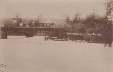
Postcard, Jackson Creek in flood Sunbury
... Jackson Creek in flood Sunbury...The post card is a record of a time when the Jacksons Creek flooded and the water almost reached the two arches on the Macedon Street Bridge. ...A non digital sepia photograph in post card format of a river in flood with the water almost reaching the two arches on the stone bridge. ...JACKSON CREEK IN FLOOD SUNBURY...Macedon Street bridge Jacksons Creek Goonawarra Winery JACKSON CREEK IN FLOOD SUNBURY A non digital sepia photograph in post card format of a river in flood with the water almost reaching the two arches on the stone bridge. ...The post card is a record of a time when the Jacksons Creek flooded and the water almost reached the two arches on the Macedon Street Bridge. The Goonawarra Winery buildings can be seen in the back ground.A non digital sepia photograph in post card format of a river in flood with the water almost reaching the two arches on the stone bridge. Farm buildings can be seen in the middle distance.JACKSON CREEK IN FLOOD SUNBURYmacedon street bridge, jacksons creek, goonawarra winery -
 Ringwood and District Historical Society
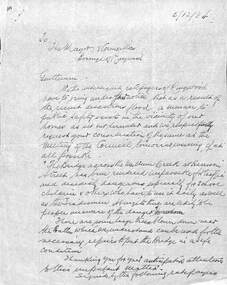
Document, Council flood relief for Mullum Creek flood in Ringwood in 1934
... Council flood relief for Mullum Creek flood in Ringwood in 1934...Hand written letters to Ringwood Council re flood relief....Correspondence to Council from Ratepayers asking for flood relief resulting from the flood damage in the vicinity of Harrison Street bridge over Mullum Creek in 1934....Hand written letters to Ringwood Council re flood relief. Council flood relief for Mullum Creek flood in Ringwood in 1934 Document ...Hand written letters to Ringwood Council re flood relief.Correspondence to Council from Ratepayers asking for flood relief resulting from the flood damage in the vicinity of Harrison Street bridge over Mullum Creek in 1934. -
 Charlton Golden Grains Museum Inc
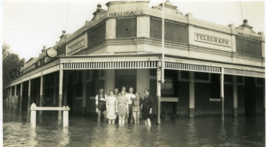
Photograph - Telegraph Hotel in 1939 flood, 1939
... Telegraph Hotel in 1939 flood....Telegraph Hotel in 1939 flood. The river level reached 8.25 metres in April....Black & white photograph of Halligan's Telegraph Hotel in 1939 flood. Corner of Armstrong & Camp Streets. ...Avoca Rover flood Easter 1939. Donated by Mrs T Loughnan....Hotels Halligan Telegraph Hotel Business Armstrong Street Charlton Floods Avoca Rover flood Easter 1939. Donated by Mrs T Loughnan. ...Telegraph Hotel in 1939 flood. The river level reached 8.25 metres in April.Black & white photograph of Halligan's Telegraph Hotel in 1939 flood. Corner of Armstrong & Camp Streets. Halligans & staff including Tess Maher (Loughnan) standing in front of hotelAvoca Rover flood Easter 1939. Donated by Mrs T Loughnan.hotels, halligan, telegraph hotel, business, armstrong street, charlton, floods -
 University of Melbourne, Burnley Campus Archives
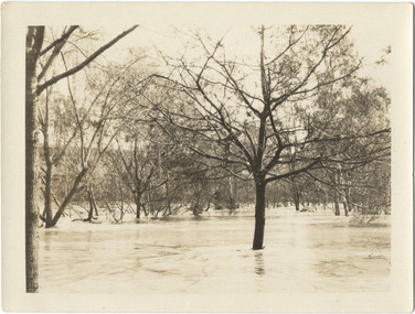
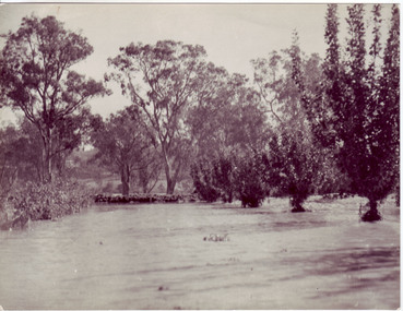
Photograph - Black and white print, Orchard in Flood, 1934
... Orchard in Flood...Black and white photograph. Orchard in flood...On reverse, "Orchard Yarra River in flood Dec 1934."...University of Melbourne, Burnley Campus Archives 500 Yarra Boulevard Richmond melbourne orchard yarra river floods 1934 On reverse, "Orchard Yarra River in flood Dec 1934." ...Black and white photograph. Orchard in floodOn reverse, "Orchard Yarra River in flood Dec 1934."orchard, yarra river, floods, 1934 -
 University of Melbourne, Burnley Campus Archives
Photograph - Black and white print, Orchard in Flood, 1934
... Orchard in Flood...Black and white photograph. Orchard in flood...On reverse, "Orchard Yarra River in flood Dec 1934."...University of Melbourne, Burnley Campus Archives 500 Yarra Boulevard Richmond melbourne orchard yarra river floods 1934 On reverse, "Orchard Yarra River in flood Dec 1934." ...Black and white photograph. Orchard in floodOn reverse, "Orchard Yarra River in flood Dec 1934."orchard, yarra river, floods, 1934 -
 Greensborough Historical Society
Booklet, H. H. Paynting, The James Flood book of early Melbourne, 1967
... The James Flood book of early Melbourne......James Flood Charity Trust...H. Paynting James Flood Charity Trust ...Collection of photographs of 19th and early 20th century Melbourne.35 p. black and white illustrationsmelbourne, james flood -
 University of Melbourne, Burnley Campus Archives
Photograph - Black and white print, Orchard in Flood, 1934
... Orchard in Flood...Black and white photograph. Orchard in flood. Seedlings planted in rows....On reverse, "Orchard Yarra River in flood Dec 1934."...University of Melbourne, Burnley Campus Archives 500 Yarra Boulevard Richmond melbourne orchard yarra river floods 1934 On reverse, "Orchard Yarra River in flood Dec 1934." ...Black and white photograph. Orchard in flood. Seedlings planted in rows.On reverse, "Orchard Yarra River in flood Dec 1934."orchard, yarra river, floods, 1934 -
 University of Melbourne, Burnley Campus Archives
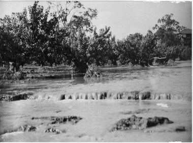
Photograph - Black and white print, Orchard After Flood, 1934
... Orchard After Flood...Black and white photograph. Orchard after flood: shows soil washed away.... On reverse, "Orchard after flood Dec 1934."...University of Melbourne, Burnley Campus Archives 500 Yarra Boulevard Richmond melbourne orchard yarra river floods 1934 damage On reverse, "Orchard after flood Dec 1934." ...Black and white photograph. Orchard after flood: shows soil washed away. On reverse, "Orchard after flood Dec 1934."orchard, yarra river, floods, 1934, damage -
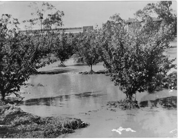 University of Melbourne, Burnley Campus Archives
Photograph - Black and white print, Orchard in Flood, 1934
... Orchard in Flood...Black and white photograph. Orchard in flood: shows fruit trees standing in water....On reverse, "Orchard Yarra River in flood Dec 1934."...University of Melbourne, Burnley Campus Archives 500 Yarra Boulevard Richmond melbourne orchard yarra river floods 1934 fruit trees On reverse, "Orchard Yarra River in flood Dec 1934." ...Black and white photograph. Orchard in flood: shows fruit trees standing in water.On reverse, "Orchard Yarra River in flood Dec 1934."orchard, yarra river, floods, 1934, fruit trees -
 Charlton Golden Grains Museum Inc
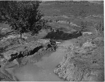
Photograph, Cameron, Ian, 1973 Flood W. Fitzpatrick's House on Calder Highway, Feb 1973
... 1973 Flood W. Fitzpatrick's House on Calder Highway...1973 flood. W. Fitzpatrick's house on Calder Hwy, surrounded by flood water from Yeungroon Creek....B/W photograph of 1973 flood. W Fitzpatrick's house on Calder Highway surrounded by flood water from flooded Yeungroon Creek....Charlton Calder Highway Yeungroon Floods B/W photograph of 1973 flood. W Fitzpatrick's house on Calder Highway surrounded by flood water from flooded Yeungroon Creek. 1973 Flood W. ...1973 flood. W. Fitzpatrick's house on Calder Hwy, surrounded by flood water from Yeungroon Creek.B/W photograph of 1973 flood. W Fitzpatrick's house on Calder Highway surrounded by flood water from flooded Yeungroon Creek.charlton, calder highway, yeungroon, floods -
 University of Melbourne, Burnley Campus Archives
Photograph - Black and white print, Orchard After Flood, 1934
... Orchard After Flood...Orchard after flood: shows soil washed away from roots around fruit tree...On reverse, "Orchard after flood Dec 1934."...University of Melbourne, Burnley Campus Archives 500 Yarra Boulevard Richmond melbourne orchard yarra river floods 1934 fruit tree damage to roots On reverse, "Orchard after flood Dec 1934." ...Orchard after flood: shows soil washed away from roots around fruit treeOn reverse, "Orchard after flood Dec 1934."orchard, yarra river, floods, 1934, fruit tree, damage to roots -
 Tarnagulla History Archive
Photograph: Debris after flood, Newbridge, Debris after flood, Newbridge, 1909 (original image)
... Debris after flood, Newbridge ......flood...At Newbridge, Petersen's bakery collapsed and Simpson's Store and Hotel flooded to the roof. The billiard table was later found in a tree five miles down the Loddon near Learmonth. ...Monochrome photograph, image depicting debris in the area near Loddon River at Newbridge after major flood in 1909. This is a very dark copy of an older original. ...Copy probably made by Murray Comrie in the 1960s. Debris after flood, Newbridge Photograph: Debris after flood, Newbridge ...On 20th August, 1909 the Laanecoorie Weir broke away and released 18.3 million cubic metres of water through the opening and causing severe damage to all towns downstream. At Newbridge, Petersen's bakery collapsed and Simpson's Store and Hotel flooded to the roof. The billiard table was later found in a tree five miles down the Loddon near Learmonth. Murray Comrie Collection. Monochrome photograph, image depicting debris in the area near Loddon River at Newbridge after major flood in 1909. This is a very dark copy of an older original. Copy probably made by Murray Comrie in the 1960s.newbridge, loddon river, flood -
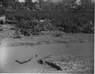
 Charlton Golden Grains Museum Inc
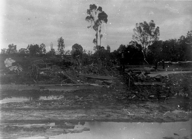
Photograph, Charlton Tribune, Flood Water damage to McGurk's fence, c. 1980
... Flood Water damage to McGurk's fence...Flood 1971, damage to Mc Gurk's fencing on Calder Highway....B/W photo of flood water & damage to McGurk's fence on Calder Highway in 1971 flood....Calder Highway Charlton Floods B/W photo of flood water & damage to McGurk's fence on Calder Highway in 1971 flood. ...Flood 1971, damage to Mc Gurk's fencing on Calder Highway.B/W photo of flood water & damage to McGurk's fence on Calder Highway in 1971 flood.calder highway, charlton, floods -
 Clunes Museum
Ephemera - DVD, IMAGES OF CLUNES FLOOD 2010
... IMAGES OF CLUNES FLOOD 2010....1 CD photographs of the Clunes floods 4/9/2010 .2 CD Case...handwritten on inside of case: Clunes floods 4/9/2010. Lyndsey Iles, Lathlain Street...Clunes Museum 36 Fraser Street enter building through Collins Place Clunes goldfields floods compact disk handwritten on inside of case: Clunes floods 4/9/2010. ....1 CD photographs of the Clunes floods 4/9/2010 .2 CD Casehandwritten on inside of case: Clunes floods 4/9/2010. Lyndsey Iles, Lathlain Streetfloods, compact disk -
 Tarnagulla History Archive
Photograph: Simpsons Store and Hotel, Newbridge after flood, Simpsons Store and Hotel, Newbridge after flood, 1909 (original image)
... Simpsons Store and Hotel, Newbridge after flood......flood...At Newbridge, Petersen's bakery collapsed and Simpson's Store and Hotel flooded to the roof. The billiard table was later found in a tree five miles down the Loddon near Learmonth. ...Monochrome photograph, image depicting buildings in the area near Loddon River at Newbridge after major flood in 1909. This is a very grainy and dark copy of an older original. ...Simpsons Store and Hotel, Newbridge after flood Photograph: Simpsons Store and Hotel, Newbridge after flood ...In this image, store merchandise, including drapery, is hung out to dry after the flood. On 20th August,1909 the Laanecoorie Weir broke away and released 18.3 million cubic metres of water through the opening and causing severe damage to all towns downstream. At Newbridge, Petersen's bakery collapsed and Simpson's Store and Hotel flooded to the roof. The billiard table was later found in a tree five miles down the Loddon near Learmonth. Murray Comrie Collection. Monochrome photograph, image depicting buildings in the area near Loddon River at Newbridge after major flood in 1909. This is a very grainy and dark copy of an older original. Copy probably made by Murray Comrie in the 1960s.newbridge, loddon river, flood, simpson, stores, hotels -
 Tarnagulla History Archive
Photographs: Loddon River, Newbridge after flood, Loddon River, Newbridge after flood, 1909 (original image)
... Loddon River, Newbridge after flood......flood...At Newbridge, Petersen's bakery collapsed and Simpson's Store and Hotel flooded to the roof. The billiard table was later found in a tree five miles down the Loddon near Learmonth. ...Two copies of a monochrome photograph, image depicts the area near Loddon River at Newbridge after major flood in 1909. This is a very grainy and dark copy of an older original. ...Loddon River, Newbridge after flood Photographs: Loddon River, Newbridge after flood ...On 20th August,1909 the Laanecoorie Weir broke away and released 18.3 million cubic metres of water through the opening and causing severe damage to all towns downstream. At Newbridge, Petersen's bakery collapsed and Simpson's Store and Hotel flooded to the roof. The billiard table was later found in a tree five miles down the Loddon near Learmonth. Murray Comrie Collection. Two copies of a monochrome photograph, image depicts the area near Loddon River at Newbridge after major flood in 1909. This is a very grainy and dark copy of an older original. Copy probably made by Murray Comrie in the 1960s.newbridge, loddon river, flood, bridge -
 Tarnagulla History Archive
Photographs: Loddon River, Newbridge after flood, Loddon River, Newbridge after flood, 1909 (original image)
... Loddon River, Newbridge after flood......flood...At Newbridge, Petersen's bakery collapsed and Simpson's Store and Hotel flooded to the roof. The billiard table was later found in a tree five miles down the Loddon near Learmonth. ...Two copies of a monochrome photograph, image part of damaged bridge in the area near Loddon River at Newbridge after major flood in 1909. This is a very grainy and dark copy of an older original. ...Loddon River, Newbridge after flood Photographs: Loddon River, Newbridge after flood ...On 20th August,1909 the Laanecoorie Weir broke away and released 18.3 million cubic metres of water through the opening and causing severe damage to all towns downstream. At Newbridge, Petersen's bakery collapsed and Simpson's Store and Hotel flooded to the roof. The billiard table was later found in a tree five miles down the Loddon near Learmonth. Murray Comrie Collection. Two copies of a monochrome photograph, image part of damaged bridge in the area near Loddon River at Newbridge after major flood in 1909. This is a very grainy and dark copy of an older original. Copy probably made by Murray Comrie in the 1960s.newbridge, loddon river, flood, bridge -
 Ballarat Heritage Services
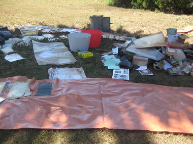
Photograph - Colour, Flood recovery, Carisbrook, 40 degree heat
... Flood recovery, Carisbrook, 40 degree heat......flood...Colour photographs of paperbased items being 'recovered' after the Carisbrook floods....Ballarat Heritage Services PO Box 2209 Bakery Hill Post Office goldfields carisbrook flood flood recovery Colour photographs of paperbased items being 'recovered' after the Carisbrook floods. ...Colour photographs of paperbased items being 'recovered' after the Carisbrook floods.carisbrook, flood, flood recovery -
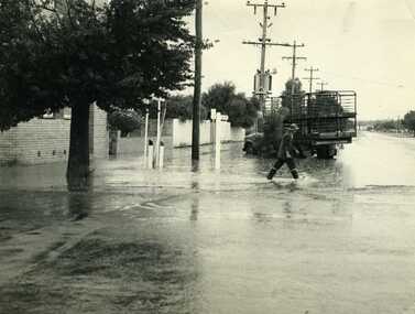 Charlton Golden Grains Museum Inc
Photograph, Cameron, Ian, 1972 Flash Flood, Jan 1972
... 1972 Flash Flood...1972 Flash flood, cnr of High St and Armstrong St, Charlton....Man crossing road through flood water....Charlton Armstrong Street Floods B/W photograph of 1972 flash flood Corner High Street & Armstrong Streets. ...1972 Flash flood, cnr of High St and Armstrong St, Charlton.B/W photograph of 1972 flash flood Corner High Street & Armstrong Streets. Man crossing road through flood water.charlton, armstrong street, floods -
 Melbourne Tram Museum
Photograph - Set of 11 Black and White photograph, Ken Flood, 18/04/1974 12:00:00 AM
... Set of 11 black and white photographs sent to Keith Kings received from Ken Flood 4/6/1975. .1 - Bus No 203 1940 Leyland TD5c - Turning from Nicholson Street into Gertrude Street. - bound for Northcote. .2 - Bus No 201 1940 Leyland TD5c - In Nicholson Street at Albert Street - Photo. bound for Northcote .3.- Bus No 492 1943 Ford Austerity - at Queens Pde Clifton Hill - Note the Pram and Passenger bus sign by the front doorway. ...On rear of the photos in ink; .1 - MMTB 203 9/6/49 - K Flood .2 - MMTB 201 - 9/6/49 - K Flood .3 - MMTB Ford #492 - K Flood .4 - MMTB #365 - K Flood .5 - MMTB #325 - K Flood .6 - MMTB #500 Pt Ormond 6/6/49 - K Flood .7 - MMTB #19 9/6/49 - K Flood .8 - MMTB #143 - K Flood .9 - MMTB #4 9/6/49, K Flood .10 - MMTB #4 9/6/49, K Flood .11 - MMTB #150 - K Flood...Ken Flood...Melbourne Tram Museum 8 Wallen Road Hawthorn melbourne Trams tramways Buses Double Deck Buses Prams MMTB Buses Austerity buses W2 class tram 305 Bus 203 bus 201 bus 492 bus 365 bus 500 bus 19 bus 143 bus 9 bus 4 bus 150 Leyland Ford Motor Company TD5c class OPS1 class OPS4 class TS8c class Cub class TS11c class On rear of the photos in ink; .1 - MMTB 203 9/6/49 - K Flood .2 - MMTB 201 - 9/6/49 - K Flood .3 - MMTB Ford #492 - K Flood .4 - MMTB #365 - K Flood .5 - MMTB #325 - K Flood .6 - MMTB #500 Pt Ormond 6/6/49 - K Flood .7 - MMTB #19 9/6/49 - K Flood .8 - MMTB #143 - K Flood .9 - MMTB #4 9/6/49, K Flood .10 - MMTB #4 9/6/49, K Flood .11 - MMTB #150 - K Flood Set of 11 black and white photographs sent to Keith Kings received from Ken Flood 4/6/1975. .1 - Bus No 203 1940 Leyland TD5c - Turning from Nicholson Street into Gertrude Street. - bound for Northcote. .2 - Bus No 201 1940 Leyland TD5c - In Nicholson Street at Albert Street - Photo. bound for Northcote .3.- Bus No 492 1943 Ford Austerity - at Queens Pde Clifton Hill - Note the Pram and Passenger bus sign by the front doorway. ...Set of 11 black and white photographs sent to Keith Kings received from Ken Flood 4/6/1975. .1 - Bus No 203 1940 Leyland TD5c - Turning from Nicholson Street into Gertrude Street. - bound for Northcote. .2 - Bus No 201 1940 Leyland TD5c - In Nicholson Street at Albert Street - Photo. bound for Northcote .3.- Bus No 492 1943 Ford Austerity - at Queens Pde Clifton Hill - Note the Pram and Passenger bus sign by the front doorway. Photo not dated. .4 - Bus No 365 1948 OPS1 - Nicholson Street at Victoria Pde. bound for East Brunswick. Photo not dated. .5 - Bus No 325 1950 OPS4 - Nicholson Street at Victoria Pde. bound for East Brunswick. Photo not dated. Bus did not enter service until 1950. .6 - Bus No 500 1943 Ford Austerity - Marine Pde. Point Ormond. Note the Pram bus sign by the front door. .7 - Bus No 19 1938 Leyland Cub (diesel) with Preston Workshops body. - Lonsdale Street at William Street. W2 No 305 passes behind the bus. Late 1940's photo. .8 - Bus No 143 1940 Leyland TS8c drop enter - in Russell Street at LaTrobe Street bound for North Kew. (Belford Road via Collingwood). Photo not dated. .9 - Bus No 9 1938 Leyland Cub (diesel) with Preston Workshops body. - in Russell Street at LaTrobe Street bound for North Carlton .10 - Bus No 4 1938 Leyland Cub (Diesel) with Preston Workshops body - in Lonsdale Street at William Street. note destination not reset for the return trip. .11 - Bus No 150 1940 Leyland TS11c Drop enter - Nicholson Street at Victoria Pde. Photo not dated. Most of the photos dated 9/6/1949 unless noted otherwise. Notes on photos provided by Rod Atkins - see htd5860doc.pdfOn rear of the photos in ink; .1 - MMTB 203 9/6/49 - K Flood .2 - MMTB 201 - 9/6/49 - K Flood .3 - MMTB Ford #492 - K Flood .4 - MMTB #365 - K Flood .5 - MMTB #325 - K Flood .6 - MMTB #500 Pt Ormond 6/6/49 - K Flood .7 - MMTB #19 9/6/49 - K Flood .8 - MMTB #143 - K Flood .9 - MMTB #4 9/6/49, K Flood .10 - MMTB #4 9/6/49, K Flood .11 - MMTB #150 - K Floodtrams, tramways, buses, double deck buses, prams, mmtb buses, austerity buses, w2 class, tram 305, bus 203, bus 201, bus 492, bus 365, bus 500, bus 19, bus 143, bus 9, bus 4, bus 150, leyland, ford motor company, td5c class, ops1 class, ops4 class, ts8c class, cub class, ts11c class -
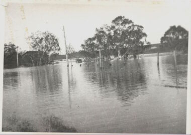 Kew Historical Society Inc
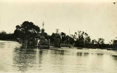
Photograph, Willsmere Bridge, 1934
... ...flood...The Moorings was almost washed away in the 1916 floods, and in 1934 almost totally submerged when the Yarra River rose 26 feet in 14 hours. ...A view of flooded areas in North Kew in the flood of 1934....Chipperfields. 1934 flood...Chipperfields. 1934 flood A view of flooded areas in North Kew in the flood of 1934. ...Several boathouses were built in Kew and Fairfield in the late 19th and early 20th centuries. They included Chipperfield’s ‘Moorings’ and floating pontoon. The substantial two-storey house was named the Moorings, and incorporated an upper storey residence. The Moorings was almost washed away in the 1916 floods, and in 1934 almost totally submerged when the Yarra River rose 26 feet in 14 hours. Following the 1934 flood, the house was restored. The floating pontoon, sometimes referred to as a ‘kiosk’ or ‘canteen’, was used to store canoes. Both were removed in 1972 for the construction of the Eastern Freeway.This work forms part of the collection assembled by the historian Dorothy Rogers, that was donated to the Kew Historical Society by her son John Rogers in 2015. The manuscripts, photographs, maps, and documents were sourced by her from both family and local collections or produced as references for her print publications. Many were directly used by Rogers in writing ‘Lovely Old Homes of Kew’ (1961) and 'A History of Kew' (1973), or the numerous articles on local history that she produced for suburban newspapers. Most of the photographs in the collection include detailed annotations in her hand. The Rogers Collection provides a comprehensive insight into the working habits of a historian in the 1960s and 1970s. Together it forms the largest privately-donated collection within the archives of the Kew Historical Society.A view of flooded areas in North Kew in the flood of 1934.Willsmere Bridge. Chipperfields. 1934 floodwillsmere, flood, yarra flood, chipperfields, chipperfields boathouse, north kew -
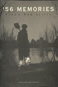 Sunshine and District Historical Society Incorporated
Book - '56 Memories Flood Red Cliffs, Mary Chandler et al, C1964
... '56 Memories Flood Red Cliffs...In 1956, the Murray River flooded, affecting many towns along its' banks. ...'56 Memories Flood Red Cliffs...In 1956, the Murray River flooded, affecting many towns along its' banks. ...In 1956, the Murray River flooded, affecting many towns along its' banks. It was one of the biggest floods on record and the worst experienced in the area in the 20th century. The book details the historical impact to infrastructure, agriculture and community action along with personal experiences of residents affected. '56 Memories Flood Red Cliffsred cliffs, floods -
 Charlton Golden Grains Museum Inc
Photograph, War Memorial 1933 Flood
... War Memorial 1933 Flood...1933 Flood, War Memorial Charlton with Mechanics Institute behind....War Memorial 1933 flood with Mechanics Institute in background...Charlton Mechanics Institure War Memorial Floods War Memorial 1933 flood with Mechanics Institute in background War Memorial 1933 Flood Photograph Photograph ...1933 Flood, War Memorial Charlton with Mechanics Institute behind.War Memorial 1933 flood with Mechanics Institute in backgroundcharlton, mechanics institure, war memorial, floods -
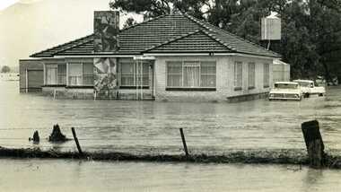
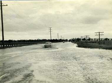 Charlton Golden Grains Museum Inc
Photograph, Charlton Tribune, 1973 Flood, Nov 1971
... 1973 Flood...1971 flood, Car driving through flood water on Calder Highway, Charlton, Victoria...B/W photograph of 1971 flood. Car driving through floodwater on Calder Highway....Charlton Golden Grains Museum Inc 1 High Street Charlton goldfields 1971 flood, Car driving through flood water on Calder Highway, Charlton, Victoria Calder Highway Floods B/W photograph of 1971 flood. ...1971 flood, Car driving through flood water on Calder Highway, Charlton, VictoriaB/W photograph of 1971 flood. Car driving through floodwater on Calder Highway.calder highway, floods -
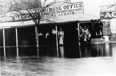 Charlton Golden Grains Museum Inc
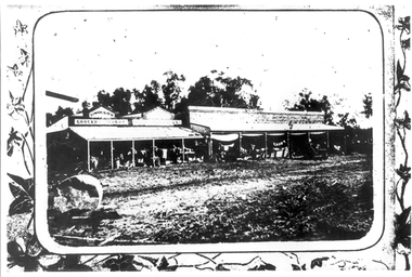
Photograph, Flood High Street Charlton outside Tribune Office
... Flood High Street Charlton outside Tribune Office...Flood in High Street Charlton. People standing in front of Charlton Tribune Office....Flood High Street Charlton outside Tribune Office...Charlton Tribune Charlton Floods Flood High Street Charlton outside Tribune Office Flood High Street Charlton outside Tribune Office Photograph Photograph ...Flood in High Street Charlton. People standing in front of Charlton Tribune Office.Flood High Street Charlton outside Tribune Officecharlton tribune, charlton, floods -
 Charlton Golden Grains Museum Inc
Photograph, Charlton Tribune, 1973 flood at low water bridge
... 1973 flood at low water bridge...1973 Flood at Charlton, Vic. At the low water bridge....Unframed photograph/ sepia of 1973 flooding of Charlton at low water bridge....Low water bridge Floods Unframed photograph/ sepia of 1973 flooding of Charlton at low water bridge. 1973 flood at low water bridge Photograph Photograph Charlton Tribune Cameron, Ian ...1973 Flood at Charlton, Vic. At the low water bridge.Unframed photograph/ sepia of 1973 flooding of Charlton at low water bridge.low water bridge, floods -
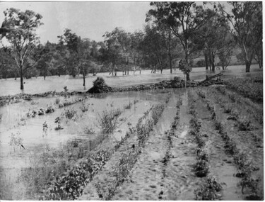
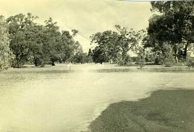
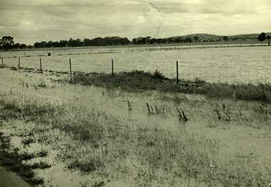 Charlton Golden Grains Museum Inc
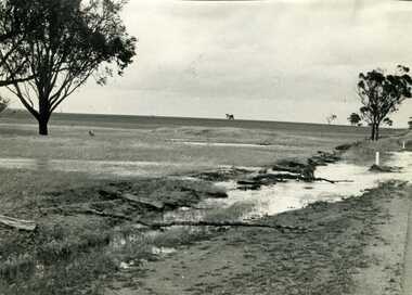
Photograph, Charlton Tribune, B/W photograph of 1971 flood, Nov 1971
... B/W photograph of 1971 flood...1971 flood at Charlton. Paddocks and roadside along Calder Highway....Unframed photograph of 1971 flood. Paddocks and roadside along Calder Highway....Charlton Calder Highway Floods Unframed photograph of 1971 flood. Paddocks and roadside along Calder Highway. ...1971 flood at Charlton. Paddocks and roadside along Calder Highway.Unframed photograph of 1971 flood. Paddocks and roadside along Calder Highway.charlton, calder highway, floods