Showing 69 items matching " garden allotments"
-
 Bendigo Historical Society Inc.
Map - LOCKWOOD, November 25th 1855
... ... Garden Allotments...Map: Garden Allotments within the Town Reserve of Lockwood on the Bullock Creek. ...History House 11 Mackenzie Street Bendigo goldfields MAP Bendigo parish plan Lockwood Garden Allotments Bullock creek Map: Garden Allotments within the Town Reserve of Lockwood on the Bullock Creek. ...Map: Garden Allotments within the Town Reserve of Lockwood on the Bullock Creek. Parish plan (number 273 in map cupboard 1)map, bendigo, parish plan, lockwood, garden allotments, bullock creek -
University of Melbourne, Burnley Campus Archives
Book, Royal Horticultural Society, The Vegetable Garden Displayed, 1959
... Very detailed descriptions of how to plant out gardens or allotments. Individual vegetables described. ...allotments wisley Book with light cardboard cover. Produced by the Royal Horticultural Society, London. Eleventh Impression 365th thousand, 1949. Very detailed descriptions of how to plant out gardens ...Book with light cardboard cover. Produced by the Royal Horticultural Society, London. Eleventh Impression 365th thousand, 1949. Very detailed descriptions of how to plant out gardens or allotments. Individual vegetables described. Photographs from Wisley, Surrey.vegetables, vegetable growing, home gardening, royal horticultural society, allotments, wisley -
 City of Moorabbin Historical Society (Operating the Box Cottage Museum)
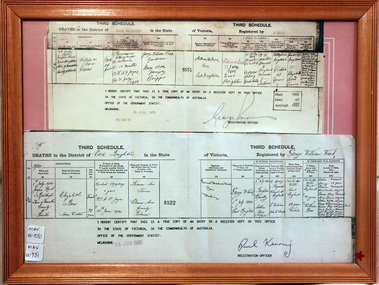
Document, Death Certificate William Box 1902, 1985
... William Box with his wife Elizabeth Avis Box at first leased market garden allotments in Brighton that was part of the Henry Dendy Special Survey 1841. ...William Box with his wife Elizabeth Avis Box at first leased market garden allotments in Brighton that was part of the Henry Dendy Special Survey 1841. ...William Box1834-1902 and Elizabeth Avis Box 1835-1913 came to Australia with his parents George and Mary Cripps-Box and siblings in 1856. Caroline Box, the eldest daughter of George and Mary Cripps-Box, remained in England working as a cook until she joined the family in Australia in 1863. William Box with his wife Elizabeth Avis Box at first leased market garden allotments in Brighton that was part of the Henry Dendy Special Survey 1841. In 1868 and 1869 they purchased 2 blocks with a pioneer’s cottage in Jasper Road East Brighton ( now Ormond / McKinnon ) where they established a market garden, built a 2nd house and raised 13 children. In 1908 Elizabeth sold most of the land retaining 1 acre with the dwellings in which she resided with her two daughters until her death 1913. The original pioneer cottage was reconstructed in 1984 and is known as Box Cottage Museum William & Elizabeth Avis- Box settled in the pioneer Cottage in Jasper Road East Brighton 1868 and established a market garden whilst raising their 13 children. This Cottage was reconstructed in Joyce Park, Ormond 1984 and is the home of City of Moorabbin Historical Society. In 1960 many local residents responded to a call for the donation of historical artefacts and the Box Cottage Museum now preserves this eclectic collection for the community. A certified true copy of the Death Certificate of William Box 1834 -1902 in a wooden picture frame, obtained from The Births, Deaths and Marriages Office Melbourne Victoria 1985 THIRD SCHEDULE / DEATHS in the District of East Brighton in the State of Victoria Registered by W. Ward Certified ‘true copy of an entry in a register’……… Signed by Paul Kenny Registration Officer 1985 box william, box elizabeth, brighton, moorabbin, cottages, pioneers, ormond, colonial, mckinnon, dendy henry, museums, box alonzo, market gardeners, box cottage museum -
 Kew Historical Society Inc
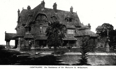
Photograph, 'Goathland', The Residence of Sir Malcolm D McEacharn, 1901-1911
... The house was demolished in 1960, despite opposition from the National Trust (Victoria), and its gardens subdivided into residential allotments....The house was demolished in 1960, despite opposition from the National Trust (Victoria), and its gardens subdivided into residential allotments. byram goathland tara hall lowan studley park road -- kew (vic.) melbourne mansions e g kilburn - architect "'Goathland', The Residence of Sir Malcolm D McEacharn" An early photograph of Goathland (also known as Byram, Lowan and Tara Hall). ...The architect, Edward Kilburn designed Byram in the Arts & Crafts style for the industrialist George Ramsden. Construction began in 1888 and was reputed to have lasted three years. The mansion had frontages to Studley Park Road and Stevenson Street, including gardens laid out with great taste, including pleasure grounds, tennis lawn, fruit and flower garden, and paddock.The size of many of the trees in the garden indicate that many survived from the garden of Clifton Villa, the previous single-storeyed house built on the site by the Stevenson brothers. Byram had views to Melbourne and Port Phillip Bay. The house was demolished in 1960, despite opposition from the National Trust (Victoria), and its gardens subdivided into residential allotments.An early photograph of Goathland (also known as Byram, Lowan and Tara Hall). The photo shows the front of the building during the period of Sir Malcolm McEacharn’s occupation of the house (1901-11). Edward George Kilburn, of Ellerker & Kilburn, had originally designed the house for the industrialist George Ramsden in 1888. When Sir Malcolm McEacharn purchased Byram, he was to rename it as Goathland. This has led to some confusion, as Goathland was also the name used for McEacharn’s other home in St. Kilda. The period of McEacharn’s ownership represented the high point of the mansion’s history. 'Lost Glories: a memorial to forgotten Australian buildings' was published by David Latta in 1986. It tells the story of a number of significant Australian buildings that had previously been demolished. A chapter in the book was devoted to Goathland, later known as Tara Hall. To supplement the text, he sourced photographs from a range of suppliers, chiefly the Royal Women's Hospital which had once owned Tara Hall, but had sold it in 1960. This is one of the photographs donated to KHS by the author."'Goathland', The Residence of Sir Malcolm D McEacharn"byram, goathland, tara hall, lowan, studley park road -- kew (vic.), melbourne mansions, e g kilburn - architect -
 Bendigo Historical Society Inc.
Slide - No 10 Valentine Street Bendigo
... Set amongst a private garden on a corner allotment of approx. 827m2, the residence includes entrance hall, ornate formal Lounge Room, spacious renovated kitchen and family room, 4 Bedrooms plus a music room or office, Bathroom plus provision for 2nd bathroom or ensuite off the main Bedroom. ...Set amongst a private garden on a corner allotment of approx. 827m2, the residence includes entrance hall, ornate formal Lounge Room, spacious renovated kitchen and family room, 4 Bedrooms plus a music room or office, Bathroom plus provision for 2nd bathroom or ensuite off the main Bedroom. ...Situated walking distance from the city centre just off View Street is this superbly restored Victorian Residence displaying ornate treatment & style given to the house in 1880 by Bendigos famous architect William C. Vahland. Set amongst a private garden on a corner allotment of approx. 827m2, the residence includes entrance hall, ornate formal Lounge Room, spacious renovated kitchen and family room, 4 Bedrooms plus a music room or office, Bathroom plus provision for 2nd bathroom or ensuite off the main Bedroom. Large laundry, 2 toilets, downstairs includes large workshop, cellar and storage. Superb front & rear verandahs and private paved rear garden with double carport. The home is in excellent condition with loads of taste, style quality and charm. No 10 Valentine Street Bendigo - Slidehistory, bendigo, national trust collection bendigo, 10 valentine street -
 Kew Historical Society Inc
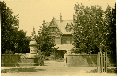
Photograph, J F C Farquhar, A View in Studley Park Road, 1891
... The house was demolished in 1960, despite opposition from the National Trust (Victoria), and its gardens subdivided into residential allotments....The house was demolished in 1960, despite opposition from the National Trust (Victoria), and its gardens subdivided into residential allotments. A View in Studley Park Road Photograph J F C Farquhar ...At the beginning of the 1890s, the Kew businessman and Town Councillor, Henry Kellett, commissioned J.F.C. Farquhar to photograph scenes of Kew. These scenes included panoramas as well as pastoral scenes. The resulting set of twelve photographs was assembled in an album, Kew Where We Live, from which customers could select images for purchase.The preamble to the album describes that the photographs used the ‘argentic bromide’ process, now more commonly known as the gelatine silver process. This form of dry plate photography allowed for the negatives to be kept for weeks before processing, hence its value in landscape photography. The resulting images were considered to be finely grained and everlasting. Evidence of the success of Henry Kellett’s venture can be seen today, in that some of the photographs are held in national collections.It is believed that the Kew Historical Society’s copy of the Kellett album is unique and that the photographs in the book were the first copies taken from the original plates. It is the first and most important series of images produced about Kew. The individual images have proved essential in identifying buildings and places of heritage value in the district.This is the earliest known photograph of the exterior of Byram (later Tara Hall). It shows the original red brick fence, its asymmetrical gate and gateposts, with a large terra cotta gargoyle surmounting the higher of the two. The architect, Edward Kilburn designed Byram in the Arts & Crafts style for the industrialist George Ramsden. Construction began in 1888 and was reputed to have lasted three years. The mansion had frontages to Studley Park Road and Stevenson Street, including gardens laid out with great taste, including pleasure grounds, tennis lawn, fruit and flower garden, and paddock. The size of many of the trees in the garden indicate that many survived from the garden of Clifton Villa, the previous single-storeyed house built on the site by the Stevenson brothers. Byram had views to Melbourne and Port Phillip Bay. The house was demolished in 1960, despite opposition from the National Trust (Victoria), and its gardens subdivided into residential allotments.A View in Studley Park Roadkew illustrated, kew where we live, photographic books, henry kellett, byram, tara hall, goathlands -
 Eltham District Historical Society Inc
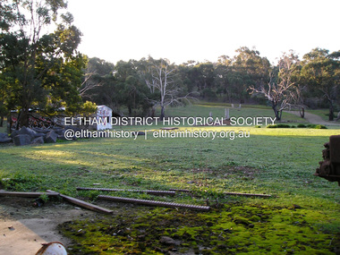
Photograph, Fay Bridge, Former Glynn's Dairy Farm, Glynns Road, North Warrandyte, 31 August 2018
... Glynn’s farm Originally Section 7, Parish of Nillumbik marked Aborigine Reserve in 1866 Crown Allotment 8, Section 7, Parish of Nillumbik, County of Evelyn, Certificate of Title Volume 4095, Folio 818.835, approx. 93 acres purchased by Joseph Panton in 1881 for £1/acre and known as Panton’s Point. By 1924 owned by S.S. Sergeant and called Riverswood. Sergeant commissioned Edna Walling to design the garden...Eltham District Historical Society Inc 728 Main Rd Eltham melbourne Glynn’s farm Originally Section 7, Parish of Nillumbik marked Aborigine Reserve in 1866 Crown Allotment 8, Section 7, Parish of Nillumbik, County of Evelyn, Certificate of Title Volume 4095, Folio 818.835, approx. 93 acres purchased by Joseph Panton in 1881 for £1/acre and known as Panton’s Point. By 1924 owned by S.S. Sergeant and called Riverswood. Sergeant commissioned Edna Walling to design the garden ...Glynn’s farm Originally Section 7, Parish of Nillumbik marked Aborigine Reserve in 1866 Crown Allotment 8, Section 7, Parish of Nillumbik, County of Evelyn, Certificate of Title Volume 4095, Folio 818.835, approx. 93 acres purchased by Joseph Panton in 1881 for £1/acre and known as Panton’s Point. By 1924 owned by S.S. Sergeant and called Riverswood. Sergeant commissioned Edna Walling to design the garden. In September 1929 the property was sold at auction by Mortgagee’s sale. Described as well built, brick, tile roof, Attic Villa containing downstairs 7 good rooms, bath, scullery, inside lavatory, etc. Upstairs 2 bedrooms and sleep out. Outbuildings compromising of brick and weatherboard wash house, stables, workshop, feed room, cow bails, large G.I. Hay shed, etc In January 1931 Riverswood property was proclaimed a sanctuary for native game for the entire year. A private swing bridge crossed the river at Pound Bend was known as Pearson’s bridge after C.W.K. Pearson who bought Riverswood in the early 1930s. The bridge was swept away in the December 1934 floods. Riverswood was sold by C.W.K. Pearson at auction on 25 November 1936. Described as a beautiful farm home of 93 acres and over one mile of River Yarra frontage, modern brick residence, lovely garden, rich river flat pastures, model poultry farm. The fine brick home was destroyed on Black Friday (13 Jan.) 1939. It was still a ruin when the Evelyn Evans purchased Waikowhane above Riverswood in 1940. The Glynn family purchased the Riverswood property in 1941 from Robert and Emily Hannon. Their son Kenneth Patrick Glynn inherited the property and he set about clearing the land during WW2 selling wood. Prior to marriage, Kenneth was living alone on the farm in a house he had built from whatever was available. He used the bluestone foundations from the original fine brick home. He met and married Honora Elizabeth Drew in early 1945 and their daughter Anna grew up on the farm. It was compulsorily acquired by the Board of Works in 1976 who then rented the house out in the 1980s. The property was transferred to Melbourne Parks and Waterways in 1996. Waikowhane was a pretty timber house built on top of the hill on 50 acres above Riverswood by retired nurse Jessie MacBeth. (This would be at the intersection of Glynns Road and Overbank Road where the big water tank is now situated on what was once James Orford’s property.) It was also destroyed Black Friday and she rebuilt it from the plans living in a caravan on site supervising the build. It was almost complete when she died May 1939. The property was bought by Evelyn Evans (a city girl) and her estranged husband in 1940. She had two sons, one only 9 months old at the time. It was a timber house with no power or water connected. The Ewen Cameron family bought Waikowhane in 1957. They had to evacuate when the 1961 bushfires swept through. The house was saved by Matcham Skipper. It was demolished by Melbourne Water in the 1990s when they acquired it.fay bridge collection, 2018-08-31, glynn's, glynn's dairy farm, glynns road, north warrandyte, parks victoria, ruins, riverswood, kenneth patrick glynn -
Glen Eira Historical Society
Letter - Rosstown Railway
... Allotments Land Titles Roads and Streets Rosstown Rail Trail City of Glen Eira Tourism Trains Tourism Information Bureaus Tours Pamphlets Elsternwick Railway Park Oakleigh Junction Princes Park EE Gunn Reserve Packer Park Sites Jowett D.F. Weickhardt I.G. RETURN TO ROSSTOWN: RAILWAYS LAND SALES AND SUGAR BEET VENTURES IN CAULFIELD Land Sales Walking Trails Ross William Murray Transport Objects Locomotion Walking Cycling Driving Sports Country Mansions People Caulfield John Builders Construction and Demolition Workers Occupations Careers Professionals Topography Geology Landforms Horticulture Market Gardens Primary Industry Workers City of Caulfield MOOD KEE Pennington Harold Annual General Meetings Caulfield Town Hall Glen Eira City Council Carnegie Carnegie Station Rosstown Station People by Circumstance Migrants Sugar Beet Sugar Beet Mill Sugar Beet Industry Mills Factories SEA BEACH LINES Bent Thomas Parliamentary Representatives Neville Street Miller Street Lemann’s Swamp Reserve Koornang Park Cane Sugar Industry Breweries Rabbit Processing Plants Health Establishments Hospitals Food Production Establishments Abattoirs Thieves Social Problems Vagrants Theft Squatting Financial Economics Debt Finance Industry Insurance Companies Company Managers Bentleigh Ross Leila THE GRANGE Leila Road Wild Cherry Road Financial Trouble Mortgages Gisborne Street Archibald Street Riddell Parade VICTORIA RAILWAYS Glen Huntly Road Clarence Street College Street Gladstone Parade Parrell Street Aileen Avenue Seaview Street Land Subdivisions Dover Street Sussex Street Landfill Marara Road Booran Road Woodville Avenue Dorothy Avenue Ormond Park Royal Avenue Ormond Railway Station Oakleigh Road Melten Avenue Miller Street Munro Avenue Lord Reserve Neerim Road Toolambool Road The Rosstown Hotel Rosanna Street Murrumbeena Crescent Commercial Establishments The National Bank Rosstown Road Kangaroo Road Poath Road Freda Street Hughesdale Kindergarten Oakleigh Council Hughesdale Community Centre Civic Establishments Galbally Reserve Plaques Warrigal Road OUT AND ABOUT BROCHURES Orion Estate Letter Rosstown Railway ...This file contains four items: 1/A black and white photocopy of a letter dated either 07/08/1889 or 09/08/1889, from Robert Lundon to an unidentified recipient discussing an agreement reached between the author – on behalf of the recipient – and Soon Hang Hi in regard, in regards to the allotment known as Webber’s. The agreement is outlined in the letter in what appears to be Chinese characters, and includes the marks of Robert Lundon and Soon Hang Hi. File note from Joy Wu states that the calligraphy is not Mandarin or traditional Chinese. 2/Three sheets of hand-written working notes with information taken from the Victorian Government Gazette on THE ROSSTOWN AND MURRUMBEENA LAND COMPANY LIMITED, THE ROSSTOWN JUNCTION RAILWAY AND PROSPERITY COMPANY LIOMITED, and THE ROSSTOWN JUNCTION, ELSTERNWICK, AND OAKLEIGH RAILWAY COMPANY LIMITED, covering dates between 1887 and 1894. The notes concern meetings and creditors claims relevant to the companies, with reference numbers for the information source. Date and author of the notes are not recorded. 3/A black and white photocopy of the a partial map of the Rosstown Railway and surrounding area, undated. The map includes the names of landholders in the areas of Brighton, Garden Vale and Elsternwick, as well as other railway lines present in the region. 4/A fold-out map and guide of the Rosstown Rail Trail, including a brief general history of Caulfield as well as a more extensive biography of William Murray Ross and the Rosstown Railway. The map marks and describes significant sites along the trail, including photographs of some of these sites, provided by DF Jowett.documents, correspondence, webber’s, lundon robert, chinese characters, ethnic communities, signatures, text, settlements, taxes, fraser john grieves, lovell r.h., price davies, meetings, communication activities, soon hang hi, commercial events and activities, the rosstown and murrumbeena land company limited, victorian government gazette, bulmer richard, parry john, osment henry, shareholders, creditors claims, the rosstown junction railway and property company limited, finch and best, lawyers, the rosstown junction elsternwick and oakleigh railway company limited, cameron w.c., phillips p.d., garden vale, elsternwick, elsternwick railway station, rosstown, rosstown railway, thomas street, bay street, kooyong road, melbourne and brighton railway, hawthorn road, bambra road, caulfield and frankston railway, booran road, grange road, koornang road, murrumbeena road, north road, north road railway station, east brighton railway station, south road, railway routes, railway lines, railways, land transport, murphy j., caulfield, hamilton t.f., dane p., holloway, webb, ailee john, payne t.b., brodie chas, dane john, o’neil h., mccombie john, mcmillane a., smyth c.d., cooper, ebden, landholders, jeffrey j.d., gill j., balcombe a.e., cooper h., mcnab j., white j., sutherland j., greeves a.f.a., newton m.c., chamley f.b., fowler j., inglis p., grant t., stooke j., swanson g., cochrane c., adams e.b., mccombie thas, keyes robert, brighton cemetery, burials grounds and graveyards, war-ein road, were j.b., holland j., mcmahon c., winter t.l.m., dendy henry, mitchell w., jackson s., were j.e., wickham francis dawe, bryant jane, east brighton railway station, railway stations, maps, allotments, land titles, roads and streets, rosstown rail trail, city of glen eira, tourism, trains, tourism information bureaus, tours, pamphlets, elsternwick railway park, oakleigh junction, princes park, ee gunn reserve, packer park, sites, jowett d.f., weickhardt i.g., return to rosstown: railways land sales and sugar beet ventures in caulfield, land sales, walking trails, ross william murray, transport objects, locomotion, walking, cycling, driving, sports, country mansions, people, caulfield john, builders, construction and demolition workers, occupations, careers, professionals, topography, geology, landforms, horticulture, market gardens, primary industry workers, city of caulfield, mood kee, pennington harold, annual general meetings, caulfield town hall, glen eira city council, carnegie, carnegie station, rosstown station, people by circumstance, migrants, sugar beet, sugar beet mill, sugar beet industry, mills, factories, sea beach lines, bent thomas, parliamentary representatives, neville street, miller street, lemann’s swamp reserve, koornang park, cane sugar industry, breweries, rabbit processing plants, health establishments, hospitals, food production establishments, abattoirs, thieves, social problems, vagrants, theft, squatting, financial economics, debt, finance industry, insurance companies, company managers, bentleigh, ross leila, the grange, leila road, wild cherry road, financial trouble, mortgages, gisborne street, archibald street, riddell parade, victoria railways, glen huntly road, clarence street, college street, gladstone parade, parrell street, aileen avenue, seaview street, land subdivisions, dover street, sussex street, landfill, marara road, booran road, woodville avenue, dorothy avenue, ormond park, royal avenue, ormond railway station, oakleigh road, melten avenue, miller street, munro avenue, lord reserve, neerim road, toolambool road, the rosstown hotel, rosanna street, murrumbeena crescent, commercial establishments, the national bank, rosstown road, kangaroo road, poath road, freda street, hughesdale kindergarten, oakleigh council, hughesdale community centre, civic establishments, galbally reserve, plaques, warrigal road, out and about brochures, orion estate -
Glen Eira Historical Society
Map - CAPLES PLACE SUBDIVISION
... Land Subdivisions Documents Maps Glen Eira CAPLES PLACE CAPLES PLACE Subdivision Land Surveys Orrong Road Mulgrave Road Prahran Grove Somerset Road Prahran Grove Prahran Grove East Walk Land Allotments Town Planning Garden Road Map CAPLES PLACE SUBDIVISION ...This file contains a copy of a map of the CAPLES PLACE SUBDIVISION, undated and author unknown. The map provides the dimensions of roads and allotments in the area, including also handwritten notes from the original document and others written directly onto the copy.land subdivisions, documents, maps, glen eira, caples place, caples place subdivision, land surveys, orrong road, mulgrave road, prahran grove, somerset road, prahran grove, prahran grove, east walk, land allotments, town planning, garden road -
 Eltham District Historical Society Inc
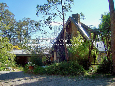
Photograph - Digital Photograph, Marguerite Marshall, Former home of Professor William MacMahon Ball, York Street, Eltham, 24 May 2007
... The underground well, cellar and part of the garden are all that remain of what stood on the original 18 acre (7.3ha) allotment. ...The underground well, cellar and part of the garden are all that remain of what stood on the original 18 acre (7.3ha) allotment. ...Situated at the eastern end of York Street, Eltham, 'Shinrone', the former home of Professor William (Mac) MacMahon Ball was one of the first in the Shire of Eltham to incorporate mud-brick. Professor MacMahon Ball, a political scientist, writer, broadcaster and diplomat and family moved to York Street, Eltham in 1945 into a timber cottage built around the 1890s and in poor repair. Mac asked Alistair Knox to renovate the home and he expanded the living area and added verandahs. In 1948 Montsalvat artist and sculptor Sonia Skipper supervised the building of most of the mud-brick studio. Neighbour Gordon Ford made the mud-bricks. Mac also asked John Harcourt, who had worked with him as a journalist in shortwave broadcasting, to build a pise (rammed earth) and stone addition to the largely timber house. Harcourt built two bedrooms - including an attic bedroom - a balcony with a shower and toilet, a nd a fireplace and chimney of local stone. Published: Nillumbik Now and Then / Marguerite Marshall 2008; photographs Alan King with Marguerite Marshall.; p141 At the eastern tip of York Street, Eltham, stands Shinrone, the former home of one of Australia’s intellectual leaders. Professor William Macmahon Ball, was one of the first to bring Asia as a foreign policy issue to the Australian public.1 He was a political scientist, writer, broadcaster and diplomat. The house was one of the first in Eltham Shire to incorporate mud-brick,2 because of the acute shortage of building materials after World War Two. Its novice builders later become leaders in Eltham’s built and garden design. Mac (as he was usually called), who was the son of a Church of England minister, was born in Casterton, Victoria in 1901 and died in 1986. In 1945 he helped establish the United Nations, as political consultant to the Australian Delegation at the San Francisco Conference.3 Then in 1946 Mac was appointed British Commonwealth Representative on the Allied Council for Japan, which is recorded in detail in his diary.4 In 1948 Mac led an Australian Government Goodwill Mission to South East Asia. However, Mac was perhaps most successful as an academic and public speaker.5 He was a commentator on the Australian Broadcasting Commission, from the early 1930s to the early 1960s. He was also Controller of the Short-Wave Broadcasting Unit during World War Two, which later became Radio Australia. From 1923 he taught at The University of Melbourne, then became foundation Professor of Political Science in 1949 and was Chair until his retirement in 1968.6 In 1942, as the government expected a Japanese invasion, Mac’s wife Katrine and their only child Jenny, moved from Kew to Eltham as temporary evacuees. However Mac and Katrine lived in Eltham for almost the rest of their lives. After staying with friends, they rented a house in Reynolds Road, where, as it was wartime, they needed to keep horses for transport and a cow and poultry for milk and eggs. In 1945 the family moved to the house at York Street, which was then a timber cottage, built around the 1890s and in poor repair. The underground well, cellar and part of the garden are all that remain of what stood on the original 18 acre (7.3ha) allotment. Thanks largely to Katrine’s hard work, the house was gradually renovated and extended. The long rambling house was partially built by several young neighbours, who were inspired by the cheap mud-brick and stone building style of Montsalvat, the Eltham artists’ colony. Mac asked Alistair Knox to renovate Shinrone, named after an Irish village near Katrine’s family home. Knox later popularised the mud-brick style of house construction, for which Eltham became known. He expanded the living area and added verandas. In 1948 Montsalvat artist and sculptor Sonia Skipper supervised the building of most of the mud-brick studio. Another neighbour, Gordon Ford, who was to have a major influence on the Australian garden style, made the mud-bricks. Mac also asked John Harcourt, who had worked with him as a journalist in short-wave broadcasting, to build a pisé (rammed earth) and stone addition to the largely timber house. Harcourt built two bedrooms – including an attic bedroom – a balcony with a shower and toilet, and a fireplace and chimney of local sandstone. With pioneering work naturally came mistakes, including one particularly dramatic incident when Harcourt was building walls with unsupported sections. Jenny Ellis, Mac’s daughter, remembers being awakened from sleep by a thundering shudder. The wall of her room had fallen down – fortunately away from her! In 1950 artist Peter Glass – another neighbour and later landscape designer – built Katrine a mud-brick pottery. As a result, the house features at one end Harcourt’s characteristic steep gable roof, while at the other the flatter construction characteristic of Knox. Mac referred to the home as the Eltham ‘experimental building site’.7 Surprisingly, the combination works, perhaps partly because it has the warm inviting feel of timber, mud-brick and stone.This collection of almost 130 photos about places and people within the Shire of Nillumbik, an urban and rural municipality in Melbourne's north, contributes to an understanding of the history of the Shire. Published in 2008 immediately prior to the Black Saturday bushfires of February 7, 2009, it documents sites that were impacted, and in some cases destroyed by the fires. It includes photographs taken especially for the publication, creating a unique time capsule representing the Shire in the early 21st century. It remains the most recent comprehenesive publication devoted to the Shire's history connecting local residents to the past. nillumbik now and then (marshall-king) collection, eltham, alistair knox, gordon ford, john harcourt, mudbrick construction, pise construction, professor macmahon ball, shinrone, sonia skipper, york street -
 Glen Eira Historical Society
Album - Album page, Normanby Road, Circa 1972
... allotments, only "Wisteria" survives at No. 135 Normanby Road. Adopting forms and timber enrichment characteristic of the American Queen Anne style, it has this in common with the largely reconstructed timber villa at no. 11 Normanby Avenue and to a lesser extent, 746 Inkerman Road. Normanby Road retains its comparatively opulent Edwardian character in a mature landscaped setting with spacious gardens...allotments, only "Wisteria" survives at No. 135 Normanby Road. Adopting forms and timber enrichment characteristic of the American Queen Anne style, it has this in common with the largely reconstructed timber villa at no. 11 Normanby Avenue and to a lesser extent, 746 Inkerman Road. Normanby Road retains its comparatively opulent Edwardian character in a mature landscaped setting with spacious gardens ...This photograph is part of the Caulfield Historical Album 1972. This album was created in approximately 1972 as part of a project by the Caulfield Historical Society to assist in identifying buildings worthy of preservation. The album is related to a Survey the Caulfield Historical Society developed in collaboration with the National Trust of Australia (Victoria) and Caulfield City Council to identify historic buildings within the City of Caulfield that warranted the protection of a National Trust Classification. Principal photographer thought to be Trevor Hart, member of Caulfield Historical Society. Most photographs were taken between 1966-1972 with a small number of photographs being older and from unknown sources. All photographs are black and white except where stated, with 386 photographs over 198 pages. From: Glen Eira Heritage Management Plan (1996) - Vol 2 by Andrew Ward and Associates The widening of Dandenong Road during the late 1980's has resulted in the destruction of the houses in the path of the roadworks and the construction of a high fence serving as a visual barrier between that thoroughfare and the remaining houses. Where comparatively large villas once stood on spacious allotments, only "Wisteria" survives at No. 135 Normanby Road. Adopting forms and timber enrichment characteristic of the American Queen Anne style, it has this in common with the largely reconstructed timber villa at no. 11 Normanby Avenue and to a lesser extent, 746 Inkerman Road. Normanby Road retains its comparatively opulent Edwardian character in a mature landscaped setting with spacious gardens and mature planes parallel with the railway reserve which, on account of the low lying ground in its vicinity has a high embankment commencing on the alignment of Malvern Grove and continuing to Caulfield Station. The earliest villas are Edwardian. Page 148 of Photograph Album with one landscape photograph of a house on Normanby Road (not Street).Handwritten: Normanby St [top right] / 148 [bottom right]trevor hart, verandah, porch, bull nosed verandah, tower house, tower, stone fence, normanby road, wisteria, american queen anne style, queen anne style, 1890's, mayfield grove, normanby street, timber houses, caulfield north, house names, edwardian, edwardian style, gardens -
Glen Eira Historical Society
Map - Cantala
... allotments. There is an extra copy of the final page of this larger poster. Miller Septimus Miller Helen M McIntyre Angus Miller N A Crouch H C Cantala Dandenong Road Wiora Alma Road Waiora Road Findon Avenue Cantala Avenue Caulfield Caulfield North St Kilda East Yeo Grosthwaite and Co Abercromby and Beatty Pty Ltd Mansions Land subdivision House auctions Auctioneers Land sales Land values Architectural features Gardens Advertisements Racehorses Road construction and maintenance Surveyors Lawyers Minute books Trams Map Cantala ...Six pages of handwritten notes, undated and unattributed, detailing the history of the subdivision and demolition of Cantala, Dandenong Road, 40, Caulfield. The notes, which include a list of references, detail the main auction on 21/05/1938 and prices paid for the allotments. Also included in the file are photocopies of three auction posters for the 21/05/1938 auction in 32 allotments. Two of the posters are small and one of these includes a map (107mm x 110mm) of the Cantala Estate. The other poster is spread across three A4 pages and includes a map and plan (204mm x 110mm) of the allotments. There is an extra copy of the final page of this larger poster.miller septimus, miller helen m, mcintyre angus, miller n a, crouch h c, cantala, dandenong road, wiora, alma road, waiora road, findon avenue, cantala avenue, caulfield, caulfield north, st kilda east, yeo grosthwaite and co, abercromby and beatty pty ltd, mansions, land subdivision, house auctions, auctioneers, land sales, land values, architectural features, gardens, advertisements, racehorses, road construction and maintenance, surveyors, lawyers, minute books, trams -
 Eltham District Historical Society Inc
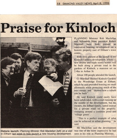
Drawing - Newspaper clipping, Praise for Kinloch, Diamond Valley News, April 8, 1998, p11, April 1998
... Cr Marshall likened Kinloch Gardens to the Woodridge Estate at Eltham, which he said provided housing on small allotments while protecting much of the tree canopy, and "showed how a suburb can be built". ...Cr Marshall likened Kinloch Gardens to the Woodridge Estate at Eltham, which he said provided housing on small allotments while protecting much of the tree canopy, and "showed how a suburb can be built". ...PLANNING Minister Rob Maclellan and Nillumbik Shire president Robert Marshall have both praised an innovative housing development on a historic property east of Eltham's town centre. Both were present at the launch of the Kinloch Gardens development, where 12 new double and triple storey homes will be built along a private road in the gardens of Kinloch, a mansion set on 2.4ha in Arthur St. About 100 people attended the launch. Cr Marshall likened Kinloch Gardens to the Woodridge Estate at Eltham, which he said provided housing on small allotments while protecting much of the tree canopy, and "showed how a suburb can be built". He said Kinloch could easily have been subdivided, with a court running up the middle of the development, but the owners, the Jelbart family, opted instead for a private road on the property, sweeping around a common pond and 'village green'. ''This is a perfect example of what can be achieved in urban planning,'' he said. Mr Maclellan said the development was one of the most impressive he had seen in his role as Planning Minister Picture - Historic launch: Planning Minister Rob Maclellan (left) on a visit to Eltham last week to help launch a new housing development.Digital file only; created from scan undertaken by EDHS of item on loanarthur street, eltham, graeme gunn, houses, ian jelbart, jelbart property, kinloch gardens, rob maclellan, robert marshall, woodridge estate -
 Eltham District Historical Society Inc
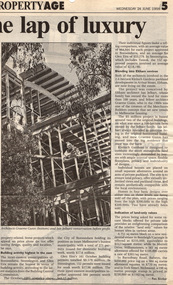
Document - Newspaper clipping, "The lap of luxury; Blending into Eltham environ", Property Age, The Age, Wednesday 24 June 1998, p5, June 1998
... Kinloch Gardens is designed to combine the more manageable land sizes increasingly demanded by buyers with ample "internal space, flexible floorplans, privacy and individuality of designs. Individual houses are placed on small separate allotments...Kinloch Gardens is designed to combine the more manageable land sizes increasingly demanded by buyers with ample "internal space, flexible floorplans, privacy and individuality of designs. Individual houses are placed on small separate allotments ...Both of the architects involved in the 2.4-hectare Kinloch Gardens parkland development in Arthur Street, Eltham, are now living on the estate. The project was conceived by Eltham architect Ian Jelbart, whose family has owned the land for more than 100 years, and fellow architect Graeme Gunn, who in the 1960s was one of the creators of the Merchants Builders concept that set new trends in Melbourne housing. The $5 million project is based around two of the original buildings, on what was once a 100-hectare farm owned by the Jelbart family. Ian Jelbart always intended to continue living in the original homestead building, and now Graeme Gunn has moved into the big residence that once was the barn. Kinloch Gardens is designed to combine the more manageable land sizes increasingly demanded by buyers with ample "internal space, flexible floorplans, privacy and individuality of designs. Individual houses are placed on small separate allotments around an area of private parkland. The aim is to ensure total privacy, offer virtually unlimited views and parkland vistas, and remain aesthetically compatible with the local environment. Homes in four basic designs over either two or three levels are being sold off the plan, with prices ranging from the high $200,000s to the high $300,000s. Two have already been sold. Indication of land-only values The prices being asked for some vacant blocks offered for private sale provides an enlightening comparison of the relative "land only" values for homes sites in various areas. A 751 sq metre block on a new residential estate in Bentleigh/Carnegie is offered at $235,000, equivalent to $312/square metre; while in Merrett Drive, Williamstown, a 561 sq metre allotment offered for $169,000 carries a rate of $301/sq metre. In Barnsbury Road, Balwyn, the $450,000 price tag on a 584 sq metre allotment equates to $770 sq metre; and in York Street, Richmond, a 198 sq metre postage stamp is priced at $230,000 or $1162/sq metre. - Rex BookerDigital file only; created from scan undertaken by EDHS of item on loanarthur street, eltham, graeme gunn, houses, ian jelbart, jelbart property, kinloch gardens, rob maclellan, robert marshall, woodridge estate -
 Eltham District Historical Society Inc
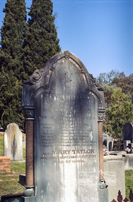
Negative - Photograph, Harry Gilham, Grave of Abraham and Ann Taylor, also Mary Taylor, Eltham Cemetery, Victoria, Sep 2009
... In June 1871, Abraham Taylor, Eltham gardener, applied for a 120-acre allotment half a mile northeast of the Research Gully Hotel on June 30, 1871. ...In June 1871, Abraham Taylor, Eltham gardener, applied for a 120-acre allotment half a mile northeast of the Research Gully Hotel on June 30, 1871. ...Abraham Taylor was born 20 October 1811 in Derrycarn, Drumcree Parish, County Armagh, Ireland, the son of Richard William Taylor and Annie Abraham. He married Ann McClelland on 19 February 1852 in Dumcree. They emigrated to Australia arriving in Geelong aboard the Ann Thompson on Christmas Day, 1852. His younger sisters Mary and Martha and brother William John all having separately preceded them in 1851 and 1852. Abraham and Ann settled in Little Eltham, Abraham was recorded as being 40 years of age and Ann, 36. They made their home and living as an orchardist and gardener where they had three sons, William John (1853 Little Eltham), Richard (1855 Eltham) and Robert David (1857 Eltham), tow of whom became Councillors of the Shire of Eltham; William (1890-1911) and Robert David (1911-1920). In June 1871, Abraham Taylor, Eltham gardener, applied for a 120-acre allotment half a mile northeast of the Research Gully Hotel on June 30, 1871. A license was issued to him January 30, 1872, for 114 acres, being Allotment 8, Section 18, the balance of 6 acres being retained for reserve. He built on the land a two roomed dwelling of slabs and palings. He and his family lived there or at their 6 ½ acre Eltham property, which was used for orchard and garden as a residence. In January 1875 a lease issued to Abraham Taylor for the land one chain wide each side at the gully named ‘Wet Gully’ was excluded. In August 1881 Abraham Taylor paid up all fees and applied for a Crown grant. He vainly requested that the grant be issued to his son, Robert David Taylor, Eltham however the grant was in fact issued to Abraham Taylor, Eltham, gardener. Abraham died at home on June 1, 1890. He was greatly respected by all who knew him. His sister Mary predeceased him 1873and is also buried at Eltham cemetery. Wife Ann died at home 1 September, 1893 and was buried with him. In Loving Remembrance of Abraham Taylor Who died June 1st 1890 Aged 80 years Also Ann Taylor Wife of the above Who died September 1st 1893 Aged 75 years Also Mary Taylor Who died September 22nd 1873 Aged 45 yearsRoll of 35mm colour negative film, 6 stripsKodak GC 400-9eltham cemetery, gravestones, abraham taylor, ann taylor, mary taylor -
 Ringwood and District Historical Society
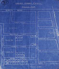
Map, Plan of Subdivision - Cherry Garden Estate, Ringwood East, Victoria. Circa 1950
... Ringwood and District Historical Society 125A Warrandyte Road Ringwood North melbourne Map includes Dublin Road, Shasta Avenue, Education Department land in Alexandra Road, and numbered allotments in Knaith Road, Northwood Street, Langley Street and Bondi Street, Ringwood East, Victoria. Blue hand-drawn map of residential subdivision surrounding Tintern School. Plan of Subdivision - Cherry Garden ...Blue hand-drawn map of residential subdivision surrounding Tintern School.Map includes Dublin Road, Shasta Avenue, Education Department land in Alexandra Road, and numbered allotments in Knaith Road, Northwood Street, Langley Street and Bondi Street, Ringwood East, Victoria. -
 Ringwood and District Historical Society
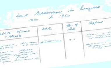
Document - Research Notes, Richard Carter, Land Subdivisions in Ringwood 1890-1950
... Garden Street, Bellevue Avenue Pg28 RINGWOOD (unnamed estate - 1926) Nelson Street, Seymour Street, Whitehorse Road Pg29 EAST RINGWOOD RAILWAY STATION ESTATE (YEAR? - 25 shops 60 villas) Railway Avenue, Dublin Road, Lawrence Grove, Stanley Avenue, Knaith Road Pg30 CHARM VIEW ESTATE (LP?) (year? - after 1926) Canterbury Road, Heathmont Road, Dickasons Road, Bennjett Avenue, Orchid Street Pg31 SUNBEAM ESTATE LP12150 (Circa 1925) Govt Road (now Old Lilydale Road), Sunbeam Avenue, Holland Road, Everard Street (now Everard Road) Pg32 FAIRVIEW ESTATE EAST RINGWOOD LP10853 (Circa 1924) Eastfield Road, Patterson Street, Margaret Street (now Short Street) Pg33 EAST RINGWOOD TOWNSHIP ESTATE LP3025 (Circa 1924 - 35 allotments) Mount Dandenong Road, Grey Street, Eastfield Road Pg34 EAST RINGWOOD TOWNSHIP ESTATE LP3025 (Circa 1924 - 49 allotments) and STATE SCHOOL ESTATE (26 allotments) and EAST RINGWOOD STATION ESTATE (14 shop sites) Mount Dandenong Road, Grety Street, Dunn Street, Eastfield Road, King Street, Holland Road, Dublin Road, Patterson Street, Bona Street Pg35 EAST RINGWOOD CENTRAL ESTATE LP17004 (1948) Knaith Road, Shasta Avenue, Talofa Avenue, Russet Road, Dublin Road Pg36 WARE ESTATE LP43360 (1958) Ware Crescent, Davey Drive, Grey Road (now Grey Street), Mount Dandenong Road Pg37 Lot 57 Kendall Street LP3070 (1939) £75.0.0 Pg37 Lot 14 LP7346 (year?) ...Garden Street, Bellevue Avenue Pg28 RINGWOOD (unnamed estate - 1926) Nelson Street, Seymour Street, Whitehorse Road Pg29 EAST RINGWOOD RAILWAY STATION ESTATE (YEAR? - 25 shops 60 villas) Railway Avenue, Dublin Road, Lawrence Grove, Stanley Avenue, Knaith Road Pg30 CHARM VIEW ESTATE (LP?) (year? - after 1926) Canterbury Road, Heathmont Road, Dickasons Road, Bennjett Avenue, Orchid Street Pg31 SUNBEAM ESTATE LP12150 (Circa 1925) Govt Road (now Old Lilydale Road), Sunbeam Avenue, Holland Road, Everard Street (now Everard Road) Pg32 FAIRVIEW ESTATE EAST RINGWOOD LP10853 (Circa 1924) Eastfield Road, Patterson Street, Margaret Street (now Short Street) Pg33 EAST RINGWOOD TOWNSHIP ESTATE LP3025 (Circa 1924 - 35 allotments) Mount Dandenong Road, Grey Street, Eastfield Road Pg34 EAST RINGWOOD TOWNSHIP ESTATE LP3025 (Circa 1924 - 49 allotments) and STATE SCHOOL ESTATE (26 allotments) and EAST RINGWOOD STATION ESTATE (14 shop sites) Mount Dandenong Road, Grety Street, Dunn Street, Eastfield Road, King Street, Holland Road, Dublin Road, Patterson Street, Bona Street Pg35 EAST RINGWOOD CENTRAL ESTATE LP17004 (1948) Knaith Road, Shasta Avenue, Talofa Avenue, Russet Road, Dublin Road Pg36 WARE ESTATE LP43360 (1958) Ware Crescent, Davey Drive, Grey Road (now Grey Street), Mount Dandenong Road Pg37 Lot 57 Kendall Street LP3070 (1939) £75.0.0 Pg37 Lot 14 LP7346 (year?) ...Handwritten table listing main local pre-1950s subdivisions in the Ringwood area, with estate names, streets, number of allotments for sale, and where known, vendor agent, LP (Lodged Plan) title registration number, and auction/sale date, some with sale price.Pg1 RINGWOOD STATION ESTATE LP3070 (Year?) Station Street, William Street (now Kendall Street), Wantirna Road, Station Street Pg1 RINGWOOD TOWNSHIP ESTATE LP5577 (1913) Station Road (now Warrandyte Road), Pratt Street (part now Aird Street), Whitehorse Road Pg2 RINGWOOD ORCHARD ESTATE LP4315 (1914) Brysons Road, Hillcrest Road, Anzac Avenue, Sulva Road Pg3 RINGWOOD RAILWAY ESTATE LP7522 (1918) Whitehorse Road (now Mount Dandenong Road), Dublin Road, Freeman Street, Patterson Street, Bona Street Pg4 THE RINGWOOD ESTATE LP7578 (1919) Warrandyte Road, Hobart Street, Paxton Street, Arnold Street Pg5 GARDEN FARMS ESTATE (LP?) (1919) Canterbury Road, Armstrong Road, Bungalook Road, Orchard Road, Bayswater Road (now Mountain Highway) Pg6 THE RINGWOOD ESTATE (SECOND SUB-DIVISION) LP7604 (1919) Warrandyte Road, Tamar Street, Derwent Street, Mersey Street Pg7 RINGWOOD STATION ESTATE LP7703 (1919) Bedford Road, Williams Grove (now Lena Grove) Pg8 RINGWOOD TOWNSHIP ESTATE LP8198 (1919) Wantirna Road, Ellison Street, Haig Street, Greenwood Avenue Pg9 EASTFIELD ESTATE (LP?) (1920) Eastfield Road, Longview Road, Pleasant Rise, The Mount Pg10 ELECTRIC RAILWAY ESTATE RINGWOOD LP9473 (1922) Campbell Street, Myrtle Avenue, George Street (now Tudor Court), Henry Street (now Myrtle Avenue), Williams Grove (now Lena Grove) Pg11 RINGWOOD PARK ESTATE LP7884 (1922 - two stages) Wonga Road (now Loughnan Road), William Street, Andrew Street, Harrison Street Pg12 HEATHMONT STATION ESTATE LP11009 (Date? - after 1922) Lisgoold Street, Viviani Crescent, Balrour Avenue, Station Street (now part Heathmont Road and part Wainui Street) Pg13 RINGWOOD RAILWAY ESTATE LP10507 (1923) Whitehorse Road, Sherbrooke Avenue, Burwood Avenue, Bonview Avenue, Heatherbrae Avenue, Grant Crescent Pg14 GARDEN HOMES ESTATE (LP?) (1923) Mullum Road, The Centreway, Wattle Crescent (now Wattle Avenue) Reserve Crescent (now Reserve Road) Pg15 DUBLIN ROAD ESTATE LP11993 (1923) Alexandra Road, Vonadawn Avenue, Green Street, Wood Street, Howard Avenue, Bedford Road, Dublin Road Pg16 CARLINGA ESTATE RINGWOOD LP9620 (1923) Bourke Street, Bond Street, Ringwood Street Pg17 PRATT'S JUNCTION ESTATE (LP?) (1923) Junction Street, Georges Road, Oliver Street, Whitehorse Road Pg18 EAST RINGWOOD ESTATE LP10492 (1923) Bona Street, Patterson Street, Miller Grove, Fairview Avenue, Eastfield Road, Whitehorse Road (now Mount Dandenong Road) Pg19 COLEMAN'S HEATHMONT ESTATE LP9974 (1923) Canterbury Road, Bedford Road, Alvena Crescent, Coleman Street, Leonard Street (now Royal Avenue) Pg20 RINGWOOD HEIGHTS ESTATE LP10506 (1924) Whitehorse Road, Bonview Avenue, Grant Crescent, Hillcrest Avenue, Heatherbrae Avenue, Margaret Street, Mary Street Pg21 EAST RINGWOOD STATION ESTATE LP10551 (1924) Knaith Road, Wenwood Street, Lois Street, Victoria Street, Station Street (now Railway Avenue) Pg22 GRAND VIEW ESTATE LP11019 (1924) Whitehorse Road, Rupert Street, Herbert Street, Leonard Street Pg23 RINGWOOD RAILWAY ESTATE & RINGWOOD HEIGHTS ESTATE - FINAL SECTIONS LP10506 & LP10507 (1924) Whitehorse Road, Sherbrooke Avenue, Burwood Avenue, Bonview Avenue, Heatherbrae Avenue, Margaret Street, Mary Street, Grant Crescent Pg24 RINGWOOD EAST ELECTRIC STATION ESTATE (LP?) (1924) Railway Parade (now Patterrson Street), Federal Road, Howship Avenue (part now French Street), Dublin Road, Rosedale Crescent Pg25 BEDFORD PARK (now Ringwood Secondary College) (LP?) (1924) Bedford Road, Adams Street, Anderson Street, Joyce Street, Graham Road Pg26 CROWN JEWEL ESTATE LP11645 (Private sales after 1924) Mount Dandenong Road, Mirabel Avenue, Valda Avenue, Evon Avenue, Velma Grove Pg27 GRAND CENTRAL ESTATE LP10917 (1925) Heathmont Road, Great Ryrie Street, Douglas Street, Garden Street, Bellevue Avenue Pg28 RINGWOOD (unnamed estate - 1926) Nelson Street, Seymour Street, Whitehorse Road Pg29 EAST RINGWOOD RAILWAY STATION ESTATE (YEAR? - 25 shops 60 villas) Railway Avenue, Dublin Road, Lawrence Grove, Stanley Avenue, Knaith Road Pg30 CHARM VIEW ESTATE (LP?) (year? - after 1926) Canterbury Road, Heathmont Road, Dickasons Road, Bennjett Avenue, Orchid Street Pg31 SUNBEAM ESTATE LP12150 (Circa 1925) Govt Road (now Old Lilydale Road), Sunbeam Avenue, Holland Road, Everard Street (now Everard Road) Pg32 FAIRVIEW ESTATE EAST RINGWOOD LP10853 (Circa 1924) Eastfield Road, Patterson Street, Margaret Street (now Short Street) Pg33 EAST RINGWOOD TOWNSHIP ESTATE LP3025 (Circa 1924 - 35 allotments) Mount Dandenong Road, Grey Street, Eastfield Road Pg34 EAST RINGWOOD TOWNSHIP ESTATE LP3025 (Circa 1924 - 49 allotments) and STATE SCHOOL ESTATE (26 allotments) and EAST RINGWOOD STATION ESTATE (14 shop sites) Mount Dandenong Road, Grety Street, Dunn Street, Eastfield Road, King Street, Holland Road, Dublin Road, Patterson Street, Bona Street Pg35 EAST RINGWOOD CENTRAL ESTATE LP17004 (1948) Knaith Road, Shasta Avenue, Talofa Avenue, Russet Road, Dublin Road Pg36 WARE ESTATE LP43360 (1958) Ware Crescent, Davey Drive, Grey Road (now Grey Street), Mount Dandenong Road Pg37 Lot 57 Kendall Street LP3070 (1939) £75.0.0 Pg37 Lot 14 LP7346 (year?) £225 Pg37 Lot 8 WHITE HORSE ESTATE LP14010 (year?) Maroondah Hwy, Seymour Street £98.9.0 Pg37 Lots 4-14 incl. LP10902 (year?) £300 Pg37 Lots 69&70 LP2216 (1939) Bedford Road, Pitt Street £500 Pg37 Lots 60&70 LP2216 (year?) £460 Pg37 MOUNTAIN VIEW ESTATE LP10902 (1936) Lots 1&2, 19-22 Wantirna Road, Daisy Street £50 Pg38 RAILWAY STATION ESTATE RINGWOOD EAST LP7522 (1925) Lots 16 to 19 £250 Pg38 RINGWOOD PARK ESTATE (LP?) (1924) Lot 112 Munro Street £230 Pg38 RINGWOOD TOWNSHIP ESTATE (LP?) (1925) Lot 57 Wantirna Road £850 Pg38 ELECTRIC RAILWAY ESTATE LP9473 (1925) Lot 98 & 99 £180 (30/- foot) Pg38 ELECTRIC RAILWAY ESTATE LP9473 (year?) Lot 100 £233.12.6 incl improvements (£2.12.6 foot) Pg38 Lot 22&23 Bedford Road Heathmont (LP & year?) £675 incl improvements Pg39 Lot 9 Mullum Mullum Road LP8221 (1923) £150 Pg39 Lot 27 Haig Street LP8198 (1925) £825 Pg39 Lot 56 Haig Street cnr Wantirna Road LP8198 (1923) £171 Pg39 Lots 3 & 4 Loughnan Road LP9626 (192?) £147 Pg39 Lots 98 & 99 Myrtle Avenue LP9473 (1925) £180 Pg39 Lots 80 & 81 Myrtle Avenue LP9473 (1929) £150 Pg39 Lot 30 Sherbrooke Avenue LP10507 (1926) £700 incl improvements Pg40 Lot 10 (year?) LP7703 £750 Pg40 Lot 36 (year?) LP7522 £25 Pg40 Lot 38 Pitt Street LP2216 (year?) £350 Pg40 Lot 7 Dublin Road cnr Green Street LP11993 (year?) £300 -
 Ringwood and District Historical Society
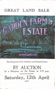
Pamphlet, G.A. Green, Auction Sale Brochure - Garden Farms Estate, Ringwood, Victoria - 1919, 1919
... Garden Farms Estate. Estate outlined in white ring. (Image) Site of New Bridge over Dandenong Creek. (Image) On one of the timbered lots adjoining railway. (Image) This Dandenong Creek traveres the Estate. (Image) Main Fern Tree Gully Line bisects the Estate. Multi-fold brochure advertising public auction of one-acre, 2-acre, 5-acre and 8-acre allotments ...Multi-fold brochure advertising public auction of one-acre, 2-acre, 5-acre and 8-acre allotments in Ringwood and Bayswater on Saturday 12th April, 1919. Brochure includes terms of sale, description of subdivision features and local facilities, and photographic images of the area.Subdivison includes Canterbury Road Heathmont, Armstrong Road Heathmont, Armstrong Road Bayswater, Bungalook Road Heathmont, Bungalook Road Bayswater, and Orchard Road Bayswater. Road shown as Bayswater Road to Bayswater became Mountain Highway Bayswater. Vendor: H.E.B.Armstrong, Auctioneers: Coghill & Haughton, 79 Swanston Street Melbourne, Telephone Central 2793, in conjunction with J.B. McAlpin, Ringwood, Opposite Station, Telephone Ringwood 7. (Map) Woodcock & McCormack, Civil Engineers Architects & Surveyors, 430 Little Collins Street, Melbourne, Phone 3241 Central. MOST OF THE MONEY COMES OUT OF THE LAND. And more money can be obtained from anb acre of fruit than from an acre of any other produce. But you do not have to grow fruit on Garden Farms Estate. You can go in for - Outer Suburban Home - Market Garden - Orchard - Pig Raising - Poultry Farm - Small Dairy Farm - Small Fruits - Floral Culture - Scent and Bee Farm - Or just for a Week-end Home. RINGWOOD - THE PLACE TO LIVE. The Beautiful Ringwood District has so many natural attractions, that half a Land Agent's work is done in just showing a prospective buyer round and about. Ringwood has a pull of its own that attracts folk, proved beyond doubt by its rapid development within the last decade (spite the war). First, it is high and healthy, picturesque and undulating, convenient of access, sufficiently close to the Metropolis for City and Business folk to live at Ringwood. Its development is solid, because most of its people are industrious husbandmen, real producers, who have turned idle hills into smiling gardens. These are the kind of real people to live amongst; ones who wear out their spades. The rapidly-developing town has excellent Stores, Trade and Repair Shops Churches, Banks, Telephone Exchange, Weekly General Market, Cool Stores, and good Private and State Schools, etc.; is Electrically lit, has Metropolitan Water Supply, and generally provides so that practically all shopping can be done locally. WHY RINGWOOD MUST GROW. Ringwood is a great centre and must be a greater. Two rapidly-developing railways junction here. The passengers from Ringwood Station cityward, in one year, number 250,000. Ringwood will be the terminus of the Outer Suburban Electric Eastern Railway. Its natural boundaries are the River Yarra on the North, Dandenong Creek on the South, the popular town of Croydon on the East, and the suburb of Mitcham on the West. This is a large territory that is steadily being converted from intense culture, and then it might be called (as regards its gardens) "The Devon Territory of Victoria." ARMSTRONG ROAD. This new road traverses Garden Farms Estate from its northern boundary on the main Canterbury Road, across Dandenong Creek, to its southern boundary on the main Bayswater Road, and will provide a long-desired additional link of communication between Bayswater and Ringwood. The 1-acre building sites on Bayswater Road are within 8 minutes' walk of the Bayswater Railway Station, and the Canterbury Road frontages are only 1-1/2 miles from Ringwood Station, and 1/2 mile from the Railway Station site of Canterbury Road; therefore, the whole Estate is easy of access and there should be a large demand for land so favourably placed. (Image) Cultivation Field - Potatoes on Lot 28 (Image) Picture of Bayswater Creek Flats. (Image) View from "Korumbeen" where Mr. Armstrong lived on Garden Farms Estate. Estate outlined in white ring. (Image) Site of New Bridge over Dandenong Creek. (Image) On one of the timbered lots adjoining railway. (Image) This Dandenong Creek traveres the Estate. (Image) Main Fern Tree Gully Line bisects the Estate. -
 City of Moorabbin Historical Society (Operating the Box Cottage Museum)
Photographs,x3 Colour Early Weatherboard Cottage Cheltenham c1880, 1981
... J.B.Were, financier took over the management of the 'Special Survey 1841' area and began to sell and lease allotments. 1850 the Squatter King brothers sold land south of Dendy's 'Special Survey 1841' to Josiah Holloway who sectioned it into 2 acre lots @ £10 each for market gardens - 'Two Acre Village' and Charles Whorral opened a small hotel - 'The Cheltenham Inn' on the main Road - Arthur's Seat Rd, later Point Nepean Rd, now Nepean Highway. ...J.B.Were, financier took over the management of the 'Special Survey 1841' area and began to sell and lease allotments. 1850 the Squatter King brothers sold land south of Dendy's 'Special Survey 1841' to Josiah Holloway who sectioned it into 2 acre lots @ £10 each for market gardens - 'Two Acre Village' and Charles Whorral opened a small hotel - 'The Cheltenham Inn' on the main Road - Arthur's Seat Rd, later Point Nepean Rd, now Nepean Highway. ...Henry Dendy , a farmer from Sussex England, purchased 5,120 acres of land in the area of a 'Special Survey 1841' that extended from Brighton bayside North Road, East Boundary Rd to South Road. This area became known as Dendy's Brighton and as part of the sale 139 emigrant workers arrived in 1842 however Dendy was unable to find work and lodgings for these people. J.B.Were, financier took over the management of the 'Special Survey 1841' area and began to sell and lease allotments. 1850 the Squatter King brothers sold land south of Dendy's 'Special Survey 1841' to Josiah Holloway who sectioned it into 2 acre lots @ £10 each for market gardens - 'Two Acre Village' and Charles Whorral opened a small hotel - 'The Cheltenham Inn' on the main Road - Arthur's Seat Rd, later Point Nepean Rd, now Nepean Highway. Notable settlers who moved into the area were Keys, Charman, Bruton, Le Page, Fairlam, Meeres and 1862 saw the separation from Brighton and the formation of the Mooorabbin Roads Board District. .By 1879 1000settlers were living in 'Cheltenham' serviced by a Post Office with Bank, Mechanics Institute, State School No 84,Keys Hotel, Meeres Store, Sir Thomas Bent ensured the new Railway Line from Caulfield to Mordialloc went through his constituency of Cheltenham 1881 and this changed the development to the bayside area of Cheltenham away from the 'Two Acre Village ' side causing some dissention, However Cheltenham as whole prospered and this house in Pine St is typical of the cottages built c 1890- 1900 in the area. This weatherboard house c 1890-1900 in Pine St Cheltenham is typical of those built for early settler families. Photo taken 1981 by CMHS member 3 x Colour photographs of an early c 1900 weatherboard house in Pine St Cheltenham taken by CMHS member 1981Kodak Aug. 81 / Handwritten Pine St Cheltenhamkeys robert, holloway josiah, king brothers, smith j l; smith mary ann, stanley helen, chaff cutter, horse drawn carts, toll gates brighton, motor cars 1900, steam engines, early settlers, bentleigh, parish of moorabbin, city of moorabbin, county of bourke, moorabbin roads board, shire of moorabbin, henry dendy's special survey 1841, were j.b.; bent thomas, o'shannassy john, king richard, charman stephen, highett william, ormond francis, maynard dennis, market gardeners, vineyards, orchards -
 City of Moorabbin Historical Society (Operating the Box Cottage Museum)
Kitchen Equipment, cup, 2 saucers c1950, c1950
... City of Moorabbin Historical Society (Operating the Box Cottage Museum) Joyce Park Jasper Road Ormond melbourne A white china cup with 2 saucers c1950 commonly used by post World War 2 residents of the City of Moorabbin After World War 2 more market gardens were sold in allotments to the returning soldiers and the population of the City of Moorabbin increased dramatically. kitchen equipment, crockery, post war settlers, city of moorabbin, bentleigh, cheltenham, highett, tea sets, Japan White china cup and 2 two saucers c1950 Kitchen Equipment, cup, 2 saucers c1950 ...A white china cup with 2 saucers c1950 commonly used by post World War 2 residents of the City of MoorabbinAfter World War 2 more market gardens were sold in allotments to the returning soldiers and the population of the City of Moorabbin increased dramatically. White china cup and 2 two saucers c1950Japankitchen equipment, crockery, post war settlers, city of moorabbin, bentleigh, cheltenham, highett, tea sets, -
 City of Moorabbin Historical Society (Operating the Box Cottage Museum)
Document,photocopy plan 'Two Acre Village 'c1852, c1960
... In the 1852 Josiah Holloway, a developer, purchased 625 acres from the squatters Richard and John King and sectioned '2 acre allotments' south of Henry Dendy's Brighton Survey along the Arthur's Seat Road ( later Nepean Highway) for sale @ £10 It became known as The Two Acre Village as settlers took up the allotments and established market gardens, general stores, butchers, blacksmiths, post office and 2 hotels. ...City of Moorabbin Historical Society (Operating the Box Cottage Museum) Joyce Park Jasper Road Ormond melbourne In the 1852 Josiah Holloway, a developer, purchased 625 acres from the squatters Richard and John King and sectioned '2 acre allotments' south of Henry Dendy's Brighton Survey along the Arthur's Seat Road ( later Nepean Highway) for sale @ £10 It became known as The Two Acre Village as settlers took up the allotments and established market gardens, general stores, butchers, blacksmiths, post office and 2 hotels. ...In the 1852 Josiah Holloway, a developer, purchased 625 acres from the squatters Richard and John King and sectioned '2 acre allotments' south of Henry Dendy's Brighton Survey along the Arthur's Seat Road ( later Nepean Highway) for sale @ £10 It became known as The Two Acre Village as settlers took up the allotments and established market gardens, general stores, butchers, blacksmiths, post office and 2 hotels. Charles Whorral opened The Cheltenham Inn and it became so popular as a meeting place that the area was called Cheltenham. The early settlers, who were predominantly English and Scottish immigrants initially leased their allotments and, because the sandy soil was so fertile, they were soon able to purchase the land and increase their acreage. Cheltenham became a very important part of the large Moorabbin Shire1871 and City of Moorabbin 1934 In the 1994 Amalgamation of Councils, when the large City of Moorabbin was divided between the newly formed Glen Eira, Kingston and Bayside Councils, the Cheltenham area was assigned to the City of Kingston A photocopy of the Plan for the 2 Acre Village in Moorabbin Parish c1852. A3 laminatedmoorabbin, brighton, cheltenham, market gardeners, pioneers, early settlers, , king. john, holloway josiah, whorral charles, arthur’s seat road, nepean highway , cheltenham inn hotel, henry dendy special survey 1841 -
 City of Moorabbin Historical Society (Operating the Box Cottage Museum)
Award - Trophy, c.1880
... Garden' competition. Robert Keys, early settler 1841, was a talented orchardist , Brighton Councillor 1860 and Moorabbin City Coucillor until his death 1887. Item donated by Keys Family c1985 The 1879 Schedule of Prizes booklet of the Brighton Historical Society ( MAV 00022),describes in detail this trophy, prize moneys and rules and regulations of the competition. The booklet, cat. no. 00022, is on display with this trophy This item is significant because of its connection with the Keys Family who were early settlers in District of Brighton/ Moorabbin and were greatly involved in community activities. After the 1841 Dendy Special Survey allotments ...Robert Keys,1818-87 b.Ireland, arrived Australia 1841 and joined parents on a farm in Brighton.Victoria. 1870 he commenced his own 15 acre 'fruit garden' in Keys Rd Moorabbin and in 1881-82 was awarded the 'Leader Cup', by the Leader Newspaper, as the Winner of the Brighton Horticultural Society 'Best Fruit Garden' competition. Robert Keys, early settler 1841, was a talented orchardist , Brighton Councillor 1860 and Moorabbin City Coucillor until his death 1887. Item donated by Keys Family c1985 The 1879 Schedule of Prizes booklet of the Brighton Historical Society ( MAV 00022),describes in detail this trophy, prize moneys and rules and regulations of the competition. The booklet, cat. no. 00022, is on display with this trophyThis item is significant because of its connection with the Keys Family who were early settlers in District of Brighton/ Moorabbin and were greatly involved in community activities. After the 1841 Dendy Special Survey allotments of land were sold or rented to pioneer settlers who developed market gardens, fruit farms ( orchards), vineyards, poultry farms in the area now known as Bentleigh, Cheltenham, Oakleigh. They were very proud of their fine produce and hence enthusiastically entered these 'Annual Exhibitions' by the Brighton Horticultural Society.The Sterling Silver goblet shaped Trophy. Base has engraved beaded rim with chevron type motif. Embossed ring midway up stem and fern leaves engraved on bowl of goblet engraved on bowl of goblet " Brighton Horticultural Society/ 1881-82/ Leader Cup/ Awarded To/ Robert Keys/ For Best Fruit Garden/ Brighton District." Hallmarked 'GU', Birmingham, UK. George Unite circa 1880keys robert, trophy, 1881, leader newspaper, leader cup, brighton, horticultural, silver cup, silver, moorabbin, brighton horticultural society -
 City of Moorabbin Historical Society (Operating the Box Cottage Museum)
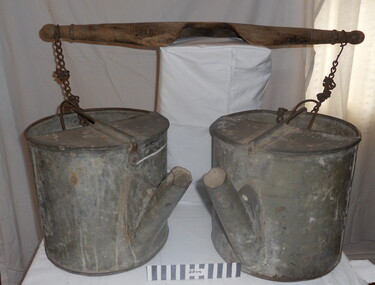
Tool - Chinese Market-Gardener's Watering-Cans
... A significant number of Chinese men, realising the potential of the sandy, fertile soil, with a good supply of water, in the Shire of Moorabbin, leased tracts of land in that area to establish a market garden and grow produce for the increasing population of Melbourne After the Dendy Special Survey in1841in Brighton, Victoria, the first sale of Crown Land, taking in the whole Shire of Moorabbin, occurred in 1852. These allotments ...Chinese market-gardener’s watering-cans on a wooden yoke. This item was authenticated by the Bendigo Historical Society, and is said to be quite rare. It consists of two large galvanized watering-cans each with a pouring spout, suspended by chains from a well-used wooden yoke. The cans would each have been filled with water, then carried a distance into the market garden and used to water crops. The cans and yoke alone are very heavy, one can only imagine how heavy they were when filled with water.As profits from the gold-fields petered out the Chinese immigrants, (nearly all single men), were forced to seek other occupations. Many moved into furniture building in the East Melbourne area, whilst others went into market gardening . A significant number of Chinese men, realising the potential of the sandy, fertile soil, with a good supply of water, in the Shire of Moorabbin, leased tracts of land in that area to establish a market garden and grow produce for the increasing population of MelbourneAfter the Dendy Special Survey in1841in Brighton, Victoria, the first sale of Crown Land, taking in the whole Shire of Moorabbin, occurred in 1852. These allotments of land were eagerly bought up - some by speculators - although many were either worked by the owner, or leased out as market gardens and "fruit gardens", (orchards). Chinese market-gardener’s watering-cans suspended by chains on a wooden yoke. This item was authenticated by the Bendigo Historical Society, and is said to be quite rare. It consists of two large galvanized watering-cans each with a pouring spout, suspended by chains from a well-used wooden yokebrighton, gardeners, bentleigh, orchards, vegetables, dendy henry, market gardens, chinese settlers, pioneers moorabbin, water wells, creeks -
 City of Moorabbin Historical Society (Operating the Box Cottage Museum)
Functional object - Butter churn domestic, circa 1800s
... From the mid 1800s into the1900s, there were numbers of Chinese market gardeners working in Bentleigh, Moorabbin, Mc Kinnon, and Cheltenham in the Shire of Moorabbin. After the sale of land following 'Dendy's Special Survey' 1841 many Chinese settlers rented allotments and established market gardens in the area and sold their produce to the increasing population of Melbourne at the markets in St Kilda and Melbourne. chinese melbourne brighton moorabbin butter cows milk pioneers dairy settlers fruit bentleigh markets mckinnon cheltenham vegetables dendy henry 'BUTTER CHURN' written in chalk undated, unsigned Circa late 1800s. ...Circa late 1800s. Wooden domestic butter-churn. This is a paddle churn, a barrel that contains a paddle, which is operated by a handle. The paddle churned the butter inside the container when the handle was turned. Early settlers had to be self sufficient, growing their own vegetables, making tools and clothing and usually had a house cow to produce their milk supply. An unsigned note states it was used by a Chinese market-gardener’s family. From the mid 1800s into the1900s, there were numbers of Chinese market gardeners working in Bentleigh, Moorabbin, Mc Kinnon, and Cheltenham in the Shire of Moorabbin. After the sale of land following 'Dendy's Special Survey' 1841 many Chinese settlers rented allotments and established market gardens in the area and sold their produce to the increasing population of Melbourne at the markets in St Kilda and Melbourne.Circa late 1800s. Wooden domestic butter-churn consisting of a wooden barrel with a lid and a crank that manually turned a paddle inside to separate the butter fat from the butter milk 'BUTTER CHURN' written in chalk undated, unsignedchinese, melbourne, brighton, moorabbin, butter, cows, milk, pioneers, dairy, settlers, fruit, bentleigh, markets, mckinnon, cheltenham, vegetables, dendy henry -
 City of Moorabbin Historical Society (Operating the Box Cottage Museum)
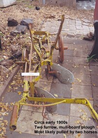
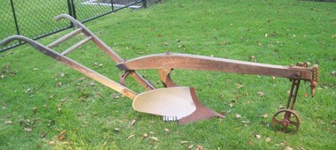
Tool - Farm Machinery, Horse-drawn Furrow Plough, Early 20th Century
... were bought by pioneer settlers who established or rented allotments for market gardens in the area. They supplied produce to the markets in St Kilda and Melbourne. ... were bought by pioneer settlers who established or rented allotments for market gardens in the area. They supplied produce to the markets in St Kilda and Melbourne. ...Late 1800s-early 1900s A horse-drawn furrow plough is an example of the type of farm implement widely used by pioneer market gardeners in the Moorabbin Shire following 'Dendy's Special Survey' of 1841 and the Crown Land Sale in 1852. Land allotments were bought by pioneer settlers who established or rented allotments for market gardens in the area. They supplied produce to the markets in St Kilda and Melbourne. During the gold-rush of the 1850s the rapidly increasing population of Melbourne saw a huge demand and a rise in prices for all foodstuffs, including the vegetables and fruit grown in the Shire of Moorabbin. This heralded a time of prosperity for market gardeners, and an equally rapid expansion of the numbers of vegetable and produce growers in the area. The 'knock-on effect" resulted in an increased interest and development of the community in the Shire of Moorabbin.Following 'Dendy's Special Survey' of 1841 and the Crown Land Sale in 1852, land allotments were bought by pioneer settlers who established or rented allotments for market gardens in the area and they supplied produce to the markets in St Kilda and Melbourne. During the gold-rush of the 1850s the rapidly increasing population of Melbourne saw a huge demand and a rise in prices for all foodstuffs, including the vegetables and fruit grown in the Shire of Moorabbin. Circa late 1800's to early 1900s. A horse-drawn furrow plough was the most common type of agricultural implement used by the pioneers of the 1800s and continued on into the 1940s when motorised tractors came into use. This plough is an example of a two furrow, mullboard plough which would most likely have been pulled by two horses. The long handle was used to lower the silver plates, (mullboards), to the chosen depth of soil. Painted yellow. Although this Box Cottage museum plough is unbranded, the most widely used plough in the Shire of Moorabbin was made by Oliver. This plough appears to be identical to that brand. brighton, moorabbin, pioneers, fruit, bentleigh, vineyards, vegetables, plough, market gardens, plow -
 City of Moorabbin Historical Society (Operating the Box Cottage Museum)
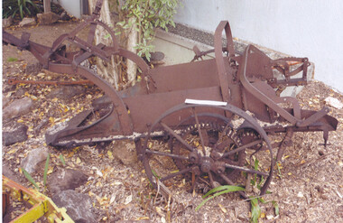
Tool - Farm Machinery, Horse-drawn Plough Potato Digger, c1900
... It is interesting to note that a group of Chinese market gardeners were the first to access the Sydney market. . Following the 'Dendy's Special Survey' 1841 and the Crown Land Sale of 1852, land allotments were sold to pioneer settlers who established market gardens in the area of Moorabbin Shire. ...Circa late 1800s early 1900s a horse-drawn plough, potato digger, is one example of the implements that were widely used by early market gardeners in the Shire of Moorabbin. The flat plate, seen to the right of the photo, dug down into the ground below the potatoes and "scooped" them up. Behind the plate, two driving chains on cogs, (these chains are missing from our exhibit), then "rocked' the dug potatoes to loosen the soil from the "spuds". The potatoes were then harvested by hand. Very large tracts of land in the Shire of Moorabbin were planted with potatoes. Harvesting commenced in October, into November and on into December. Potatoes were a necessary food staple. The market gardeners were always in a rush to be first to get their potatoes to market, and hence the best price. Some market gardeners were so keen to be the first to market, (and get the most money), that they dug their potatoes "green" (or new). The only downside of this practice was that these early potatoes had to be handled with extreme care as their skins were very loose, and came off easily - so decreasing their profits.As well as taking their produce to the Melbourne and St Kilda markets, they also sent produce off to Sydney markets. It is interesting to note that a group of Chinese market gardeners were the first to access the Sydney market. .Following the 'Dendy's Special Survey' 1841 and the Crown Land Sale of 1852, land allotments were sold to pioneer settlers who established market gardens in the area of Moorabbin Shire. During the 1850s gold-rush population boom the number of market gardeners increased significantly spreading throughout the Moorabbin Shire. Potatoes were considered a staple foodstuff, so crops were regularly sown throughout the whole Moorabbin area. Circa late 1800s early 1900s. A horse-drawn plough potato digger is an example of the machines used by early market gardeners in Moorabbin Shiremelbourne, sydney, markets, vegetables, potato, dendy henry, st kilda, market gardeners, gold rush, moorabin, chinese gardeners, ploughs -
 City of Moorabbin Historical Society (Operating the Box Cottage Museum)
Tool - Horse-drawn Metal Scoop Road-working
... Following the Dendy Special Survey 1841 allotments were sold to pioneer settlers who established market gardens in the Moorabbin area. ...This medium sized metal, horse-drawn, road-working scoop, with timber shafts is an example of those used in Moorabbin Shire in the late 1800s, and up until the 1940s for road-works, building dams, market-gardening work and other similar earthworks in the shire. The Box Cottage museum example would have been drawn by one horse, with the worker walking and steering the horse and scoop from behind using the timber shafts. There were even bigger metal scoops that required two or more horses to drag the scoop through the soil.Following the Dendy Special Survey 1841 allotments were sold to pioneer settlers who established market gardens in the Moorabbin area. Roads and roadside dams were needed as they transported both their stock and garden produce to markets in St Kilda and Melbourne By1880 the Shire of Moorabbin was using horse-drawn, road-working shovels on the main thoroughfares of the district.A medium sized metal, horse-drawn, road-working scoop, with timber shafts. Used by Moorabbin Shire in the late 1800s, and early 1900s for road-works, and other similar work in the shiremelbourne, shovel, brighton, moorabbin, metal, gardens, roads, markets, mckinnon, cheltenham, horse drawn, scoop, dendy henry, st kilda -
 City of Moorabbin Historical Society (Operating the Box Cottage Museum)
Machine - Farm Machinery, Plough, single mull-board, c1900
... were bought by pioneer settlers who established or rented allotments for market gardens in the area and they supplied produce to the markets in St Kilda and Melbourne. ...Circa late 1800's to early 1900s. A horse-drawn furrow plough was the most common type of agricultural implement used by the pioneer market gardeners, in Moorabbin Shire, of the 1800s and continued on into the 1940s when motorised tractors came into use. This plough is an example of a single-mullboard plough which would have been pulled by horse. The long handle was used to lower the silver plate, (mullboard), to the chosen depth of soil. Following 'Dendy's Special Survey' of 1841 and the Crown Land Sale in 1852, land allotments were bought by pioneer settlers who established or rented allotments for market gardens in the area and they supplied produce to the markets in St Kilda and Melbourne. During the gold-rush of the 1850s the rapidly increasing population of Melbourne saw a huge demand and a rise in prices for all foodstuffs, including the vegetables and fruit grown in the Shire of Moorabbin. An "Oliver" single mull-board plough in good condition with faded manufactures markings on shaftsPainted on shaft "MANF'D BY/OLIVER CHILLED PLOW WORKS/Southend Ind. USA/" Engraved on blade " 13 OLIVER"brighton, moorabbin, plough, dendy henry, east bentleigh, market gardens, horse drawn plough, plow, mullboard -
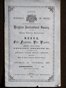 City of Moorabbin Historical Society (Operating the Box Cottage Museum)
Booklet - Schedule Booklet, horticultural prizes, "1879 Schedule of Prizes Brighton Horticultural Society", 1879
... Garden. This booklet is kept in the same cabinet as the Robert Key's Silver Trophy. After Henry Dendy's Special Survey in 1841 allotments of land were sold or rented to pioneer settlers who developed market gardens , fruit gardens and poultry farms in the Brighton area. ...This booklet from 1879 was given to the Moorabbin Historical Society when the Robert Keys Leader Cup Trophy, 1882-1883 was re-discovered at 'Box Cottage' Museum in 2009. The Leader Cup Trophy, MAV 00001, is also itemised in this booklet (p9) The Leader Newspaper offered the 'Silver Cup, value Five Guineas for the best fruit garden in the Brighton District. The Proprietors of the English, Scottish and Australian Chartered Bank offered an second prize of three Guineas Commencing in 1856, the Brighton Horticultural Society only disbanded in 2009, and most of their archival holdings were given to the Brighton Historical Society. This booklet gives a good idea of the large varieties of plants, poultry and the skills of the pioneer settlers of the Brighton District.This Booklet describes the Schedule of Prizes for the 1879 Grand Annual Exhibition of the Brighton Horticultural Society in Brighton Victoria. The Booklet was donated to the Moorabbin Historical Society in 2009 upon the disbanding of the Brighton Horticultural Society..at that time. The Moorabbin Historical Society possesses the 1882 'Leader Cup Trophy' (cat 00001) presented to Robert Keys for the best Fruit Garden. This booklet is kept in the same cabinet as the Robert Key's Silver Trophy. After Henry Dendy's Special Survey in 1841 allotments of land were sold or rented to pioneer settlers who developed market gardens , fruit gardens and poultry farms in the Brighton area. Their produce was sold at the St Kilda and Melbourne Markets for the growing population of MelbourneBooklet with mauve paper cover and 16 pages listing the Schedule of prizes for the 1879 annual exhibition of the Brighton Horticultural Society to be held in Brighton, Victoria."1879/ SCHEDULE OF PRIZES/OFFERED FOR COMPETITION BY THE/ BRIGHTON HORTICULTURAL SOCIETY,/ AT THEIR/ GRAND ANNUAL EXHIBITION/ OF / ROSES,/ CUT FLOWERS, POT PLANTS,/ FRUITS, VEGETABLES,/ POULTRY, PRODUCE, &c.,/TO BE HELD IN THE/ ARTILLERY PARADE GROUND, CRESCENT, / BRIGHTON,/ Near the North Brighton Railway Station, / ON / SATURDAY, 8th NOVEMBER, 1879./ ADMISSION 1s. / Doors open at 2 o'clock. / Brighton: / G. H. ORFORD, MACHINE PRINTER, NEXT NORTH BRIGHTON STATION. / 1879 ;melbourne, keys robert, trophy, leader newspaper, leader cup, brighton, silver, moorabbin, bentleigh, markets, dendy henry, st kilda, bent thomas, market gardens, brighton horticultural society, fruit gardens, banks chartered -
 City of Moorabbin Historical Society (Operating the Box Cottage Museum)
Clothing - Clothing, baby's long dress pin-tucked, c1900
... City of Moorabbin Historical Society (Operating the Box Cottage Museum) Joyce Park Jasper Road Ormond melbourne This long, white cotton pin-tucked baby's dress is an example of the clothing the women of pioneer settlers and market gardeners in Moorabbin Shire made for their families After the 1841 Dendy Special Survey of Brighton, Victoria, allotments of land were rented or sold to pioneer settlers. ...This long, white cotton pin-tucked baby's dress is an example of the clothing the women of pioneer settlers and market gardeners in Moorabbin Shire made for their familiesAfter the 1841 Dendy Special Survey of Brighton, Victoria, allotments of land were rented or sold to pioneer settlers. These settlers had to be self reliant and the women made most of the clothing for their families. This garment is one of the examples of the skills and craftsmanship of these women.A white, cotton, pin-tucked, long Baby's dress c 1900clothing, brighton, moorabbin, dressmaking, dendy henry, market gardeners, pioneer settlers, craft working