
Showing 11 items matching " gardenia road"
-
 Glen Eira Historical Society
Document - LEMPRIERE’S PADDOCK
... ... Gardenia Road...Gardenia Road, Gardenvale, Victoria, Australia...Lempriere’s Paddock Martin Street ‘Lempriere Estate’ Stewart Mary Cole Street Gardenia Road Polo grounds Gardenvale Railway Station North Road Nepean Road Magnolia Road Cochrane Street Gardenvale Document LEMPRIERE’S PADDOCK ...2 items about this location 1/Handwritten (3 pages) and typed duplication (2 pages) of notes on Lempriere’s Paddock and Estate 1902 -1928 by Mary Stewart. She grew up there with recollections including polo and gypsy encampments. 2/Handmade map of Lempriere Estate, subdivided circa 1910.lempriere’s paddock, martin street, ‘lempriere estate’, stewart mary, cole street, gardenia road, polo grounds, gardenvale railway station, north road, nepean road, magnolia road, cochrane street, gardenvale -
Glen Eira Historical Society
Document - GARDENVALE
... ... Gardenia Road...Gardenvale Bent Thomas Brighton Caulfield Elsternwick Railway stations Lempriere family ‘Bentville’ Lempriere’s Paddock Market gardens Nepean Highway Nepean Road North Road Kooyong Road Polo Sheridan family Bluestone houses Bethlehem Hospital Land subdivision Begonia Street Gardenia Road Gardenia Street Magnolia Street Lantana Street Martin Street Shops ‘Ben Burb’ House names Padua Hospital Brighton O’Neill Miss O’Neill College O’Neill Richard O’Neill Estate Elster Avenue O’Neill College Estate Railway Crescent Denver Crescent Brentani Avenue College Street Rosstown Railway Brighton Cemetery Ross Mr Hawthorn Road Ormond Gardenvale Progress Association Elster Creek Parliamentary representatives Landscapes Gardenvale Road Railway lines Subways Traders Association Drainage Floods Document GARDENVALE ...This file contains two items about Gardenvale, which was previously all part of Caulfield: 1/Photocopied eight page document by M. Stewart, 1961, entitled ‘The Gardenvale Story’. It describes Gardenvale Railway and surrounding roads and land. Lempriere’s Paddock, rail tracks on the main roads for the use of market gardeners’ wagons. Sale of land for O’Neill College Estate and construction of a subway through the railway embankment to Gardenvale Shopping centre, including efforts by local people and the council for work to be completed and costs. Footnote is circa 1977. 2/Map of Glen Eira printed from Council website 20/06/2014 showing Glen Eira’s share of Gardenvale.gardenvale, bent thomas, brighton, caulfield, elsternwick, railway stations, lempriere family, ‘bentville’, lempriere’s paddock, market gardens, nepean highway, nepean road, north road, kooyong road, polo, sheridan family, bluestone houses, bethlehem hospital, land subdivision, begonia street, gardenia road, gardenia street, magnolia street, lantana street, martin street, shops, ‘ben burb’, house names, padua hospital, brighton, o’neill miss, o’neill college, o’neill richard, o’neill estate, elster avenue, o’neill college estate, railway crescent, denver crescent, brentani avenue, college street, rosstown railway, brighton cemetery, ross mr, hawthorn road, ormond, gardenvale progress association, elster creek, parliamentary representatives, landscapes, gardenvale road, railway lines, subways, traders association, drainage, floods -
Glen Eira Historical Society
Document - Gardenvale, Elster Avenue, 7
... ... Gardenia Road...Elster Avenue Gardenvale Magnolia Road Gardenia Road Mason Walter Poole Elliat Turvey Clifford P. ...This file contains 3 items: 1/A copy of a colour photograph of the exterior of 7 Elster Avenue, taken in 1982 by Peta Darke. Includes Richard and Caroline Darke. 2/Resarch notes concerning 7 Elster Ave. dated 30/05/2014, handwritten by Peta Darke. Briefly describes history of the house. 3/A list of directory entries dated 30/05/2014. By Peta Darke.elster avenue, gardenvale, magnolia road, gardenia road, mason walter, poole elliat, turvey clifford p., hrd e. j. miss, harding ian k., harding janet, harding susan, harding mark, harding murray, city of caulfield, gardenvale park, shels nell, darke richard, darke caroline, darke peta, parks and reserves, land use, brick houses -
 Friends of Westgarthtown
Painting, John Borrack, Ziebells, German Lane, South View, c. 1970s
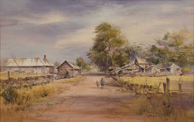
... Painted from Gardenia Road. The extensive farm complex on the right. ...Painted from Gardenia Road. The extensive farm complex on the right. ...Painted from Gardenia Road. The extensive farm complex on the right. (Western side of Gardenia Road). was demolished in 1972 for housing development. Buildings shown are cowshed, hay barn, engine shed and stables. Painted in the late afternoon, the lengthening shadows and lowering sky, could presage the ominous fate awaiting the farm with development. The Ziebell Farm was known as “The Pines†and sadly none of the many that proliferated there remain. Today they would be equivalent to those at the cemetery, having been planted at the same time. Provenance: John Borrack CollectionThese two paintings by acclaimed Victorian artist John Borrack, a direct descendant of the Ziebell family through his mother Augusta, hold substantial artistic, historical, and familial significance for Ziebell’s Farmhouse Museum and the broader Westgarthtown narrative. Borrack, recognised as one of Australia’s leading landscape painters, is known for his sensitive, precise and atmospheric depictions of place. His professional standing and artistic skill considerably elevate the cultural value of these works. The paintings depict Ziebell’s Farmhouse and the associated outbuildings on the opposite side of Gardenia Road, capturing the rural character of the property prior to subdivision and suburban encroachment. They function as accurate visual records of the farm’s earlier setting and the self-sufficient lifestyle. Their documentary value is amplified by Borrack’s own reflections: he explained that he made the original sketches in the 1950s and later, in the 1970s, “decided to make a positive record of what the farm looked like”, developing these paintings from those earlier drawings. One work shows the farmhouse and milking shed as seen from the cemetery: the other captures the view from the front garden toward the former vegetable garden. Their provenance deepens their significance. As works created by a Ziebell descendant who consciously sought to record his family heritage, the paintings embody intergenerational memory, personal connection, and the enduring legacy of the Ziebell family within Victoria’s cultural landscape. They enrich the museum’s interpretive capacity, offering rare artistic insight into the historic farmstead and contributing meaningfully to the preservation and understanding of Westgarthtown’s heritage. Watercolour depicting Ziebell Farmhouse from the north, Thomastown and Mernda. In gold frame with cream border.Artist signature: John Borrack; 70's Ziebells German Lane South Viewillustrations, watercolours, john borrack, ziebell, watercolour, painting -
 Whitehorse Historical Society Inc.
Legal record - Correspondence, Public Open Spaces, 24/12/1929 12:00:00 AM
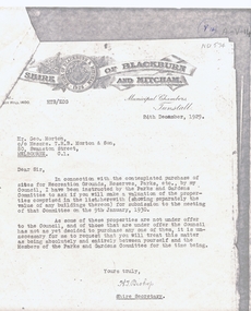
... ...gardenia street...husband road...land values shire of blackburn and mitcham bishop herbert thomas. morton george main street blackburn gardenia street husband road forest hill surrey road holland road blackburn south canterbury road whitehorse road nunawading glendale street williams road south parade tunstall Letter from H.T. ...Letter from H.T. Bishop, Shire Secretary, Shire of Blackburn and Mitcham to Mr Geo. Morton requesting valuation of landLetter from H.T. Bishop, Shire Secretary, Shire of Blackburn and Mitcham to Mr Geo. Morton requesting valuation of land for sale for the Parks and Gardens Committee, dated 24 / 12 / 1929. Valuations provided by Geo. Martin dated 6/ 1 / 1930.Letter from H.T. Bishop, Shire Secretary, Shire of Blackburn and Mitcham to Mr Geo. Morton requesting valuation of land land values, shire of blackburn and mitcham, bishop, herbert thomas., morton, george, main street, blackburn, gardenia street, husband road, forest hill, surrey road, holland road, blackburn south, canterbury road, whitehorse road, nunawading, glendale street, williams road, south parade, tunstall -
 Whitehorse Historical Society Inc.
Map, Blackburn Lake - Elmore houses walk, 1/11/1991
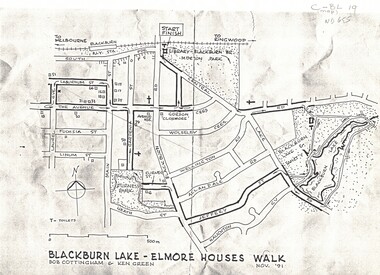
... ...gardenia street...blackburn road...maps blackburn lake sanctuary the avenue blackburn laburnum street main street gardenia street blackburn road gordon crescent Map of Blackburn outlining a walk through the lake. ...Map of Blackburn outlining a walk through the lake.Map of Blackburn outlining a walk through the lake. The route includes four Elmore houses.Map of Blackburn outlining a walk through the lake.maps, blackburn lake sanctuary, the avenue, blackburn, laburnum street, main street, gardenia street, blackburn road, gordon crescent -
 Friends of Westgarthtown
Painting, John Borrack, Last Days Ziebells "The Pines" Thomastown, c. 1970s
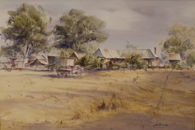
... The large pines beyond, sheltered the farmyard on the west of Gardenia Road. That complex can be partly glimpsed on the left of the painting. ...The large pines beyond, sheltered the farmyard on the west of Gardenia Road. That complex can be partly glimpsed on the left of the painting. ...Painted from the home (or front) paddock which ran south to the creek. The paddock was used for the cultivation of lucerne and maize crops in the lower regions while closer to the house where Ainwick Crescent is now situated, it was a burgeoning market garden for the cultivation of all varieties of vegetables. The large pines beyond, sheltered the farmyard on the west of Gardenia Road. That complex can be partly glimpsed on the left of the painting. This is a directly painted watercolour relying on the use of white paper and transparencies to impart a feeling of morning light. The figure is the artist's mother for whom the picture was painted. Provenance: Augusta Borrack (nee Ziebell) Collection, John Borrack CollectionThese two paintings by acclaimed Victorian artist John Borrack, a direct descendant of the Ziebell family through his mother Augusta, hold substantial artistic, historical, and familial significance for Ziebell’s Farmhouse Museum and the broader Westgarthtown narrative. Borrack, recognised as one of Australia’s leading landscape painters, is known for his sensitive, precise and atmospheric depictions of place. His professional standing and artistic skill considerably elevate the cultural value of these works. The paintings depict Ziebell’s Farmhouse and the associated outbuildings on the opposite side of Gardenia Road, capturing the rural character of the property prior to subdivision and suburban encroachment. They function as accurate visual records of the farm’s earlier setting and the self-sufficient lifestyle. Their documentary value is amplified by Borrack’s own reflections: he explained that he made the original sketches in the 1950s and later, in the 1970s, “decided to make a positive record of what the farm looked like”, developing these paintings from those earlier drawings. One work shows the farmhouse and milking shed as seen from the cemetery: the other captures the view from the front garden toward the former vegetable garden. Their provenance deepens their significance. As works created by a Ziebell descendant who consciously sought to record his family heritage, the paintings embody intergenerational memory, personal connection, and the enduring legacy of the Ziebell family within Victoria’s cultural landscape. They enrich the museum’s interpretive capacity, offering rare artistic insight into the historic farmstead and contributing meaningfully to the preservation and understanding of Westgarthtown’s heritage. Watercolour painting, depicting Ziebell's Farmhouse from the south (Thomastown and Mernda). Painting is mounted in a gold frame with cream board.Artist signature: John Borrack; Last Days at Ziebells "The Pines" Thomastown, 'Pro mea matre hanc picturan feci (In Memoria)'illustrations, watercolours, john borrack, ziebell, watercolour, painting -
 Brighton Historical Society
Uniform, WRANS uniform, 1942-1944
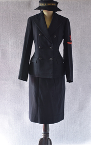
... Their family had been living in the district since 1892 when their grandfather, James Stewart, settled first at Brighton Beach before building a new home in Gardenia Road, Gardenvale in 1910. On leaving school, Marion took a job with the T&G Insurance Company in Collins Street. ...Their family had been living in the district since 1892 when their grandfather, James Stewart, settled first at Brighton Beach before building a new home in Gardenia Road, Gardenvale in 1910. On leaving school, Marion took a job with the T&G Insurance Company in Collins Street. ...This uniform belonged to Marion Elaine Caffrey, nee Bullock (1920-1993). Marion was born and lived in Begonia Road, Gardenvale and attended Star of the Sea College with her younger twin sisters, Hilary and Margaret Bullock. Their family had been living in the district since 1892 when their grandfather, James Stewart, settled first at Brighton Beach before building a new home in Gardenia Road, Gardenvale in 1910. On leaving school, Marion took a job with the T&G Insurance Company in Collins Street. However, as the threat of invasion by Japan loomed closer following the bombing of Pearl Harbour and the fall of Singapore, in 1943 she volunteered to join Australia's war effort as part of the Women's Royal Australian Naval Service (WRANS). She initially trained as a coder at HMAS Cerberus, followed by a posting to HMAS Magnetic in Townsville. By the time Marion arrived in Townsville in 1944 it was very much a garrison town, inhabited largely by Australian and American servicemen. Whereas in Melbourne the war in the Pacific may have felt somewhat distant, in Townsville it was very immediate. Though the town was never subjected to the heavy bombardments of Darwin, a series of small air strikes in July 1942 had made the fear of air raids quite real. The naval base HMAS Magnetic was responsible for communications, Port Examination Services and servicing of Allied warships. Marion worked as a coder, encoding outgoing transmissions and decoding incoming ones either manually or using a Typex cipher machine. In 1945, she completed additional training to attain the rank of Leading Coder. Her keenness for the work is evident in a note on her service record: although no WRANS women were ever sent to active warzones, Marion volunteered for overseas service. Marion later recalled her time with the WRANS as one of the happiest and most personally fulfilling times of her life. Like many Australian women, she embraced the opportunity to serve her country and take on roles traditionally reserved for men. She completed her three years' service at HMAS Harman in Canberra where she was de-mobbed in 1946. Afterwards, she secured a job with Metro Goldwyn Mayer, where she worked until her marriage to Hugh Caffrey in 1947.Second World War WRANS uniform consisting of a dark navy blue serge blazer (.1), skirt (.2) and hat (.3). The blazer features six buttons. The left arm features a black patch embroidered with a red anchor wrapped in a length of rope (a fouled anchor) with a single red chevron beneath, denoting the rank of Leading Wran (equivalent to Leading Seaman). The right arm features a black patch embroidered with red crossed flags over the letter 'C'. The pencil skirt is lined and fastens at the side with a button and snap fastenings. The navy felt hat features a round brim and a black ribbon band machine embroidered in gold with the words "H.M.A.S. HARMAN".Maker's label in collar of blazer reads "N491 / 1942 / SIZE [indistinct] / MADE IN AUSTRALIA" The label features a pen inscription, "BULLOCK". Size label in back of skirt: "2". Label inside the hat: "N18 / 1944 Size 20½ / MADE IN AUSTRALIA"1940s, marion elaine bullock, marion elaine caffrey, second world war, military uniform, wrans, women's royal australian naval service -
 Sunshine and District Historical Society Incorporated
Document - Kororoit Creek Interpretive Signage Proposal, Challisdesign, 2010
... 3148.01 - Kororoit Creek Interpretive Signage Proposal presented by Challis Design 1st June 2010 3148.02 - Kororoit Creek Interpretive Signage Proposal presented by Challis Design 22nd December 2010 3148.03 - Examples of interpretive signs Isabella Williams Reserve Deer Park : Bullum Bullum Reserve : Davitt Drive : Burnside Park : Black Powder Mill Cairnlea : Gardenia Place : Deer Park Hotel Watering Holes : More Park : Jones Creek and Market Gardens : Selwyn Park : Derby Road Sunshine : Arthur Beachley Reserve : Buckingham Reserve : Learmonth Crescent Sunshine : Proximity Drive Sunshine West : Home to River Red Gums : Remanants of the Native Grasslands : A Blend of the Old and New : Rich Evidence of Aborginal Occupation : Site of Significance : Riffle Habitat for Water Rates...Kororoit Creek 3148.01 - Kororoit Creek Interpretive Signage Proposal presented by Challis Design 1st June 2010 3148.02 - Kororoit Creek Interpretive Signage Proposal presented by Challis Design 22nd December 2010 3148.03 - Examples of interpretive signs Isabella Williams Reserve Deer Park : Bullum Bullum Reserve : Davitt Drive : Burnside Park : Black Powder Mill Cairnlea : Gardenia Place : Deer Park Hotel Watering Holes : More Park : Jones Creek and Market Gardens : Selwyn Park : Derby Road Sunshine : Arthur Beachley Reserve : Buckingham Reserve : Learmonth Crescent Sunshine : Proximity Drive Sunshine West : Home to River Red Gums : Remanants of the Native Grasslands : A Blend of the Old and New : Rich Evidence of Aborginal Occupation : Site of Significance : Riffle Habitat for Water Rates Collection of documents on the Kororoit Creek Interpretive Signage Proposal Document Kororoit Creek Interpretive Signage Proposal Challisdesign ...3148.01 - Kororoit Creek Interpretive Signage Proposal presented by Challis Design 1st June 2010 3148.02 - Kororoit Creek Interpretive Signage Proposal presented by Challis Design 22nd December 2010 3148.03 - Examples of interpretive signs Isabella Williams Reserve Deer Park : Bullum Bullum Reserve : Davitt Drive : Burnside Park : Black Powder Mill Cairnlea : Gardenia Place : Deer Park Hotel Watering Holes : More Park : Jones Creek and Market Gardens : Selwyn Park : Derby Road Sunshine : Arthur Beachley Reserve : Buckingham Reserve : Learmonth Crescent Sunshine : Proximity Drive Sunshine West : Home to River Red Gums : Remanants of the Native Grasslands : A Blend of the Old and New : Rich Evidence of Aborginal Occupation : Site of Significance : Riffle Habitat for Water Rateskororoit creek -
Whitehorse Historical Society Inc.
Document, Frankcom's Paddock Blackburn, 1914
... road...south parade...main street...myrtle grove...laurel grove...laburnum street...the avenue...fuchsia street...view street...linum street...kings paddock...blackburn township estate...gardenia...t. r. b morton & son francoms paddock blackburn road blackburn canterbury road south parade main street myrtle grove laurel grove laburnum street the avenue fuchsia street view street linum street kings paddock blackburn township estate gardenia street 1914 Auction of 80 lots Auction of 80 lots at Frankcom's Paddock, Blackburn: Laburnum Street, Myrtle Grove, The Avenue, Fuschia Street, View Street Frankcom's Paddock Blackburn Document Document ...Auction of 80 lotsAuction of 80 lots at Frankcom's Paddock, Blackburn: Laburnum Street, Myrtle Grove, The Avenue, Fuschia Street, View StreetAuction of 80 lotst. r. b morton & son, francoms paddock, blackburn road, blackburn, canterbury road, south parade, main street, myrtle grove, laurel grove, laburnum street, the avenue, fuchsia street, view street, linum street, kings paddock, blackburn township estate, gardenia street, 1914 -
Whitehorse Historical Society Inc.
Map, Plan, 1939
... Road...Blackburn...Vine Street...Blackburn...South Parade...Blackburn...Laburnum Street...Blackburn...Main Street...Blackburn...Gardenia...Street names Parish of Nunawading Station Street Blackburn Railway Road Blackburn Vine Street Blackburn South Parade Blackburn Laburnum Street Blackburn Main Street Blackburn Gardenia Street Blackburn The Avenue Blackburn Fuschia Street Blackburn Linum Street Blackburn Plan of subdivision, part of crown portion 83A and 83, Parish of Nunawading, County of Bourke Plan of subdivision, part of crown portion 83A and 83, Parish of Nunawading, County of Bourke Plan Map Map ...Plan of subdivision, part of crown portion 83A and 83, Parish of Nunawading, County of BourkePlan of subdivision, part of crown portion 83A and 83, Parish of Nunawading, County of BourkePlan of subdivision, part of crown portion 83A and 83, Parish of Nunawading, County of Bourkestreet names, parish of nunawading, station street, blackburn, railway road, blackburn, vine street, blackburn, south parade, blackburn, laburnum street, blackburn, main street, blackburn, gardenia street, blackburn, the avenue, blackburn, fuschia street, blackburn, linum street, blackburn
