Showing 9 items matching " gravel heaps"
-
 Linton and District Historical Society Inc
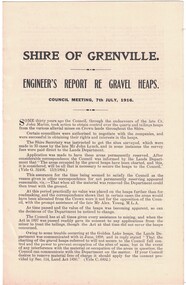
Report, Shire of Grenville, Engineer's Report re Gravel Heaps, 7th July 1916
... Shire of Grenville, Engineer's Report re Gravel Heaps, 7th July 1916...... Gravel heaps.... / ENGINEER'S REPORT RE GRAVEL HEAPS. / COUNCIL MEETING, 7th JULY, 1916...Shire of Grenville, Engineer's Report re Gravel Heaps, 7th July 1916 Report ...Single sheet approximately A4 in size, folded to form four pages. Three-page report prepared by M. Martin, Shire Engineer, detailing the advisability of and legal basis for the Shire of Grenville retaining control of various quartz and tailing heaps (remnants of mining) located throughout the Shire.Text: " SHIRE OF GRENVILLE. / ENGINEER'S REPORT RE GRAVEL HEAPS. / COUNCIL MEETING, 7th JULY, 1916. "shire of grenville, gravel heaps, mining, roads -
 Rutherglen Historical Society
Image, 1994
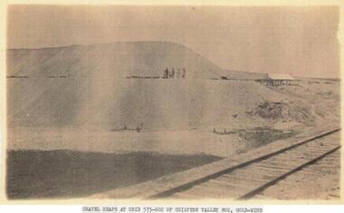
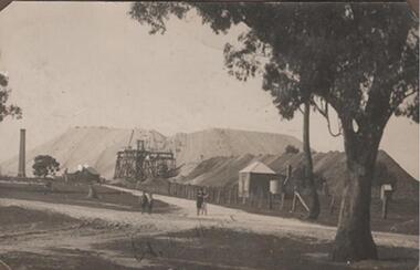
... Caption: "Gravel heaps at grid 575-602 of Chiltern Valley No. 2, Gold-Mine"...Rutherglen Historical Society Murray Street Rutherglen high-country chiltern valley mining industry gold mines gold mining Caption: "Gravel heaps at grid 575-602 of Chiltern Valley No. 2, Gold-Mine" One of two sepia coloured photographs, photocopied on A4 paper. ...One of two sepia coloured photographs, photocopied on A4 paper. Photographs copied either way up. Each has a typed caption.Caption: "Gravel heaps at grid 575-602 of Chiltern Valley No. 2, Gold-Mine"chiltern valley, mining industry, gold mines, gold mining -
 8th/13th Victorian Mounted Rifles Regimental Collection
Phptograph
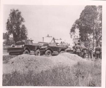
... Black and white photograph of two Doodlebug Scout Cars behind gravel heaps. Group of soldiers standing to rlght of photograph.One of a collection of photographs of 8th/13th Victorian Mounted Rifles Regiment between 1948 and 1951....Black and white photograph of two Doodlebug Scout Cars behind gravel heaps. Group of soldiers standing to rlght of photograph.One of a collection of photographs of 8th/13th Victorian Mounted Rifles Regiment between 1948 and 1951. ...The 8th/13th Victorian Mounted Rifles was raised as a regiment of the Royal Australian Armoured Corps on 1 May 1948 with Headquarters in Melbourne and squadrons in Sale, Benalla/Wangaratta and Albury. In 1955 Regimental Headquarters moved to Wangaratta and a second squadron was located at Albury. The Sale squadron transferred to 4th/19th Prince of Wales’s Light Horse. In 1977 8/13 VMR Regiment was reduced to an independent squadron A Squadron 8th/13th Victorian Mounted Rifles and in 1991 was linked with 4th/19th Prince of Wales’s Light Horse forming the VMR Squadron of that regiment.Unique collection of photographs showing the first years of an armoured regiment of the post-Second World War era Citizen Military Forces showing equipment, uniforms, training and social activity and some personalities.Black and white photograph of two Doodlebug Scout Cars behind gravel heaps. Group of soldiers standing to rlght of photograph.One of a collection of photographs of 8th/13th Victorian Mounted Rifles Regiment between 1948 and 1951.A Squadron nattering at ? -
 Rutherglen Historical Society
Photograph - Image, 1914-1920 (Approximate)
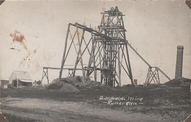
... It ceased production, machinery, chimneys & gravel heaps have disappeared....It ceased production, machinery, chimneys & gravel heaps have disappeared. "Garabaldi Mine - Rutherglen" Black & white photograph, unframed but pasted to pages of an album. ...Shows one of Rutherglen's largest gold mines taken at the time when they were fully productive. It ceased production, machinery, chimneys & gravel heaps have disappeared.Black & white photograph, unframed but pasted to pages of an album. Garibaldi Mine, Rutherglen"Garabaldi Mine - Rutherglen" -
 Rutherglen Historical Society
Photograph - Image, 1914-1920 (Approximate)
... It ceased production, machinery, chimneys & gravel heaps have disappeared....It ceased production, machinery, chimneys & gravel heaps have disappeared. "Great Southern" Black & white photograph, unframed but pasted to pages of an album. ...Shows one of Rutherglen's largest gold mines taken at the time when they were fully productive. It ceased production, machinery, chimneys & gravel heaps have disappeared.Black & white photograph, unframed but pasted to pages of an album. Great Southern"Great Southern" -
 Bendigo Historical Society Inc.
Photograph - CASTLEMAINE GAS COMPANY COLLECTION: PHOTO GAS AND FUEL DEPOT
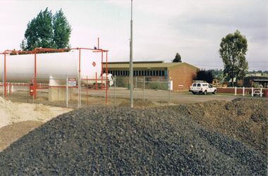
... Foreground is a large heap of gravel road base material...Foreground is a large heap of gravel road base material Photograph CASTLEMAINE GAS COMPANY COLLECTION: PHOTO GAS AND FUEL DEPOT ...Gas and Fuel depot with big gas tank. Centre background shows a large brick building with a row of windows just below roof line. White panel van is parked on righthand has red sign writing. Four white posts. Foreground is a large heap of gravel road base materialbusiness, retail, gas and fuel -
 Bendigo Historical Society Inc.
Slide - DIGGERS & MINING. GETTING THE GOLD, c1850s
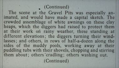
... Slide: (Continued) The scene at the Gravel Pits was especially animated, and would have made a capital sketch. The crowded assemblage of white awnings on these clay heaps, which the diggers had raised to protect them at their work on rainy weather, these standing at different elevations; the diggers turning their windlasses; and others, in rows of half-a-dozen along the sides of muddy pools, working away at their puddling tubs with their shovels, chopping and stirring them about; other cradling; others washing out. ...Slide: (Continued) The scene at the Gravel Pits was especially animated, and would have made a capital sketch. The crowded assemblage of white awnings on these clay heaps, which the diggers had raised to protect them at their work on rainy weather, these standing at different elevations; the diggers turning their windlasses; and others, in rows of half-a-dozen along the sides of muddy pools, working away at their puddling tubs with their shovels, chopping and stirring them about; other cradling; others washing out. ...Diggers & Mining. Getting the Gold. Slide: (Continued) The scene at the Gravel Pits was especially animated, and would have made a capital sketch. The crowded assemblage of white awnings on these clay heaps, which the diggers had raised to protect them at their work on rainy weather, these standing at different elevations; the diggers turning their windlasses; and others, in rows of half-a-dozen along the sides of muddy pools, working away at their puddling tubs with their shovels, chopping and stirring them about; other cradling; others washing out. (Continued) Markings: 34 994.LIF:4. Used as a teaching aid.hanimounteducation, tertiary, goldfields -
 Ballarat Heritage Services
Photograph - Colour Photograph, Clare Gervasoni, Mount Greenock, 2025, 28/06/2025
... gravels). A line of mine tailing and abandoned mining relics associated with the former Union Mine occur on the margins of the lava flow. Mount Greenock is a 120 hectare ‘Geological Reserve’, is one of the few large scoria cones on public land and contains abundant outcrop and morphological evidence of its volcanic origin. Mt Greenock Mount Greenock mining mullock heap ...Mt Greenock is an extinct volcano with lava flows associated with a deep lead. It is a tall scoria cone with a broad shallow crater open to the northwest. In the crater are blocks and bombs of scoriaceous basalt. Long lava flows extend both north and south from the cone. It is considered a significant geological site, and part of the Major Mitchell Trail, with a 1936 ‘Centenary of Major Mitchell ‘monument on the summit. The flow to the north has been eroded by McCallum Creek which is a lateral stream. On the eastern base of the cone, the stream valley exposes a lava flow and underlying sedimentary rocks. The lava flow and the scoria cone overlie the Greenock lead (a buried valley with auriferous gravels). A line of mine tailing and abandoned mining relics associated with the former Union Mine occur on the margins of the lava flow. Mount Greenock is a 120 hectare ‘Geological Reserve’, is one of the few large scoria cones on public land and contains abundant outcrop and morphological evidence of its volcanic origin. Colour Photographs of Mt Greenock, near Talbot, Victoria. The photographs were taken in winter not long after the first post drought rains. Mt Greenock was climbed by Major Thomas Mitchell on 26 September 1936, and he gave it the current name. At that time the mount was part of Alexander McCallum's Dunach Forest Pastoral Run.mt greenock, mount greenock, mining, mullock heap, mt greenock geological reserve, union mine, volcanic grasslands, dunach -
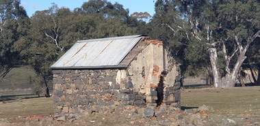 Ballarat Heritage Services
Photograph - Colour Photograph, Clare Gervasoni, Built Remains near Mount Greenock, 2025, 28/06/2025
... gravels). A line of mine tailing and abandoned mining relics associated with the former Union Mine occur on the margins of the lava flow. Mount Greenock is a 120 hectare ‘Geological Reserve’, is one of the few large scoria cones on public land and contains abundant outcrop and morphological evidence of its volcanic origin. Mt Greenock Mount Greenock mining mullock heap ...Mt Greenock is an extinct volcano with lava flows associated with a deep lead. It is a tall scoria cone with a broad shallow crater open to the northwest. In the crater are blocks and bombs of scoriaceous basalt. Long lava flows extend both north and south from the cone. It is considered a significant geological site, and part of the Major Mitchell Trail, with a 1936 ‘Centenary of Major Mitchell ‘monument on the summit. The flow to the north has been eroded by McCallum Creek which is a lateral stream. On the eastern base of the cone, the stream valley exposes a lava flow and underlying sedimentary rocks. The lava flow and the scoria cone overlie the Greenock lead (a buried valley with auriferous gravels). A line of mine tailing and abandoned mining relics associated with the former Union Mine occur on the margins of the lava flow. Mount Greenock is a 120 hectare ‘Geological Reserve’, is one of the few large scoria cones on public land and contains abundant outcrop and morphological evidence of its volcanic origin. Colour Photographs of bluestone and brick buildings at Mt Greenock, near Talbot, Victoria. The photographs were taken in winter not long after the first post drought rains. mt greenock, mount greenock, mining, mullock heap, mt greenock geological reserve, union mine, volcanic grasslands, dunach