Showing 369 items matching " griffiths street"
-
 Stawell Historical Society Inc
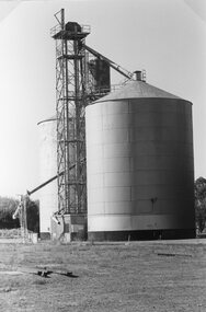
Photograph, Steel Grain Silo near Griffiths Street Stawell
... Steel Grain Silo near Griffiths Street Stawell...Steel Grain Silo railway line Near Griffiths Street...Stawell Historical Society Inc 46 Longfield St Stawell grampians Steel Grain Silo railway line Near Griffiths Street Stawell Steel Grain Silo near Griffiths Street Stawell Photograph ...Steel Grain Silo railway line Near Griffiths Streetstawell -
 Glen Eira Historical Society
Letter - Whittaker, G, Mrs
... ... Griffiths Street...Whittaker G Mrs Caulfield Flowers Street Council employees Caulfield council Chinese community Market gardens Quong Sing Bealiba Road Trams Bambra Road Glenhuntly Road Glen Huntly Road Pearce’s Nursery Nurseries Pearce Mr Prisoners Pearce Street Chloris Street Benbow family Griffiths Brothers teas Griffiths Street Longs Bull Paddock Long Mr Methodist Church Hawthorn Road Camden Town Methodist McConchie Harry McConchie Cricket II Glenhuntly Road Camden Court Freeman Street Lomax Frederick Chloris Park Letter Whittaker, G, Mrs ...File contains 2 items: 1/ A handwritten letter by Mrs G. Whittaker on her personal memories/recollections of South Caulfield, which includes neighbours’ transport, homes, businesses and properties, some of which may have been included in ‘Sand, Swamp and Heath’ by Murray and Wells. 2/ Handwritten research note dated 27/09/2013 by Peta Darke concerning Mrs Whittaker’s parents’ house.whittaker g mrs, caulfield, flowers street, council employees, caulfield council, chinese community, market gardens, quong sing, bealiba road, trams, bambra road, glenhuntly road, glen huntly road, pearce’s nursery, nurseries, pearce mr, prisoners, pearce street, chloris street, benbow family, griffiths brothers teas, griffiths street, longs bull paddock, long mr, methodist church, hawthorn road, camden town methodist, mcconchie harry, mcconchie cricket ii, glenhuntly road, camden court, freeman street, lomax frederick, chloris park -
 Port Fairy Historical Society Museum and Archives
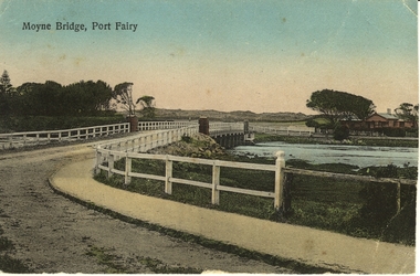
Photograph - Postcard, Moyne Bridge, Port Fairy
... Hand tinted photograph of Moyne river road bridge taken looking East showing house on Griffith street on the right side in the background taken for use as a Postcard...Port Fairy Historical Society Museum and Archives 30 Gipps Street Port Fairy great-ocean-road moyne bridge 1910 river road gipps street Moyne River, Port Fairy Hand tinted photograph of Moyne river road bridge taken looking East showing house on Griffith street on the right side in the background taken for use as a Postcard Moyne Bridge, Port Fairy Photograph Postcard ...Hand tinted photograph of Moyne river road bridge taken looking East showing house on Griffith street on the right side in the background taken for use as a PostcardMoyne River, Port Fairymoyne bridge, 1910, river, road, gipps street -
 Stawell Historical Society Inc
Photograph, Collins Brick Works in Griffith Street Stawell
... Collins Brick Works in Griffith Street Stawell...Collins Brick Works – Griffith Street Stawell...Stawell Historical Society Inc 46 Longfield St Stawell grampians Collins Brick Works – Griffith Street Stawell Stawell Industry Collins Brick Works in Griffith Street Stawell Photograph ...Collins Brick Works – Griffith Street Stawellstawell industry -
 Stawell Historical Society Inc
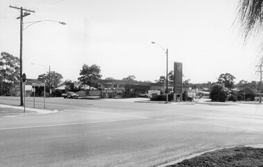
Photograph, Longfield & Griffith Streets Corner 1997
... Longfield & Griffith Streets 1997...Longfield & Griffith Streets 1997 Stawell Longfield & Griffith Streets Corner 1997 Photograph ...Street Scene - Cnr. Longfield & Griffith Streets 1997stawell -
Stawell Historical Society Inc
Photograph, Portrait of Benjamin Edhouse (Jnr)
... c1930's Brewers Laborer Stawell West 1854-1934. Lived in Griffith Street. Brother of Cr H Edhouse of Bryant's Brewery...Stawell Historical Society Inc 46 Longfield St Stawell grampians c1930's Brewers Laborer Stawell West 1854-1934. Lived in Griffith Street. Brother of Cr H Edhouse of Bryant's Brewery Portrait of Benjamin Edhouse (Jnr) Photograph ...c1930's Brewers Laborer Stawell West 1854-1934. Lived in Griffith Street. Brother of Cr H Edhouse of Bryant's Brewery -
 Stawell Historical Society Inc
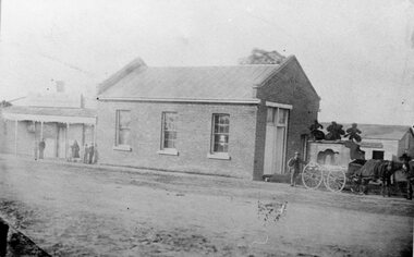
Photograph, Mr Frank Crouch -- Undertaker -- established 1862 on the corner of Longfield & Griffiths Streets
... Longfield Street & Griffiths Streets. Site later occupied by service station. ...Longfield Street & Griffiths Streets. Site later occupied by service station. ...F. Crouch (Established 1862) Cnr. Longfield Street & Griffiths Streets. Site later occupied by service station. Wooden building in background is a carpenters shop.stawell -
Glen Eira Historical Society
Article - Elster Avenue, 14, Elsternwick
... Street... Griffiths Lillian Mary...Elster Avenue Hinton Parnell Street College Street Kooyong Road Elsternwick Bowood Hartington Street Griffiths Lillian Mary Griffits Laura Margaret Cartwright Albert Costello Greg Canning Ed Canning Rae Canning Tom Canning Sam Barrett Jane Barrett Peter Morrissey James Morrissey Roxanne Clinch Christine St John’s Uniting Church Elsternwick Connolly Tim Connolly Louisa Connolly Scarlet Biggin and Scott Lempriere John Thompson Timber Houses Architectural styles Edwardian style Real Estate Agents Article Elster Avenue, 14, Elsternwick ...This file contains four items 1. Handwritten research notes dated 17/08/2013, by Peta Darke, concerning the history of 14 Elster Avenue, names ‘Hinton’. 2. 4 page brochure produced by Biggin and Scott for the house’s auction on 18/05/2013. Includes colour exterior and interior photographs and house plan. 3. Advertisement in “Property Review Weekly’, dated 26/04/2013, for the auction of the property on 18/05/2013. Includes colour exterior photograph. 4. Flyer with four colour photographs advertising forth coming auction of the property.elster avenue, hinton, parnell street, college street, kooyong road, elsternwick, bowood, hartington street, griffiths lillian mary, griffits laura margaret, cartwright albert, costello greg, canning ed, canning rae, canning tom, canning sam, barrett jane, barrett peter, morrissey james, morrissey roxanne, clinch christine, st john’s uniting church elsternwick, connolly tim, connolly louisa, connolly scarlet, biggin and scott, lempriere john thompson, timber houses, architectural styles, edwardian style, real estate agents -
 Greensborough Historical Society
Manuscript, Late Thoughts! by June Roberts, 1958-1978
... street...griffiths haberdashery...Also mentions the efforts needed to replace the Plenty River footbridge after it was washed away in a flood. main street shops tom vickers hume street griffiths haberdashery popes flintoff street plenty river bridge stubleys hardware stan ashleys menswear hume street residences rob willett ashril theatre Sept 78 in blue biro on front page. ...This was prepared by June Roberts with assistance from Grace Cavill. Written in 1978 it includes details of Greensborough's Main Street from circa 1958-1978.Describes the locations of the Main Street traders in the 1950s. Also mentions the efforts needed to replace the Plenty River footbridge after it was washed away in a flood.A 3 page typed manuscript and a hand drawn plan of Greensborough shopping area based on the document.Sept 78 in blue biro on front page.main street shops, tom vickers, hume street, griffiths haberdashery, popes, flintoff street, plenty river bridge, stubleys hardware, stan ashleys menswear, hume street residences, rob willett, ashril theatre -
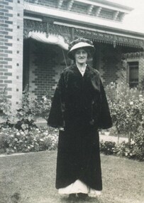 City of Ballarat Libraries
Photograph - Card Box Photographs, Mrs J.J. Griffiths, Ballarat circa 1895
... Griffiths...bodlyn...errard street...Griffiths stands out of the front of 'Bodlyn' situated at Errard Street North....J.J. Griffiths bodlyn errard street north building private dwelling Mrs J.J. ...Mrs J.J. Griffiths stands out of the front of 'Bodlyn' situated at Errard Street North.j.j. griffiths, bodlyn, errard street north, building, private dwelling -
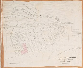
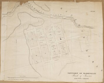 Bacchus Marsh & District Historical Society
Map, Maddingley Township, Parish of Parwan, County of Grant, 1856
... The main area of Maddingley shown on this map is an area bounded by Bacchus Street, Moore Street, Griffith Street and Franklin Street. Other streets visible are Inglis Street, Labilliere Street, McCrae Street. ...The main area of Maddingley shown on this map is an area bounded by Bacchus Street, Moore Street, Griffith Street and Franklin Street. Other streets visible are Inglis Street, Labilliere Street, McCrae Street. ...Maddingley is a locality or township within the broader township area of Bacchus Marsh. This map is dated 1856 but is based on an earlier survey in 1843. The main area of Maddingley shown on this map is an area bounded by Bacchus Street, Moore Street, Griffith Street and Franklin Street. Other streets visible are Inglis Street, Labilliere Street, McCrae Street. The area to the east of Franklin Street is not sub-divided and is described as an 'alluvial flat. A single page paper map showing land allotments, streets, and natural watercourses in the township of Maddingley. The map is pasted into a bound volume containing 76 maps or plans in total. Two inscriptions: 1. A.J. Skene Surveyor, 1843. ; 2. Surveyor-General's Office Melbourne, Sept 6, 1856. (Lithographed by R. Meikle)bacchus marsh victoria maps, maddingley victoria maps, land use, maddingley victoria history -
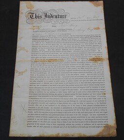 Bendigo Historical Society Inc.
Financial record - Abbott collection: Indenture from 1889
... Indenture made the 29th day of April, 1889 between James Craig of Newport and Henry Griffiths of Coppin Street Richmond. ...History House 11 Mackenzie Street Bendigo goldfields Indenture Financial record 1889 Indenture made the 29th day of April, 1889 between James Craig of Newport and Henry Griffiths of Coppin Street Richmond. ...Indenture made the 29th day of April, 1889 between James Craig of Newport and Henry Griffiths of Coppin Street Richmond. indenture, financial record, 1889 -
 Bacchus Marsh & District Historical Society
Map, Maddingley Township, Parish of Parwan, circa 1890s
... The main residential and commercial area of Maddingley is shown on this map in an area bounded by Bacchus Street, Barry Street, Griffith Street and Maddingley Road. Other streets visible are Franklin Street, Inglis Street, Labilliere Street, McCrae Street, Moore Street and part of Station Street....The main residential and commercial area of Maddingley is shown on this map in an area bounded by Bacchus Street, Barry Street, Griffith Street and Maddingley Road. Other streets visible are Franklin Street, Inglis Street, Labilliere Street, McCrae Street, Moore Street and part of Station Street. ...Maddingley is a locality or township within the broader township area of Bacchus Marsh. This map is not dated. However features in Maddingley which appeared in the 1880s and 1890s are present in the map, These include the Bacchus Marsh Railway Station and the Bacchus Marsh Showgrounds. The main residential and commercial area of Maddingley is shown on this map in an area bounded by Bacchus Street, Barry Street, Griffith Street and Maddingley Road. Other streets visible are Franklin Street, Inglis Street, Labilliere Street, McCrae Street, Moore Street and part of Station Street.A single page paper map showing land allotments, streets, rivers, creeks, park lands, the railway line and Bacchus Marsh railway station in the township of Maddingley. The map is pasted into a bound volume containing 76 maps or plans in total. bacchus marsh victoria maps, maddingley victoria maps, land use, maddingley victoria history -
![Map, Ballarat and Gordons Lane Plan of Land required [for railway line work]](/media/collectors/5e461d8021ea67224c82f2a1/items/676ff3a62c3783fe00b96a8d/item-media/676ff4a42c3783fe00b96cb6/item-fit-380x285.jpg?cb=6) Bacchus Marsh & District Historical Society
Bacchus Marsh & District Historical SocietyMap, Ballarat and Gordons Lane Plan of Land required [for railway line work]
... Single page map showing land required for railway line work near Griffith Street, Bacchus Marsh. Scale 10 chains to 1 inch. ...Bacchus Marsh Victoria History Maddingley Victoria History Railway Lines Single page map showing land required for railway line work near Griffith Street, Bacchus Marsh. Scale 10 chains to 1 inch. ...The railway line from Melbourne to Bacchus Marsh was completed in February 1887. After this date work continued to extend the line to Ballan. This map indicates a portion of land only a few hundred metres west of the Bacchus Marsh railway station which would have been among the first stages of the line to Ballan to have been constructed. This suggests the date of this map to be in the late 1880s.Single page map showing land required for railway line work near Griffith Street, Bacchus Marsh. Scale 10 chains to 1 inch. Hand-written on the map are the exact distances between Bacchus Marsh and Gordons (Gordon) and between Bacchus Marsh and Melbourne as measured from the corner of Maddingley Road and Station Street. Distances recorded are in miles, chains and links. The land required for the railway works is marked in red ink and runs through an area known as Kennedy's Gully. Part of a set of maps which are pasted into a bound volume containing 76 maps or plans in total. High resolution digital image stored on BMDHS computer network. bacchus marsh victoria history, maddingley victoria history, railway lines -
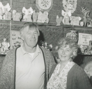 Lakes Entrance Historical Society
Photograph - Griffith's Shell Museum, Lakes Post Newspaper, 1/12/1995 12:00:00 AM
... This Shell Museum at 125 Esplanade Lakes Entrance was originally run by Coralie Griffiths parents in Laura Street Lakes Entrance ...Lakes Entrance Historical Society 4 Marine Parade Lakes Entrance gippsland This Shell Museum at 125 Esplanade Lakes Entrance was originally run by Coralie Griffiths parents in Laura Street Lakes Entrance Businesses Commerce Black and white photograph of Max and Coralie Griffiths of Griffiths Shell Museum with shell novelties on shelves, 125 Esplanade Lakes Entrance Victoria Photograph Griffith's Shell Museum Lakes Post Newspaper ...This Shell Museum at 125 Esplanade Lakes Entrance was originally run by Coralie Griffiths parents in Laura Street Lakes Entrance Black and white photograph of Max and Coralie Griffiths of Griffiths Shell Museum with shell novelties on shelves, 125 Esplanade Lakes Entrance Victoriabusinesses, commerce -
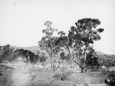 Stawell Historical Society Inc
Photograph, Pleasant Creek Cemetery 1866
... A memorial is located on the site of the One Tree Hill Cemetery, corner of Griffith and Leslie streets, Stawell West. ...A memorial is located on the site of the One Tree Hill Cemetery, corner of Griffith and Leslie streets, Stawell West. Stawell Pleasant Creek Cemetery 1866 Photograph ...Pleasant Creek Cemetery. Part of a collection of Photographs by Mr. O.G. Armstrong as commissioned by the Shire of Stawell for the Inter-colonial and Paris Exhibition in Melbourne in 1866. The site of the Pleasant Creek Cemetery was proclaimed on October the 14th, 1861. Prior to that, a cemetery existed on ‘One Tree Hill’ where burials were made as early as 1854. A memorial is located on the site of the One Tree Hill Cemetery, corner of Griffith and Leslie streets, Stawell West. stawell -
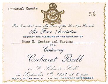 Bendigo Historical Society Inc.
Document - DOCUMENT - AIR FORCE ASSOCIATION CABARET BALL TICKET, 07/09/1951
... Also on the back is Mr & Mrs Ern Pritchard and Mr J Griffiths & Lady, 182 Victoria Street....Also on the back is Mr & Mrs Ern Pritchard and Mr J Griffiths & Lady, 182 Victoria Street. Document DOCUMENT - AIR FORCE ASSOCIATION CABARET BALL TICKET ...Cream coloured ticket with gold multi scallop edge. Printing dark blue. Gold emblem at the top. Ticket in the name of Miss E. Geotze and Partner and numbered 56. Ball held on September 7th, 1951 in St. Kilians's Hall. On the back Table No 21. Also on the back is Mr & Mrs Ern Pritchard and Mr J Griffiths & Lady, 182 Victoria Street.clubs, social, air force association, document, air force association cabaret ball ticket, miss e geotze and partner, air force association, mr & mrs ern pritchard, mr j griffiths and lady -
 Warrnambool and District Historical Society Inc.
Book, A Complete Epitome of Practical Navigation - J W Norie, 1848
... Street (south of Merri St) Warrnambool great-ocean-road This book is a 19th Century treatise on aids to navigation. It belonged to John Cowtan who held land near the Cassady's Bridge area in Caramut Road today (he was related to the Cassady family) and who is mainly important in the history of Port Fairy. Captain John Cowtan was a ship's master for John Griffiths ...This book is a 19th Century treatise on aids to navigation. It belonged to John Cowtan who held land near the Cassady's Bridge area in Caramut Road today (he was related to the Cassady family) and who is mainly important in the history of Port Fairy. Captain John Cowtan was a ship's master for John Griffiths and a Launceston entrepreneur and ship owner between 1839 and 1844. In 1847 he went into partnership with John Bland, establishing a merchant's business with riverside buildings at the Port Fairy wharf. He left Port Fairy in the 1860s. The date of John Cowtan's signature in this book is 1849 (certainly a very early one in our history) and inside the front cover he has written notes about the local weather, mainly as it affected sailing conditions in late 1849 and early 1850. These notes are of great historical interestThis book is of great interest because it belonged to a Port Fairy historical figure and because of the hand written weather notes inside the front cover. This is a hard covered, leather bound book of 680 pages. It contains printed text, illustrations, tables, maps and sketches. One page is torn Some pages are stained. J Cowtan 1849john cowtan, port fairy -
 Warrnambool and District Historical Society Inc.
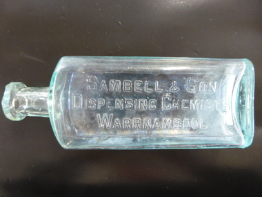
Bottle, Sambell & Son
... John Sambell opened the Hall of Pharmacy in Fairy Street, Warrnambool about 1890, taking over the business previously managed by Edward Griffiths. ...John Sambell opened the Hall of Pharmacy in Fairy Street, Warrnambool about 1890, taking over the business previously managed by Edward Griffiths. ...This bottle was used in the pharmacy of Sambell and Son of Warrnambool. John Sambell opened the Hall of Pharmacy in Fairy Street, Warrnambool about 1890, taking over the business previously managed by Edward Griffiths. Sambell was a chemist and dentist with previous business experience in England and Victoria. By 1919 John Sambell’s son, Herbert had joined the business, trading as Sambell and Son (though John Sambell had died in 1906) and the shop was located at 151 Fairy Street. The Sambells then built new shops on the north eastern corner of Koroit and Fairy Streets and occupied the corner position. In the late 1930s Sambells moved to 90 Fairy Street and the business became known as Sambell, Son and Granddaughter, with Herbert, the son, dying in 1943. This bottle is of considerable interest as one of the few items we have associated with the important Sambell family pharmacy business in Warrnambool. This is a glass bottle with a rectangular-shaped body with curved edges, a circular-shaped neck and a moulded circular top. The top is chipped and the inside of the bottle is a little discoloured. The name of the chemist is embossed on the front of the bottle. On base: ‘M’ On front of bottle: Sambell & Son, Dispensing Chemists, Warrnambool’ sambell,, warrnambool chemist, chemists in warrnambool, history of warrnambool -
 Warrnambool and District Historical Society Inc.
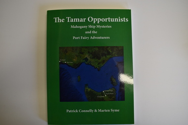
Book, The Tamar Opportunists - Mahogany Ship Mysteries and the Port Fairy Adventurers, 2022
... Warrnambool and District Historical Society Inc. 2 Gilles Street (south of Merri St) Warrnambool great-ocean-road This book, by Patrick Connelly and Marten Syme, re-assesses the Mahogany Ship legend and queries many aspects of the legend including the story of the 1836 whale boat wrecking that gave rise to the Mahogany Ship story. The book also gives historical information on five early Port Fairy personalities - John Griffiths ...This book explores aspects of the Mahogany Ship wreck and aspects of early Port Fairy history.This is a book of 122 pages. The cover is green with a green and blue map on the front and white printing on the front and back. It contains a Foreword and Acknowledgements, an Epilogue, Appendices, Bibliography, Index and printed material, maps, sketches, tables and black and white photographs.non-fictionThis book explores aspects of the Mahogany Ship wreck and aspects of early Port Fairy history.port fairy history, the tamar opportunists, mahogany ship -
 Warrnambool and District Historical Society Inc.
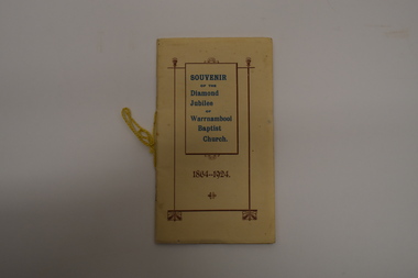
Booklet, Modern Print, Warrnambool, Souvenir of the Diamond Jubilee of Warrnambool Baptist Church, 1924
... Griffiths and then the Temperance Hall. The first regular pastor was the Rev. James Ewence and the first church in Koroit Street was opened in 1869, enlarged in 1874 and remodelled and extended in 1961....Warrnambool and District Historical Society Inc. 2 Gilles Street (south of Merri St) Warrnambool great-ocean-road This booklet is a souvenir production to celebrate the diamond jubilee of the Warrnambool Baptist Church. It gives details of the founding of the church and the subsequent 60 years, with the emphasis on the life and work of the ministers. Early services were held in the home of Mr and Mrs Andrew Griffiths ...History of the first 60 years of the Warrnambool Baptist ChurchThis is booklet of 32 pages. It has a buff-coloured cover with some ornamental scroll patterns and blue and gold printing. The pages contain printed text and black and white photographs. The pages have been bound with staples and tied with yellow cord but the staples have been removed.non-fictionHistory of the first 60 years of the Warrnambool Baptist Churchwarrnambool baptist church, baptist church 60 years warrnambool -
 Warrnambool and District Historical Society Inc.
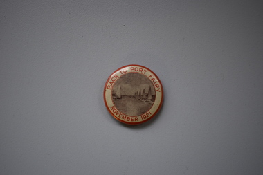
Badge, Back to Port Fairy, 1921
... Warrnambool and District Historical Society Inc. 2 Gilles Street (south of Merri St) Warrnambool great-ocean-road This badge was produced to celebrate a gathering of past and present residents at Port Fairy in 1921, with the event officially called ‘Back to Port Fairy’. Port Fairy is on the Princes Highway, 28 kilometres west of Warrnambool. By 1921 Europeans had settled in Port Fairy for about 85 years, with John Griffiths ...This badge was produced to celebrate a gathering of past and present residents at Port Fairy in 1921, with the event officially called ‘Back to Port Fairy’. Port Fairy is on the Princes Highway, 28 kilometres west of Warrnambool. By 1921 Europeans had settled in Port Fairy for about 85 years, with John Griffiths setting up a whaling station on Griffiths Island in 1836 and James Atkinson establishing the town area in the early 1840s. Atkinson called the town Belfast and it was known by this name until 1887 when the name reverted to Port Fairy. The Back to Port Fairy celebrations in 1921 ran from November 10th to November 19th. A month before, in October 1921, the Glaxo factory, a prominent business in Port Fairy for many years, had been established.This badge is of minor interest as a memento of a celebration at Port Fairy in 1921 and is retained for display purposes.This is a metal badge with red edging, red lettering and a grey-coloured image of boats at the Port Fairy wharf. Back to Port Fairy November 1921port fairy, history of warrnambool, badge, port fairy -
 Warrnambool and District Historical Society Inc.
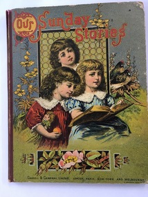
Book, Our Sunday Stories, 1880's
... The Warrnambool Baptist Church was established in 1864 in a small cottage in Kinross Avenue in Warrnambool at the home of Mr and Mrs Andrew Griffiths. In 1869 a church was built in Koroit Street and enlarged in 1974. ...Warrnambool and District Historical Society Inc. 2 Gilles Street (south of Merri St) Warrnambool great-ocean-road This book was a prize given by the Warrnambool Baptist Sunday School to Richard Petterd in 1888. The Warrnambool Baptist Church was established in 1864 in a small cottage in Kinross Avenue in Warrnambool at the home of Mr and Mrs Andrew Griffiths. ...This book was a prize given by the Warrnambool Baptist Sunday School to Richard Petterd in 1888. The Warrnambool Baptist Church was established in 1864 in a small cottage in Kinross Avenue in Warrnambool at the home of Mr and Mrs Andrew Griffiths. In 1869 a church was built in Koroit Street and enlarged in 1974. From time to time more improvements were made and the church still operates from the same site today. A Sunday School was established in 1865. Richard Forrester Petterd, born in 1878 in Warrnambool, was the son of George Petterd and Mary Ann Petterd, nee Warn. He married Susanna McConnell in 1903 and died in 1935. A daughter, Muriel, married Frederick Wooles in 1933 and it was their son, Kenneth from whose estate this book has come to be added to the Society’s collection.This book is most significant as it is a rare memento from the early days of the Warrnambool Baptist Sunday School and it belonged to Richard Petterd whose family was involved in businesses in Warrnambool as picture framers, stationery and fancy goods shop proprietors and estate commission agents. The book is a very attractive example of Victorian-era children’s books. This is a hard cover book of 80 pages It has a multi-coloured front cover depicting three children reading a book with a window behind them and floral decorations and two birds surrounding the three girls. The red binding is somewhat torn. The back cover has black and white etchings of flowers and children and advertisements for other books available. The book has several black and white drawings in grey tonings.‘Warrnambool Baptist Sunday School, Fourth Class United, Third Prize awarded to Richard Petterd, April 10th 1888.’warrnambool baptist church, richard petterd, kenneth wooles -
 Warrnambool and District Historical Society Inc.
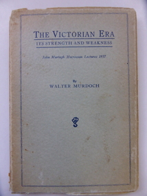
Book, The Victorian Era It's strengths & weaknesses, 1938
... Street (south of Merri St) Warrnambool great-ocean-road This book has been written by Walter Murdoch and it is the publication of two lectures given by Murdoch in 1937 (the John Murtagh Macrossan Memorial Lectures). John Murtagh Macrossan (1833-1891) was a Queensland politician who for some time held the seat of Townsville in the Queensland Parliament. He was born in Ireland and came to Australia in 1853, spending some time in the mining regions of Queensland. With Samuel Griffith ...This book has been written by Walter Murdoch and it is the publication of two lectures given by Murdoch in 1937 (the John Murtagh Macrossan Memorial Lectures). John Murtagh Macrossan (1833-1891) was a Queensland politician who for some time held the seat of Townsville in the Queensland Parliament. He was born in Ireland and came to Australia in 1853, spending some time in the mining regions of Queensland. With Samuel Griffith he attended the first National Convention on Federation in 1891. Walter Murdoch (1874-1970) had a distinguished academic career and became Australia’s best-known essayist. He was a household name to two generations of Australians through his radio broadcasts and syndicated literary columns in several Australian newspapers. In 1901 Walter Murdoch came to Warrnambool and went into partnership with James Scott as proprietors of a private school, Warrnambool College. They bought out Stanley’s Warrnambool Grammar School and when Scott retired Murdoch became the sole proprietor and Head Master of Warrnambool College. While in Warrnambool in 1903 Murdoch wrote a school history book called ‘The Struggle for Freedom’, a book which sold 10,000 copies in its first year. Murdoch later became an English lecturer at Melbourne University and then the foundation Professor of English at the University of Western Australia. Murdoch University in Western Australia is named after him. He published over 40 books and he was knighted in 1964. This book is of interest as it was written by Walter Murdoch. He not only has a national reputation as an academic and writer but also he spent some time in Warrnambool and played his part in our history. This is a soft cover book of 66 pages. The cover was originally blue but is much faded, especially on the spine. The print on the cover and spine is dark blue and there is an ornamental edging on the front cover. The back of the cover has an advertisement for other Walter Murdoch books. The pages of the book are stained and the binding on the spine has broken away. walter murdoch, john murtagh macrossan, history of warrnambool, warrnambool college (early 20th century) -
 Warrnambool and District Historical Society Inc.
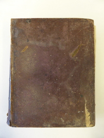
Book, The Domestic liturgy & family chaplain, 1846
... Street (south of Merri St) Warrnambool great-ocean-road This book belonged to John Cowtan. He was a purchaser of land near Cassady’s Bridge in Warrnambool and an important and early settler in Port Fairy. The land that John Cowtan selected, was bought by William Cassady whose sister, Ann, was married to John Cowtan. Cassady established the property, Boughton where Cassady’s Bridge is today. This book came from a Cassady estate sale early in the 21st century. Between 1839 and 1844 John Cowtan was a ship’s captain for John Griffiths ...This book belonged to John Cowtan. He was a purchaser of land near Cassady’s Bridge in Warrnambool and an important and early settler in Port Fairy. The land that John Cowtan selected, was bought by William Cassady whose sister, Ann, was married to John Cowtan. Cassady established the property, Boughton where Cassady’s Bridge is today. This book came from a Cassady estate sale early in the 21st century. Between 1839 and 1844 John Cowtan was a ship’s captain for John Griffiths, a ship owner and entrepreneur. In 1844, Cowtan established a merchant trading and produce business in Port Fairy with John Bland. In the 1860 John Cowtan went to live in Melbourne.This book is of great interest because of its early date (one year after the founding of Warrnambool) and because of its association with John Cowtan, a pioneer settler of Port Fairy with connections to Warrnambool.This is a brown leather covered book of 385 pages. The spine has gold lettering. The binding has come apart and has been mended with white cotton material on the inside of the cover. The insides of the cover have a brown, white, blue and yellow mottled pattern. The cover is stained and torn at the edges and has a deep gouging on the front. The first page has been torn and mended with tape and some of the pages are stained. There are two pressed fern fronds, one loose newspaper cutting and a bookmark with a sepia-coloured image, lace paper edges and coloured embroidery contained within the pages. The book has a preface and 58 chapters. The inscription is handwritten in black ink. ‘J. Cowtan 1848’ john cowtan, port fairy history, william cassady -
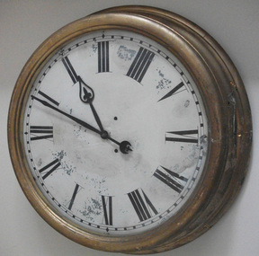 Warrnambool and District Historical Society Inc.
Functional object - Clock Sambell Chemist, Early 20th century
... Street, Warrnambool about 1890. He was a chemist and dentist with previous experience in Great Britain and Victoria. His shop had been conducted by Edward Griffiths in the 1880s. ...Street, Warrnambool about 1890. He was a chemist and dentist with previous experience in Great Britain and Victoria. His shop had been conducted by Edward Griffiths in the 1880s. ...This clock was over the door of the shop of Sambell’s pharmacy at 90 Fairy Street. John Sambell opened the Hall of Pharmacy in Fairy Street, Warrnambool about 1890. He was a chemist and dentist with previous experience in Great Britain and Victoria. His shop had been conducted by Edward Griffiths in the 1880s. By 1919 John Sambell’s son, Herbert, had joined the business, trading as Sambell and Son, though John Sambell had died in 1906. This shop was located at 151 Fairy Street. The Sambells then built new shops on the north eastern corner of Koroit and Fairy Streets and occupied the corner position. In the late 1930s the Sambell business moved to 90 Fairy Street and the business was known as Sambell, Son and Granddaughter. Herbert Sambell died in 1943. This Sambell clock had previously been at the shops of Brocks and Mainlands, both jewellers. This clock is of considerable importance as it was connected to the pharmacy business of the Sambell family, a business that was prominent in Warrnambool for many years. It is an example of the 19th and early 20th centuries practice of placing a large clock outside a business. This is a large oval clock with a gilded wooden frame and a metal face. The hour and second hands and the Roman figures are made of metal. The clock is designed to be placed on a wall or frame of some sort and to be used outside on a shop or other commercial building. The outside frame is somewhat dented.sambell pharmacy, warrnambool -
 Orbost & District Historical Society
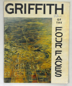
book, Riverina Commercial Press, Griffith, 1963
... Street Orbost gippsland Albert Jaime Grassby, AM was an Australian politician who served as Minister for Immigration in the Labor Whitlam Government. He completed reforms in immigration and human rights, and is often known as the father of Australian "multiculturalism". Prior to this Grassby worked as a journalist and information officer for the CSIRO in Griffith ...Albert Jaime Grassby, AM was an Australian politician who served as Minister for Immigration in the Labor Whitlam Government. He completed reforms in immigration and human rights, and is often known as the father of Australian "multiculturalism". Prior to this Grassby worked as a journalist and information officer for the CSIRO in Griffith, New South Wales.This item is a useful reference tool on the history of Griffith in New South Wales.A 46 pp paper back book titled, " Griffith of the Four Faces". on the front cover is a coloured aerial photograph of Griffith, New South Wales. The book contains coloured photographs and a history of the area.on front cover hand-written in blue pen - "M. Gilbert"griffith-new-south-wales griffith-history -
 Orbost & District Historical Society
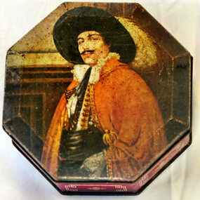
tin
... Orbost & District Historical Society Ruskin Street Orbost gippsland tin container Griffith's-sweets Underneath- Griffith Sweets Horsfall Printers Makers Richmond Octagonal shaped tin. ...Octagonal shaped tin. On the lid is a painting of a Spanish cavalier with red cape. The edges are dark red with rectangular patterns.Underneath- Griffith Sweets Horsfall Printers Makers Richmondtin container griffith's-sweets -
Ballarat Clarendon College
Book
... Ballarat Clarendon College 1425 Sturt Street Ballarat goldfields Books donated to the Ballarat College Library by Dr W R and Mrs Griffiths, Dr W R Griffiths and John Garland Griffiths. ...Books donated to the Ballarat College Library by Dr W R and Mrs Griffiths, Dr W R Griffiths and John Garland Griffiths. These are all members of the one family. John Garland griffiths entered ballarat College in 1938. [Family Links] Son of Mr W R & Dr Mary Skewes | [Family Links] Brother of Bruce, Margaret & David | [General] Previously at Winton College to Gr 4. Two books were donated in 1941 and a third in 1957. Three books of varying title and sizew-r-griffiths, dr-mary-skewes, john-garland-griffiths, ballarat-college, weatherly-library, 1941, 1957 -
Ballarat Clarendon College
Book, Various
... Ballarat Clarendon College 1425 Sturt Street Ballarat goldfields Presented to the school library in 1944 by Mr W Griffiths identity unconfirmed. ...Presented to the school library in 1944 by Mr W Griffiths identity unconfirmed. Example of ongoing commmunity support of the school. The Weatherly Library was opened in 1936 and its collection significantly established by donation or bequest of old collegians and members of the college community and associates.Four books/ The Andes and the Amazon - dark blue cloth bound book with gold lettering and illustration on cover and gold lettering on spine. Life of Gladstone 3 vols - red cloth binding with gold lettering on spine. Book plates inside cover: Book plate on flyleaf: Literature / Crest / Ballarat College / Library / Presented by / Mr W Griffiths 1944...