Showing 124 items
matching jackson?
-
 Stawell Historical Society Inc
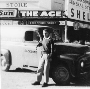
Photograph, Jacksons General Store Great Western and Delivery Van
Collected by Dorothy Brumby in relation to Great Western ResearchB/W photograph of man leaning against truck in front of Jacksons General StoreJacksons General Store -
 Hume City Civic Collection
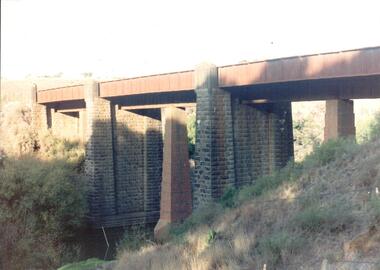
Photograph, Jacksons Creek Viaduct
The four arch railway bridge, known as the Jacksons Creek Viaduct Bridge, spans the Jacksons Creek north of the Sunbury Railway Station. The weir at the base of the bridge was used to dam water as well as ensuring a water supply for the steam trains. The pump house at the base of the bridge was where the water was pumped and then taken to the railway station for the steam engines.This bridge is one of notable four railway bridges along the railway line that are in Sunbury. An enlarged black and white photograph with a white border of a high bridge over a watercourse.bridges, jacksons creek viaduct, jacksons creek viaduct bridge, railways -
 Sunbury Family History and Heritage Society Inc.
Photograph, Jacksons Creek
The photograph of the waterfall tumbling over rocks in the Jacksons Creek are a feature downstream from the Macedon Street bridge and Craiglee when the there has been high rainfall. The steep escarpment on the LHS leads to Jacksons Hill and the line of trees in the distance are growing along Macedon Street (Sunbury Road).After heavy rainfall, Jacksons Creek rises suddenly and small trickles over the rocky outcrops become fast flowing waterfalls.A non-digital sepia photograph backed onto thick cardboard of a waterfall tumbling over rocks in a river with a high escarpment rising up from the watercourse. There are rocky outcrops across the hillside with a pipe down the hillside. jacksons creek, jackson hill, waterfalls, rivers -
 Warrnambool and District Historical Society Inc.
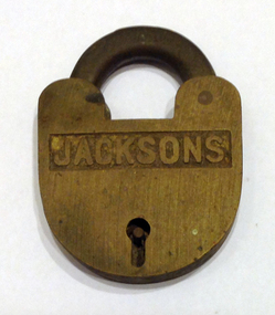
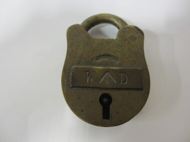
Functional object - Padlock
This padlock has been made by Jacksons Locks which is one of Australia’s oldest lock makers. Francis Jackson established the business in 1883 in Launceston, Tasmania and established a reputation for skilled craftsmanship and durable products. It is not known how the Historical Society acquired the item or who owned it,This lock has no known local connection but it is of interest as an example of an early lock. It may have been used to lock a sea trunk or an office building or a safe.This is a brass padlock in a half oval shape with a keyhole in the front and the locking mechanism at the top. This is open and there is no key with the item.Front of lock: ‘Jacksons’jacksons locks, tasmania, padlock -
 Hume City Civic Collection
Photograph
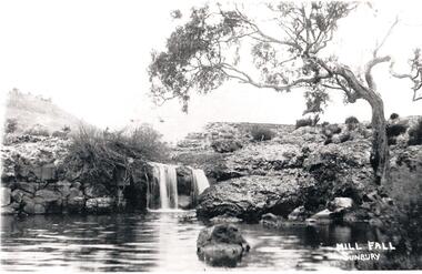
Eadie's Mill on Jacksons Creek was one of the earliest mills to be established in the area. Sunbury Waterworks now occupies the site.A black and white photograph of a small waterfall cascading over rocks into a waterhole in Jacksons Creek. It is near the ruins of Eadies Flour Mill, Sunbury, just up from the sewerage treatment plant.eadies flour mill, jackson creek, eadie, peter, waterfalls, george evans collection -
 Hume City Civic Collection
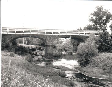
Photograph, late 1990s
The bridge constructed from bluestone, brick and iron over the Jacksons Creek at Sunbury is an important structure on the Melbourne-Echuca rail line. The foundation stone for the bridge was laid on 13 January 1859 and the bridge opened in July 1861. It is of state significance.A coloured photograph of the bluestone and iron railway bridge which is ove the Jacksons Creek. The bridge has 3 bluestone pylons and three iron pylons with 3 sections of the iron spans visible across the top.transport, bridges, rail transport, darbyshire, g. c., jacksons creek, george evans collection -
 Hume City Civic Collection
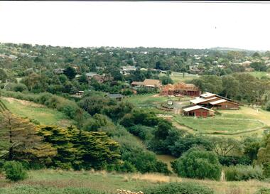
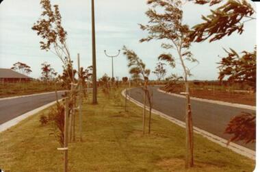
Photograph
Housing development spread to the banks of the Jacksons Creek at the east end of the town in the late 1970s.A coloured landscape photograph overlooking the Jacksons Creek and Sunbury township and showing housing development which is taking place on the horse shore bend also known as blueberry island on the opposite creek bank.jacksons creek, blueberry island, george evans collection -
 Hume City Civic Collection
Photograph, 1970s
The bluestone bridge which spans the Jacksons Creek was built in 1857 and replaced a laminated timber bridge. In the 1970s the stone bridge was replaced with a wider cement structure to accommodate the increased traffic flow.A black and white photograph of the bluestone Macedon road bridge over the Jacksons Creekmacedon street road bridge, harris, thomas lascelles, jacksons creek, george evans collection -
 Hume City Civic Collection
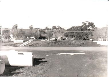
Photograph, Early 1970s
The two arch bluestone bridge which spanned the Jacksons Creek was replaced in the early 1970s with a wider double lane bridge. Dangerous curves were also taken out of the road. The area in the foreground on the RHS has now been incorporated into a public picnic area.A black and white photograph of road works taking place on the Sunbury Road over Jacksons Creek. Large concrete drain pipes are in the foreground and on the RHS of the photograph with roadwork signs on the LHS. Three trucks are at the foot of the hill.macedon street, macedon street road bridge, jacksons creek, road construction, george evans collection -
 Hume City Civic Collection
Photograph, 1/11/1980
On 4th August 1978 the construction of the Goonawarra Housing Estate commenced. The estate was formerly known as the Goonawarra Farm and overloked the Sunbury town area and Jacksons Creek valley. Plans for the new development included a gold course, housing, community and recreational facilities. The construction continued througout the last two decades of the twentieth century and into the twenty first century.A coloured photograph of Francis Boulevard at the Goonawarra Estate showing the entrances and landscaping and looking south to Sunbury Road and Jacksons Hill (Sheoak Hill).goonawarra farm, goonawarra golf club, goonawarra housing estate, kilkenny homes, craftsmen homes., australian ideas homes pty.ltd., villa bella homes, glamor homes, george evans collection -
Hume City Civic Collection
Pamphlet
This is a pamphlet about the Emu Bottom Wetlands where the platypus live and swim in Jacksons Creek. The Friends of Emu Bottom Wetlands is chiefly responsible for getting the Platypus Ponds Project going. They were established in 1974 under the auspices of the former Shire of Bulla to advise and assist in the reserves, preservation and protection of the platypus.A Small pamphlet about the local platypus.Platypus Ponds/on/Jacksons Creek/Sunburyplatypus, emu bottom wetlands, emu bottom, shire of bulla, jacksons creek, sunbury, hume city -
 Sunbury Family History and Heritage Society Inc.
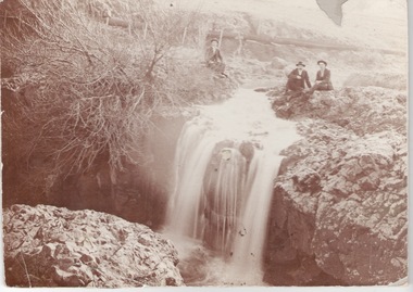
Photograph, c1910
The men are sitting above the waterfall and the Jacksons Creek close to the site of the former mill which utilised the water from the river to power the mill machinery.A sepia photograph mounted on cardboard of three men sitting on a river bank above a waterfall with a pipeline in the background.jacksons creek, sunbury -
 Sunbury Family History and Heritage Society Inc.
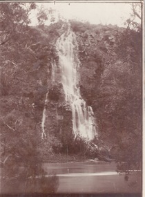
Photograph, c1920s
The waterfall is cascading down the Johnson Cliff which is on the Jacksons Creek downstream from Sunbury town.A sepia photograph with a narrow cream border mounted on cardboard of a waterfall cascading into the river below. johnsons cliff, jacksons creek, waterfalls -
 Sunbury Family History and Heritage Society Inc.
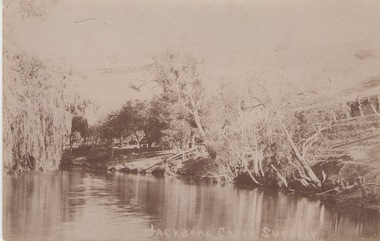
Photograph
The postcard features a view of the Jacksons Creek in Sunbury. Before settlement, Jacksons Creek was the main source of water in Sunbury. It flows from the Macedon Ranges and is an important arm of the Maribyrnong River. A sepia photograph in post card format of a view of a river in the country. JACKSONS CREEK SUNBURYjacksons creek, sunbury -
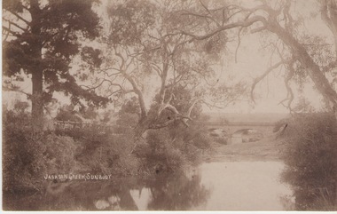 Sunbury Family History and Heritage Society Inc.
Photograph
The Jacksons Creek and the Macedon Street stone arched bridge are the features in this postcard with a view of a vineyard on the LH river bank. The wine industry was one of the early industries caroused out in Sunbury by the early European settlers in the district.A sepia photograph in post card format of a waterway with overhanging trees and an arched bridge in the middl;e distance.JACKSONS CREEK, SUNBURYjacksons creek, macedon street bridge, vineyards. -
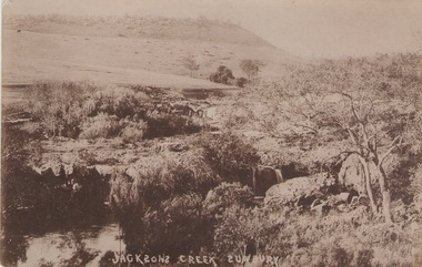 Sunbury Family History and Heritage Society Inc.
Photograph
he photograph was taken of Jacksons Creek near the waterfalls and weir which are downstream from Macedon Street.A sepia photograph in postcard format of a creek with the water tumbling over rocks. The land in the distance rises above the surrounding valley.JACKSONS CREEK SUNBURYjacksons creek, sunbury -
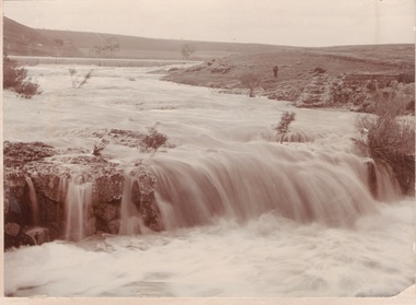 Sunbury Family History and Heritage Society Inc.
Photograph
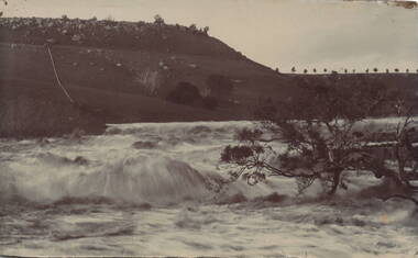
The waterfalls were on the Jacksons Creek downstream from Sunbury township and in the vicinity of a mill which was built on the river bank. The man standing on the riverbank on the RHS of the image is near the remains of Eadie's Mill which was one of the early structures erected in Sunbury.A sepia photograph mounted on a cream board of two waterfalls in a flooded river with bare hills on either side. A man is standing near some stone ruins on the RHS of the image.waterfalls, jacksons creek, mill falls -
 Sunbury Family History and Heritage Society Inc.
Photograph, 1935
The old weir constructed in the Jacksons Creek in Sunbury is featured in the photograph.A black and white photograph with a cream border of a waterfall tumbling over a built up rocky wall across the river.weirs, jacksons creek -
 Sunbury Family History and Heritage Society Inc.
Photograph, 1935
The waterfall is in Jacksons Creek downstream from the Sunbury township.A black and white photograph with a cream border of a waterfall in a river. A gnarled tree is growing on the bank and there is a hill in the middle distance.waterfalls, jacksons creek, sunbury -
 Gippsland Art Gallery
Painting, Dridan, David, Jacksons Creek near Richie Well, Nockatunga, 1983-84
Esso Collection of Australian Art. Donated by Esso Australia Pty Ltd, 2018Acrylic, Canvasgippsland, artwork, permanent collection -
 Warrnambool and District Historical Society Inc.
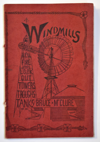
Work on paper - Booklet, Windmills: bell, fire and lookout towers, troughs, tanks
A catalogue of agricultural and engineering items manufactured and sold by Bruce and McLureRed soft cover A5 size booklet with hand-drawn image of a windmill, lookout tower and tank on the front cover; the back cover has text relating to Bruce & McClure's engineering works in Warrnambool. non-fictionA catalogue of agricultural and engineering items manufactured and sold by Bruce and McLure agriculture, windmills, engineering, bruce & mcclure -
 Waverley RSL Sub Branch
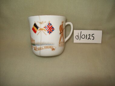
Cup
White cup (Jacksons Reg.643424 )Photo's printed around cup.of soldier and sailor ,2 pair of crossed flags.Words " Might in the right cause shall prevail." European War -
 J. Ward Museum Complex
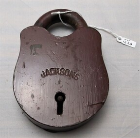
Functional object, Old Ararat Gaol - Padlock
This padlock provides conceptual knowledge regarding the padlocks used in Victorian goldfield gaols. Brass padlock under brown paint. Dents and scratches. No key. Open shackle. "JACKSONS" engraved in arch across keyhole. Smeared fingerprints in paint. gaol, prisoner, padlock -
 J. Ward Museum Complex
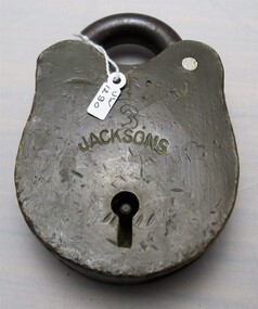
Functional object - Old Ararat Gaol - Padlock
The padlock is a good example of padlocks used in Victorian goldfield gaols. The padlock is significant in that it shows the wear and tear gaol equipment endured during the early days of European settlement. Old Ararat Gaol Brass Padlock "Jacksons" and "J" engravingsgaol, prison, padlock -
 Seaworks Maritime Museum
Lock
Small LockW D/ Jacksons -
 Federation University Historical Collection
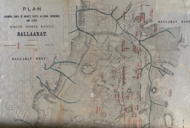
Plan, White Horse Range Ballarat, 1885, 06/1885
Two plans .1) Plan of the Ballarat Goldfields showing leads, rivers, streets and topography. Quartz reefs include: Yorkshire, Try Again, Promised Land, Western Slates, Norwegian, Robert's Lode, Finn's, Band and albion, Rothschild, Old Post Office, Queen Lode. Leads include: Navy jacks, Gays, Canadian, Prince Regent, Sailors Gully, White Horse, Little White Horse, Milkmans, Nightingale, Golden Point, Gravel Pits. Scale is 8 Chains to 1 inch .2) Plan showing lines of quartz reefs, alluvial workings and leads, White Horse Range, Ballarat. Leads include White Horse LEad, Little White Horse Lead, One Eye Gully, Terrible Lead, Sailor's Gully, Canadian Lead, Prince Regent Gully, Canadian Lead, Cavs Lead, Navy jacks Lead, Eureka Lead, Old Gravel Pits Lead, Gravel Pits Lead, Nightingale Lead, Malakoff Lead, Milkmans Lead, Redan Lead, Woolshed Lead, Jacksons Lead, Winters Lead, SCtochman's Lead, Canadian Lead. Reefs include: Promised Land, Daniash, Sir Garnet Wolsley, Norwegian, Rothschile, Band and Albion, Finns, Llanberis, Roberts Lode, Tynworths and Black Hill, Oregan, Yorkshire, Try Again, Yorkshire, Post Office, Clarke's, Western Slates, Black Slate, Danks Slates, Eastern Slates, Queen's Lode, Fire Brigade. Mines include Red Streak, New Chum, Tinworths, Woah Hawp, Normanby, Speedwell, Llanberris Extended, Llanberis, Last Chance, Major, Countess, Pioneer and a number of batteries along Main Road Hills include: Mount Clear, Pennyweight Hill, Sovereign Hillballarat, plan, white horse range, white horse, goldfields, mines, reefs, indicators, leigh river, cgt, tinworth, mining -
 Bendigo Historical Society Inc.
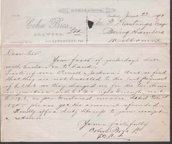
Document - COHN BROTHERS COLLECTION: HANDWRITTEN NOTE DATED 1891
Cohns Bros printed notepaper dated June 23rd 1891 addressed to E P Hastings handwritten re overcharging of Small & Jacksons account. Signed with initialls M H Cbendigo, industry, cohn bros brewery -
 Bendigo Historical Society Inc.
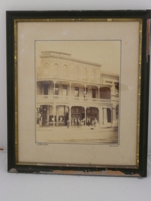
Photograph - JACKSONS CORNER. VIEW POINT. 1875, 1875
Black & white photo of 3 story building - Jacksons Corner at View point in Bendigo. 1 person on 2nd floor. 8 men & 2 young boys standing in front of building. Markings/Inscriptions: Jacksons Corner. View Point. Sandhurst about 1875.N. White. Photo. Sandhurst.place, building, public buildings -
 Bendigo Historical Society Inc.
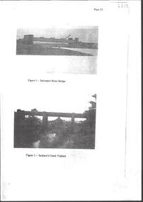
Photograph - RAILWAYS COLLECTION: RAILWAY BRIDGES AND VIADUCTS
RAILWAYS COLLECTION -6 x Unbound Photocopied double sided pages giving information on the construction of the Bendigo Railway Line including Black and white photos of Railway Bridges and Viaducts - which show the Saltwater River bridge , Jacksons Creek Viaduct, Riddell Creek Bridge, Campbell's Creek Road bridge, Forest creek viaduct and Malmsbury Viaduct the photos are grainy in appearance.photograph, landscape -
Clunes Museum
Book, The Victorian Municipal Directory and Gazeteer for 1888, 1888
Book contains information re; Municipal councils within Victoria, Arnall & Jacksons Almanac 1888, weather information, thirteenth Parliament of Vic., Ministries and Govt. Depts., Postal Rates, Waterworks Trusts, Railways, Harbour Trust, Certificates of Service, etc., & Advertisementsdirectory, victorian municipalities, 1888, arnall & jackson