Showing 32 items matching " kimbolton"
-
 Bendigo Historical Society Inc.
Map - KIMBOLTON, 24/05/1921
... KIMBOLTON......Kimbolton...Maqp: Kimbolton, County of Bendigo. Parish plan ( number 175 in Map Cupboard 1)...History House 11 Mackenzie Street Bendigo goldfields MAP Bendigo parish plan Kimbolton Maqp: Kimbolton, County of Bendigo. ...Maqp: Kimbolton, County of Bendigo. Parish plan ( number 175 in Map Cupboard 1)map, bendigo, parish plan, kimbolton -
Bendigo Historical Society Inc.
Map - KIMBOLTON, No date Visible
... KIMBOLTON......Kimbolton...Map: Kimbolton, County of Bendigo. Parish plan ( number 172 in Map Cupboard 1)...History House 11 Mackenzie Street Bendigo goldfields MAP Bendigo parish plan Kimbolton Map: Kimbolton, County of Bendigo. ...Map: Kimbolton, County of Bendigo. Parish plan ( number 172 in Map Cupboard 1)map, bendigo, parish plan, kimbolton -
Bendigo Historical Society Inc.
Map - KIMBOLTON, 20/12/1907
... KIMBOLTON......Kimbolton...Map: Parish of Kimbolton, County of Bendigo. Parish plan. ...History House 11 Mackenzie Street Bendigo goldfields MAP Bendigo parish plan Kimbolton Map: Parish of Kimbolton, County of Bendigo. ...Map: Parish of Kimbolton, County of Bendigo. Parish plan. (number 339 in map cupboard 1)map, bendigo, parish plan, kimbolton -
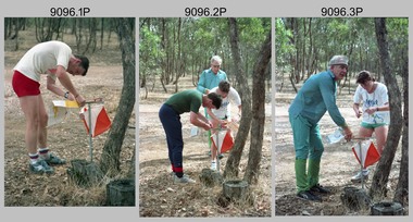 Bendigo Military Museum
Photograph - Army Inter-area Orienteering Competition, Kimbolton State Forest, VIC, 1990
... Army Inter-area Orienteering Competition, Kimbolton State Forest, VIC...This set of 29 photographs was taken during Army’s Inter-area Orienteering competition held in the Kimbolton State Forest, near Lake Eppalock, Victoria in 1990. ...This set of 29 photographs was taken during Army’s Inter-area Orienteering competition held in Kimbolton State Forest, near Lake Eppalock, Victoria in 1990. ...Army Inter-area Orienteering Competition, Kimbolton State Forest, VIC Photograph Army Inter-area Orienteering Competition, Kimbolton State Forest, VIC Army Survey Regiment ...This set of 29 photographs was taken during Army’s Inter-area Orienteering competition held in the Kimbolton State Forest, near Lake Eppalock, Victoria in 1990. Teams from Albury-Wodonga Bendigo, Broadmeadows, Melbourne Metropolitan, Puckapunyal and Watsonia participated in the annual competition. Bendigo’s Army Survey Regiment led by SGT Mick Minchin hosted the Orienteering events. This set of 29 photographs was taken during Army’s Inter-area Orienteering competition held in Kimbolton State Forest, near Lake Eppalock, Victoria in 1990. The colour photographs are on 35mm negative film and were scanned at 2400 dpi. They are part of the Army Survey Regiment’s Collection. .1) to .4) - Photo, colour, 1990, unidentified competitors. .5) - Photo, colour, 1990, L to R: unidentified competitor, Bendigo’s Janet Murray. .6) - Photo, colour, 1990, L to R: unidentified official, Le-Anne (Smallshaw) Shirley, Bendigo’s Janet Murray, unidentified competitors (x2). .7) to .8) - Photo, colour, 1990, unidentified competitors. .9) - Photo, colour, 1990, L to R: unidentified official, Mick Minchin. .10) to .11) - Photo, colour, 1990, Mick Minchin. .12) to .13) - Photo, colour, 1990, Bendigo’s Team L to R: Rene van den Tol, Wolfgang Hofbauer, Mick Minchin, Harris Lee, unidentified competitor, Allan Blake, Janet Murray. .14) & .15) - Photo, colour, 1990, presentations L to R: Rene van den Tol, unidentified competitor. .16) to .19) - Photo, colour, 1990, unidentified competitors. .20) - Photo, colour, 1990, presentations L to R: Rene van den Tol, unidentified competitor. .21) - Photo, colour, 1990, presentations L to R: Rene van den Tol, unidentified competitor, Mick Minchin. .22) - Photo, colour, 1990, BBQ L to R: unidentified (x2), Jeff Rudd, Rene van den Tol, Mick Minchin, Neville Stone, Steve Cooper. .23) - Photo, colour, 1990, BBQ, Wolfgang Hofbauer. .24) - Photo, colour, 1990, BBQ, Janet Murray - in black jacket. .25) - Photo, colour, 1990, BBQ, all unidentified. .26) - Photo, colour, 1990, BBQ, Neville Stone - in green t-shirt, Rene van den Tol in red track suit, remainder unidentified. .27) - Photo, colour, 1990, BBQ L to R: unidentified (x4), Janet Murray, Le-Anne (Smallshaw) Shirley, remainder unidentified. .28) & .29) - Photo, colour, 1990, views of Lake Eppalock.There are no personnel identified. ‘Inter-Area Orienteering 1990’ annotated on negative sleevesroyal australian survey corps, rasvy, army survey regiment, army svy regt, fortuna -
 Bendigo Historical Society Inc.
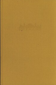
Book - KIMBOLTON, 1976
... KIMBOLTON...Kimbolton. History of a Victorian sheep station from its first settlement in 1838....Book KIMBOLTON ...Kimbolton. History of a Victorian sheep station from its first settlement in 1838.John Ormond Randellhistory, australian, early farming settlement, farming history. -
 Bendigo Historical Society Inc.
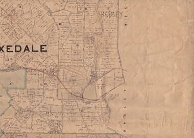
Map - Parish of Strathfieldsaye
... ...Kimbolton...Includes Axedale, Kimbolton, Eppalock and Sedgewick. Photographed/Lithographed for the Department of Lands and Survey Melbourne by T E McGauran 24.3.07. ...Includes Axedale, Kimbolton, Eppalock and Sedgewick. Photographed/Lithographed for the Department of Lands and Survey Melbourne by T E McGauran 24.3.07. ...Map owned by Henry Thomas (Jack) Qualtrough who worked for the Victorian Forestry Commission. Shire of Strathfieldsaye County of Bendigo canvas backed map. L5169. Includes Axedale, Kimbolton, Eppalock and Sedgewick. Photographed/Lithographed for the Department of Lands and Survey Melbourne by T E McGauran 24.3.07. Price 1/-.map, axedale, kimbolton, sedgewick, eppalock -
Bendigo Historical Society Inc.
Map - KIMBOLTON : COUNTY OF BENDIGO, 1966
... ...kimbolton...Map. Kimbolton, County of Bendigo. Eppalock, Lyell, Knowsley, Langwornor, Redesdale, County of Dalhouse, County of Rodney, Campaspe River, Coliban River,By authority A.C.Brooks, Government Printer, Melbourne. ...History House 11 Mackenzie Street Bendigo goldfields MAP Bendigo kimbolton A.C. Brooks, Government Printer, Melbourne. ...Map. Kimbolton, County of Bendigo. Eppalock, Lyell, Knowsley, Langwornor, Redesdale, County of Dalhouse, County of Rodney, Campaspe River, Coliban River,By authority A.C.Brooks, Government Printer, Melbourne. Drawn and reproduced at the Department of Lands and Survey, Melbourne, 1966, Price $1.00 (number 65 in map cupboard 1)A.C. Brooks, Government Printer, Melbourne.map, bendigo, kimbolton -
 Bendigo Historical Society Inc.
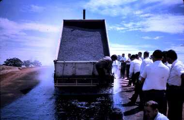
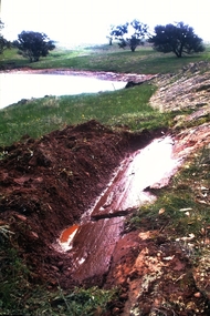
Slide - DAVID MCDONALD COLLECTION: EPPALOCK. CONSTRUCTION, c1963
... Markings: Launching of ramp road Kimbolton Pool. Eppalock March 1963....Markings: Launching of ramp road Kimbolton Pool. Eppalock March 1963. Slide DAVID MCDONALD COLLECTION: EPPALOCK. ...Eppalock. Construction. Laying bitumen down for the launching ramp at Kimbolton Pool. The men looking on appear to be all office workers (they have white shirts & ties). Markings: Launching of ramp road Kimbolton Pool. Eppalock March 1963.Kodakcivil engineering, water supply, eppalock -
Bendigo Historical Society Inc.
Map - CAMPBELL COLLECTION: BENDIGO AND DISTRICT MAPS
... Map. Kimbolton, Parishes of Kimbolton and Lyell, scale 20 chains to 1 inch. ...History House 11 Mackenzie Street Bendigo goldfields MAP Bendigo allotments Map. Kimbolton, Parishes of Kimbolton and Lyell, scale 20 chains to 1 inch. ...Map. Kimbolton, Parishes of Kimbolton and Lyell, scale 20 chains to 1 inch. Area by Planimeter 6258 acres. Knowsley. 10 1/2 miles to Strathfieldsaye. Campaspe River at bottom right of map. (number 365 in map cupboard 1)map, bendigo, allotments -
Bendigo Historical Society Inc.
Map - CAMPBELL COLLECTION: BENDIGO AND DISTRICT MAPS, 1929
... Campaspe, Parish of Kimbolton. Total area 4117 acres. Campaspe River, Kimbolton. ...Campaspe, Parish of Kimbolton. Total area 4117 acres. Campaspe River, Kimbolton. ...Map. Campaspe, Parish of Kimbolton. Total area 4117 acres. Campaspe River, Kimbolton. Scale 20 chains to 1 inch. Prepared in W.P.B. form Parish and Assessment Plans. G.W.L. 9-4-29. (number 351 in map cupboard 1)map, bendigo, allotments -
 Bendigo Historical Society Inc.
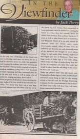
Newspaper - JACK PERRY COLLECTION: NEWSPAPERFIREWOOD INDUSTRY
... ... Kimbolton...Mentions Emu and Axe Creek, Kimbolton, Whipstick areas. Charcoal burners. ...Mentions Emu and Axe Creek, Kimbolton, Whipstick areas. Charcoal burners. ...Newspaper article, Bendigo Weekly, re firewood industry and use of wood in mines. Mentions Emu and Axe Creek, Kimbolton, Whipstick areas. Charcoal burners. Kurting, Inglewood and Argyle areas , Heathcote and railway sidings. Koefeds and Bendigo Preserving Company are companies mentioned . Image shows Koefeds motorized truck bringing in wood - also horse and cart loaded with wood.person, individual, jack perry, heathcote, california gully, axe and emu creeks, kimbolton, whipstick, charcoal, kurtging, inglewood, argyle. -
Bendigo Historical Society Inc.
Map - CAMPBELL COLLECTION: BENDIGO AND DISTRICT MAPS, 8-6 29
... Map. Kimbolton, Parishes of Kimbolton and Lyell, scale 20 chains to 1 inch. ...History House 11 Mackenzie Street Bendigo goldfields MAP Bendigo allotments G.W.Latimer Map. Kimbolton, Parishes of Kimbolton and Lyell, scale 20 chains to 1 inch. ...Map. Kimbolton, Parishes of Kimbolton and Lyell, scale 20 chains to 1 inch. Area by Plamimeter 6258 acres. Coliban River, Knowsley, Strathfieldsaye 10 1/2 miles. Prepared in W.P.B. from Parish and Assessor's Plans. G.W.Latimer 8-6-29. (number 393 in map cupboard 1)G.W.Latimermap, bendigo, allotments -
 Greensborough Historical Society
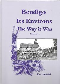
Book, Crown Castleton Publishers, Bendigo Its Environs - the Way it Was. Vol 3 / by Ken Arnold, 2013_
... A brief history of the areas of Strathfieldsaye, Junortoun, Longlea, Axedale, Kimbolton, Redesdale, Lyal, Myrtle Creek, Axe Creek, Eppalock, Emu Creek, Sedgwick, Mandurang, Mandurang South and Diamond Hill....Greensborough Historical Society 34A Glenauburn Road Lower Plenty Lower Plenty melbourne A brief history of the areas of Strathfieldsaye, Junortoun, Longlea, Axedale, Kimbolton, Redesdale, Lyal, Myrtle Creek, Axe Creek, Eppalock, Emu Creek, Sedgwick, Mandurang, Mandurang South and Diamond Hill. bendigo 399 pages, illus. ...A brief history of the areas of Strathfieldsaye, Junortoun, Longlea, Axedale, Kimbolton, Redesdale, Lyal, Myrtle Creek, Axe Creek, Eppalock, Emu Creek, Sedgwick, Mandurang, Mandurang South and Diamond Hill.399 pages, illus. Hard cover.bendigo -
Bendigo Historical Society Inc.
Map - BENDIGO (COUNTY), Circa 1870's
... Also attached is a separate plan of the parish of Kimbolton (number 262 in map cupboard 1)...Also attached is a separate plan of the parish of Kimbolton (number 262 in map cupboard 1) Map BENDIGO (COUNTY) ...Map:Plan showing the whole of the County of Bendigo-- attached handwritten sheet in the top left hand corner-'Proclaimed Commons Sandhurst District'. Also attached is a separate plan of the parish of Kimbolton (number 262 in map cupboard 1)map, bendigo, parish plan, bendigo, proclaimed commons -
Bendigo Historical Society Inc.
Map - CAMPBELL COLLECTION: BENDIGO AND DISTRICT MAPS, 9-4-29
... Campaspe, Parish of Kimbolton, Scale 20 chains to 1 inch. Total area 4117 acres, Campaspe River, Prepared in W.P.B. by W.J.Galbraith from Parish and Assessment Plans. ...Campaspe, Parish of Kimbolton, Scale 20 chains to 1 inch. Total area 4117 acres, Campaspe River, Prepared in W.P.B. by W.J.Galbraith from Parish and Assessment Plans. ...Map. Campaspe, Parish of Kimbolton, Scale 20 chains to 1 inch. Total area 4117 acres, Campaspe River, Prepared in W.P.B. by W.J.Galbraith from Parish and Assessment Plans. (number 384 in map cupboard 1)W.J.Galbraithmap, bendigo, agricultural lands -
Bendigo Historical Society Inc.
Map - EPPALOCK : COUNTY OF BENDIGO, 2-11-14
... Eppalock, County of Bendigo,Lyell, Sedgwick, Strathfieldsaye, Axedale, Knowsley, Kimbolton. Photo-Lithographed at the Department of Lands and Survey, Melbourne by W.J. ...Eppalock, County of Bendigo,Lyell, Sedgwick, Strathfieldsaye, Axedale, Knowsley, Kimbolton. Photo-Lithographed at the Department of Lands and Survey, Melbourne by W.J. ...Map. Eppalock, County of Bendigo,Lyell, Sedgwick, Strathfieldsaye, Axedale, Knowsley, Kimbolton. Photo-Lithographed at the Department of Lands and Survey, Melbourne by W.J. Butson, 2-11-14. Price 1/-. (number 39 in map cupboard 1)W.J. Butson.map, bendigo, eppalock -
 Bendigo Historical Society Inc.
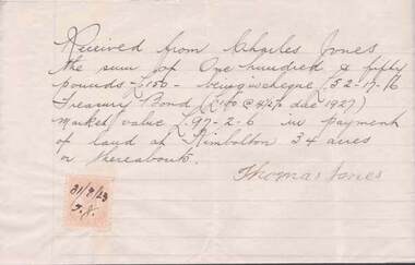
Document - L. PROUT COLLECTION: HANDWRITTEN RECEIPT
... Handwritten receipt signed by Thomas Jones acknowledging he received from Charles Jones the sum of 150 pounds in payment of land at Kimbolton 34 acres or thereabouts. A two pence stamp duty is affixed the the letter and the date 31/08/23 is on the stamp....History House 11 Mackenzie Street Bendigo goldfields DOCUMENT Handwritten receipt signed by Thomas Jones acknowledging he received from Charles Jones the sum of 150 pounds in payment of land at Kimbolton 34 acres or thereabouts. A two pence stamp duty is affixed the the letter and the date 31/08/23 is on the stamp. ...Handwritten receipt signed by Thomas Jones acknowledging he received from Charles Jones the sum of 150 pounds in payment of land at Kimbolton 34 acres or thereabouts. A two pence stamp duty is affixed the the letter and the date 31/08/23 is on the stamp.document -
Bendigo Historical Society Inc.
Map - LYELL : COUNTY OF BENDIGO, 24-10-84
... Lyell, County of Bendigo, Eppalock, Sedgwick, Sutton Grange, Hawkestone, Kimbolton, Coliban River, Myrtle Creek. State School. ...Lyell, County of Bendigo, Eppalock, Sedgwick, Sutton Grange, Hawkestone, Kimbolton, Coliban River, Myrtle Creek. State School. ...Map. Lyell, County of Bendigo, Eppalock, Sedgwick, Sutton Grange, Hawkestone, Kimbolton, Coliban River, Myrtle Creek. State School. Photo-Lithographed at the Department of Lands and Survey, Melbourne by J. Noune, 24-10-84. (number 71 in map cupboard 1)J. Nounemap, bendigo, lyell -
Bendigo Historical Society Inc.
Map - LYELL : COUNTY OF BENDIGO, 24-9-07
... Lyell, County of Bendigo, Sedgwick, Sutton Grange, Hawkestone, Kimbolton, Eppalock, Myrtle Creek, Coliban River. ...Lyell, County of Bendigo, Sedgwick, Sutton Grange, Hawkestone, Kimbolton, Eppalock, Myrtle Creek, Coliban River. ...Map. Lyell, County of Bendigo, Sedgwick, Sutton Grange, Hawkestone, Kimbolton, Eppalock, Myrtle Creek, Coliban River. Photo-Lithographed at the Department of Lands and Survey, Melbourne by T.F. McGauran, 24-9-07, Price 1/-. (number 70 in map cupboard 1)T.F. McGauranmap, bendigo, lyell -
 Bendigo Historical Society Inc.
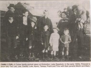
Newspaper - JENNY FOLEY COLLECTION: FAMILY FUN
... Family fun: a Comer family portrait taken at Kimbolton, Lake Eppalock, in the early 1920s pictured is (from left) Ted, Leo, Joe, Cecilia, Luke, Kevin, Teresa, Frank and Tony with their parents Martin and Mary. ...Family fun: a Comer family portrait taken at Kimbolton, Lake Eppalock, in the early 1920s pictured is (from left) Ted, Leo, Joe, Cecilia, Luke, Kevin, Teresa, Frank and Tony with their parents Martin and Mary. ...Martin (1872-1948) and Mary Comer (1883-1972 married in 1907and had the following children; Edward Thomas (1908-1974) Leonard Laurence(1909-1931) Cecilia Mary (1911-1980) Joseph Benedict (1913-1989) Luke Bernard (1914-1931) Kevin Martin (1916-1986) Theresa Agnes (1918-1948) Francis Michael (1919-2000) Anthony John (1922-2011) Leonard and Luke worked with their father at Kimbolten and both drowned on the 28th December 1931, in the Goulbourn River at Arcadia near Murchison. A lad named Madden also drowned at the same time. The family lived in Queen Street, Bendigo.Bendigo Advertiser ''The way we were'' from 2003. Family fun: a Comer family portrait taken at Kimbolton, Lake Eppalock, in the early 1920s pictured is (from left) Ted, Leo, Joe, Cecilia, Luke, Kevin, Teresa, Frank and Tony with their parents Martin and Mary. The clip is in a folder.newspaper, bendigo advertiser, the way we were -
 Bendigo Historical Society Inc.
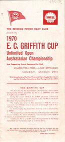
Document - AULSEBROOK COLLECTION: 1970 E.C. GRIFFITH CUP PROGRAMME, 1970
... Griffith Cup Programme -Bendigo Power Boat Club -Unlimited Open Australasian Championship -Kimbolton Pool: Lake Eppalock, March 29th, 1970 -Brief history of cup -Extensive list of events and participants on the day -ads -Large brochure size, folds out, red text,...Griffith Cup Programme -Bendigo Power Boat Club -Unlimited Open Australasian Championship -Kimbolton Pool: Lake Eppalock, March 29th, 1970 -Brief history of cup -Extensive list of events and participants on the day -ads -Large brochure size, folds out, red text, Document AULSEBROOK COLLECTION: 1970 E.C. ...Aulsebrook Collection: 1970 E.C. Griffith Cup Programme -Bendigo Power Boat Club -Unlimited Open Australasian Championship -Kimbolton Pool: Lake Eppalock, March 29th, 1970 -Brief history of cup -Extensive list of events and participants on the day -ads -Large brochure size, folds out, red text,e.g. griffith cup, bendigo power boat club -
 Bendigo Historical Society Inc.
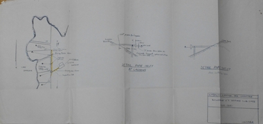
Document - STATE RIVERS AND WATER SUPPLY COMMISSION : KIMBOLTON RECREATIONAL AREA SEWERAGE PLAN
... Plan document titled: Kimbolton Recreational Area Committee. Sewerage of 'C' Section club sites. ...Plan document titled: Kimbolton Recreational Area Committee. Sewerage of 'C' Section club sites. ...State Rivers and Water Supply Commission. Eppalock Project. Plan document titled: Kimbolton Recreational Area Committee. Sewerage of 'C' Section club sites. Rising Mains. Number 101378A is in bottom right corner. Diagrams: Detail pipe inlet at Lagoons, Detail pipe outlet. Plan scale: 1 inch = 6 chns. state infrastructure, water supply, coliban system, eppalock -
 Bendigo Historical Society Inc.
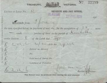
Document - L. PROUT COLLECTION: TREASURY VICTORIA RECEIPT
... Jones the sum specified below in payment of rent for the occupation of 35 acres of land in the parish of Kimbolton under section 8 of the land act 1911. ...Jones the sum specified below in payment of rent for the occupation of 35 acres of land in the parish of Kimbolton under section 8 of the land act 1911. ...Treasury Victoria receipt No. 37759. Licence or Lease no. 12. Revenue and pay office, Bendigo 22 June, 1923. Received from mr. Jones the sum specified below in payment of rent for the occupation of 35 acres of land in the parish of Kimbolton under section 8 of the land act 1911. The sum paid is 2 pounds, 12 shillings and 6 pence.document -
Bendigo Historical Society Inc.
Map - CAMPBELL COLLECTION: BENDIGO AND DISTRICT MAPS
... Block plan key, Bendigo and surrounding districts including : Sandhurst, Nerring, Huntly, Neilborough, Salisbury, Yarrayne, Bridgewater, Yarraberb, Derby, Leichardt, Tarnagulla, Marong, Woodstock, Shelbourne, Lanecoorie, Lockwood, Ravenswood, Mandurang, Sedgwick, Kimbolton, Eppalock, Strathfieldsaye, Axedale, Wellsford, Ellesmere, Bagshot, Goornong, Nolan, Whirrakee, Egerton, Minto. ...Block plan key, Bendigo and surrounding districts including : Sandhurst, Nerring, Huntly, Neilborough, Salisbury, Yarrayne, Bridgewater, Yarraberb, Derby, Leichardt, Tarnagulla, Marong, Woodstock, Shelbourne, Lanecoorie, Lockwood, Ravenswood, Mandurang, Sedgwick, Kimbolton, Eppalock, Strathfieldsaye, Axedale, Wellsford, Ellesmere, Bagshot, Goornong, Nolan, Whirrakee, Egerton, Minto. ...Map. Block plan key, Bendigo and surrounding districts including : Sandhurst, Nerring, Huntly, Neilborough, Salisbury, Yarrayne, Bridgewater, Yarraberb, Derby, Leichardt, Tarnagulla, Marong, Woodstock, Shelbourne, Lanecoorie, Lockwood, Ravenswood, Mandurang, Sedgwick, Kimbolton, Eppalock, Strathfieldsaye, Axedale, Wellsford, Ellesmere, Bagshot, Goornong, Nolan, Whirrakee, Egerton, Minto. (number 347 in map cupboard 1)map, bendigo, allotments -
Bendigo Historical Society Inc.
Map - REDESDALE : COUNTY OF BENDIGO, 24-12-24
... Redesdale, County of Bendigo, County of Dalhousie, Kimbolton, Langwornor, Spring Plains, Glenhope, Emberton, Metcalfe, Hawkestone, County of Talbot, Campaspe River, Back Creek, River Coliban, Lyell. ...Redesdale, County of Bendigo, County of Dalhousie, Kimbolton, Langwornor, Spring Plains, Glenhope, Emberton, Metcalfe, Hawkestone, County of Talbot, Campaspe River, Back Creek, River Coliban, Lyell. ...Map. Redesdale, County of Bendigo, County of Dalhousie, Kimbolton, Langwornor, Spring Plains, Glenhope, Emberton, Metcalfe, Hawkestone, County of Talbot, Campaspe River, Back Creek, River Coliban, Lyell. By authority H.J. Green, Government Printer, Melbourne. Photo-Lithographed at the Department of Lands and Survey, Melbourne by W.J. Butson, 24-12-24, Price 1/-. (number 120 in map cupboard 1)H.J. Green, Government Printer, Melbourne.map, bendigo, redesdale -
Bendigo Historical Society Inc.
Map - REDESDALE : COUNTY OF BENDIGO, 25 -10-77
... Redesdale, County of Bendigo, County of Dalhousie, County Of Talbot, Lyell, Kimbolton, Langwornor, Spring Plains, Glenhope, Emberton, Metcalfe, Hawkestone, River Coliban, Campaspe River, Back Creek. ...Redesdale, County of Bendigo, County of Dalhousie, County Of Talbot, Lyell, Kimbolton, Langwornor, Spring Plains, Glenhope, Emberton, Metcalfe, Hawkestone, River Coliban, Campaspe River, Back Creek. ...Map. Redesdale, County of Bendigo, County of Dalhousie, County Of Talbot, Lyell, Kimbolton, Langwornor, Spring Plains, Glenhope, Emberton, Metcalfe, Hawkestone, River Coliban, Campaspe River, Back Creek. Photo-Lithographed at the Department of Lands and Survey, Melbourne by J. Noune, 25-10-77. Compared with original plans 12-11-78 M. Kemp. J.C.Kelsh, Draughtsman April 1876. Examined by E. Downward, 5-6-77. (number 121 in map cupboard 1)J. Nounemap, bendigo, redesdale -
 Jonadab Masonic Lodge No. 771
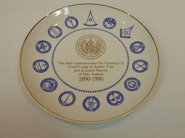
Plate
... kimbolton...This item is significant to Jonadab because it was presented to the Lodge by WBro Donald Viles PGOrganist (New Zealand Constitution) - as a token of affection when he was Master of Jonadab Lodge in 1999-2000. kimbolton nz centenary plate jonadab lodge grand lodge commemorate lodge st andrew no 32 grand master design donald viles Plate - Front "This plate commemorates the Centenary of Grand Lodge of Antient, Free and accepted Masons of New Zealand 1890-1990" Plate - Back "GRAND LODGE OF NEW ZEALAND CENTENARY PLATE" "This plate has been created as one of 5000 only to commemorate the centenary of the Grand Lodge of Antient Free and Accepted Masons of New Zealand" "Conceived by Lodge St Andrew No. 32 the design was authorised by the Most Worshipful the Gand Master" "Manufactured by Crown Lynn Potteries Limited, New Zealand" Blue Outer box - Front Inscription as above Blue Outer box - Back Inscription as above6y Ceramic Plate - white with good rim and fourteen assorted Masonic Symbols in blue paint. ...This plate was created as one of 5000 only to commemorate the Centenary of the Grand Lodge of Antient Free and Accepted Masons of New Zealand 1890-1990. It was conceived by Lodge St Andrew No. 32, and the design was authorised by the Most Worshipful the Gand Master of New Zealand.This item is significant to Jonadab because it was presented to the Lodge by WBro Donald Viles PGOrganist (New Zealand Constitution) - as a token of affection when he was Master of Jonadab Lodge in 1999-2000.Ceramic Plate - white with good rim and fourteen assorted Masonic Symbols in blue paint. Gold printing and gold UGLNZ sealPlate - Front "This plate commemorates the Centenary of Grand Lodge of Antient, Free and accepted Masons of New Zealand 1890-1990" Plate - Back "GRAND LODGE OF NEW ZEALAND CENTENARY PLATE" "This plate has been created as one of 5000 only to commemorate the centenary of the Grand Lodge of Antient Free and Accepted Masons of New Zealand" "Conceived by Lodge St Andrew No. 32 the design was authorised by the Most Worshipful the Gand Master" "Manufactured by Crown Lynn Potteries Limited, New Zealand" Blue Outer box - Front Inscription as above Blue Outer box - Back Inscription as above6y kimbolton, nz, centenary, plate, jonadab lodge, grand lodge, commemorate, lodge st andrew no 32, grand master, design, donald viles -
 Bendigo Historical Society Inc.
Document - CONNELLY, TATCHELL, DUNLOP COLLECTION: LEGAL PAPERS, 1893 - 95
... Summons from Canning J N & Co to Holm Gustave of Kimbolton re payment of debt for chaff & oats. 5 - 1888 - Draft codicil Will of Bockelmann Heinrich Christian. ...Summons from Canning J N & Co to Holm Gustave of Kimbolton re payment of debt for chaff & oats. 5 - 1888 - Draft codicil Will of Bockelmann Heinrich Christian. ...Document. Various legal papers. 1 - 1893 - Letters from Coleman John. Court order Commercial Finance & Prosperity Company Limited v Coleman. 2 - 1893 - Canning Esther Isabelle deceased of Golden Square. Husband Canning Thomas. 3 - Canning - Memos as to distribution of estate. Mentions Canning James Nisbet, Canning J N, and Canning Thos. 4 - 1895 - Canning & Co v Holm. Summons from Canning J N & Co to Holm Gustave of Kimbolton re payment of debt for chaff & oats. 5 - 1888 - Draft codicil Will of Bockelmann Heinrich Christian. Mentions Buckholz Paul Emil Emmanuel. 6 - 1895 - Summons to Seymour George (White Hills) re payment of debt.cottage, miners, connelly, tatchell & dunlop, coleman john, commercial finance & prosperity co. ltd., canning esther isabelle, canning thomas, canning james nisbet, canning j n, canning & co, holm gustave, bockelmann heinrich christian, buckholz paul emil emmanuel, seymour g. -
Bendigo Historical Society Inc.
Map - BENDIGO, 1916
... Bendigo, Gunbower, Gladstone, Talbot, Dalhousie, Rodney, Jarklan, Calivil, Hayanmi, Mitiamo, Wanurp, Pannoobamawm, Bamawm, Millewa, Ballendella, Janiember West, Janiember East, Pompapiel, Talambe, Dingee, Milloo, Pannoomilloo, Rochester West, Yarrayne, Salisbury, Yallook, Tandarra, Kamarooka, Warragamba, Diggorra, Minto, Bridgewater, Yarraberb, Neilborough, Whirrakee, Egerton, Elmore, Nolan, Goornong, Bagshot, Huntly, Derby, Leichardt, Nerring, Tarnagulla, Woodstock, Marong, Sandhurst, Wellsford, Bendigo, Axedale, Strathfieldsaye, Eppalock, Kimbolton, Lyell, Sedgwick, Mandurang, Lockwood, Ravenswood, Shelbourne, Laanecoorie. ...Bendigo, Gunbower, Gladstone, Talbot, Dalhousie, Rodney, Jarklan, Calivil, Hayanmi, Mitiamo, Wanurp, Pannoobamawm, Bamawm, Millewa, Ballendella, Janiember West, Janiember East, Pompapiel, Talambe, Dingee, Milloo, Pannoomilloo, Rochester West, Yarrayne, Salisbury, Yallook, Tandarra, Kamarooka, Warragamba, Diggorra, Minto, Bridgewater, Yarraberb, Neilborough, Whirrakee, Egerton, Elmore, Nolan, Goornong, Bagshot, Huntly, Derby, Leichardt, Nerring, Tarnagulla, Woodstock, Marong, Sandhurst, Wellsford, Bendigo, Axedale, Strathfieldsaye, Eppalock, Kimbolton, Lyell, Sedgwick, Mandurang, Lockwood, Ravenswood, Shelbourne, Laanecoorie. ...Map. Bendigo, Gunbower, Gladstone, Talbot, Dalhousie, Rodney, Jarklan, Calivil, Hayanmi, Mitiamo, Wanurp, Pannoobamawm, Bamawm, Millewa, Ballendella, Janiember West, Janiember East, Pompapiel, Talambe, Dingee, Milloo, Pannoomilloo, Rochester West, Yarrayne, Salisbury, Yallook, Tandarra, Kamarooka, Warragamba, Diggorra, Minto, Bridgewater, Yarraberb, Neilborough, Whirrakee, Egerton, Elmore, Nolan, Goornong, Bagshot, Huntly, Derby, Leichardt, Nerring, Tarnagulla, Woodstock, Marong, Sandhurst, Wellsford, Bendigo, Axedale, Strathfieldsaye, Eppalock, Kimbolton, Lyell, Sedgwick, Mandurang, Lockwood, Ravenswood, Shelbourne, Laanecoorie. Price 3/-. Smaller map of State of Victoria. Lithographed at the Department of Lands and Survey, Melbourne. 1916. Scale : Two miles to one inch. Map was in book form. (number 62 in map cupboard 1)map, bendigo, bendigo -
 Bendigo Historical Society Inc.
Slide - Dunn's Rock Eppalock, 2012
... The low rolling hills of the Kimbolton countryside consist of ancient, hard and fractured Ordovician rock up to 65 million years old, which was originally deposited deep under the sea. ...The low rolling hills of the Kimbolton countryside consist of ancient, hard and fractured Ordovician rock up to 65 million years old, which was originally deposited deep under the sea. ...The low rolling hills of the Kimbolton countryside consist of ancient, hard and fractured Ordovician rock up to 65 million years old, which was originally deposited deep under the sea. Rocks mainly are sandstone, mudstone, black shale and quartz conglomerates. Marine fossils can be found in the area. Around seven million years ago a basalt flow buried the original bedrock along the along the Campaspe River. Ongoing weathering, wind and water movement over the following years has produced younger clay, sand, silt and gravel deposits throughout the area. Patches of White Hills Gravel are also found in the area. Another unique geological feature of this area is the Permian Glacial Pavement rocks north and south of Eppalock and glacial sediments (such as “Dunn’s Rock” and “Kellams Rock”). During the ice age (up to 280 million years ago) large glaciers moving over the countryside, scoured out sediments, pulverized bedrock, polished and cut grooves into bedrock in the direction of ice movement. When the ice melted boulders etc where left behind in areas of entirely different rock types, such as a 100 Tonne granite block known as ‘The Stranger’ near Derrinal. Dunn's Rock (Glaciated Pavement) Eppalock - Photos of the rock and a field group collecting data with Lake Eppalock (Knowsley) in the backgroundhistory, bendigo, dunn's rock eppalock, kimbolton forest, lake eppalock, gately collection