Showing 1194 items matching " land development"
-
 Eltham District Historical Society Inc
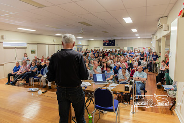
Photograph, Peter Pidgeon, Greg Johnson moves a motion to present to Council the community's view regarding the proposed land sale/development; Eltham Community Town Hall Meeting, Eltham Senior Citizen's Centre, 13 October 2018, 13 Oct 2018
... Greg Johnson moves a motion to present to Council the community's view regarding the proposed land sale/development; Eltham Community Town Hall Meeting, Eltham Senior Citizen's Centre, 13 October 2018...Eltham District Historical Society Inc 728 Main Rd Eltham melbourne Community meeting held at the Eltham Senior Citizen's Centre to discuss Nillumbik Shire Council's advertised proposal to sell the former Shire Office site at 895 Main Road and the Eltham War Memorial complex of buildings at 903-907 Main Road; 13 October 2018 895 main road, 903-907 main road, community meeting, eltham pre-school, eltham shire office, eltham war memorial, eltham war memorial hall, infant welfare centre, nillumbik shire council, senior citizen's centre Born digital image Greg Johnson moves a motion to present to Council the community's view regarding the proposed land sale/development; Eltham Community Town Hall Meeting, Eltham Senior Citizen's Centre, 13 October 2018 Photograph Peter Pidgeon ...Community meeting held at the Eltham Senior Citizen's Centre to discuss Nillumbik Shire Council's advertised proposal to sell the former Shire Office site at 895 Main Road and the Eltham War Memorial complex of buildings at 903-907 Main Road; 13 October 2018Born digital image895 main road, 903-907 main road, community meeting, eltham pre-school, eltham shire office, eltham war memorial, eltham war memorial hall, infant welfare centre, nillumbik shire council, senior citizen's centre -
 Whitehorse Historical Society Inc.
Article, Land Which Overlooks Dandenongs, 1935
... Article on Box Hill to Croydon land development 1935....Article on Box Hill to Croydon land development 1935....Article on Box Hill to Croydon land development 1935. Land Which Overlooks Dandenongs Article Article ...Sale of Land which overlooks Dandenongs.Land which overlooks Dandenongs : Real Estate is reviving between Box Hill and Croydon. Article on Box Hill to Croydon land development 1935.Sale of Land which overlooks Dandenongs.eastern suburbs, melbourne, real estate, transport, local government -
University of Melbourne, Burnley Campus Archives
Document, Land & Water Resources Research & Development Corporation, 1999-2000
... Land & Water Resources Research & Development Corporation...land and water resources development research...Papers relating to the Land & Water Resources Research & Development Corporation. New research programme. ...University of Melbourne, Burnley Campus Archives 500 Yarra Boulevard Richmond melbourne land and water resources development research ruth beilin Papers relating to the Land & Water Resources Research & Development Corporation. ...land and water resources development research, ruth beilin -
 Ringwood and District Historical Society
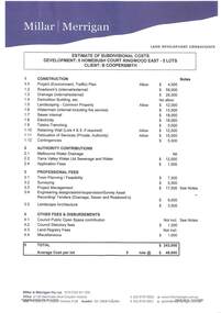
Document, Estimate of Subdivisional Costs - 5 Homebush Court Ringwood East, February 2011. Client: B Coopersmith
... Two A4-pages with blue letterhead - Millar | Merrigan Land Development Consultants, showing itemised estimated costs of construction, authority contributions, prefessional fees and other fees & disbursements. ...Millar & Merrigan Pty Ltd, Land Development Consultants, 2/126 Merrindale Drive, Croydon. ...Millar & Merrigan Pty Ltd, Land Development Consultants, 2/126 Merrindale Drive, Croydon. ...Two A4-pages with blue letterhead - Millar | Merrigan Land Development Consultants, showing itemised estimated costs of construction, authority contributions, prefessional fees and other fees & disbursements. Total $243,000; Average cost per lot - 5 lots @ $48,600. Notes compiled by Brian Mahoney, Feb 2011, Plan 12506 T3 ver1.Millar & Merrigan Pty Ltd, Land Development Consultants, 2/126 Merrindale Drive, Croydon. Telephone (03) 8720 9500, Facsimile (03) 8720 9501. Email [email protected], PO Box 247 Croydon Vic 3136. Ausdoc DX13608 Croydon. Issue no5 - 11/11/2009. -
Whitehorse Historical Society Inc.
Book, Land Settlement, 1987
... land settlement...commercial development...Land settlement and economic development in Nunawading. University of Melbourne History Honours Thesis. 1987...Whitehorse Historical Society Inc. 2-10 Deep Creek Road Mitcham melbourne city of nunawading land settlement commercial development Land settlement and economic development in Nunawading. ...Land settlement and economic development in Nunawading. University of Melbourne History Honours Thesis. 1987Land settlement and economic development in Nunawading. University of Melbourne History Honours Thesis. 1987Land settlement and economic development in Nunawading. University of Melbourne History Honours Thesis. 1987city of nunawading, land settlement, commercial development -
 Glen Eira Historical Society
Document - Thomas, George
... ... Land development...Fulton Business Farmers Farm workers Farms Gardeners Subdivisions Land subdivision Land sales Land prices Land development Land developers Document Thomas, George ...This file contains three items Hand written report on property of George Thomas in Orrong Road, dated 04/06/1985, author unknown Photocopy of four page contract and conditions of sale for lot 262 county of Burke Parish of Prahran. George Thomas property was sold to George William Taylor, dated 20/10/1881 The original photograph of a water colour painting of home and garden of George Thomas, Orrong Road, Caulfield by W. Tibbits 1876thomas eric f, thomas george, beemery park, orrong road, seymour road, allison road, mullaly j, j. fulton, taylor george william, warrein road, north road, stone adelaide, orrong road t. fulton, business, farmers, farm workers, farms, gardeners, subdivisions, land subdivision, land sales, land prices, land development, land developers -
Lakes Entrance Historical Society
Map - Kalimna Allotments
... Land Development...Lakes Entrance Historical Society 4 Marine Parade Lakes Entrance gippsland Land Development land owners Roads and Streets Photocopies of roads and land owners names Lighthouse Reserve Map Kalimna Allotments ...Photocopies of roads and land owners names Lighthouse Reserveland development, land owners, roads and streets -
Save the Dandenongs League Inc.
Archive (item), Save the Dandenongs League Incorporated, Land Constraints to Residential Development in the Upper Yarra Valley and Dandenong Ranges Region - Landscape Living Policy Area
... Land Constraints to Residential Development in the Upper Yarra Valley and Dandenong Ranges Region - Landscape Living Policy Area...Upper Yarra Valley and Dandenong Ranges Authority (UYVDRA) Land Constraints to Residential Development in the Upper Yarra Valley and Dandenong Ranges Region - Landscape Living Policy Area Archive Save the Dandenongs League Incorporated ...upper yarra valley and dandenong ranges authority (uyvdra) -
Save the Dandenongs League Inc.
Archive (item), Save the Dandenongs League Incorporated, Land Constraints to Urban Development in the Upper Yarra Valley and Dandenong Ranges Region - Urban Policy Areas
... Land Constraints to Urban Development in the Upper Yarra Valley and Dandenong Ranges Region - Urban Policy Areas...Upper Yarra Valley and Dandenong Ranges Authority (UYVDRA) Land Constraints to Urban Development in the Upper Yarra Valley and Dandenong Ranges Region - Urban Policy Areas Archive Save the Dandenongs League Incorporated ...upper yarra valley and dandenong ranges authority (uyvdra) -
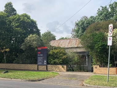
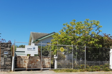
 Eltham District Historical Society Inc
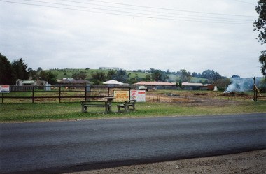
Photograph, Site development, Main Road, Eltham East, 1995, 1995
... ...land development...Eltham District Historical Society Inc 728 Main Rd Eltham melbourne main road eltham east land development trees Two colour photographs of construction of residential development on site of former house and garden Main Road, Eltham East Site development, Main Road, Eltham East, 1995 Photograph ...Two colour photographs of construction of residential development on site of former house and garden Main Road, Eltham Eastmain road, eltham east, land development, trees -
Glen Eira Historical Society
Article - Rosstown Railway
... ... Land Development and Subdivisions...Murray Ross Murray Sugar Beet Mills Mills Elsternwick Land Transport Railways Railway Lines Railway Routes Carnegie Neville Street Carnegie Miller Street Factories Market Gardens Horticulture Peat Soils Land Forms Topography Geology Civic Issues Cone Sugar Industry Elsternwick Plaza Elsternwick Glenhuntly Road Parks and Reserves EE Gunn Reserve Caulfield Racecourse Sportsgrounds Caulfield Carnegie Riddell Parade Clarence Street Aileen Avenue Princes Park Dover Street Marara Road Oakleigh Road Rosanna Street Murrumbeena Crescent North Road Kooyong Road Hawthorn Road Booran Road Koornang Road Poath Road Warragul Road Railway Platforms Railway Buildings Bambra Road Swamps Landforms Landfill Council Landfill Railway Bridges Bridges Railway Underpasses Sporting Clubs Tennis Clubs Bowls Clubs Rosstown Railway Rosanna Street Reserve Maps Railway Maps LIVING IN GLEN EIRA Weickhardt Ian Jowett Des Caulfield South Curraweena Road Oakleigh Caulfield Technical School RETURN TO ROSSTOWN Beet Sugar Industry Crops Land Booms Land Development and Subdivisions Bent Thomas Fink Benjamin Sugar Works Rosstown Hotel Oamdenong Road ROSSTOWN DRY CLEANERS Shops Rosstown Road Rosstown Plate People by Circumstance Migrants Accountants Occupations Professionals THE GRANGE Real Estate Grange Road Financial Agents Judges ROSSTOWN ESTATE Financial Trouble Rabbit Preserving Breweries Political Debates Political Issues Political Electorates Politics Political Science Debt Financial Loans Court Procedures Court Cases Legal Events and Activities MALLESON AND RIGGALL Widowers SEABEACH RAILWAY Economics Economic Deadline Depression 1890s Economic Crash Mortgages Divorce Social Problems Poverty Ross Claude Ross Roderick World War 1914-1918 Wars Military History Servicemen AUSTRALIAN FLYING CORPS Engineers Caulfield Council Swagmen Homelessness Glenhuntly Road Glenhuntly Road Tram Woornack Road Leila Road Wild Cherry Road Melten Avenue Illustrations Steam Trains Trains Horse and Cart Horse-drawn Transport Railway Stations Article Rosstown Railway ...This file contains three items: 1/A review of the ROSSTOWN RAIL TRAIL from LIVING IN GLEN EIRA, vol. 11, 2004, Issue 4, no. 25, date and author unknown. The review explains the purpose of the Rail Trail with a brief narrative of the history behind Rosstown Sugar Mill Railway line. Concluding with information on the location of the Trail and the expected time required to walk the entire track included in the review is a map of the Rail Trail, which marks significant sites along the trail with historic pictures. 2/A newspaper article from THE AGE, dated Tuesday 21/10/1980 and written by Iola Matthews, reporting on the circumstances that led to the publication of the book RETURN TO ROSSTOWN written by Des Jowett and Ian Weickhardt. The article begins with a brief biography of the authors before moving into details of the book’s content, providing a further biography of W. Murray Ross which includes information on his financial ventures – particularly the Rosstown Rail – his marriage and children. The article includes a black and white photograph of Weickhardt and Jowett walking along the route of the railway line, an illustration of the Rosstown sugar works and a map of the area surrounding the site of the mill. 3/Three photocopies of a black and white illustration of the Rosstown sugar works from the east, undated and artist unknown.rosstown rail trail, rosstown, ross william, ross w. murray, ross murray, sugar beet mills, mills, elsternwick, land transport, railways, railway lines, railway routes, carnegie neville street, carnegie miller street, factories, market gardens, horticulture, peat, soils, land forms, topography, geology, civic issues, cone sugar industry, elsternwick plaza, elsternwick, glenhuntly road, parks and reserves, ee gunn reserve, caulfield racecourse, sportsgrounds, caulfield, carnegie, riddell parade, clarence street, aileen avenue, princes park, dover street, marara road, oakleigh road, rosanna street, murrumbeena crescent, north road, kooyong road, hawthorn road, booran road, koornang road, poath road, warragul road, railway platforms, railway buildings, bambra road, swamps, landforms, landfill, council landfill, railway bridges, bridges, railway underpasses, sporting clubs, tennis clubs, bowls clubs, rosstown railway, rosanna street reserve, maps, railway maps, living in glen eira, weickhardt ian, jowett des, caulfield south, curraweena road, oakleigh, caulfield technical school, return to rosstown, beet sugar industry, crops, land booms, land development and subdivisions, bent thomas, fink benjamin, sugar works, rosstown hotel, oamdenong road, rosstown dry cleaners, shops, rosstown road, rosstown plate, people by circumstance, migrants, accountants, occupations, professionals, the grange, real estate, grange road, financial agents, judges, rosstown estate, financial trouble, rabbit preserving, breweries, political debates, political issues, political electorates, politics, political science, debt, financial loans, court procedures, court cases, legal events and activities, malleson and riggall, widowers, seabeach railway, economics, economic deadline, depression 1890s, economic crash, mortgages, divorce, social problems, poverty, ross claude, ross roderick, world war 1914-1918, wars, military history, servicemen, australian flying corps, engineers, caulfield council, swagmen, homelessness, glenhuntly road, glenhuntly road tram, woornack road, leila road, wild cherry road, melten avenue, illustrations, steam trains, trains, horse and cart, horse-drawn transport, railway stations -
Glen Eira Historical Society
Document - LAND SUBDIVISIONS 1880-1938
... ... Land development...A fourth postcard is a map of allotments between Orrong, Kooyong, Seymour and Alison Roads, Caulfield, no date (each 13.5cm x 9cm) 6/Large advertising poster (41cm x 52.5cm) for ‘Carnegie Land Sale’ auction of the Egan Estate (near Carnegie Railway Station) on 12 April, no year given, but appears to be circa1900 7/‘Riddell Estate – Plan of Subdivision – Parish of Prahran’ mounted map, no date, probably c. 1900 (16cm x 21cm) Auctions House auctions Land subdivision Land development Subdivisions Caulfield Land subdivisions East St. ...This file contains various subdivisions’ advertising flyers and cards. 1/Advertising announcement for auction sale of land (15 lots) at Glenhuntly Tram Terminus, to be held on 29/03/1924. Verso is map of the area (21.5cm x 29cm) 2/Advertising announcement for Trustees’ Auction sale of corner shop sites at Caulfield South near Glenhuntly Road and Hawthorn Roads, 15/11/1927 (21cm x 31cm) 3/Advertising pamphlet (A3) for auction of Cantala Estate, East St. Kilda (32 allotments), between Dandenong, Waiora, and Alma Roads, 21/05/1938 (15.5cm x 28.5cm) 4/Seven advertising postcards relating to auctions of land in Caulfield and Elsternwick. Only one (10 December 1881) with a year on it. (Each 13.5cm x 9cm) 5/Four more advertising postcards relating to auctions of land in Caulfield. One is dated 31/11/1880(?); another 09/02/1905. A third has no date. A fourth postcard is a map of allotments between Orrong, Kooyong, Seymour and Alison Roads, Caulfield, no date (each 13.5cm x 9cm) 6/Large advertising poster (41cm x 52.5cm) for ‘Carnegie Land Sale’ auction of the Egan Estate (near Carnegie Railway Station) on 12 April, no year given, but appears to be circa1900 7/‘Riddell Estate – Plan of Subdivision – Parish of Prahran’ mounted map, no date, probably c. 1900 (16cm x 21cm)auctions, house auctions, land subdivision, land development, subdivisions, caulfield, land subdivisions, east st. kilda, glenhuntly, carnegie, map, ‘new glenhuntly tram terminus estate’, ‘cantala estate’, ‘strathnaver estate’, ‘range estate’, ‘egan estate’, ‘riddell estate’ -
 Bendigo Historical Society Inc.
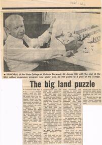
Document - LA TROBE UNIVERSITY BENDIGO COLLECTION: THE BIG LAND PUZZLE10-ACRE MIX UP
... ... land development...James Mac Hill land development State College of Victoria Burwood Campus tertiary education Mr. ...A newspaper article titled 'The Big Land Puzzle: 10-acre mix up'. This relates to a difference of opinion over what a 10 acre site was bought for. The Principal of the State College of Victoria, Burwood Mr. James Mac Hill, said it wasn't bought for a college to train teachers for handicapped children as was reported by The Minister for Education Mr. Lindsay Thompson. The Principal said the land was being acquired by the State College of Victoria, campus. The article includes a photo of Mr. Hill. Gazette, 1974.bendigo, education, state college of victoria burwood, la trobe university bendigo collection, collection, bendigo teachers' college, mr. james mac hill, land development, state college of victoria burwood campus, tertiary education, mr. lindsay thompson, minister of education -
 Greensborough Historical Society
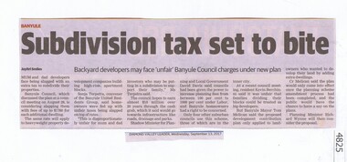
Newspaper Clipping, Subdivision tax set to bite, 13/09/2017
... ...land development...Greensborough Historical Society 34A Glenauburn Road Lower Plenty Lower Plenty melbourne Mum and dad developers face being slugged with an extra tax to subdivide their properties. tax subdivision plans land development banyule city council News article 1 page, black text. ...Mum and dad developers face being slugged with an extra tax to subdivide their properties.News article 1 page, black text.tax, subdivision plans, land development, banyule city council -
 Greensborough Historical Society
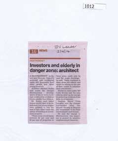
Newspaper Clipping, Investors and elderly in danger zone: architect, 02/04/2014
... ...land development...Greensborough Historical Society 34A Glenauburn Road Lower Plenty Lower Plenty melbourne Changes to residential development zones in Montmorency would effect local homeowners, according to architect Michael Scalzo. montmorency land development News clipping, black text. Investors and elderly in danger zone: architect Newspaper Clipping Diamond Valley Leader ...Changes to residential development zones in Montmorency would effect local homeowners, according to architect Michael Scalzo.News clipping, black text.montmorency, land development -
 Greensborough Historical Society
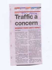
Newspaper Clipping, Traffic a concern, 19/03/2014
... ...land development...Greensborough Historical Society 34A Glenauburn Road Lower Plenty Lower Plenty melbourne Concerns are raised over the 38-apartment development at 4 Poulter Avenue Greensborough. poulter avenue greensborough michael karagiannis land development News clipping, black text. Traffic a concern Newspaper Clipping ...Concerns are raised over the 38-apartment development at 4 Poulter Avenue Greensborough.News clipping, black text.poulter avenue greensborough, michael karagiannis, land development -
 Greensborough Historical Society
Photograph - Photograph - Digital Image, Marilyn Smith, Redevelopment of 184 Watsonia Road 2021, 2021
... ...land development...Greensborough Historical Society 34A Glenauburn Road Lower Plenty Lower Plenty melbourne Digital images of houses at 184 Watsonia Road Watsonia, before and after redevelopment 2021 Part of a collection of miscellaneous historical images with a connection to the local area. watsonia road watsonia land development Collection of digital colour photographs Redevelopment of 184 Watsonia Road 2021 Photograph Photograph - Digital Image Marilyn Smith Sandy Anton Janice Smith ...Digital images of houses at 184 Watsonia Road Watsonia, before and after redevelopment 2021Part of a collection of miscellaneous historical images with a connection to the local area.Collection of digital colour photographswatsonia road watsonia, land development -
 Greensborough Historical Society
Photograph - Photograph - Digital Image, Marilyn Smith, Redevelopment of 17 Doris Street Greensborough, 2020-2022
... ...land development...Greensborough Historical Society 34A Glenauburn Road Lower Plenty Lower Plenty melbourne Digital images of houses at 17 Doris Street Greensborough, before and after redevelopment 2020-2022 Part of a collection of miscellaneous historical images with a connection to the local area. doris street greensborough land development Digital colour photographs Redevelopment of 17 Doris Street Greensborough Photograph Photograph - Digital Image Marilyn Smith ...Digital images of houses at 17 Doris Street Greensborough, before and after redevelopment 2020-2022Part of a collection of miscellaneous historical images with a connection to the local area.Digital colour photographsdoris street greensborough, land development -
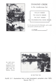 Eltham District Historical Society Inc
Work on paper (Sub-Item) - Photograph, Illustrations from a land developer's pamphlet promoting Diamond Creek, circa 1925
... ...land development...Eltham District Historical Society Inc 728 Main Rd Eltham melbourne Photos illustrating the Diamond Creek with a bridge over it and two people sitting by the creek, one is fishing with text describing the kind of person who may like to come to the township. diamond creek advertising promotion land development real estate Image printed on A4 page from 04997 Diamond Creek Basin Study, 1980 Illustrations from a land developer's pamphlet promoting Diamond Creek, circa 1925 Work on paper Photograph ...Photos illustrating the Diamond Creek with a bridge over it and two people sitting by the creek, one is fishing with text describing the kind of person who may like to come to the township. diamond creek, advertising, promotion, land development, real estate -
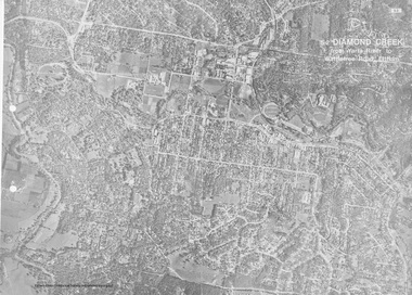 Eltham District Historical Society Inc
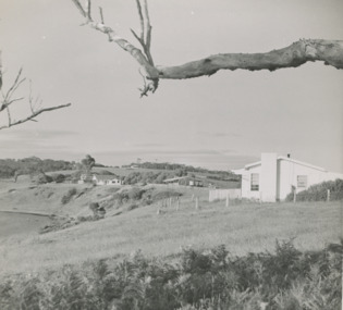
Work on paper (Sub-Item) - Aerial Photograph, Diamond Creek from Yarra River to Wattletree Road, Eltham
... land development...Eltham District Historical Society Inc 728 Main Rd Eltham melbourne Black and white aerial photograph witrh key features around the central place of Eltham township marked inluding Yarra River, Main Road, Bridge Street and Ryans Road, Eltham North land development real estate aerial view Eltham Eltham North Image printed on foldout A3 page from 04997 Diamond Creek Basin Study, 1980 Diamond Creek from Yarra River to Wattletree Road, Eltham Work on paper Aerial Photograph ...Black and white aerial photograph witrh key features around the central place of Eltham township marked inluding Yarra River, Main Road, Bridge Street and Ryans Road, Eltham North land development, real estate, aerial view, eltham, eltham north -
 Lakes Entrance Historical Society
Photograph, Holding M, Whiters Camp Park, c1994
... ...Land Development...Resort Tourism Land Development Colour copy photograph showing the cleared land which was previously part of Whiters Camp Park, in preparation for the building of a complex of attractive brick units in Roadknight Street. ...Colour copy photograph showing the cleared land which was previously part of Whiters Camp Park, in preparation for the building of a complex of attractive brick units in Roadknight Street. Estate agent's advertising signs on fence. Lakes Entrance Victoriaresort, tourism, land development -
Clunes Museum
Newspaper - NEWSPAPER CUTTING, AUSTRALIA POST PUBLICATIONS, 1986
... ...CLUNES LAND DEVELOPMENT...NEWSPAPER CUTTING REPORTING THE CONFUSION AT CLUNES BETWEEN LAND DEVELOPER AND TALBOT CLUNES SHIRE COUNCIL. 11/9/1986 RE DEVELOPMENT McLENNANS ROAD. ...Clunes Museum 36 Fraser Street enter building through Collins Place Clunes goldfields LOCAL HISTORY DOCUMENT NEWSPAPER CUTTING CLUNES LAND DEVELOPMENT NEWSPAPER CUTTING REPORTING THE CONFUSION AT CLUNES BETWEEN LAND DEVELOPER AND TALBOT CLUNES SHIRE COUNCIL. 11/9/1986 RE DEVELOPMENT McLENNANS ROAD. ...NEWSPAPER CUTTING REPORTING THE CONFUSION AT CLUNES BETWEEN LAND DEVELOPER AND TALBOT CLUNES SHIRE COUNCIL. 11/9/1986 RE DEVELOPMENT McLENNANS ROAD. REPORTER BOB O'BRIEN - PHOTOGRAPHER PAUL O'BRIEN.local history, document, newspaper cutting, clunes land development -
Box Hill Historical Society
Book, B. V. Fullard & Associates Pty. Ltd, Valuation and Report, Parklands, Koonung Creek Valley, 9/09/1994
... ...Land Development...Box Hill Historical Society Box Hill Heritage Centre Suite 7 Town Hall Hub Box Hill melbourne Land prices Land values Construction Maps Koonung Creek valley Eastern Freeway Land Development Report and valuation of Park Lands along the Koonung Creek Valley. ...Report and valuation of Park Lands along the Koonung Creek Valley. Description of land and compensation valuation for construction of the proposed Eastern Freeway.land prices, land values, construction, maps, koonung creek valley, eastern freeway, land development -
 Lakes Entrance Historical Society
Photograph - " Corumbene" Carpenter Street Lakes Entrance, 1/11/1952 12:00:00 AM
... Land Development...Land adjacent to North Arm later subdivided for residential development Lakes . ...Land adjacent to North Arm later subdivided for residential development Lakes Entrance Victoria. ...House moved from Coates Rd to O'Neils Rd Lakes Entrance 1989 Land Development Houses Black and white photograph of the property Corumbene at back of photograph behind tall tree c1952. ...White house in foreground Basil and Joan Mitchelson's, white house closer to Corumbene home of Jack and Aileen Daniel. Land adjacent to North Arm later subdivided for residential development Lakes . Corumbene later subdivided fronted by Carpenter Street today. House moved from Coates Rd to O'Neils Rd Lakes Entrance 1989 Black and white photograph of the property Corumbene at back of photograph behind tall tree c1952. White house in foreground Basil and Joan Mitchelson's, white house closer to Corumbene home of Jack and Aileen Daniel. Land adjacent to North Arm later subdivided for residential development Lakes Entrance Victoria. Also another black and white photographs showing property Corumbene later subdivided fronted by Carpenter Street today. Plus 2 coloured photos of a house being moved from Coates Rd to O'Neils Rd Lakes Entrance 1989land development, houses -
 Lakes Entrance Historical Society
Photograph - Riviera Beach Resort, Lakes Post Newspaper, 1/09/1994 12:00:00 AM
... ...Land Development...Lakes Entrance Historical Society 4 Marine Parade Lakes Entrance gippsland Holiday Concepts Riviera Beach Resort Rowe Street comprising seven self contained villas on timeshare concept Lakes Entrance Victoria Tourism Accommodation Land Development Black and white of Holiday Concepts Riviera Beach Resort Rowe Street comprising seven self contained villas on timeshare concept Lakes Entrance Victoria Riviera Beach Resort Photograph Riviera Beach Resort Lakes Post Newspaper ...Holiday Concepts Riviera Beach Resort Rowe Street comprising seven self contained villas on timeshare concept Lakes Entrance VictoriaBlack and white of Holiday Concepts Riviera Beach Resort Rowe Street comprising seven self contained villas on timeshare concept Lakes Entrance Victoriatourism, accommodation, land development -
Lakes Entrance Historical Society
Map - Kalimna Heights, Jemmys Point Lakes Entrance, Dalgetty & Co, 17/1/1953
... Land Development...Lakes Entrance Historical Society 4 Marine Parade Lakes Entrance gippsland Land Development Auction Businesses Map of seaside blocks overlooking North Arm and Lakes Entrance to be auctioned Saturday January 17 1953 at the Mechanics Hall. 3 pages Map Kalimna Heights, Jemmys Point Lakes Entrance Dalgetty & Co ...Map of seaside blocks overlooking North Arm and Lakes Entrance to be auctioned Saturday January 17 1953 at the Mechanics Hall. 3 pagesland development, auction, businesses -
Lakes Entrance Historical Society
Map - Subdivision of Allotments 84B and 85B Parish of Colquhoun County of Tambo
... Land Development...Lakes Entrance Historical Society 4 Marine Parade Lakes Entrance gippsland Land Development Roads and Streets Waterways Map shows subdivision from Albatross Road showing Creighton Street and North Arm Map Subdivision of Allotments 84B and 85B Parish of Colquhoun County of Tambo ...Map shows subdivision from Albatross Road showing Creighton Street and North Armland development, roads and streets, waterways -
Lakes Entrance Historical Society
Map - Allotments Township of Cunninghame, Dept of Lands and Survey
... Land Development...Lakes Entrance Historical Society 4 Marine Parade Lakes Entrance gippsland Map is pasted together with properties Lake Tyers Auction Land Development Townships Islands Colquhoun Counties of Tambo and Tanjil Map shows selections of allotments in the towns of Cunninghame and Kalimna including Rigby Island and Fraser Island Map Allotments Township of Cunninghame Dept of Lands and Survey ...Map is pasted together with properties Lake Tyers AuctionMap shows selections of allotments in the towns of Cunninghame and Kalimna including Rigby Island and Fraser IslandColquhoun Counties of Tambo and Tanjilland development, townships, islands -
Lakes Entrance Historical Society
Map - House Allotments Lake Tyers
... Land Development...Lakes Entrance Historical Society 4 Marine Parade Lakes Entrance gippsland Tambo Shire Historical Society Cat No. 23 Land Development Auction Advertising Big Auction - on the property Lake Tyers. ...Tambo Shire Historical Society Cat No. 23Map showing house blocks for auction at Lake Tyers. Pasted together with properties Lakes Entrance Colquhoun Counties of Tambo and Tanjil Big Auction - on the property Lake Tyers. land development, auction, advertising -
 Lakes Entrance Historical Society
Album, Vera Bennett, Johnsonville School becomes Lakes Entrance Regional Historical Society Lakes Entrance Victoria, 2004 c
... ...Land Development...Lakes Entrance Historical Society 4 Marine Parade Lakes Entrance gippsland Historic Sites Schools Land Development A small album with photographs showing the transformation of Johnsonville School to become Lakes Entrance Regional Historical Society Lakes Entrance Victoria. ...A small album with photographs showing the transformation of Johnsonville School to become Lakes Entrance Regional Historical Society Lakes Entrance Victoria. Please visit History Centre to view full albumhistoric sites, schools, land development