Showing 4 items matching " lightning hill anticline"
-
 Bendigo Historical Society Inc.
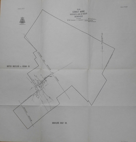
Map - COMET MINE - PLAN OF COMET MINE
... ... Lightning Hill Anticline...Map shows depths, Lightning Hill Anticline, Hustler's Anticline and approximate Lease Boundary. ...Map shows depths, Lightning Hill Anticline, Hustler's Anticline and approximate Lease Boundary. ...Plan of the Comet Mine on the Hustler's Line of Reefs Bulletin No 33, Plate No XXIII. Map shows depths, Lightning Hill Anticline, Hustler's Anticline and approximate Lease Boundary. Signed by H. S. Whitelaw, Underground Survey Office Bendigo, September 1913. United Hustler's & Redan Co and Hustler's Reef Co also named on map. Geological Survey of Victoriamining, hustler's line of reefs, comet line plan belletin no 33 plate no xxiii, lightning hill anticline, hustler's anticline, united hustler's & redan co, hustler's reef co, h s whitelaw -
 Bendigo Historical Society Inc.
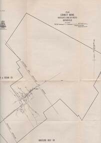
Map - STRUGNELL COLLECTION: HUSTLER'S LINE OF REEFS, BENDIGO
... XX111 (23).Lightning Hill Anticline at Surface, United Hustler's & Redan Co., Hustler's Reef Co. ...XX111 (23).Lightning Hill Anticline at Surface, United Hustler's & Redan Co., Hustler's Reef Co. ...Map, Hustler's Line of Reefs, Comet Mine, Plan, Plate No. XX111 (23).Lightning Hill Anticline at Surface, United Hustler's & Redan Co., Hustler's Reef Co. Bulletin No 33 Signed H.A. Whitelaw Underground survey Office Bendigo September 1913Underground Survey Office, Bendigo.bendigo mines, hustler's line of reef, comet mine -
 Bendigo Historical Society Inc.
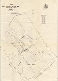
Map - GREAT EXTENDED HUSTLER'S MINE - PLAN OF THE GREAT EXTENDED HUSTLER'S MINE
... Mine was located in the block bounded by Langston and Anderson Streets and was between the Hustler's Anticline at Surface and the Lightning Hill Anticline at Surface. Latham & Watson's Shaft is also mentioned. ...Mine was located in the block bounded by Langston and Anderson Streets and was between the Hustler's Anticline at Surface and the Lightning Hill Anticline at Surface. Latham & Watson's Shaft is also mentioned. ...Plan of the Great Extended Hustler's Mine on the Hustler's Line of Reefs, Bendigo. Bulletin No 33, Plate No X. Lease No 7382. Plan has map of streets. Mine was located in the block bounded by Langston and Anderson Streets and was between the Hustler's Anticline at Surface and the Lightning Hill Anticline at Surface. Latham & Watson's Shaft is also mentioned. Levels are numbered and a table shows the Levels and their Depths. Geological Survey of Victoria. Signed by H A Whitelaw, Underground Survey Office, Bendigo, September 1913. This item has not been scanned or photographed.mining, parish map, great extended hustler's mine, hustler's line of reefs, mining lease no 7382, geological survey of victoria, underground survey office bendigo, h a whitelaw, latham & watson's shaft -
 Bendigo Historical Society Inc.
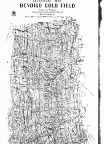
Map - LONG GULLY HISTORY GROUP COLLECTION: GEOLOGICAL MAP - BENDIGO GOLD FIELD
... History House 11 Mackenzie Street Bendigo goldfields BENDIGO History long gully history group The Long Gully History Group - Geological map - Bendigo Gold Field Mines Department H Herman Lightning Hill Line Hustlers Line Derby Line Paddy's Gully Line Garden Gully Line Deborah Line Sheepshead Line New Chum Line Nell Gwynne Line British and Foreign Line Napoleon Line Carshalton Line Thistle Line Christmas Line Lancashire Line Copy of a Geological Map of the Bendigo Gold Field. Map shows Lines of Reef, Anticlines ...Copy of a Geological Map of the Bendigo Gold Field. Map shows Lines of Reef, Anticlines, Synclines, Shafts, Alluvial Contours Gullies and some street names. Copy is hard to read. There are two pages.bendigo, history, long gully history group, the long gully history group - geological map - bendigo gold field, mines department, h herman, lightning hill line, hustlers line, derby line, paddy's gully line, garden gully line, deborah line, sheepshead line, new chum line, nell gwynne line, british and foreign line, napoleon line, carshalton line, thistle line, christmas line, lancashire line