Showing 7 items matching " loch avenue"
-
 Glen Eira Historical Society
Article - Carrington Grove, 8, St Kilda East
... ... Loch Avenue...The report provides a list of occupants and briefly mentions Charles Carrington and Lord Loch after whom Loch Avenue and Carrington Grove was named. The file also includes one page of accompanying handwritten working notes. ...The report provides a list of occupants and briefly mentions Charles Carrington and Lord Loch after whom Loch Avenue and Carrington Grove was named. The file also includes one page of accompanying handwritten working notes. ...A one page typed report dated 05/08/1989, by H Bullock and R Landells, containing a brief history of the house at 8 Carrington Grove from 1914 to 1989. The report provides a list of occupants and briefly mentions Charles Carrington and Lord Loch after whom Loch Avenue and Carrington Grove was named. The file also includes one page of accompanying handwritten working notes. The file also includes a photocopy of an article from a book, title and publication details unknown, containing a biography of Charles Robert Carrington. A one page research note by Chloe Stapleton, dated 08/05/2012, identifies the source of the article.carrington grove, st kilda east, loch avenue, heads of state, governors, officials, depression 1890s, economic depression, world war 1914-1918, carrington charles robert, harrop thomas s, harrop r, koesis l, mitchell n i, bullock h, landells r -
 The Beechworth Burke Museum
Photograph
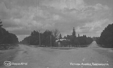
... ...victoria avenue...loch...Taken in Beechworth, this photograph depicts the intersection between Victorian Avenue and Loch Street. ...The Beechworth Burke Museum Loch Street Beechworth high-country Taken in Beechworth, this photograph depicts the intersection between Victorian Avenue and Loch Street. beechworth victoria avenue loch street burke museum photograph postcard intersection Obverse: F & V SERIES NO 15 VICTORIA AVENUE, BEECHWORTH (hand printed) Reverse: A03086 97.21.99 POST CARD R Pigram Cootamundra Black and white photograph printed on a rectangular postcard Photograph Photograph ...Taken in Beechworth, this photograph depicts the intersection between Victorian Avenue and Loch Street. Black and white photograph printed on a rectangular postcardObverse: F & V SERIES NO 15 VICTORIA AVENUE, BEECHWORTH (hand printed) Reverse: A03086 97.21.99 POST CARD R Pigram Cootamundra beechworth, victoria avenue, loch street, burke museum, photograph, postcard, intersection -
 The Beechworth Burke Museum
Photograph, c1916
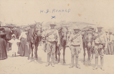
... Loch Street Beechworth high-country Taken during World War 1, this photo is taken of three soldiers and their horses, featuring families in the background. One of the men featured is H. J. Ronald. This photograph is historically significant as it provides insight into the uniforms and clothing worn during the early 20th century and World War 1 period. Military Album Burke Museum Beechworth Beechworth Museum World War One WWI Horses H.J.Ronald Soldiers Soldiers and Horses Observe: H. J. RONALD Reverse: H. J. Ronald / Donated by George Ronald / 49 Jellico Avenue ...Taken during World War 1, this photo is taken of three soldiers and their horses, featuring families in the background. One of the men featured is H. J. Ronald.This photograph is historically significant as it provides insight into the uniforms and clothing worn during the early 20th century and World War 1 period. Black and white rectangular photograph printed on photograph paper and mounted on a beige card.Observe: H. J. RONALD Reverse: H. J. Ronald / Donated by George Ronald / 49 Jellico Avenue / 5898 (crossed out) / Tallangattamilitary album, burke museum, beechworth, beechworth museum, world war one, wwi, horses, h.j.ronald, soldiers, soldiers and horses -
 The Beechworth Burke Museum
Postcard, R & B Hall, c.1930
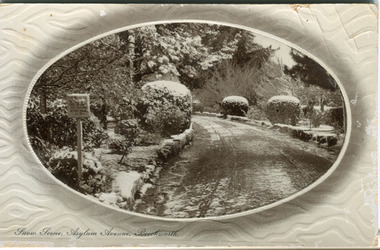
... Loch Street Beechworth high-country This postcard was published by R. & B. Hall in Beechworth and printed in Saxony, circa 1930. Saxony is a landlocked state of Germany which borders the states of Brandenburg, Saxony-Anhalt, Thuringia, Bavaria and the countries of Poland and the Czech Republic. This particular postcard is embossed with a pattern which surrounds the middle image in the center of the card. This image depicts Asylum Avenue ...This postcard was published by R. & B. Hall in Beechworth and printed in Saxony, circa 1930. Saxony is a landlocked state of Germany which borders the states of Brandenburg, Saxony-Anhalt, Thuringia, Bavaria and the countries of Poland and the Czech Republic. This particular postcard is embossed with a pattern which surrounds the middle image in the center of the card. This image depicts Asylum Avenue which leads to the Mayday Hills Asylum in Beechworth, Victoria. What makes this scene particularly interesting is the appearance of snow which is rare in Beechworth. The road depicted on the postcard has track marks made by a car with thin wheels. Beechworth's Mayday Hills was chosen as the site of Victoria's newest asylum, at the time, due to the landscape and altitude. The hilltop atmosphere and the native fauna, it was argued, would assist in the cure of the patients kept at the hospital (Wood 1985, 122). The positioning of the hospital had a beneficial effect on the rural town. A pamphlet published by James Ingram and Son (1849) reveal that famous landmarks in Beechworth which included the Post Office, Gaol, Courthouse and Asylum "demonstrate the appreciation of Beechworth by the Government not only as as important district center, but also as a site unrivaled as a sanitarium". There were other locations in contention at the time, but ultimately Beechworth was chosen (Craig 2000, 33). Prior to the creation of the Asylum in Beechworth, those charged with having mental illnesses or, as it was termed, "insanity" were unable to be properly cared for in the Gaol (which is where they were often sent). John Buckley Castieau wrote, in 1861 for the Ovens and Murray Advertiser, that the Gaol was unable to properly care for those classified then as "insane" but that they would endeavor to treat them above the other inmates (which he notes is not always the case in other establishments). Castieau wrote this in favour of supporting the building of the Mayday Hills Hospital in Beechworth. It was stated that at the time the Mayday Hills Hospital was built, there were 83 prisoners kept in the Gaol who were to be rehoused to the Hospital on the grounds of "insanity". The classification as someone as "insane", in this period of time is a reflection on the inability to cure and understand illnesses of the mind during the mid to late 1800s. Beechworth's Mayday Hills was chosen as the site of Victoria's newest asylum, at the time, due to the landscape and altitude. Opening on the 24th of October 1867, the Mayday Hills Hospital was originally named the "Ovens Lunatic Asylum", a title which is very much a product of its time. Whilst controversial, changes to the name is part of the history of the Hospital and can provide much insight into the understanding of mental illness throughout history and the use/disuse of this term provides information into the reception/changing opinions of mental illness in society. The Hospital would later become known as the "Mayday Hills Asylum" and/or "Mayday Hills Hospital" with the latter being the most commonly used title. An article in the Ovens and Murray Advertiser notes that on the 7th of March 1865, the foundation stone of the Hospital was laid (it would officially open in 1867) and that it was such a moment of accomplishment and joy for Beechworth that a letter to the editor even suggested that there should be a holiday dedicated to the day the foundation stone as laid. This reveals an extent to which the townspeople of early Beechworth valued the construction of the Hospital in their town. It provided the town with a sense of prestige and honour.At first glance, the remains of the Mayday Hills Hospital in Beechworth, Victoria, inspire tragedy, trauma and beauty. The buildings themselves, with their Italianate style Renaissance architecture designed by J.J. Clark (Craig 2000, 49 & Smith 2016, 203) reflect a bygone period of European and Australian history. The gardens provide a sense of tranquility and beauty. The experience of those within these walls remains a valuable area of study to provide a more complete understanding. This particular hospital is considered the fourth of its like and one of three identified as the largest of their kind. The Mayday Hills Hospital is a sister to the Kew and Ararat Asylums in Melbourne which are both located in relative proximity. Understanding the role of the Mayday Hills Hospital in Beechworth history is integral to understanding the development of the goldfields town, but also for providing important information as to the history of caring for, and the reception of, mental illnesses in Australian and wider European history. Mayday Hills provides a case study which can be researched through oral history, an analysis of the grounds/buildings and through images like this postcard which portray the structure in a highly deliberate manner. Images like this depict the strong façade of the Hospital and provide a glimpse into the tranquility of the gardens. This has been done deliberately to provide a sense of comfort and healing about the building to those looking from the outside. Further research into the importance of the Hospital in Beechworth and it's connection to the town will be supported through images like these kept in the Mayday Hills photo album in the collection of the Burke Museum.Pale coloured rectangular postcard printed on matte embossed card.Obverse: Snow Scene; Asylum Avenue, Beechworth. / Reverse: POST CARD / ADDRESS ONLY / Published by R. & B. Hall, Beechworth. / Printed in Saxony. / 3447 [crossed out] / 1997.2492 / AFFIX STAMP /asylum, asylum avenue, beechworth, snow north-east vic, victoria, snow scene, mayday hills, mayday hills hospital, mental hospital, colonial attitudes, mental health, history, town development, postcard -
Surrey Hills Historical Society Collection
Folder of real estate advertisements, Folders of real estate advertisements (Streets beginning with L), Various
... loch street...lorne parade...louise avenue...Surrey Hills Historical Society Collection 190A Canterbury Road Canterbury melbourne laing street lambourne street langford street leopold street leura street lightfoot street lille street loch street lorne parade louise avenue A4 folders with individual pockets for each property in streets beginning with L located in Surrey Hills and Mont Albert. ...A4 folders with individual pockets for each property in streets beginning with L located in Surrey Hills and Mont Albert. Folders are ordered by street name and then chronologically by property number. Each property has its own pocket. This may include multiple real estate advertisements collected from sales over time. It may also include copies of any research undertaken by Alan Holt and / or members of the SHNCHC team. These are augmented by cards in the Alan Holt index file and by his property registers of Surrey Hills and Mont Albert.laing street, lambourne street, langford street, leopold street, leura street, lightfoot street, lille street, loch street, lorne parade, louise avenue -
 Kew Historical Society Inc
Plan - Subdivision Plan, Goldthorns Hill Estate, 1925
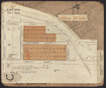
... Goldthorns Avenue -- Kew East (Vic.)...Lady Loch...Goldthorns Avenue -- Kew East (Vic.) Lady Loch Drive -- Kew East (Vic.) ...Pru Sanderson, in her groundbreaking ‘City of Kew Urban Conservation Study : Volume 2 - Development History’ (1988), summarised the periods of urban development and subdivisions of land in Kew. The periods that she identified included 1845-1880, 1880-1893, 1893-1921, 1921-1933, 1933-1943, and Post-War Development. These periods were selected as they represented periods of rapid growth or decline in urban development. An obvious starting point for Sanderson’s groupings involved population growth and the associated economic cycles. These cycles also highlighted urban expansion onto land that was predominantly rural, although in other cases it represented the decline and breakup of large estates. A number of the plans in the Kew Historical Society’s collection can also be found in other collections, such as those of the State Library of Victoria and the Boroondara Library Service. A number are however unique to the collection.The Kew Historical Society collection includes almost 100 subdivision plans pertaining to suburbs of the City of Melbourne. Most of these are of Kew, Kew East or Studley Park, although a smaller number are plans of Camberwell, Deepdene, Balwyn and Hawthorn. It is believed that the majority of the plans were gifted to the Society by persons connected with the real estate firm - J. R. Mathers and McMillan, 136 Cotham Road, Kew. The Plans in the collection are rarely in pristine form, being working plans on which the agent would write notes and record lots sold and the prices of these. The subdivision plans are historically significant examples of the growth of urban Melbourne from the beginning of the 20th Century up until the 1980s. A number of the plans are double-sided and often include a photograph on the reverse. The Goldthorns Hill Estate subdivision was first put up for auction in 1925. The subdivision took its name from the mansion ‘Goldthorns’, shown on the plan between Normanby Road and Lady Loch’s Drive. Contemporary advertisements describe forty-three home sites being fro sale, yet only forty-one appear on this plan. Buyers were lured by the prospect of the proposed extension of the Burke Road tram to High Street. Discerning buyers were advised that only one house could be built per allotment, and that houses needed to be constructed of brick, stone or concrete and have a slate or tiled roof.goldthorns avenue -- kew east (vic.), lady loch drive -- kew east (vic.), argyle road -- kew east (vic.), lady brassey drive -- kew east (vic.), campbell street -- kew east (vic.), goldthorns -- kew (vic.), subdivisions -- kew east (viv.), goldthorns hill estate -
 Kew Historical Society Inc
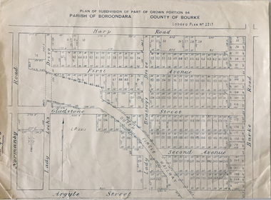
Plan - Subdivision Plan, Plan of Subdivision of Part of Crown Portion 84 / Parish of Boroondara / County of Bourke / Lodged Plan No. 2217, Twentieth Century
... Subdivision plans -- Kew (Vic) Harp Road Burke Road Normanby Road Lady Loch's Drive Gladstone Street Second Avenue First Avenue Undated Plan of Subdivision of Crown Portion 84 in what is now Kew. ...Pru Sanderson, in her groundbreaking ‘City of Kew Urban Conservation Study : Volume 2 - Development History’ (1988), summarised the periods of urban development and subdivisions of land in Kew. The periods that she identified included 1845-1880, 1880-1893, 1893-1921, 1921-1933, 1933-1943, and Post-War Development. These periods were selected as they represented periods of rapid growth or decline in urban development. An obvious starting point for Sanderson’s groupings involved population growth and the associated economic cycles. These cycles also highlighted urban expansion onto land that was predominantly rural, although in other cases it represented the decline and breakup of large estates. A number of the plans in the Kew Historical Society’s collection can also be found in other collections, such as those of the State Library of Victoria and the Boroondara Library Service. A number are however unique to the collection.The Kew Historical Society collection includes almost 100 subdivision plans pertaining to suburbs of the City of Melbourne. Most of these are of Kew, Kew East or Studley Park, although a smaller number are plans of Camberwell, Deepdene, Balwyn and Hawthorn. It is believed that the majority of the plans were gifted to the Society by persons connected with the real estate firm - J. R. Mathers and McMillan, 136 Cotham Road, Kew. The Plans in the collection are rarely in pristine form, being working plans on which the agent would write notes and record lots sold and the prices of these. The subdivision plans are historically significant examples of the growth of urban Melbourne from the beginning of the 20th Century up until the 1980s. A number of the plans are double-sided and often include a photograph on the reverse. A number of the latter are by noted photographers such as J.E. Barnes.Undated Plan of Subdivision of Crown Portion 84 in what is now Kew. The area shown is bordered by Burke Road, Harp Road, Arglye Road and Normanby Road.subdivision plans -- kew (vic), harp road, burke road, normanby road, lady loch's drive, gladstone street, second avenue, first avenue