Showing 607 items matching " mining areas"
-
 Bendigo Historical Society Inc.
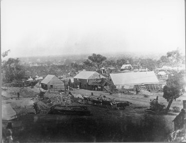
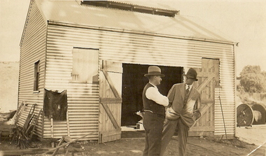
Newspaper - LONG GULLY HISTORY GROUP COLLECTION: LANDSCAPE PHOTOS
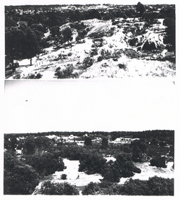
... ... Mining Areas...Two of the photos are scenes of mining areas, one has bush, buildings and poppet legs and one is a view of the town area taken from a lookout. ...Two of the photos are scenes of mining areas, one has bush, buildings and poppet legs and one is a view of the town area taken from a lookout. ...Two pages of photocopies of photos, four of landscape photos and one of what looks like drums in a bunker. Two of the photos are scenes of mining areas, one has bush, buildings and poppet legs and one is a view of the town area taken from a lookout. There are two people leaning on the fence.bendigo, history, long gully history group, the long gully history group - landscape photos, mining areas -
 Linton and District Historical Society Inc
Photograph, Scotts, Sturt St, Ballarat, Devils Kitchen mine, 1920s
... Sepia photograph of rugged mining area....Sepia photograph of rugged mining area. Devils Kitchen mine, 1920s Photograph Scotts, Sturt St, Ballarat ...Sepia photograph of rugged mining area."Devils Kitchen 1920s".mines, devil's kitchen, piggoreet -
 Tarnagulla History Archive
Photograph: Men in a mining area, Men in a mining area, circa 1850 to 1920
... Photograph: Men in a mining area...Men in a mining area...Monochrome photograph depicting men in a mining area in or near Tarnagulla....Copy probably made by Murray Comrie in the 1960s. mining miners gold Monochrome photograph depicting men in a mining area in or near Tarnagulla. Men in a mining area Photograph: Men in a mining area ...Murray Comrie Collection. This is a dark copy of an older original. Copy probably made by Murray Comrie in the 1960s.Monochrome photograph depicting men in a mining area in or near Tarnagulla.mining, miners, gold -
 Lakes Entrance Historical Society
Book, Drew G J, Discovering Historic Burra, 1998
... A description of the historic copper mining area of Burra, South Australia with maps tourist trail photographs....Lakes Entrance Historical Society 4 Marine Parade Lakes Entrance gippsland Historic Sites Township Mines and Mining A description of the historic copper mining area of Burra, South Australia with maps tourist trail photographs. ...A description of the historic copper mining area of Burra, South Australia with maps tourist trail photographs.historic sites, township, mines and mining -
 Stawell Historical Society Inc
Photograph, Sloane's & Scotchmans Mining Co's Remains of Poppet Head, Chimney & Engine Mounts. 1928
... Damaged B/W image showing heavily eroded mining area with mine at centre distance. ...Stawell Historical Society Inc 46 Longfield St Stawell grampians Sloane's & Scotchman Mining Co remains Poppet Head Chimney and Engine Mounts. mining Panorama Damaged B/W image showing heavily eroded mining area with mine at centre distance. Sloane's & Scotchmans Mining Co's Remains of Poppet Head, Chimney & Engine Mounts. 1928 Photograph ...Sloane's & Scotchman Mining Co remains Poppet Head Chimney and Engine Mounts.Damaged B/W image showing heavily eroded mining area with mine at centre distance. mining, panorama -
Lakes Entrance Historical Society
Book, Walshe, Jemma, The Farm, 2004
... Research, interpretation and management recommendations for The Farm, and early mining area at Deptford, near Bairnsdale, East Gippsland, Victoria, by a Forestec student....Lakes Entrance Historical Society 4 Marine Parade Lakes Entrance gippsland Mines and Mining Schools Land Settlement Research, interpretation and management recommendations for The Farm, and early mining area at Deptford, near Bairnsdale, East Gippsland, Victoria, by a Forestec student. ...Research, interpretation and management recommendations for The Farm, and early mining area at Deptford, near Bairnsdale, East Gippsland, Victoria, by a Forestec student.mines and mining, schools, land settlement -
 Bendigo Historical Society Inc.
Photograph - MINING
... Mining . Bendigo Area. 40 Images....Mining Bendigo Mining . Bendigo Area. 40 Images. Photograph MINING ...Mining . Bendigo Area. 40 Images.mining, bendigo -
 Eltham District Historical Society Inc
Negative - Photograph, Carl Walter 1831-1907, Coffer dam in the Yarra River at Anderson's Creek, 1864
... mining...other areas...The last area in which gold was discovered was Kinglake. As the gold became harder to find, deep mining took over from alluvial diggings in the gullies. ...It is significant in being the first community sourced collection representing the places and people of the Shire's first one hundred years. shire of eltham pioneers photograph collection anderson's creek coffer dam floods gold mining other areas pioneers and painters warrandyte warrandyte bridge yarra river Digital image 4 x 5 inch B&W Neg (2) Print 20 x 25 cm Coffer dam in the Yarra River at Anderson's Creek Negative Photograph Carl Walter 1831-1907 ...1864 photograph of the Coffer Dam in the River Yarra situated (approximately) opposite Whipstick Gully. Remains of bridge built in 1860(?) wrecked by 1863 flood in background. Reproduced page 29 of ‘Pioneers & Painters’ Gold was first discovered in this area at Andersons Creek (Warrandyte) in June 1851 by Louis Michel. Discoveries north of the Yarra did not occur until about 1854. Although it took some months for a true rush to develop it was not long before alluvial workings were being carried on in most of the Shire of Eltham. The last area in which gold was discovered was Kinglake. As the gold became harder to find, deep mining took over from alluvial diggings in the gullies. Perhaps the most extensive of the deep workings was the Diamond Creek Mine just outside the boundary of the Shire. This form of mining was continued into the 1930s. There are believed to be some mines in the area still capable of producing gold but present prices make working these uneconomical. Some gold is still found by weekend prospectors. Photo: Carl Walter 1831-1907 – inscribed on tent “C. Walter Photo” The State Library of Victoria holds over 150 photos by Carl Walter, most of which are portraits of Aboriginal natives including William Barak.This photo forms part of a collection of photographs gathered by the Shire of Eltham for their centenary project book,"Pioneers and Painters: 100 years of the Shire of Eltham" by Alan Marshall (1971). The collection of over 500 images is held in partnership between Eltham District Historical Society and Yarra Plenty Regional Library (Eltham Library) and is now formally known as 'The Shire of Eltham Pioneers Photograph Collection.' It is significant in being the first community sourced collection representing the places and people of the Shire's first one hundred years.Digital image 4 x 5 inch B&W Neg (2) Print 20 x 25 cmshire of eltham pioneers photograph collection, anderson's creek, coffer dam, floods, gold mining, other areas, pioneers and painters, warrandyte, warrandyte bridge, yarra river -
 Federation University Historical Collection
Program, Booklet, Newspaper Cuttings, Map, Mount Lyell Contour Map
... Copy of a contour map of Mount Lyell, Tasmania, showing the mining areas of West Lyell, Glen Lyell. Gormanston, Cape Horn and Comstock....mount lyell tasmania contour map Copy of a contour map of Mount Lyell, Tasmania, showing the mining areas of West Lyell, Glen Lyell. Gormanston, Cape Horn and Comstock. ...Copy of a contour map of Mount Lyell, Tasmania, showing the mining areas of West Lyell, Glen Lyell. Gormanston, Cape Horn and Comstock.mount lyell, tasmania, contour map -
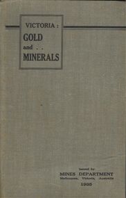 Bendigo Historical Society Inc.
Book - BOOK - VICTORIA: GOLD AND . . MINERALS
... This book gives in great detail about promising mining areas in Victoria along with detailed maps of them....This book gives in great detail about promising mining areas in Victoria along with detailed maps of them. ...A copy of the 1935 guide book Victoria: GOLD and MINERALS . This book gives in great detail about promising mining areas in Victoria along with detailed maps of them.book, bendigo, mining -
 Bendigo Historical Society Inc.
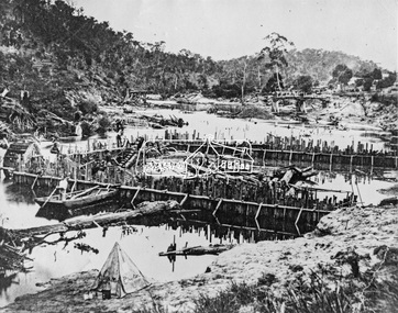
Photograph - MINING LANDSCAPE, 1861
... black and white photograph of mining area. Tents and slab buildings in background. ...History House 11 Mackenzie Street Bendigo goldfields PLACE Landscape view mining batchelder black and white photograph of mining area. Tents and slab buildings in background. ...black and white photograph of mining area. Tents and slab buildings in background. Man with horse at puddling machine, water pipe in right and centre. Man with horse waiting at left.batchelderplace, landscape view, mining -
 Coal Creek Community Park & Museum
Mine Map
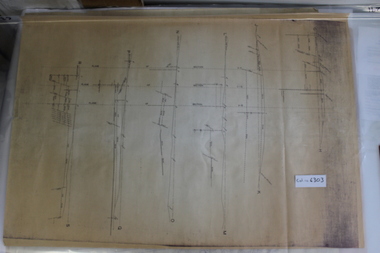
... 6303.1 - Cross sections of Korumburra coal mining area detailing local faulting and seam location/depth, boreholes, as well as elevation & surface topography along lines of sections....Coal Creek Community Park & Museum 12 Silkstone Road Korumburra gippsland 6303.1 - Cross sections of Korumburra coal mining area detailing local faulting and seam location/depth, boreholes, as well as elevation & surface topography along lines of sections. ...6303.1 - Cross sections of Korumburra coal mining area detailing local faulting and seam location/depth, boreholes, as well as elevation & surface topography along lines of sections. -
 Stawell Historical Society Inc
Photograph, The Reef Hotel Pleasant Creek 1858 - 1861 -- note, no Bullock team as in Rees painting
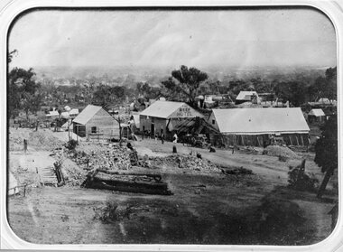
... Several buildings in mining area with trees in background, one building labelled The Reefs Hotel. ...One of earliest known photographs of Pleasant Creek Stawell Several buildings in mining area with trees in background, one building labelled The Reefs Hotel. ...The Reefs Hotel Pleasant Creek. 1858 - 1861 (note, no Bullock team as in Rees painting) Three windlasses over mineshafts can be seen, two on the left and one in front of the assembly hall. Some horse driven Whims can be seen in the background above the Assembly Hall.One of earliest known photographs of Pleasant CreekSeveral buildings in mining area with trees in background, one building labelled The Reefs Hotel. Spoil heaps in foreground with other mining activities . Number of people visible in street.stawell -
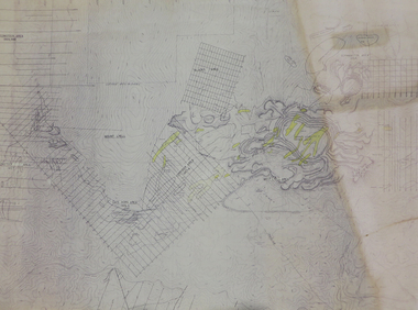
 Coal Creek Community Park & Museum
Mine Map
... 6306.1 - Map of Outtrim mining area, with modification where damage/erasure has occurred. ...Coal Creek Community Park & Museum 12 Silkstone Road Korumburra gippsland 6306.1 - Map of Outtrim mining area, with modification where damage/erasure has occurred. ...6306.1 - Map of Outtrim mining area, with modification where damage/erasure has occurred. Shows tunnels, faults, tramways, boreholes, surface roads and (apparently) paddock boundaries and a creek. -
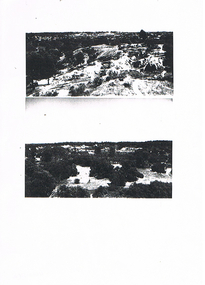
 Bendigo Historical Society Inc.
Photograph - LONG GULLY HISTORY GROUP COLLECTION: PHOTO OF MINING AREA
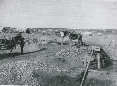
... LONG GULLY HISTORY GROUP COLLECTION: PHOTO OF MINING AREA...The Long Gully History Group - Photo of Mining Area...Copy of two black and white photos of a mining area. the top photo shows a hilly area with vegetation and a track and the lower photo shows a bush area with a fence? ...Photograph LONG GULLY HISTORY GROUP COLLECTION: PHOTO OF MINING AREA ...Copy of two black and white photos of a mining area. the top photo shows a hilly area with vegetation and a track and the lower photo shows a bush area with a fence? behind some shrubs in the foreground.bendigo, history, long gully history group, the long gully history group - photo of mining area -
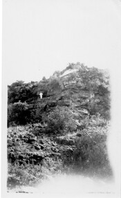
 Stawell Historical Society Inc
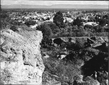
Photograph, Big Hill Area overlooking Stawell showing the mining area
... Big Hill Area overlooking Stawell showing the mining area...Scene from Big Hill Area overlooking Stawell showing mining area...Stawell Historical Society Inc 46 Longfield St Stawell grampians Scene from Big Hill Area overlooking Stawell showing mining area stawell Big Hill Area overlooking Stawell showing the mining area Photograph ...Scene from Big Hill Area overlooking Stawell showing mining areastawell -
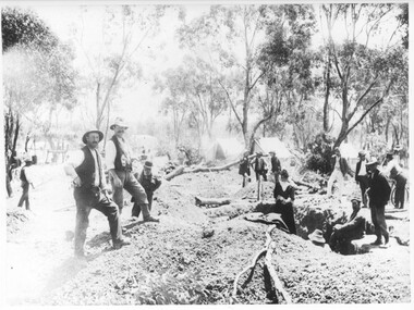
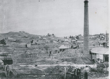
 Bendigo Historical Society Inc.
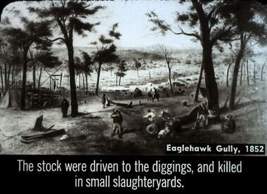
Slide - DIGGERS & MINING. STORES AT THE DIGGINGS, c1852
... The Stock were driven to the diggings, and killed in small slaughter yards. Slide shows mining area at Eaglehawk Gully. Markings: 24 994.LIF. 5. ...The Stock were driven to the diggings, and killed in small slaughter yards. Slide shows mining area at Eaglehawk Gully. Markings: 24 994.LIF. 5. ...Diggers & Mining. Stores at the diggings. Eaglehawk Gully, 1852. The Stock were driven to the diggings, and killed in small slaughter yards. Slide shows mining area at Eaglehawk Gully. Markings: 24 994.LIF. 5. Used as a teaching aid.hanimounteducation, tertiary, goldfields -
 Buninyong Visitor Information Centre
Document (item) - Folio, Buninyong Visitor Information Centre Volunteers, Mining in the Buninyong Area, 1990s
... Mining in the Buninyong Area...Includes names of mining companies in the area and maps showing locations of mines. ...Includes 29 maps, tables and notes on mining in the Buninyong area....Includes 29 maps, tables and notes on mining in the Buninyong area. Mining in the Buninyong Area Document Folio Buninyong Visitor Information Centre Volunteers ...Includes names of mining companies in the area and maps showing locations of mines. mining, gold mining, buninyong, industry -
 Stawell Historical Society Inc
Photograph, First known photograph of The Reefs and Reef Hotel Pleasant Creek with a bullock team in front 1858 -1861
... Several buildings in mining area with trees in background, one building labelled The Reefs Hotel. ...Stawell Hotel Several buildings in mining area with trees in background, one building labelled The Reefs Hotel. ...B/W Photo The Reefs Hotel and Assembly Hall Pleasant Creek with Bullock team in front. 1858 -1861 Three windlasses over mineshafts can be seen, two on the left and one in front of the assembly hall. Some horse driven Whims can be seen in the background above the Assembly Hall. This hotel was built right among the mines in upper Main Street. The first licence was held by William Pond in 1858. Robert Young in 1859 and John Steele in 1861. It had a short life as only rates were paid in 1862.Earliest known photograph of the Reefs Pleasant Creek.Several buildings in mining area with trees in background, one building labelled The Reefs Hotel. Spoil heaps in foreground with other mining activities and with bullock team and cart. Man can be seen standing on slab hut roof at centre and woman in street. stawell, hotel -
Lakes Entrance Historical Society
Book - Family/Local History, Bates Bob, Lucy Strobridge, Maid of the Mountains, 2003
... A sympathetic account of the life of Lucy Strobridge a woman who lived in isolation in the bush in the old Brookville mining area, Swifts Creek being the closest permanent township. ...Settlers Mines and Mining Genealogy A sympathetic account of the life of Lucy Strobridge a woman who lived in isolation in the bush in the old Brookville mining area, Swifts Creek being the closest permanent township. ...A sympathetic account of the life of Lucy Strobridge a woman who lived in isolation in the bush in the old Brookville mining area, Swifts Creek being the closest permanent township. The author gives an account of Lucy's family history, and the history of Brookville and the surrounding district. settlers, mines and mining, genealogy -
 Bendigo Historical Society Inc.
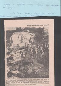
Newspaper - VICTORIA HILL - NEWSPAPER PHOTO - VICTORIA HILL
... Black & white newspaper photo of part of the Victoria Hill Mining Area. There are a number of school children in the photo. ...Richardson, president of Bendigo Historical Society, led a party of children from Parkmoor, Heatherdale and Forest Hill Primary Schools over mining areas and spoke on the mining industry. ...Black & white newspaper photo of part of the Victoria Hill Mining Area. There are a number of school children in the photo. On the left are old car bodies. Behind them is a rocky area and behind that is a house with three chimneys. In the foreground is more rock, some with netting over it. Mr A. E. Richardson, president of Bendigo Historical Society, led a party of children from Parkmoor, Heatherdale and Forest Hill Primary Schools over mining areas and spoke on the mining industry. The photo was in the Bendigo Advertiser, Sat. May 2, 1970. Article part of Albert Richardson collection of mining documents.mine, gold, victoria hill, victoria hill, victoria hill newspaper photo, mr a e richardson -
 Tatura Irrigation & Wartime Camps Museum
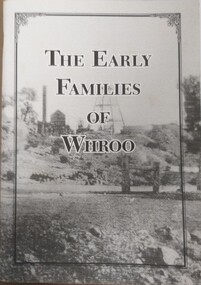
Booklet, The Early Families of Whroo
... Tells a short story of the early families who settled at Whroo, a gold mining area, located near Rushworth. The town is no long in existence. ...Tatura Irrigation & Wartime Camps Museum 49 Hogan Street Tatura the-murray Tells a short story of the early families who settled at Whroo, a gold mining area, located near Rushworth. The town is no long in existence. ...Tells a short story of the early families who settled at Whroo, a gold mining area, located near Rushworth. The town is no long in existence. Written by Doris KIngA5 size booklet with soft cardboard cover. Cover has a black frame in from the edge with the book title in that in black print. Cover is a grey scale photograph of the Whroo mining site. 88 pages.titlewhroo, families of whroo, doris king -
 Bendigo Historical Society Inc.
Document - RAMBLING AROUND
... Type written account of a walk around some of the old mining areas of Bendigo. Areas mentioned are: Rose St, New Chum Gully, Barnard St, New Chum Hill, Sterry's Open Cut, Gold Mines Hotel, Inglewood St, Chum St, Maple St, Philip's Hill, Puddling Machine,...History House 11 Mackenzie Street Bendigo goldfields DOCUMENT Names of bendigo pioneers bendigo goldfields Rambling Around Len Bennetts Joch Garibaldi Mine and Battery Menzies Ellesmere South Old Chum New Chum Con Nth Ellesmere New Chum United Lansells 222 Fortuna Lazarus Nell Gwynne (BML) Fortuna Mr Geo Lansell Old Chum BCV 8 Sterry's Open Cut Gold Mines Hotel Gill's Grocer Shop Mr Gill Moorshead's Foggitt and Jones Hill Type written account of a walk around some of the old mining areas of Bendigo. Areas mentioned are: Rose St, New Chum Gully, Barnard St, New Chum Hill, Sterry's Open Cut, Gold Mines Hotel, Inglewood St, Chum St, Maple St, Philip's Hill, Puddling Machine, Document RAMBLING AROUND ...Type written account of a walk around some of the old mining areas of Bendigo. Areas mentioned are: Rose St, New Chum Gully, Barnard St, New Chum Hill, Sterry's Open Cut, Gold Mines Hotel, Inglewood St, Chum St, Maple St, Philip's Hill, Puddling Machine,document, names of bendigo pioneers, bendigo goldfields, rambling around, len bennetts, joch, garibaldi mine and battery, menzies, ellesmere, south old chum, new chum con, nth ellesmere, new chum united, lansells 222, fortuna, lazarus, nell gwynne (bml), fortuna, mr geo lansell, old chum, bcv 8, sterry's open cut, gold mines hotel, gill's grocer shop, mr gill, moorshead's, foggitt and jones hill -
Federation University Historical Collection
Formulae Mine Surveying
... Formulae for the various calculations involved in Mining Surveying - areas, volumes, weights, chain strength, loads, Columns, angles, side lengths...Barker Library (top floor) Mount Helen goldfields mine surveying survey Formulae for the various calculations involved in Mining Surveying - areas, volumes, weights, chain strength, loads, Columns, angles, side lengths Formulae Mine Surveying ...Formulae for the various calculations involved in Mining Surveying - areas, volumes, weights, chain strength, loads, Columns, angles, side lengthsmine surveying, survey -
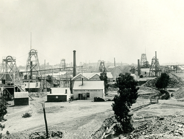
 Bendigo Historical Society Inc.
Photograph - DEVONSHIRE GROUP OF MINES
... black and white photograph, view across mining area showing at least 9 poppet heads. ...History House 11 Mackenzie Street Bendigo goldfields BUILDINGS Commercial devonshire group of mines black and white photograph, view across mining area showing at least 9 poppet heads. At least 11 chimneys and many buildings associated with the mines. ...black and white photograph, view across mining area showing at least 9 poppet heads. At least 11 chimneys and many buildings associated with the mines. Centre to left, flume, wood stacks, mullock heaps. In image ' Duchess Tribute' on weatherboard building at centre. On back '12' Devonshire gorup' in ball point pen. MNG 1.buildings, commercial, devonshire group of mines -
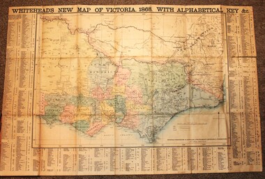 Wodonga & District Historical Society Inc
Map - Whiteheads New Map of Victoria, E. Whitehead & Co., engravers & lithographers, 1868
... It also shows roads, post office towns, railways, telegraphs, gold mining areas and notes on topography. Relief shown by hachures and spot heights. ...It also shows roads, post office towns, railways, telegraphs, gold mining areas and notes on topography. Relief shown by hachures and spot heights. ...Edward Whitehead was a printer and publisher active in Melbourne during the latter half of the 19th century. Whitehead founded his printing business at 67 Collins Street East in 1864 and, though not focused on maps, began publishing his own series of maps of Victoria in 1867. He focussed on producing highly detailed folding maps of Victoria which included a very detailed index of place names. His series of maps of Victoria became one of the most successful and most profitable series of regional maps of Australia ever produced.This is a very early map of Victoria showing Belvoir (Wodonga)A detailed early map of Victoria with counties clearly marked and shaded and a detailed index. It also shows roads, post office towns, railways, telegraphs, gold mining areas and notes on topography. Relief shown by hachures and spot heights. Includes a list of towns with distances from Melbourne on 3 sides of map. It is produced on paper mounted on linen.victoria cartography, rare maps victoria, whiteheads maps -
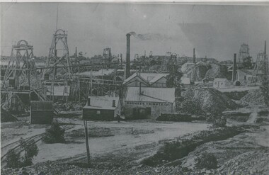
 Bendigo Historical Society Inc.
Photograph - DEVONSHIRE GROUP OF MINES,1896
... Black and white photograph. View across mining area showing at least 9 poppet heads, 11 chimneys and many buildings associated with the mines. ...History House 11 Mackenzie Street Bendigo goldfields PLACE Mining site see also 2000.426.01 2000.437.01 2000.438.01 2000.439.01 2000.504.01 2000.507.01 2000.508.01 James Lerk 26/11/1999 Black and white photograph. View across mining area showing at least 9 poppet heads, 11 chimneys and many buildings associated with the mines. ...Black and white photograph. View across mining area showing at least 9 poppet heads, 11 chimneys and many buildings associated with the mines. C to L - flume, wood stacks, mullock heaps. Inscription in image 'Duchess Tribute' on weatherboard building at C. On back, blue circular stamp 'Historical Society of Victoria, Bendigo Branch', 'MP 264'.James Lerk 26/11/1999place, mining site, see also 2000.426.01, 2000.437.01, 2000.438.01, 2000.439.01, 2000.504.01, 2000.507.01, 2000.508.01 -
 Bendigo Historical Society Inc.
Photograph - MINING LANDSCAPE, 1861
... black and white photograph: view of mining area. From left to right, portion of cart, hut, houses and huts, whims, small houses, houses on skyline. ...History House 11 Mackenzie Street Bendigo goldfields PLACE Landscape view mining batchelder black and white photograph: view of mining area. From left to right, portion of cart, hut, houses and huts, whims, small houses, houses on skyline. ...black and white photograph: view of mining area. From left to right, portion of cart, hut, houses and huts, whims, small houses, houses on skyline. Tall brick chimney at right with wood and corrugated iron roof buildings. 2 carts at front right. 2 males front right. Small houses at background right. Location unknown.batchelderplace, landscape view, mining -
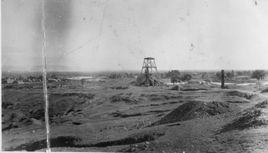
 Bendigo Historical Society Inc.
Photograph - LITTLE 180 MINE, 1920 / 1933
... Initially named Lansells Little 180 Mine was part of the Victoria Hill mining area. It was operated by George Lansell until his death in 1906 but continued operation by his estate until 1927 when it was sold. ...History House 11 Mackenzie Street Bendigo goldfields Initially named Lansells Little 180 Mine was part of the Victoria Hill mining area. It was operated by George Lansell until his death in 1906 but continued operation by his estate until 1927 when it was sold. ...Initially named Lansells Little 180 Mine was part of the Victoria Hill mining area. It was operated by George Lansell until his death in 1906 but continued operation by his estate until 1927 when it was sold. The mine closed in the early 1930's.black And white photo - 2 adult males in foreground, 1 wearing hat, waiscoat, 1 wearing hat, 3 piece suit. Corrugated iron building behind men with double wooden doors, wooden shutters as windows, large wooden reel ( for cable ) at right. Saw horse at left foreground. On back ' Mine Manager/Little 180 Bendigo/1920.'cottage, miners -
 Kew Historical Society Inc
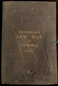
Map, Whitehead's Map of Victoria, With Alphabetical Key, 1869, 1869
... Map of Victoria with gold mining areas, notes on topography, transport routes. ...In addition to its historical significance, this is a rare map, of which the only known copies in Australian public collections are those held at the National Library of Australia, the State Library of Victoria, State Library of New South Wales and the University of Queensland Library. maps - victoria - 1860s e whitehead's new map of victoria 1869 whitehead's map of victoria with alphabetical key 1869 cartography gold rush Cover "WHITEHEAD'S NEW MAP OF VICTORIA 1869" Map of Victoria with gold mining areas, notes on topography, transport routes. ...When E. Whitehead's New Map of Victoria was released in 1869, an advertisement in the Bendigo Advertiser (16 July 1869) noted that: "This beautifully engraved Map has been revised and brought down to the present time; and, with the Alphabetical Key, is the most complete and the cheapest Map ever published; Price, 6d plain; 1s colored; 2s 6d in case; on linen, post free, 2d extra. E.. WHITEHEAD and CO, Publishers, 67 Collins-street east." The following year, 1870, Whitehead's promoted the edition in the Portland Guardian and Normanby General Advertiser (3 January 1870), advising that: "WHITEHEAD'S NEW MAP OF VICTORIA, 1869 ... is corrected to the latest date, and around is arranged an Alphabetical Key, with Post Towns and Money Order Olffices marked. The Map being divided into squares and numbered, by reference to the Key any place can be found immediately. Price Is beautifully colored, or mounted on linen in case, 2s 6d. Post free, 2d extra, in Victoria. B. Whitehead and C0., Puolishers, 67 Collins-street East, Melbourne". In the same edition of the Portland Advertiser, they also promoted their business generally, saying: "E WHITEHEAD and Co., Stationers, Engravers, Lithographers, 67 Collins street East, execute every description of Lithographic PRINTING, BILL-HEADS. NOTE Headings. Business Dies Engraved and Embossed on Envelopes &c. ARMS, MONOGRAMS, AND CRESTS Engraved and Embossed in Colour, superior to any other house in the Colony. Specimens, post free, 2d. Lithographers, &c, to H.R.H. the Duke of Edinburgh, and Die-inkers and Embossers to His Excellency Sir J. H. T. Manners-Sutton, K C.B. Orders executed for the Trade". Whitehead’s New Map of Victoria 1869 is is an important record of region created towards the end of the Victorian Gold Rush (1851-1869). In addition to its historical significance, this is a rare map, of which the only known copies in Australian public collections are those held at the National Library of Australia, the State Library of Victoria, State Library of New South Wales and the University of Queensland Library.Map of Victoria with gold mining areas, notes on topography, transport routes. Relief shown by hachures. List of towns with distance from Melbourne in map margin. [Melbourne] : Printed & Published by ... E Whitehead & Co ... 67 Collins Street East, 1869 1 map : col., mounted on linen ; 38.4 x 55.4 cm, folded to 18 x 12 cm.Cover "WHITEHEAD'S NEW MAP OF VICTORIA 1869"maps - victoria - 1860s, e whitehead's new map of victoria 1869, whitehead's map of victoria with alphabetical key 1869, cartography, gold rush