Showing 102 items matching " mining landscape"
-
 Bendigo Historical Society Inc.
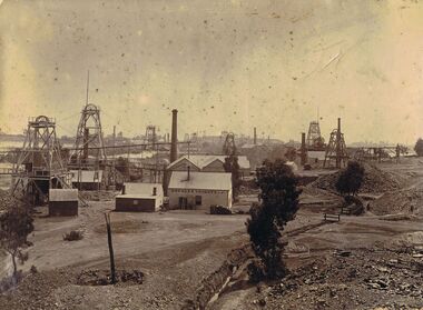
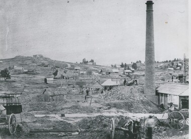
Photograph - MINING LANDSCAPE BENDIGO - CALIFORNIA GULLY AREA
... MINING LANDSCAPE BENDIGO - CALIFORNIA GULLY AREA...Mining...landscape view...Sepia image: mounted on board, shows mining landscape with numerous poppet heads and mining chimneys visible. ...History House 11 Mackenzie Street Bendigo goldfields BENDIGO Mining landscape view Sandhurst Bendigo Duches Tribute poppet heads chimneys Sepia image: mounted on board, shows mining landscape with numerous poppet heads and mining chimneys visible. ...Sepia image: mounted on board, shows mining landscape with numerous poppet heads and mining chimneys visible. In forefront of image: Shed with 'Duchess Tribute' written on front, small cottage alongside, poppet head on LH side and another immediately behind, various sheds. Written on bottom of photo in blue pen: Golden Square. (is not Golden Square view but California Gully on New Chum Line of reef )bendigo, mining, landscape view, sandhurst, bendigo, duches tribute, poppet heads, chimneys -
 Bendigo Historical Society Inc.
Photograph - WES HARRY COLLECTION: MINING LANDSCAPE BENDIGO
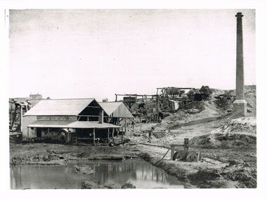
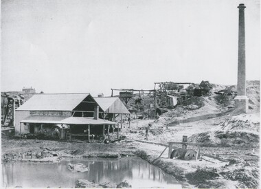
... WES HARRY COLLECTION: MINING LANDSCAPE BENDIGO......mining landscape...Photograph WES HARRY COLLECTION: MINING LANDSCAPE BENDIGO ...Black and white photo copy : image shows line of whims descending towards open shed like building in front of mining dam. On RH side brick chimney. Potentially, the same area as shown in image 2402.237 (see mine sheds, brick chimney and whims).Batchelderplace, bendigo, mining landscape -
 Bendigo Historical Society Inc.
Photograph - WES HARRY COLLECTION: MINING LANDSCAPE BENDIGO
... WES HARRY COLLECTION: MINING LANDSCAPE BENDIGO......mining landscape...Photograph WES HARRY COLLECTION: MINING LANDSCAPE BENDIGO ...Black and white photo copy: image shows heavily mined landscape, buildings (stone ? ) on RH side, brick chimney behind, line of whims heading to hill top along reef line.Batchelderplace, bendigo, mining landscape, bendigo, sandhurst, goldmining, gold -
 Bendigo Historical Society Inc.
Photograph - MINING LANDSCAPE, 1861
... MINING LANDSCAPE......Landscape view...mining...Man with horse waiting at left. Photograph MINING LANDSCAPE ...black and white photograph of mining area. Tents and slab buildings in background. Man with horse at puddling machine, water pipe in right and centre. Man with horse waiting at left.batchelderplace, landscape view, mining -
 Bendigo Historical Society Inc.
Photograph - MINING LANDSCAPE, 1861
... MINING LANDSCAPE......Landscape view...mining...Location unknown. Photograph MINING LANDSCAPE ...black and white photograph: view of mining area. From left to right, portion of cart, hut, houses and huts, whims, small houses, houses on skyline. Tall brick chimney at right with wood and corrugated iron roof buildings. 2 carts at front right. 2 males front right. Small houses at background right. Location unknown.batchelderplace, landscape view, mining -
 Bendigo Historical Society Inc.
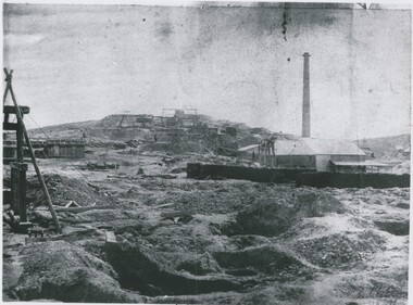
Photograph - MINING LANDSCAPE, 1961
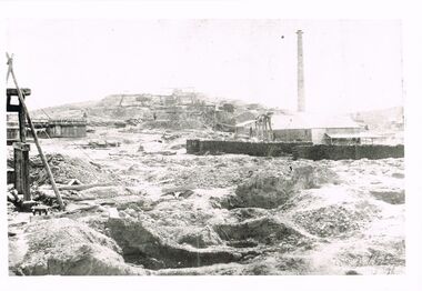
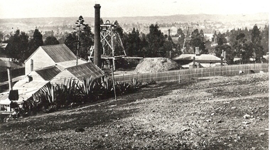
... MINING LANDSCAPE......Landscape view...mining...) on hill in distance. Photograph MINING LANDSCAPE ...black and white photo: unknown mining site. Left to right, shed with multiple boilers, horse whims with horse ( background ) Chilean mill ( foreground ) Chimney. In foreground, dam with 'filter' Substantial house ( stone ? ) on hill in distance.Batchelder, Sandhurstplace, landscape view, mining site -
 Bendigo Historical Society Inc.
Photograph - MINING LANDSCAPE, 1861
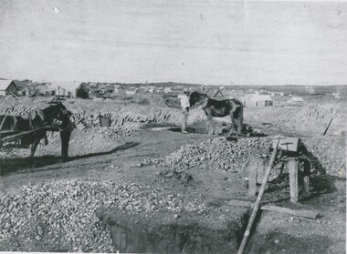
... MINING LANDSCAPE...Landscape view...mining...A. frame and timber structure at centre left, mullock dumps. Photograph MINING LANDSCAPE ...Black and white photo: alluvial diggings in foreground, wheelbarrow, centre field, stone building with galvanised iron roof with chimney at rear. 2 stacks of 6 foot timber for boiler. Headframe in front. Man standing under shelter near head frame. Midground, left tank of vertical plants. Hill with 5 whims to rear. A. frame and timber structure at centre left, mullock dumps.batchelderlandscape view, mining -
 Bendigo Historical Society Inc.
Photograph - BASIL MILLER COLLECTION: MINING LANDSCAPE - NEW CHUM GULLY, BENDIGO, 1860-70's
... BASIL MILLER COLLECTION: MINING LANDSCAPE - NEW CHUM GULLY, BENDIGO...Black and white copy of landscape showing many poppet heads, mining activity in New Chum Gully, Bendigo. ...Photograph BASIL MILLER COLLECTION: MINING LANDSCAPE - NEW CHUM GULLY, BENDIGO ...BHS CollectionBlack and white copy of landscape showing many poppet heads, mining activity in New Chum Gully, Bendigo. Fortuna Villa visible on ridge line, rear of photo. Horse and covered cart in foreground.unknownperson, individual, basil miller -
 Bendigo Historical Society Inc.
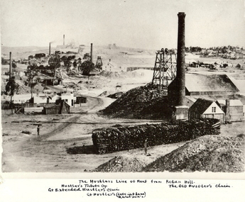
Photograph - HUSTLER'S LINE OF REEF
... mining... landscape...Black and white photograph of mining landscape with poppet head, chimney and mining sheds (plus timber in stack) in foreground. ...History House 11 Mackenzie Street Bendigo goldfields BHS Collection MINE Gold hustlers reef mine Bendigo mines and mining mine mines mining landscape mining landscape Redan Hill poppet head Old Hustlers mining cottages Black and white photograph of mining landscape with poppet head, chimney and mining sheds (plus timber in stack) in foreground. ...BHS CollectionBlack and white photograph of mining landscape with poppet head, chimney and mining sheds (plus timber in stack) in foreground. Other mines in bare landscape on LHS background and housing on RHS background. Inscriptions: on front - 'The Hustler's Line of Reef from Redan Hill Hustler's Tribute Coy', 'Gt. Extended Hustler;s Claim', 'The Old Hustler's Claim, Gt. Hustlers (Late Latham & Watson's). On back - 'A Richardson, 29 Harrison Street, Bendigo'.mine, gold, hustlers reef mine, bendigo, mines and mining, mine, mines, mining, landscape, mining landscape, redan hill, poppet head, old hustlers, mining cottages -
 Bendigo Historical Society Inc.
Photograph - WES HARRY COLLECTION: LANDSCAPE VIEW OF MINING
... WES HARRY COLLECTION: LANDSCAPE VIEW OF MINING......mining landscape...Black and white photo copy: image shows mining landscape, large chimney in front right hand side, slab timber buildings on individual shaft sites, mining cottages, very sparse landscape. ...History House 11 Mackenzie Street Bendigo goldfields PLACE Bendigo mining landscape Bendigo Sandhurst goldmining gold New Chum Hill Hustlers Hill Batchelder Black and white photo copy: image shows mining landscape, large chimney in front right hand side, slab timber buildings on individual shaft sites, mining cottages, very sparse landscape. ...Black and white photo copy: image shows mining landscape, large chimney in front right hand side, slab timber buildings on individual shaft sites, mining cottages, very sparse landscape. Whims in centre. Horse and carts . Two men tipping an ore bin on right hand side near chimney. Landscape could be looking to either New Chum Hill or Hustler's Hill, Bendigo.Batchelderplace, bendigo, mining landscape, bendigo, sandhurst, goldmining, gold, new chum hill, hustlers hill -
 Bendigo Historical Society Inc.
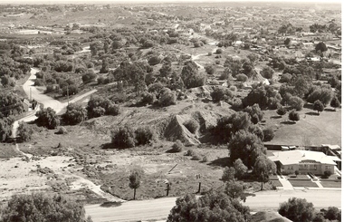
Photograph - VIEW OF MINING AREA - VICTORIA HILL
... mining... landscape...History House 11 Mackenzie Street Bendigo goldfields PLACE Mining site victoria hill Bendigo mines and mining landscape mining landscape mullock heaps Robert Wallace Black and white photograph. ...Black and white photograph. View overlooking north from Victoria Hill, mullock heaps, houses - some mid to late 20th century and some miner's cottages, formed road, children's playground centre foreground. Inscriptions: on back - purple rubber stamp 'Robert Wallace Studios, 6 Ruth Street, Golden Square, Phone Bgo 37565.Robert Wallaceplace, mining site, victoria hill, bendigo, mines and mining, landscape, mining landscape, mullock heaps -
 Bendigo Historical Society Inc.
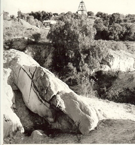
Photograph - MINE WORKINGS, ROCK OUTCROP
... ...mining landscape...History House 11 Mackenzie Street Bendigo goldfields MINE Gold mining landscape Bendigo mines and mining mines mine mining landscape Victoria Hill Robert Wallace Studios, Golden Square Black and white photo: large rock outcrop and mine working on treed hill in foreground. ...Black and white photo: large rock outcrop and mine working on treed hill in foreground. House in middle ground and poppet head on hilltop horizon. Victoria Hill area ? On back Wallace Studios/6 Ruth St.,/ Golden Square/ Phone Go 37565Robert Wallace Studios, Golden Squaremine, gold, mining landscape, bendigo, mines and mining, mines, mine, mining, landscape, victoria hill -
 Bendigo Historical Society Inc.
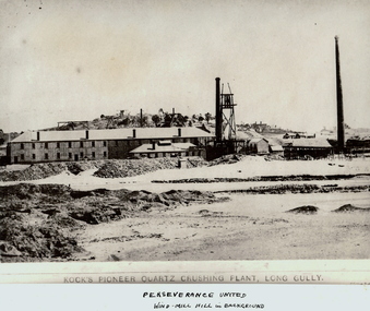
Photograph - KOCK'S PIONEER QUARTZ CRUSHING PLANT
... ... mining landscape...History House 11 Mackenzie Street Bendigo goldfields MINING Crushing & milling kock's pioneer quartz crushing plant Bendigo mines and mining mines mine mining crushing plant landscape mining landscape quartz perserverance united windmill Black and white photograph. ...Black and white photograph. View of large mining plant and associated chimneys. Open (waste) area in foreground. Low hill in background. Inscriptions: on front 'Kock's Pioneer Quartz Crushing Plant, Long Gully', Perserverance United Windmill Hill in background'. On back - 'A Richardson, 29 Harrison St, Bendigo'.mining, crushing & milling, kock's pioneer quartz crushing plant, bendigo, mines and mining, mines, mine, mining, crushing plant, landscape, mining landscape, quartz, perserverance united windmill -
 Bendigo Historical Society Inc.
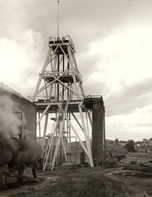
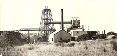
Photograph - HERCULES MINE A152
... ... mining landscape...History House 11 Mackenzie Street Bendigo goldfields MINING Surface equipment Hercules Mine Bendigo mines and mining mines mine landscape mining landscape poppet head horse and dray Black and white photograph. ...Black and white photograph. Poppet head, squared wooden legs & timpering, 2 vertical iron storage bins. 2 stage landings + access steps, Horse + Dray near storage bins compressed on tanks in foreground. Bailing tank near sky shaft suburban houses in distance winder house at the left front. Hercules Mine.mining, surface equipment, hercules mine, bendigo, mines and mining, mines, mine, landscape, mining landscape, poppet head, horse and dray -
 Bendigo Historical Society Inc.
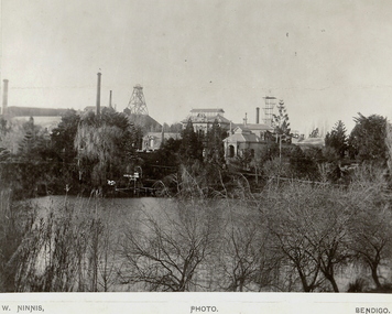
Photograph - FORTUNA COLLECTION: VIEW OF FORTUNA
... ... mining landscape...History House 11 Mackenzie Street Bendigo goldfields BUILDINGS Residential fortuna villa Bendigo mines and mining mine mines mining poppet head Old Chum mine landscape mining landscape Black and white photograph of Fortuna with lake in foreground. ...Black and white photograph of Fortuna with lake in foreground. Poppet head and chimneys in background. Inscriptions: on front - 'W Ninnis' Photo Bendigo. Inscription on back: 'Old Chum Mine - New Chum Hill. Taken from rear, Lansell's Fortuna lake.' A. Richardson, 29 Harrison St., Bendigo.buildings, residential, fortuna villa, bendigo, mines and mining, mine, mines, mining, poppet head, old chum mine, landscape, mining landscape -
 Bendigo Historical Society Inc.
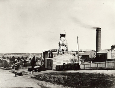
Photograph - MINE WINDER HOUSE
... ... mining landscape...History House 11 Mackenzie Street Bendigo goldfields Surface equipment surface site Bendigo mines and mining mine mining poppet head transport dray mining landscape landscape Black and white photograph. ...Black and white photograph. Mine winder house, poppet head, ore bins, chimney and shed. Residences adjacent to mine and streets. Poppet heads visible in far background. surface equipment, surface site, bendigo, mines and mining, mine, mining, poppet head, transport, dray, mining landscape, landscape -
 Bendigo Historical Society Inc.
Photograph - DEBORAH REEF GOLD MINE, 20/03/1937
... mining... landscape...History House 11 Mackenzie Street Bendigo goldfields MINE Gold central deborah gold mine mines and mining poppet head Bendigo mines mining landscape Black and white photograph. Poppet head, buildings of Deborah Reef Gold Mine. ...Black and white photograph. Poppet head, buildings of Deborah Reef Gold Mine. Inscriptions: on back - hand-written in ink 'Deborah Reef Gold Mines p/l', '20.3.37'. Written on back 'Royal Historical Society, Bendigo Branch'.mine, gold, central deborah gold mine, mines and mining, poppet head, bendigo, mines, mining, landscape -
![View of the township of Golden Square / [by] Nicholas Caire, circa 1876](/media/collectors/550653872162f11fb04854aa/items/578340aed0cdd1176c6899f4/item-media/5783411dd0cdd1176c68c568/item-fit-380x285.jpg?cb=6) Kew Historical Society Inc
Kew Historical Society IncPhotograph, Anglo-Australasian Photographic Company, View of the township of Golden Square, c. 1876
... mining...landscape photography - victoria...His vision of the Australian bush and pioneer life had a counterpart in the works of Henry Lawson and other nationalist poets, authors and painters. nicholas caire (1837-1918) golden square (vic) bendigo (vic) gold mining landscape photography - victoria On Reverse: ‘This Township is situated in the Bendigo district, on the road to Castlemaine, and although it is of little importance as a business town, is nevertheless of large importance in consequence of the great number of Quartz Reefs it contains. ...Nicholas Caire was born on Guernsey in the Channel Islands in 1837. He arrived in Adelaide with his parents in about 1860. In 1867, following photographic journeys in Gippsland, he opened a studio in Adelaide. From 1870 to 1876 he lived and worked in Talbot in Central Victoria. In 1876 he purchased T. F. Chuck's studios in the Royal Arcade Melbourne. In 1885, following the introduction of dry plate photography, he began a series of landscape series, which were commercially successful. As a photographer, he travelled extensively through Victoria, photographing places few of his contemporaries had previously seen. He died in 1918. Reference: Jack Cato, 'Caire, Nicholas John (1837–1918)', Australian Dictionary of Biography.An original, rare photograph from the series 'Views of Victoria: General Series' by the photographer, Nicholas Caire (1837-1918). The 60 photographs that comprise the series were issued c. 1876 and reinforced a neo-Romantic view of the Australian landscape to which a growing nationalist movement would respond. Nicholas Caire was active as a photographer in Australia from 1858 until his death in 1918. His vision of the Australian bush and pioneer life had a counterpart in the works of Henry Lawson and other nationalist poets, authors and painters.‘View of the township of Golden Square’ : Views of Victoria (General Series) No.57 : Albumen silver photograph | Photo on card with Title and Description on reverse | Mounted 24 x 30 cm; Photo 12 x 17 cm.On Reverse: ‘This Township is situated in the Bendigo district, on the road to Castlemaine, and although it is of little importance as a business town, is nevertheless of large importance in consequence of the great number of Quartz Reefs it contains. Almost every house is undermined, and large fortunes have been made by the proprietors. The Church in the distance is that of the Wesleyan body. It was in this township that gold was first discovered in the district of Bendigo.’nicholas caire (1837-1918), golden square (vic), bendigo (vic), gold mining, landscape photography - victoria -
 Bendigo Historical Society Inc.
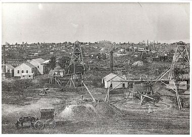
Photograph - VIEWS OF VICTORIA NO 13
... North Old Chum, New Chum and Victoria Companies. Mining landscape...North Old Chum, New Chum and Victoria Companies. Mining landscape Photograph VIEWS OF VICTORIA NO 13 ...Views of Victoria No 13. View of Victoria Hill Bendigo taken from Old Chum Hill. North Old Chum, New Chum and Victoria Companies. Mining landscapevictoria hill, old chum hill, new chum, north old chum, views of bendigo -
 Bendigo Historical Society Inc.
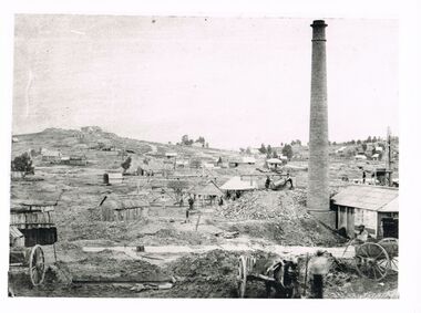
Photograph - MINE SITE
... Black and white photograph of the Hustler's Mine as a part of the Bendigo mining landscape with the valley in the background. ...History House 11 Mackenzie Street Bendigo goldfields BHS Collection BENDIGO Mining hustler's royal reserve mine Bendigo mines and mining mines mining gold mining gold gold mines place Bendigo mines Black and white photograph of the Hustler's Mine as a part of the Bendigo mining landscape with the valley in the background. ...BHS CollectionBlack and white photograph of the Hustler's Mine as a part of the Bendigo mining landscape with the valley in the background. On the left hand side is the poppet head, chimney and mining sheds and in the foreground is the bare stony earth.bendigo, mining, hustler's royal reserve mine, bendigo, mines and mining, mines, mining, gold mining, gold, gold mines, place, bendigo mines -
 Bendigo Historical Society Inc.
Photograph - MINE SITE
... mining... poppet head... landscape...History House 11 Mackenzie Street Bendigo goldfields MINING Surface equipment surface site Bendigo mines and mining mines mine mining poppet head landscape mining town Black and white photograph : view of mine workings in foreground - two poppet heads, building and chimney. ...Black and white photograph : view of mine workings in foreground - two poppet heads, building and chimney. Town ( housing ) in background. Chimney at bottom right with pointed top.mining, surface equipment, surface site, bendigo, mines and mining, mines, mine, mining, poppet head, landscape, mining town -
 The Beechworth Burke Museum
Photograph, 1960
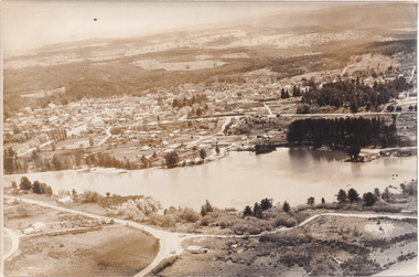
... ...australian landscape...Mining...mining site until the early 1900s, which brought Europeans into the area. It was turned into a reserve for residents in 1920 and is considered an icon of Beechworth as it represents the development of the community, human endeavour, and the spirit of the landscape....Lake Sambell #beechworth Beechworth 1960s Lake Victoria australian landscape Mining Rocky Mountain Mining Company Black and white reproduced rectangular photograph print on paper. ...Taken in 1960, depicted is an aerial view of Lake Sambell and the surrounding township. Lake Sambell is a beautiful Victorian recreation lake and urban park with a unique history. It was created in the mid-1800s by the Rocky Mountain Mining company during the gold rush era and used as a mining site until the early 1900s, which brought Europeans into the area. It was turned into a reserve for residents in 1920 and is considered an icon of Beechworth as it represents the development of the community, human endeavour, and the spirit of the landscape.This photograph represents what Lake Sambell looked like in 1960.Black and white reproduced rectangular photograph print on paper.lake sambell, #beechworth, beechworth 1960s, lake, victoria, australian landscape, mining, rocky mountain mining company -
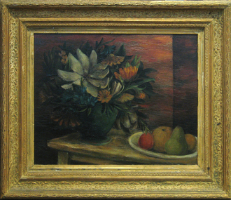 Federation University Art Collection
Painting - Oil, et al, [The Green Vase] by David Strachan, c1948
... Perhaps the most moving works of Strachan's last ten years were the mining landscapes, including those he painted near Hill End, leading up to his vast canvas, 'Lewers Freehold Mine'. ...Perhaps the most moving works of Strachan's last ten years were the mining landscapes, including those he painted near Hill End, leading up to his vast canvas, 'Lewers Freehold Mine'. ...David STRACHAN (1919–1970) Born 25 June 1919 at Salisbury, Wiltshire, England Arrived 1920 Adelaide, Australia: 1921 Creswick, Victoria David Strachan attended Creswick State School and Geelong Church of England Grammar school. By the age of 16 he wanted to be an artist. Accompanying his mother to London in 1936, he enrolled at the Slade School of Fine Art, where he met Godfrey Miller. In 1937 he attended the Académie de la Grande Chaumière, Paris, and painted at Cassis on the Mediterranean Sea. He returned to Australia in April 1938 and studied at the George Bell School, Melbourne. He had a growing interest in classicism blended with a fascination for the dream-state which was reinforced in his work after he moved to Sydney in 1941. There he was befriended by Jean Bellette and her husband Paul Haefliger, who were to be driving forces behind the Sydney Art Group (founded 1945). He lived on the top floor of the Haefligers' house at Double Bay, and together the three artists drew from models whom the Haefligers hired. In this period Strachan painted and exhibited some of his most poetic works—mainly figurative and landscape subjects, and still-lifes of haunting beauty. His flowers, bowls of fruit, birds, and angelic figures glimmered out of the darkness as things not of this world, evoked faintly, like mythological personages in a gently spoken narrative. He 'spent an erratic war' painting camouflage at Bankstown aerodrome with other artists, among them (Sir) William Dobell, and dancing minor roles with Hélène Kirsova's ballet company. In 1948 Strachan settled in Paris. His paintings, included by Peter Bellew in an exhibition at the Musée National d'Art Moderne, had been well-received by French critics two years earlier. In 1950 he began tentative experiments in etching. These led to the formation of the Stramur-Presse, a business venture which published etchings and lithographs of leading French and English artists. His most important project was a series of twenty-two colour etchings illustrating Alister Kershaw's book of poems, Accent & Hazard (Paris, 1951). Strachan continued to exhibit in Australia and maintained a lively social life with Australian friends. From Paris, he went for weekend painting trips with Moya Dyring in her car and, after 1957, visited the Haefligers on Majorca. He lived in London in 1955-57. His paintings became progressively less soft in effect, his palette brightened, and his forms, especially the still-lifes, became spikier. In the late 1950s his attention drifted towards the study of Hindu philosophers and Jungian psychology. For most of 1957-58 he was enrolled at the C. G. Jung-Institut, Zürich, Switzerland. In 1959 he worked in Silvio Daneo's silkworm factory at Bricherasio, Italy. In May 1960 Strachan returned to Sydney. He lived at Woolloomooloo before buying a house at Paddington in 1963. Over the ensuing years he involved himself energetically with the art scene, exhibiting, teaching (1960-65) at East Sydney Technical College, fund-raising for memorials for Thea Proctor and Dyring, and as the last president (1965) of the Society of Artists. His paintings were out of harmony with the prevailing fashion for abstraction, but he won the Wynne prize for landscape painting in 1961 and 1964 (shared). Perhaps the most moving works of Strachan's last ten years were the mining landscapes, including those he painted near Hill End, leading up to his vast canvas, 'Lewers Freehold Mine'. This was a history picture, depicting the mine as it might have appeared in 1874. He presented it to the Creswick Historical Museum in 1970 in memory of his father. (Barry Pearce, 'Strachan, David Edgar (1919–1970)', Australian Dictionary of Biography, National Centre of Biography, Australian National University, http://adb.anu.edu.au/biography/strachan-david-edgar-11786/text21083, published first in hardcopy 2002, accessed online 6 January 2016.) This item is part of the Federation University Art Collection. The Art Collection features over 1000 works and was listed as a 'Ballarat Treasure' in 2007.Framed still lifefeaturing fruit and flowers.art, artwork, strachan, david strachan, still life, flowers, flora, available -
 Federation University Historical Collection
Booklet, The Ballarat School of Mines and Industries 1870-1920 Jubilee Booklet, 1920 (estimated)
... Vawdrey, Hilda Wardle william battery smith herbert drawing from the antique ballarat school of mines botanical gardens ballarat school of mines redmond barry alfred mica smith james bickett museum dick richards ballarat junior technical school s m b ballarat school of mines and industries ballarat technical art school model mine james m bickett j m bickett roderick murchison vocational training rooms wesley church methodist church alexander peacock lathes repatriation repatriatin department war service school council baragwanath gold mining mining laboratory plaster cast R.W. Richards anniversary jubilee White stapled booklet - landscape format - 20pp + soft covers with blue writing. ...The first school of Mines in Australia was established at Ballarat in 1870. At the time of its jubilee (1930) the following people were members of the School Council: W.H. Middleton (President), W.T. Humphreys (VP), J.S. Vickery (VP), F. Barrow, Col. W.K. Bolton, William Baragwanath, A.E. Cutter, J.N. Dunn, G. Fitches, W.H. Fleay, F. Herman. W.D. Hill, T. Hurley, K. Kean. J. Kelly, L. Lederman, Mayor of Ballarat, Mayour of Ballarat East, D. Maxwell, M. Martin, R. Maddern, D. Ronaldson, F. Saunders, R. Stephenson, A.O. Stubbs, R.E. Tunbridge. The School Staff in 1920 comprised: Herbert H. Smith, Walter Rowbotham, Reginald L. Cutter, M.C. Young, Hilda Wardle, M. Wiliamson, P.S. Richards, L.H. Archibald, J. Woods, Ken Moss, W. Kenneth, Mrs McIlvena. B. Robinson, S. Rowe, E. Hope-Jones, Miss Abrams, L.St.G.P. Austin, Alfred Mica Smith, J.R. Pound, Herbert R. Murphy, N.H. Junner, Maurice Copland, L.H. Archibald, E.J.A. McConnon, Newton King, D.m. Hull, T.R. Gordon, John M. Sutherland, T.K. Jebb, Dick Richards, C. Tonkin, A.W. Steane, J. Paterson, H.W. Malin, R.V. Maddison, S.M. Mayo, F.A. King, W.H. Steane, T.R. Gordon, T.A. Williams, H. Waldron, G. Black, E.J. McConnon, R.V. Duncan. R. Cutter, E.G. Vawdrey, Hilda WardleWhite stapled booklet - landscape format - 20pp + soft covers with blue writing. Includes an historical sketch of the Ballarat School of Mines. Contains images of the school from around 1920. The history outlined in the booklet follows: 'Ballarat has helped to influence the life and destinies of Australia in many ways, the recital of which would perhaps prove tedious to the citizens of less favoured localities! However, it can be said, without much fear of contradiction, that only less known thought Australia than its fame as a gold field is the reputation won for it by its school of Mines, ... Ballarat was still quite a new place when the School was founded, but a very propserous and popular place all the same, with a go-ahead lot of citizens brim full of the spirit of enterprise which seemsto animate mining populations generally. Money was plentiful, and they launched out into ventures, which later, were to develop and take the place of the gold mines, while what is more to the point, they understood the value of education. the old digging days were passing away. So far as Ballarat itself was concerned the day of the cradle and tin dish had already passed into an antiquity "as dead and distant as the age of the Tubal Caon," said dir redmond Barry on declaring the School open. Mining had become a serious business, and the mining engineer, the metallurgist, and the geologist had become a power in the land. In these circumstances the suggestions to found a School of Mines met with ready acceptance. The late Mr James M. Bickett had the honor of bringing forward the proposition at a meeting of the Ballarat Mining Board in October, 1869. it was agreed to, and the Government, having been approached for assistance, granted a lease of the old Supreme Court buildings at a nominal reantal. A modest sum, including 100 pounds from the Borough Council of Ballarat West, was subscribed by a number of sympathisers, and on the 26th October, 1870, the inaugural address was delivered by Sir Redmond Barry, the first President of the School. Classes were commenced on the 23rd January, 1871. The students at first were mostly adults. They were chiefly men emloyed at the mines, who had the wisdom and energy to devote their spare time to study, and, though their attendance was somewhat irregular, they made very good progress. Old prints which have been preserved show them at work at furnaces, big bearded men of the old-fashioned type of miner. It is interesting to note that among those who gave evidence and encouragement was Sir Roderick Murchison, who many years before had advised Cornish miners to emigrate to Australia to search for gold, and who in 1848 was in possession of gold ore sent from this country. Sir Roderick sent a parcel of books for the library, and gave useful advice as to the curriculum which should be adopted. The Museum, which now contains a most valuable collection of minerals, was one of the first things attended to, and the reports presented to the Council from time to time speak of additions being made from all parts of the world. New equipment was constantly being added to the School, a good deal of assay work was done, and some specimens were sent from the East Indies for examination as far back as 1873. By this time there was a difficulty in providing accomodation for the students who wished to enrol, and the number of instructors had grown from two to four. In 1882 the first building was being erected on what was then part of the gaol reserve. A little more than ten years afterwards a buildnig formerly serving as a Methodist Church was absorbed, while later on, the demand for accomodation increasing, the attack upon the gaol was renewed. The School continued to grow in reputation and size, and became the science centre of the district, and in 1889 a learge new building was opened by Sir Alexander Peacock. Students came from over seas as well as from all the States of Australia, and after going through their courses they took with them the name and fame of the old School to all parts of the globe. School of Mines boys have played a great part in developing the mining fields of Western Australia, South Australia, and africa, while old students who have made a name in their profession are constantly dropping in to see how the old place is getting along. It was not to be expected, however, that the Ballarat School would be left without rivals, its very success inspiring competition. Mining Schools were started in other parts of Australia, and, at the same time, Victoria ceased to hold first place as a mining state. On the other hand there was a great advance in manufacturing, and the demand for technicaly trained men became a great and as insistent as ever it had been for trained mining men. The Council was quick to adapt the school to the new conditions, and the result is seen in the institution, which is one of Ballarat's proudest possession. Instruction is given in all branches of technical work, and the classes are filled with students who are building up for Ballarat a reputation as an industrial centre, which promises to equal that which it formerly held as a mining town. Owing to its bracing climate, its abundant opportunities for recreations, and its accessibilty, Ballarat as a city is an ideal place for educational purposed, and is yearly becoming more and more appreciated throughout the State. The chairman of one of Ballarat's biggests industries claims that the workman can do twice the day's work here that he can do in Melbourne. he was a little enthusiastic over it, perhaps, but it is a well-known fact that the healthy and invigourating Ballarat climate is conducive to both physical and mental activity, and the records of the School provide ample proof of it. One of the most interesting and successful branches of the School of Mines and Industries - if the name be enlarged with the enlargement of its scope - is the Technical Art School. "The City of Statues" has from its earliest days been a stronghold of art. Art schools have flourised here, and in 1905 the Education Department came to the conclusion that the best thing to do with them was to place them under the management of the School of Mines Council. A magnificent new Technical Art School was built at a cost of some 12,000 pounds on the site of the old Supreme Court building, and was formally opened on the 23rd July, 1915. The results have not only been justified but surpassed all anticipations. The most comprehensive list of subjects is taught, and this list is constantly added to. Students have flocked to the art School, which may be said to occupy a unique position in Australia, and its record of success is really astonishing. Its students supply art teachers for the newer schools that are being built, and many occupy leading positinos in important business houses. So well is its reputation known that orders are constantly being received, not only from Victoria, but from other States, for honor boards and challenge shields to be designed and made. The most recent addition to the School of Mines and Industries is the Junior Technical School, for which a new building is now being erected on a portion of the gaol site, transferred to the School of Mines Counci by the Government. At the present moment temporary quarters are being occupied. Some students after passing through the Junior School go straight to employment, continuing perhaps to attend the evening trade classes, while others move on to the senior School. In a review of the work of the School of Mines mention must be made of a series of industrial research carried out under supervision of the Principal. One in particular, regarding the suitability of the local ores for the manufacture of pigments attracted much attention, while the experiemtns on the manufacture of white potery from Victorian clayes were considered of sufficient importance by the Federal Advisory Council of Science and Industry to warrant the appointment of a special investigator. The results of these have been most encouraging, and may have far-reaching consequences. The vocational training of returned soldiers also should not be overlooked. The work was taken in hand from the first, before the Repatriation Department gave assistance, and now with the help of the department of the School has become one of the largest vocational training centres in Victoria outside of Melbourne. The soldiers, trained in a variety of occupations, have made remarkable progress, and already considerable numbers have found employment in local workshops and factories. To sum up, the School is divided into the following departments, each well staffed and equipped: - The School of Mines, science, and Engineering; the Techncial Art School, the Boys' Junior Technical School, the Girl's Preparatory Technical Classes, Trade Classes, and the Commercial School. The school of Mines, science and Engineering, comprises the following branches: - Mining, Metallurgy, Geology, Electrical Engineering, Civil Engineering, Mechanical Engineering, Applied Chemistry, and Pharmacy. Battery treatments, Cyanide Testing, Smelting, Assays, and Clay Testing from a regular part of the School's work. Students gaining qualifications obtain concession in their courses at the university, should they proceed there to continue their studies. The technical Art school curriculum includes training in all branches of pictorial and applied art, an Architectural Diploma Course, a Draughtman's Course, technical Art teachers' Course, Photography,Ticket Writing, Art Metal Work, Woodcarving, Needlework, and Leather work. The Trade Classes give instruction in Telephone Mechanics, telegraphy, Carpentry, Cabinet Making, Plumbing, Blacksmithing, Fitting, Electric Wiring, and Printing. Numerous Scholarships are offered every year, and altogether students will find few places to equal the Ballarat School of Mines and Industries as a training place for their life's work. One of the first in the continent to be established, its Jubilee finds it still in the front rank, keeping pace with the times, and offering to the youths of this country the means of taking advantage of Australia's teeming opportunities. william, battery, smith, herbert, drawing from the antique, ballarat school of mines botanical gardens, ballarat school of mines, redmond barry, alfred mica smith, james bickett, museum, dick richards, ballarat junior technical school, s m b, ballarat school of mines and industries, ballarat technical art school, model mine, james m bickett, j m bickett, roderick murchison, vocational training rooms, wesley church, methodist church, alexander peacock, lathes, repatriation, repatriatin department, war service, school council, baragwanath, gold mining, mining laboratory, plaster cast, r.w. richards, anniversary, jubilee -
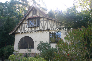 Eltham District Historical Society Inc
Photograph - Digital Photograph, Alan King, The Robins, 13 Kangaroo Ground-Warrandyte Road, North Warrandyte, 2 March 2008
... landscape in 1914. In 1915 Boyd joined the Australian Imperial Force, and became a sergeant in the Electrical and Mechanical Mining Company. ...landscape in 1914. In 1915 Boyd joined the Australian Imperial Force, and became a sergeant in the Electrical and Mechanical Mining Company. ...Built by noted artist Theodore Penleigh Boyd, father of architect Robin Boyd. Covered under National Estate, National Trust of Australia (Victoria) Local Significance and Heritage Overlay, Nillumbik Planning Scheme. Published: Nillumbik Now and Then / Marguerite Marshall 2008; photographs Alan King with Marguerite Marshall.; p111 The Robins at Warrandyte,* was once home to a member of a famous family and is also one of the first reinforced concrete houses in Victoria. The builder, Theodore Penleigh Boyd, born in 1890, was a talented painter1 noted for his works of the Warrandyte bush. He was the father of architect Robin Boyd, author of the Australian Ugliness and the uncle of painter, Arthur Boyd. Penleigh Boyd’s great grandfather was Sir William A’Beckett, Victoria’s first Chief Justice. Penleigh Boyd is considered by some to be an ‘unsung hero’ overshadowed by more famous members of his family. Mornington Gallery Director Andrea May said many believed Boyd ‘had never received the national acclaim that he deserved’.2 Classified by the National Trust3 and part of the Australian National Heritage,4 The Robins is set well back near the end of Kangaroo Ground – Warrandyte Road, unobserved by passers-by. Built in 1913, The Robins has some Art Nouveau influences and is a descendant of the Queen Anne style. It is covered in stucco and has a prominent attic, which Boyd used as a studio. Some parts of the house are up to 33 centimetres thick and built in part with pisé (rammed earth) and in part with reinforced concrete. Amazingly, Boyd built The Robins without an accessible driveway, and only a narrow track along which he had to cart building materials. The journey was uphill and Boyd terraced the land with Warrandyte rock5 without the aid of machinery. At only 33 years, Boyd was killed in a car accident in 1923. He was buried in Brighton near the home of his parents. Several people have since owned the house, including political journalist, Owen Webster. Boyd was born at Penleigh House, Wiltshire, and studied at Haileybury College, Melbourne and The Hutchins School, Hobart. He attended the Melbourne National Gallery School and in his final year exhibited at the Victorian Artists’ Society. He arrived in London in 1911 and his painting Springtime was hung at the Royal Academy. He painted in several studios in England and then worked in Paris.6 There he met painter Phillips Fox through whom he met artists of the French modern school and also his wife-to-be, Edith Anderson, whom he married in Paris in 1912. After touring France and Italy, the couple returned to Melbourne. In 1913 Boyd held an exhibition and won second prize in the Federal Capital site competition, then the Wynne Prize for landscape in 1914. In 1915 Boyd joined the Australian Imperial Force, and became a sergeant in the Electrical and Mechanical Mining Company. However he was severely gassed at Ypres and invalided to England. In 1918 in London Boyd published Salvage, writing the text and illustrating it with 20 black-and-white ink-sketches of army scenes. Later that year he returned to Melbourne, and, despite suffering from the effects of gas, he held several successful one-man shows, quickly selling his water-colour and oil paintings. In his short career Penleigh Boyd was recognized as one of Australia’s finest landscape painters. He loved colour, having been influenced early by Turner and McCubbin. His works are in all Australian state galleries, the National Collection in Canberra as well as in regional galleries.7 His wife Edith was also an artist having studied at the Slade School, London, and in Paris with Phillips Fox. After her marriage she continued to paint and excelled in drawing. In later years she wrote several dramas, staged by repertory companies, and radio plays for the Australian Broadcasting Commission, in which she took part. She was the model for the beautiful red-haired woman in several of Phillips Fox’s paintings and the family hold three of his portraits of her. *Possibly named after the Aboriginal words warran, meaning ‘object’ and dyte, meaning ‘thrown at’.This collection of almost 130 photos about places and people within the Shire of Nillumbik, an urban and rural municipality in Melbourne's north, contributes to an understanding of the history of the Shire. Published in 2008 immediately prior to the Black Saturday bushfires of February 7, 2009, it documents sites that were impacted, and in some cases destroyed by the fires. It includes photographs taken especially for the publication, creating a unique time capsule representing the Shire in the early 21st century. It remains the most recent comprehenesive publication devoted to the Shire's history connecting local residents to the past. nillumbik now and then (marshall-king) collection, kangaroo ground-warrandyte road, north warrandyte, the robins -
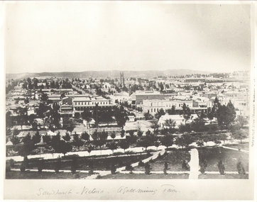 Bendigo Historical Society Inc.
Photograph - SANDHURST - VICTORIA, A GOLD MINING TOWN, Earliest c 1885
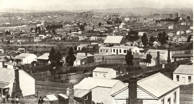
... History House 11 Mackenzie Street Bendigo goldfields PLACE Landscape view sandhurst from rosalind park B+W Photograph. Copy of 'Sandhurst - Victoria a Gold-Mining Town'. ...B+W Photograph. Copy of 'Sandhurst - Victoria a Gold-Mining Town'. View from Rosalind Park. Notable BLDOR Shamrock Hotel, St Pauls Church, railway station. Inscription: on RH 'Extract from cement -???'. Photograph shows early Sandhurst with Chimney of Goldmine of R.H.S(R.S.L now occupies this site).place, landscape view, sandhurst from rosalind park -
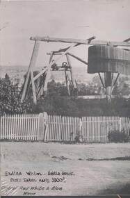 Bendigo Historical Society Inc.
Photograph - CENTRAL RED WHITE AND BLUE MINE, c1900s early
... Landscape view in background most likely High Street Bendigo/Golden Square boundary. Markings/Inscriptions: Central Red White and Blue Mine, Corner Lilac and Honeysuckle Sts. Fadies Whim, Nettle Street, Photo Taken early 1900s. Central Red White & Blue Whim. On rear of photo: Evolution in mining...mining Lilac Honeysuckle Fadies Whim 1900s poppet head Black and White photo. On the right is the Central Red White and Blue Mine at the corner of Lilac and Honeysuckle Sts, at the front of the photo is Fadies Whim in Nettle Street, Iron Bark. Landscape ...Black and White photo. On the right is the Central Red White and Blue Mine at the corner of Lilac and Honeysuckle Sts, at the front of the photo is Fadies Whim in Nettle Street, Iron Bark. Landscape view in background most likely High Street Bendigo/Golden Square boundary. Markings/Inscriptions: Central Red White and Blue Mine, Corner Lilac and Honeysuckle Sts. Fadies Whim, Nettle Street, Photo Taken early 1900s. Central Red White & Blue Whim. On rear of photo: Evolution in mining apparatus is illustrated in this photograph - Bendigo. 2 Royal Historical Society of Victoria, Bendigo Branch stamps on rear also.central red white and blue mine, mining, lilac, honeysuckle, fadies whim, 1900s, poppet head -
 Bendigo Historical Society Inc.
Photograph - NEW CHUM GULLY C 1875, C 1875
... Landscape view...new chum gully...Bendigo... cityscape... Sandhurst... panorama... mining...History House 11 Mackenzie Street Bendigo goldfields PLACE Landscape view new chum gully Bendigo cityscape Sandhurst panorama mining town Caire Back and white photograph: panorama showing timber and brick residences, hotel, church ? ...Back and white photograph: panorama showing timber and brick residences, hotel, church ? Mines with poppet heads and chimneys in background. An image on building at centre ' Cleary's Honeysuckle Hotel' Ken Arnold captions this image ' New Chum Gully from Specimen Hill C 1875, photographer Caire 'Caireplace, landscape view, new chum gully, bendigo, cityscape, sandhurst, panorama, mining town -
 Bendigo Historical Society Inc.
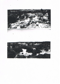
Newspaper - LONG GULLY HISTORY GROUP COLLECTION: LANDSCAPE PHOTOS
... The Long Gully History Group - Landscape Photos... Mining...Two pages of photocopies of photos, four of landscape photos and one of what looks like drums in a bunker. Two of the photos are scenes of mining areas, one has bush, buildings and poppet legs and one is a view of the town area taken from a lookout. ...History House 11 Mackenzie Street Bendigo goldfields BENDIGO History long gully history group The Long Gully History Group - Landscape Photos Mining Areas Two pages of photocopies of photos, four of landscape photos and one of what looks like drums in a bunker. ...Two pages of photocopies of photos, four of landscape photos and one of what looks like drums in a bunker. Two of the photos are scenes of mining areas, one has bush, buildings and poppet legs and one is a view of the town area taken from a lookout. There are two people leaning on the fence.bendigo, history, long gully history group, the long gully history group - landscape photos, mining areas -
 Bendigo Historical Society Inc.
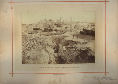
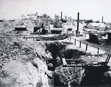
Photograph - VICTORIA HILL, 1860's ?
... History House 11 Mackenzie Street Bendigo goldfields PLACE Landscape view victoria hill Black and white photo - mines and mining. At centre front - deep trench. ...Black and white photo - mines and mining. At centre front - deep trench. At centre shed, poppet legs, wood pile, building with chimney at right. Wood pile, Building with chimney at back. At back, poppet legs on horizon, trees, building ( house ) buildings with chimney, trees, behind trees large 2 storey building ( Gold Mines Hotel ? ) other large buildings on horizon to right. ' Mining - Bendigo Vic. View of Victoria Hill taken from Old Chum Hill' written on back of photo.place, landscape view, victoria hill