
Showing 8 items matching " mulgrave road"
-
 Glen Eira Historical Society
Map - CAPLES PLACE SUBDIVISION
... ... Mulgrave Road...Land Subdivisions Documents Maps Glen Eira CAPLES PLACE CAPLES PLACE Subdivision Land Surveys Orrong Road Mulgrave Road Prahran Grove Somerset Road Prahran Grove Prahran Grove East Walk Land Allotments Town Planning Garden Road Map CAPLES PLACE SUBDIVISION ...This file contains a copy of a map of the CAPLES PLACE SUBDIVISION, undated and author unknown. The map provides the dimensions of roads and allotments in the area, including also handwritten notes from the original document and others written directly onto the copy.land subdivisions, documents, maps, glen eira, caples place, caples place subdivision, land surveys, orrong road, mulgrave road, prahran grove, somerset road, prahran grove, prahran grove, east walk, land allotments, town planning, garden road -
 Warrnambool and District Historical Society Inc.
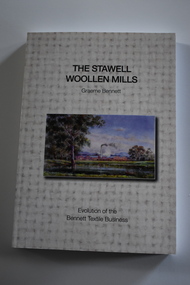
Book, The Stawell Woollen Mill, 2013
... 5 Dunlop Road, Mulgrave, Victoria, Australia. ...This book, written by Graeme Bennett, gives information on the Bennett family history and the history of the Stawell Woollen Mills. The Bennett family was associated with the textile industry for more than 200 years. The book gives information on John Edward Bennett (1862-1928) who, in 1909 became the first manager of the Warrnambool Woollen Mill. This mill opened in 1910 and closed in 2000 and was a dominant business, known throughout Australia for its woollen blankets. John Bennett was a highly-successful manager at the Warrnambool Woollen Mill from 1909 until his death in 1928. His son, who was the assistant manager at the mill, left in 1926 to take over the Stawell Woollen Mill.This book is of considerable interest as it contains valuable information on the author’s grandfather, John Edward Bennett, important in Warrnambool’s history as the first manager of the Warrnambool Woollen Mill, a prominent business in Warrnambool for 90 years.This is a soft cover book of 384 pages. The front cover has a mottled cream and black background with black lettering and a colour photograph of a painting of the Stawell Woollen Mill. The back cover and spine have the same mottled pattern with black lettering. The book has 22 chapters and several colour and black and white photographs. john e bennett, warrnambool woollen mill, stawell woollen mill -
 Ringwood and District Historical Society
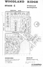
Flyer - Land Sale, Preplanned Development - Woodland Ridge Estate Stages 1, 2 and 3, Ringwood North, Vic. - circa 1972
... Jennings Industries (Aust) Ltd., 690 Springvale Road, Mulgrave, 3170. Phone 560 8411. ...Jennings Industries (Aust) Ltd., 690 Springvale Road, Mulgrave, 3170. Phone 560 8411. Preplanned Development - Woodland Ridge Estate Stages 1, 2 and 3, Ringwood North, Vic. - circa 1972. ...Subdivison maps of Woodland Ridge Estate. Stage 1 includes Berringa Road, Oban Road, Athelstane Drive, Braimton Close, Karima Court, Tania Place, Runyan Court. Stage 2 includes Athelstane Drive, Cormiston Road, Linda Place, Casula Place, Oban Road. State 3 includes Williams Road, Athelstane Drive, Tania Place and Cormiston Road. Developer - A.V. Jennings Industries (Aust) Ltd., 690 Springvale Road, Mulgrave, 3170. Phone 560 8411. Supplementary page with early 2000s sale prices for eight addresses - 16 Athelstane Drive Ringwood 3134 $210,000 4/4/2000 19 Athelstane Drive Ringwood 3134 $235,000 14/1/2000 27 Cormiston Road Ringwood 3134 $246,000 28/10/2000 1 Runyan Court Ringwood 3134 $183,000 2/5/2001 4 Runyan Court Ringwood 3134 $179,000 14/8/2000 11 Runyan Court Ringwood 3134 $193,000 28/4/2000 7 Runyan Court Ringwood 3134 $187,500 14/1/2000 4 Casula Place Ringwood 3134 $216,000 13/2/2001 Accompanying handwritten notation by Richard Carter R.E.S.I. - "Purchaser of 'Pre-planned Development' lots also agreed to purchase the house planned for the lot. Bramton Court "Witheld" for display homes. Stage 3 one acre sites drained north therefore not readily sewered." -
 Ringwood and District Historical Society
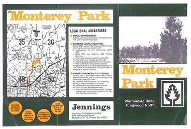
Document - Folder, Land Sale - Monterey Park Subdivision, Warrandyte Road, Ringwood North, Vic. - 1981
... Vendor - Jennings Industries Limited, 690 Springvale Road, Mulgrave, 3170, Phone 5618000. A4 enclosures with tables showing each allotment List Price, Builders Price, Cash Price and Terms Price. ...Vendor - Jennings Industries Limited, 690 Springvale Road, Mulgrave, 3170, Phone 5618000. A4 enclosures with tables showing each allotment List Price, Builders Price, Cash Price and Terms Price. ...Foolscap manilla folder containing double-sided flyer advertising residential subdivision development, including outline of local facilities and services, with locality map and layout of Monterey Park streets. Subdivision includes Parkwood High School, Tortice Drive, Heape Way, Appleberry Place, Stringybark Court, Conifer Court, Crawley Grove, Monterey Close (later Monterey Place), Lucy Place, Middlebrook Drive, Gahnia Close, Glanfield Court, Cone Close, Jull Parade, Pinus Close (later Pinetree Court), Radiata Close, Old Warrandyte Road, and entry from Warrandyte Road. Vendor - Jennings Industries Limited, 690 Springvale Road, Mulgrave, 3170, Phone 5618000. A4 enclosures with tables showing each allotment List Price, Builders Price, Cash Price and Terms Price. Information page headed "Form of Restrictive Covenant to be incorporated in Transfer" specific to Certificates of Title. Restrictive Covenant (summary): (Name/s) "... will not erect or construct or cause to be erected or constructed on the land hereby transferred (a) Any front boundary fence, other than a fence which does not exceed one metre in height unless the same is set back as least 1.5 metres from the front boundary and the same is effectively screened from that boundary by the planting of trees, shrubs or plants. (b) Any side boundary fence other than a fence which is set back at least 1.5 metres from the front boundary on which does not exceed 1 metre in height within 1.5 metres of the front boundary. (c) For a period of 5 years from the date hereof, any building on the said land unless and until the Plans and Specifications thereof have first been approved by the said Residential Developments Pty. Limited. (d) For a period of 2 years from the date hereof whilst the said land remains vacant any Signboard or Notice advertising the sale of the said lot or any other lot. These covenants shall appear on the Certificate of Title to issue for the said land and run with the land." -
 Ringwood and District Historical Society
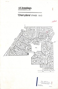
Flyer, Land Sale Advertisement - Cherrydene Estate, Stage 1 & 2, Ringwood, Vic. - 1969
... Mulgrave, Vic. Phone 560 8411. Sales Dept. Rep., Leon B. Devine, Phone 560 8411 A/H.435 5311. Subdivision includes Wonga Road, Holyrood Crescent, Clipper Court, Ripley Court, Harwick Close, Bader Court, Towerhill Drive, Nigel Court, Berkley Road, Avis Court, Carmen Close, Frederic Drive, Kenwood Crescent, Adele Court, Marilyn Street, Abbey Court, Baron Court, Kismet Close, Oban Road, Ringwood....Mulgrave, Vic. Phone 560 8411. Sales Dept. Rep., Leon B. Devine, Phone 560 8411 A/H.435 5311. Subdivision includes Wonga Road, Holyrood Crescent, Clipper Court, Ripley Court, Harwick Close, Bader Court, Towerhill Drive, Nigel Court, Berkley Road, Avis Court, Carmen Close, Frederic Drive, Kenwood Crescent, Adele Court, Marilyn Street, Abbey Court, Baron Court, Kismet Close, Oban Road, Ringwood. ...Subdivison map of Cherrydene Estate and double-sided A4 size House & Land price list dated 27/10/1969. Developer - A.V. Jennings Industries (Aust) Ltd., Cnr. Springvale & Wellington Rds., Mulgrave, Vic. Phone 560 8411. Sales Dept. Rep., Leon B. Devine, Phone 560 8411 A/H.435 5311. Subdivision includes Wonga Road, Holyrood Crescent, Clipper Court, Ripley Court, Harwick Close, Bader Court, Towerhill Drive, Nigel Court, Berkley Road, Avis Court, Carmen Close, Frederic Drive, Kenwood Crescent, Adele Court, Marilyn Street, Abbey Court, Baron Court, Kismet Close, Oban Road, Ringwood.Furnished and landscaped display homes are open for your inspection, (see map on reverse side) from 11 a.m. to 5 p.m. Sundays and Holidays, and 2 p.m. to 5 p.m. weekdays and Saturdays. Display homes list for 'Cherrydene' Ringwood - Arundel, Ashmoor, Avalon, Cleveland, Chiltern, Dorset. -
 Ringwood and District Historical Society
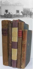
Book - Business Records, Collection of 5 Day-books and Ledgers kept by Thomas Grant, Blacksmith, Ringwood, Victoria
... Gostick in Whitehorse Road, in the vicinity of the present Drive In Arcade, he built a blacksmith's and coach building shop. In 1880, he married Mary Ann French, of Mulgrave. ...Gostick in Whitehorse Road, in the vicinity of the present Drive In Arcade, he built a blacksmith's and coach building shop. In 1880, he married Mary Ann French, of Mulgrave. ...GRANT, Thomas (From Short Notes on Ringwood - RDHS) Born 1854, died 1933, aged 79 years. Thomas Grant, born in Burwood, Victoria, came to Ringwood in 1876. On land purchased from Mr. D. Gostick in Whitehorse Road, in the vicinity of the present Drive In Arcade, he built a blacksmith's and coach building shop. In 1880, he married Mary Ann French, of Mulgrave. There were four children, Andrew, Mary, (died in infancy) Thomas, and Margaret. Miss Margaret Grant is a well known resident of Mullum Road. With the opening of the station in 1882, activities in the growing district tended to congregate in its vicinity, and, in 1883, Mr. Grant moved his “smith" to the corner of Adelaide Street. At the same time, he planted out an orchard on his land which ran from Ringwood Street, to Warrandyte Road, and north as far as Mullum Greek. Eventually, about 1910, he sold his business to the Reed Brothers, and retired to the comparatively lighter life of orchardist and market gardener. In 1909, he sold 8 acres of his land to the Lilydale Council. This land, situated in Ringwood Street, behind the Town Hall, is known as the Ringwood Reserve. Mr. & Mrs. Grant were foundation members of the Methodist Church. He was appointed a Trustee in 1879, and served until his death 54 years later. He was an enthusiastic member of many societies, and he held public office in civic affairs. His interests included the Progress Association, Cricket Club, and the Agricultural Society, at whose annual show, he was a regular exhibitor. He served as a Councillor in the Lilydale Shire, repres¬enting Ringwood, from 1889 to 1894, and was a Justice of the Peace. 26278a Ledger belonging to First Blacksmith in Ringwood 1880s. Dark green cover with leather spine and corners. Dark coloured edges on pages. 542 pages, 320 used. 26278b Day book belonging to Thomas Grant, Blacksmith, Ringwood used 1929. Brown covered book with leather spine. First 95 pages torn out. Only two pages of remaining 76 used. 26278c Ledger with alphabetical index - Thomas Grant, Blacksmith, Ringwood - 1888. Green covered book with red spine and corners. Dark coloured edges on pages. 275 pages. Some unused. 26278d T. Grant Blacksmith Day Book. Green covered day book of T. Grant, Blacksmith and General Smithy, Ringwood 1883 . Red square on spine with Day book written on it. Day Book in ink hand written on front spine. 26278e Day book belonging to Thomas Grant, Blacksmith, Ringwood - 1879-1881. Green cover with brown spine and edges. Gold lettering on spine saying Day Book Pages all used. 26278f Collection of receipts, some blotting paper, some pages from the Journal of Architecture, a short story, and drawing with description of an Albert Sociable carriage. -
 Bayside Gallery - Bayside City Council Art & Heritage Collection
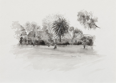
Work on paper - ink and watercolour, Annette Meikle, Semco Park, 1977
... Semco Park was sold to developers in 1977 but the business continued until the early 1990s with the office moving to Mulgrave, while factory work shifted to New Zealand. annette meikle sandringham sketchbook elizabeth waters Semco Park Semco Cheltenham Road Black Rock Semco Park Work on paper ink and watercolour Annette Meikle ...In 1977, artist Annette Meikle undertook a commission to illustrate a book recording stories of places and people in the Bayside area. It was published in 1978 as Sandringham Sketchbook, with text by Elizabeth Waters. The sketches were intended to record remaining examples of Bayside’s early architecture and environment, as well as reflect newer architectural changes. Meikle went on to donate 22 of these sketches to Bayside City Council in 2003. Semco Park was a model of exemplary modern business in the 1920s. Located on Cheltenham Road, Black Rock, then considered to be an outer suburb, the property was home to Semco, a manufacturing and importing business of paper goods and cotton fabric items. The business’s governing director, Charles Mylius, wanted a firm that treated staff with fairness, created healthy and spacious working sites and offered recreational facilities. The site contained a factory as well as three houses for staff, a park with lawns, trees and flowerbeds, a cricket oval and a canteen serving hot food. Staff enjoyed soft background music played in the factory, and benefited from a superannuation scheme. Semco Park was sold to developers in 1977 but the business continued until the early 1990s with the office moving to Mulgrave, while factory work shifted to New Zealand.Annette Meikle, Semco Park 1977, ink and watercolour, 25.8 x 35.7 cm. Bayside City Council Art and Heritage Collection. Donated by the artist, 2003annette meikle, sandringham sketchbook, elizabeth waters, semco park, semco, cheltenham road, black rock -
 Whitehorse Historical Society Inc.
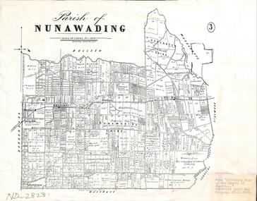
Map - Parish Map, Parish of Nunawading, 1892
... The area boundaries include the Koonung Creek between Elgar Road and Springvale Road to the south, Mullum Mullum Creek and Dandenong Creek to the east and Boundary Road, Mulgrave to the north. Maps Parish of Nunawading A map copied from 'Directory maps - parishes and counties' dated 26 Nov 1892. ...A map copied from 'Directory maps - parishes and counties' dated 26 Nov 1892. Compiled and lithographed by G.S. Bonney. The map includes roads, railway, stations, names of property owners. It has a scale [ca. 1:31,680] 40 chains to an 1 inch.A map copied from 'Directory maps - parishes and counties' dated 26 Nov 1892. Compiled and lithographed by G.S. Bonney. The map includes roads, railway, stations, names of property owners. It has a scale [ca. 1:31,680] 40 chains to an 1 inch.non-fictionA map copied from 'Directory maps - parishes and counties' dated 26 Nov 1892. Compiled and lithographed by G.S. Bonney. The map includes roads, railway, stations, names of property owners. It has a scale [ca. 1:31,680] 40 chains to an 1 inch.maps, parish of nunawading
