Showing 76 items matching " neilborough"
-
 Bendigo Historical Society Inc.
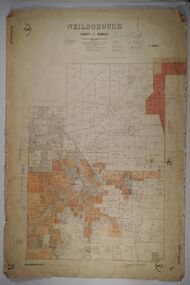
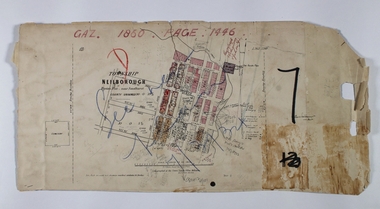
Map - NEILBOROUGH, 27/09/1904
... NEILBOROUGH......Neilborough...Map: Neilborough, County of Bendigo. Parish plan...History House 11 Mackenzie Street Bendigo goldfields MAP Bendigo parish plan Neilborough Map: Neilborough, County of Bendigo. ...Map: Neilborough, County of Bendigo. Parish planmap, bendigo, parish plan, neilborough -
 Bendigo Historical Society Inc.
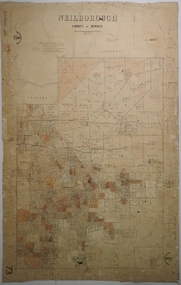
Map - NEILBOROUGH, 15/10/1877
... NEILBOROUGH......Neilborough...Map: Neilborough, County of Bendigo. Parish plan (number 301 in map cupboard 1)...History House 11 Mackenzie Street Bendigo goldfields MAP Bendigo parish plan Neilborough Elysian Flat Map: Neilborough, County of Bendigo. ...Map: Neilborough, County of Bendigo. Parish plan (number 301 in map cupboard 1)map, bendigo, parish plan, neilborough, elysian flat -
 Bendigo Historical Society Inc.
Map - NEILBOROUGH, 21/01/1875
... NEILBOROUGH......Neilborough...Map: Parish of Neilborough, County of Bendigo. Hand draughted Parish plan. ...History House 11 Mackenzie Street Bendigo goldfields MAP Bendigo parish plan Neilborough G. Black W.A. Taylor Map: Parish of Neilborough, County of Bendigo. ...Map: Parish of Neilborough, County of Bendigo. Hand draughted Parish plan. Resurveyed by Mr Assistant-Surveyor G Black. Drawn by W A Taylor. Map dated 21/1/1875.map, bendigo, parish plan, neilborough, g. black, w.a. taylor -
 Bendigo Historical Society Inc.
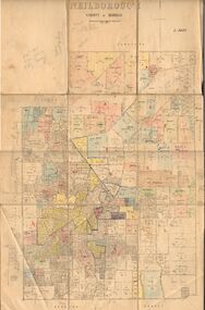
Map - NEILBOROUGH, 6/12/1882
... NEILBOROUGH......Neilborough...Map: Parish of Neilborough, County of Bendigo. Parish plan. J A Morrison Junior June 1877. ...History House 11 Mackenzie Street Bendigo goldfields MAP Bendigo parish plan Neilborough J A Morrison Jr. Harvey J V Walshe Map: Parish of Neilborough, County of Bendigo. ...Map: Parish of Neilborough, County of Bendigo. Parish plan. J A Morrison Junior June 1877. Examined by ? Harvey 21/8/1877. Additions made by J V Walshe24/10/82. Examined by E D 39/10/82.map, bendigo, parish plan, neilborough, j a morrison jr., harvey, j v walshe -
 Bendigo Historical Society Inc.
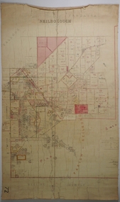
Map - JACK FLYNN COLLECTION: NEILBOROUGH, 13/10/1927
... ...Neilborough...Map: Parish of Neilborough, County of Bendigo. Parish plan....Butson Map: Parish of Neilborough, County of Bendigo. Parish plan. Map JACK FLYNN COLLECTION: NEILBOROUGH ...Map: Parish of Neilborough, County of Bendigo. Parish plan.Photo Lithographed at the Department of Lands and Survey, Melbourne by W.J. Butsonmap, bendigo, parish plan, neilborough -
 Bendigo Historical Society Inc.
Map - NEILBOROUGH RAVENSWOOD, October 21 1859
... ...Neilborough...Map:Township of Neilborough, Elysian Flat, near Sandhurst,County unnamed. ...History House 11 Mackenzie Street Bendigo goldfields MAP Bendigo Neilborough Elysian Flat Ravenswood Map:Township of Neilborough, Elysian Flat, near Sandhurst,County unnamed. ...Map:Township of Neilborough, Elysian Flat, near Sandhurst,County unnamed. Parish plan. Backing is a part of Ravenswood Township map.map, bendigo, neilborough, elysian flat, ravenswood -
Bendigo Historical Society Inc.
Map - NEILBOROUGH : COUNTY OF BENDIGO, 13-10-27
... ...neilborough...Map. Neilborough, County of Bendigo, Tandarra, Whirrakee, Huntly, Nerring, Yarraberb, Yallook, Photo-Lithographed at the Department of Lands and Survey, Melbourne by W.J. ...History House 11 Mackenzie Street Bendigo goldfields MAP Bendigo neilborough W.J. Butson. Map. Neilborough, County of Bendigo, Tandarra, Whirrakee, Huntly, Nerring, Yarraberb, Yallook, Photo-Lithographed at the Department of Lands and Survey, Melbourne by W.J. ...Map. Neilborough, County of Bendigo, Tandarra, Whirrakee, Huntly, Nerring, Yarraberb, Yallook, Photo-Lithographed at the Department of Lands and Survey, Melbourne by W.J. Butson 13-10-27, Price 1/- (number 77 in map cupboard 1)W.J. Butson.map, bendigo, neilborough -
Bendigo Historical Society Inc.
Film - Eucalyptus Oil Production in the Whipstick, 1979-1980
... ...neilborough...The Distillery at Neilborough was owned and operated by brothers Percy and Ron Hooper of Raywood (both now deceased). ...History House 11 Mackenzie Street Bendigo goldfields The Distillery at Neilborough was owned and operated by brothers Percy and Ron Hooper of Raywood (both now deceased). ...The Distillery at Neilborough was owned and operated by brothers Percy and Ron Hooper of Raywood (both now deceased). They allowed students from the Whipstick Environment Centre to visit.Eucalyptus Oil Production in the Whipstick - a slideshow compiled from 52 slides and an audio file - produced by John Lindrer, Bendigo, Departmentment of Special Services, Education Department. The slides and audio were used at schools around Bendigo from 1980 to 1992; also at the Whipstick Environment Centre. The slideshow depicts the methodology of eucalyptus harvesting and oil extraction which is now superceded. history, bendigo, whipstick, whipstick environment centre, ray hooper, percy hooper, neilborough, raywood, eucalyptus, eucalyptus oil, eucalyptus distillery -
Bendigo Historical Society Inc.
Map - RAYWOOD GOLD FIELD MAP, 1902
... ... Neilborough...Linen backed map of Raywood and Neilborough Township and surrounds showing the location of varying underground workings. ...MAP gold field map Raywood Gold Field Map Neilborough H S Whitelaw Geological Survey of Victoria Bulletin No 12 Plate 11 Map. ...Map. Raywood Gold Field Map. Linen backed map of Raywood and Neilborough Township and surrounds showing the location of varying underground workings. Surveyed by H S Whitelaw 1/6/02. It shows underground workings from The Perseverance Party and moreshed and Party and underground workings on the Old Pioneer Reef. Mentions the Parish of Yallook, Parish of Neilborough, Yarraberb, Mushroom Flat, Murray Valley Plain, Eaglehawk and Kerang Railway, Green Hill, Doughboy, Redmond's Gully, Pickpocket Lead, Raywood Lead, Inglewood Lead, Shaw's Road, Nuggety Shaft, Barkly Shaft, Maori Bendmap, gold field map, raywood gold field map, neilborough, h s whitelaw, geological survey of victoria bulletin no 12 plate 11 -
Bendigo Historical Society Inc.
Map - CAMPBELL COLLECTION: BENDIGO & DISTRICT MAPS
... Map. copy. Raywood, Neilborough, Sebastian, Yarraberb, Woodvale. ...History House 11 Mackenzie Street Bendigo goldfields MAP Bendigo country lands Map. copy. Raywood, Neilborough, Sebastian, Yarraberb, Woodvale. (number 372 in map cupboard 1) Map CAMPBELL COLLECTION: BENDIGO & DISTRICT MAPS. ...Map. copy. Raywood, Neilborough, Sebastian, Yarraberb, Woodvale. (number 372 in map cupboard 1)map, bendigo, country lands -
Bendigo Historical Society Inc.
Map - RAYWOOD, 18/09/1930
... Map: Township of Raywood, Parish of Neilborough,County of Bendigo. Parish plan (number 270 in map cupboard 1)...History House 11 Mackenzie Street Bendigo goldfields MAP Bendigo township Raywood Map: Township of Raywood, Parish of Neilborough,County of Bendigo. Parish plan (number 270 in map cupboard 1) Map RAYWOOD ...Map: Township of Raywood, Parish of Neilborough,County of Bendigo. Parish plan (number 270 in map cupboard 1)map, bendigo, township, raywood -
Bendigo Historical Society Inc.
Map - KAMAROOKA STATE FOREST, 23/11/1910
... Map: Part of Subdivision of kamarooka State Forest, Parishes of Neilborough and Whirrakee, County of Bendigo. ...History House 11 Mackenzie Street Bendigo goldfields MAP Bendigo subdivision Kamarooka State Forest Subdivision Whirrakee Map: Part of Subdivision of kamarooka State Forest, Parishes of Neilborough and Whirrakee, County of Bendigo. ...Map: Part of Subdivision of kamarooka State Forest, Parishes of Neilborough and Whirrakee, County of Bendigo. Parish plan (number 287 in map cupboard 1)map, bendigo, subdivision, kamarooka state forest, subdivision, whirrakee -
 Bendigo Historical Society Inc.
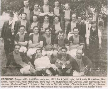
Newspaper - JENNY FOLEY COLLECTION: PREMIERS
... In 1949, Kamarooka, Neilborough and Raywood combined to form Northern United Football club....In 1949, Kamarooka, Neilborough and Raywood combined to form Northern United Football club. ...Raywood played their first football match against Inglewood 30/1/1904. In 1949, Kamarooka, Neilborough and Raywood combined to form Northern United Football club.Bendigo Advertiser ''The way we were'' from 2003. Premiers: Raywood football club members, 1922. Back left to right: Mick Kelly, Roc Wilson, Nev Smith, Harry Rick, Keith McKenzie. Third row: ?? Hutchinson, bill Clohsey, Jack Gaywood, Perc Johnson, Grahem O'Neil, B. Johnson. Second row: Syd Moorshead, Charlie Jackson, Edgar Johnson, Andy Scott, Dan Clohsey. Front: Ray Moorshed, Dip Hall (umpire), Eddie Pierce, Nipper Eeles. The clip is in a folder.newspaper, bendigo advertiser, the way we were -
 Bendigo Historical Society Inc.
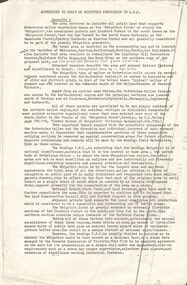
Document - PETER ELLIS COLLECTION: DRAFT OF WHIPSTICK SUBMISSION
... Locations are in the Parishes of Whirrakee, Egerton, Neilborough, Nerring, Huntly and Eaglehawk. Soil types are mentioned and also the Whipstick Scrub area. ...Locations are in the Parishes of Whirrakee, Egerton, Neilborough, Nerring, Huntly and Eaglehawk. Soil types are mentioned and also the Whipstick Scrub area. ...Appendices to Draft of Whipstick Submission to LCC, Appendix 1. Locations are in the Parishes of Whirrakee, Egerton, Neilborough, Nerring, Huntly and Eaglehawk. Soil types are mentioned and also the Whipstick Scrub area. Type of park is mentioned.bendigo, national parks, peter ellis collection, kamarooka forest, egerton forest, lightning hill recreation reserve, eaglehawk rifle range, new moon mines, d j paton, bendigo field naturalists club, land conservation council, eucalyptus oil production -
Bendigo Historical Society Inc.
Map - NERRING : COUNTY OF BENDIGO, August 1952
... Nerring, County of Bendigo, Leichardt, Marong, Sandhurst, Huntly, Neilborough, Yarraberb. Drawn and Reproduced at the Department of Lands and Survey, Melbourne, Victoria, August 1952, Price 2/-.( number 409 in Map Cupboard 1)....Nerring, County of Bendigo, Leichardt, Marong, Sandhurst, Huntly, Neilborough, Yarraberb. Drawn and Reproduced at the Department of Lands and Survey, Melbourne, Victoria, August 1952, Price 2/-.( number 409 in Map Cupboard 1). ...Map. Nerring, County of Bendigo, Leichardt, Marong, Sandhurst, Huntly, Neilborough, Yarraberb. Drawn and Reproduced at the Department of Lands and Survey, Melbourne, Victoria, August 1952, Price 2/-.( number 409 in Map Cupboard 1).J.J. Gourley, Government Printer, Melbourne.bendigo, hospital -
 Bendigo Historical Society Inc.
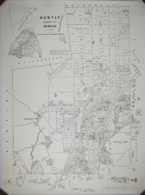
Map - CAMPBELL COLLECTION: BENDIGO AND DISTRICT MAPS, 1959
... Huntly, County of Bendigo, Neilborough, Bagshot, Nerring, Wellsford, Sandhurst. ...Huntly, County of Bendigo, Neilborough, Bagshot, Nerring, Wellsford, Sandhurst. ...Map. Huntly, County of Bendigo, Neilborough, Bagshot, Nerring, Wellsford, Sandhurst. Township of Huntly. By Authority A.C. Brooks, Government Printer Melbourne. Drawn and reproduced at the Department of Lands and Survey, Melbourne, 1958. Price 5/-.A.C. Brooks, Government Printermap, bendigo, allotments, huntly -
Bendigo Historical Society Inc.
Map - CAMPBELL COLLECTION: BENDIGO AND DISTRICT MAPS, 11-4-29
... Huntly, Parishes of Huntly, Nerring and Neilborough. Scale 20 chains to 1 inch. Total area 4738 acres. ...Huntly, Parishes of Huntly, Nerring and Neilborough. Scale 20 chains to 1 inch. Total area 4738 acres. ...Map. Huntly, Parishes of Huntly, Nerring and Neilborough. Scale 20 chains to 1 inch. Total area 4738 acres. Prepared in W.P.B. from A and C.L. Plans by W.J. Galbraith 11-4-29. Eaglehawk. IN PENCIL top right of map: Euc areas 1974 Scott & Cole Comp 5,6,7,8,9,12,13. Laurie C.Raynor 10,11,17, Part 16 South of Scotsmans Track, J.T Pierce 14,15,16 North of Scotsman Track. From Neilborough. G.Ward. A.Sloan. K.Walker at bottom of map. (number 368 in map cupboard 1)W.J.Galbraithmap, bendigo, allotments -
 Bendigo Historical Society Inc.
Book - LIGHTNING HILL MINE SITE HUSTLERS LIGHTNING HILL EAGLEHAWK TO IRON'S DAM NEILBOROUGH, 1992
... Book 3, Site 10.1, Lightning Hill Mine Site, Hustler's/Lightning Hill, Eaglehawk to site 14.4, Iron's Dam, Neilborough. Contains significance reports prepared for North Central Goldfields Project: Bendigo Goldfield....Book LIGHTNING HILL MINE SITE HUSTLERS LIGHTNING HILL EAGLEHAWK TO IRON'S DAM NEILBOROUGH ...Book 3, Site 10.1, Lightning Hill Mine Site, Hustler's/Lightning Hill, Eaglehawk to site 14.4, Iron's Dam, Neilborough. Contains significance reports prepared for North Central Goldfields Project: Bendigo Goldfield.David Bannearbendigo, mining, goldfields reports, bendigo, gold, goldfields, history, reports -
Bendigo Historical Society Inc.
Map - YALLOOK : COUNTY OF BENDIGO, 1957
... Yallook, County of Bendigo,Talambe, Tandarra, Neilborough, Yarraberb, Salisbury, Pompapiel. ...Yallook, County of Bendigo,Talambe, Tandarra, Neilborough, Yarraberb, Salisbury, Pompapiel. ...Map. Yallook, County of Bendigo,Talambe, Tandarra, Neilborough, Yarraberb, Salisbury, Pompapiel. Drawn and reproduced at the Department of Lands and Survey, Melbourne.1957. Price 2/-. By authority W.M. Houston, Government Printer. (number 11 in map cupboard 1)W.M Houston, Government Printermap, bendigo, yallook -
Bendigo Historical Society Inc.
Map - CAMPBELL COLLECTION: BENDIGO AND DISTRICT MAPS, 11-4-29
... Huntly, Parishes of Huntly Nerring and Neilborough. Scale 20 chains to 1 inch. Total area 4738 acres. ...Huntly, Parishes of Huntly Nerring and Neilborough. Scale 20 chains to 1 inch. Total area 4738 acres. ...Map. Huntly, Parishes of Huntly Nerring and Neilborough. Scale 20 chains to 1 inch. Total area 4738 acres. Eaglehawk. Prepared in W.J.B. from A. and C.L. Plans by W.J.Galbraith 11-4-29. (number 396 in map cupboard 1)W.J.Galbraithmap, bendigo, agricultural lands -
 Bendigo Historical Society Inc.
Book - TALES OF THE WHIPSTICK, 1975
... This book contains stories from surrounding areas including Neilborough, Sebastian, Raywood, and the Myers Creek Gold Rushes, Victoria Australia. 250 pages. ...This book contains stories from surrounding areas including Neilborough, Sebastian, Raywood, and the Myers Creek Gold Rushes, Victoria Australia. 250 pages. ...BHS Collection'Tales of the Whipstick'. A history of mining and other activities in the Whipstick forest. This book contains stories from surrounding areas including Neilborough, Sebastian, Raywood, and the Myers Creek Gold Rushes, Victoria Australia. 250 pages. B&W photographs Signed by the Author.William Perrybook, bendigo, whipstick -
Bendigo Historical Society Inc.
Map - YALLOOK : COUNTY OF BENDIGO, 30-1-28
... Yallook, County of Bendigo, L4942, Talambe, Tandarra, Neilborough, Yarraberb, Salisbury, Pompapiel. ...Yallook, County of Bendigo, L4942, Talambe, Tandarra, Neilborough, Yarraberb, Salisbury, Pompapiel. ...Map. Yallook, County of Bendigo, L4942, Talambe, Tandarra, Neilborough, Yarraberb, Salisbury, Pompapiel. Drawn and reproduced at the Department of Lands and Survey, Melbourne, Victoria. 30-1-28. H.J. Green, Govt. Printer, Melbourne. (number 18 in map cupboard 1)H.J. Green, Govt. Printer.map, bendigo, yallook -
Bendigo Historical Society Inc.
Map - YARRABERB : COUNTY OF BENDIGO, 2-3-51
... Yarraberb, County of Bendigo, Salisbury, Yallook, Neilborough, Nerring, Leichardt, Bridgewater. ...Yarraberb, County of Bendigo, Salisbury, Yallook, Neilborough, Nerring, Leichardt, Bridgewater. ...Map. Yarraberb, County of Bendigo, Salisbury, Yallook, Neilborough, Nerring, Leichardt, Bridgewater. L5373. By authority H.J. Green, Govt. Printer,Photo-Lithographed at the Deptartment of Lands and Survey, Melbourne. Price 2/-.2-3-51. (number 15 in map cupboard 1)H.J. Green, Govt. Printermap, bendigo, agricultural lands -
Bendigo Historical Society Inc.
Map - NERRING : COUNTY OF BENDIGO, August 1952
... Nerring, County Of Bendigo. Yarraberb, Neilborough, Huntly, Sandhurst, Leichardt, Marong. ...Nerring, County Of Bendigo. Yarraberb, Neilborough, Huntly, Sandhurst, Leichardt, Marong. ...Map. Nerring, County Of Bendigo. Yarraberb, Neilborough, Huntly, Sandhurst, Leichardt, Marong. Drawn and reproduced at the Department of Lands and Survey, Melbourne,Victoria. August 1952, Price 2/-. By Appointment J.J. Gourley, Government Printer, Melbourne. (number 0 in map cupboard 1)J.J. Gourley,Government Printermap, bendigo, nerring -
Bendigo Historical Society Inc.
Map - HUNTLY : COUNTY OF BENDIGO, August 1954
... Whirrakee, Bagshot, Wellsford, Nerring, Neilborough, Township of Huntly. Drawn and reproduced at the Department of Lands and Survey, Melbourne, Victoria. ...Whirrakee, Bagshot, Wellsford, Nerring, Neilborough, Township of Huntly. Drawn and reproduced at the Department of Lands and Survey, Melbourne, Victoria. ...Map. Huntly, County of Bendigo. Whirrakee, Bagshot, Wellsford, Nerring, Neilborough, Township of Huntly. Drawn and reproduced at the Department of Lands and Survey, Melbourne, Victoria. August 1954. Price 2/-. By authority W.M. Houston, Government Printer. (number 42 in map cupboard 1)W.M. Houston, Govt. Printer.map, bendigo, huntly -
 Bendigo Historical Society Inc.
Book - TALES OF THE WHIPSTICK, 1975
... This book contains stories from surrounding areas including Neilborough, Sebastian, Raywood, and the Myers Creek Gold Rushes, Victoria Australia. 250 pages. ...This book contains stories from surrounding areas including Neilborough, Sebastian, Raywood, and the Myers Creek Gold Rushes, Victoria Australia. 250 pages. ...'Tales of the Whipstick'. A history of mining and other activities in the Whipstick forest. This book contains stories from surrounding areas including Neilborough, Sebastian, Raywood, and the Myers Creek Gold Rushes, Victoria Australia. 250 pages. B&W photographs. With Index compiled by Ralph Birrell. Signed by the Author.William Perrybook, bendigo, whipstick -
Bendigo Historical Society Inc.
Map - YARRABERB : COUNTY OF BENDIGO, 23-2-15
... Yarraberb, County of Bendigo, Salisbury, Yallook, Neilborough, Nerring, Leichardt, Bridgewater. ...Yarraberb, County of Bendigo, Salisbury, Yallook, Neilborough, Nerring, Leichardt, Bridgewater. ...Map. Yarraberb, County of Bendigo, Salisbury, Yallook, Neilborough, Nerring, Leichardt, Bridgewater. L5373. Photographed at the Department of Lands and Survey, Melbourne by W.J. Butson 23-2-15. Price 1/-.By authority: Albert J. Mullett, Government Printer, Melbourne. (number 16 in map cupboard 1)By authority Albert J. Mullett, Government Printer.map, bendigo, agricultural lands -
Bendigo Historical Society Inc.
Map - TANDARRA : COUNTY OF BENDIGO, 14-3-24
... Tandarra, County of Bendigo, Talambe, Yallook, Neilborough, Whirrakee, Kamarooka. Photo-Lithographed at the Department of Lands and Survey, Melbourne by W.J. ...Tandarra, County of Bendigo, Talambe, Yallook, Neilborough, Whirrakee, Kamarooka. Photo-Lithographed at the Department of Lands and Survey, Melbourne by W.J. ...Map. Tandarra, County of Bendigo, Talambe, Yallook, Neilborough, Whirrakee, Kamarooka. Photo-Lithographed at the Department of Lands and Survey, Melbourne by W.J. Butson,14-3-24. Price 1/-.Myers Creek, Tandarra Estate. By authority Mullett, Government Printer, Melbourne. (number 24 in map cupboard 1)Albert J. Mullett, Government Printer, Melbourne.map, bendigo, tandarra -
Bendigo Historical Society Inc.
Map - CAMPBELL COLLECTION: BENDIGO AND DISTRICT MAPS, August 1952
... Nerring, County of Bendigo, Yarraberb, Neilborough, Leichardt, Marong, Sandhurst, Huntly. ...Nerring, County of Bendigo, Yarraberb, Neilborough, Leichardt, Marong, Sandhurst, Huntly. ...Map. Nerring, County of Bendigo, Yarraberb, Neilborough, Leichardt, Marong, Sandhurst, Huntly. Scale 20 chains to 1 inch. Drawn and reproduced at the Department of Lands and Survey, Melbourne, Victoria, August 1952. Price 2/-. By Authority J.J. Gourley, Government Printer, Melbourne. (number 404 in map cupboard 1)J.J. Gourley, Government Printermap, bendigo, allotments -
Bendigo Historical Society Inc.
Map - TANDARRA : COUNTY OF BENDIGO, 14-3-24
... Tandarra, County of Bendigo, Talambe, Yallook, Neilborough, Whirrakee, Kamarooka. Myers Creek, Tandarra Estate. ...Tandarra, County of Bendigo, Talambe, Yallook, Neilborough, Whirrakee, Kamarooka. Myers Creek, Tandarra Estate. ...Map. Tandarra, County of Bendigo, Talambe, Yallook, Neilborough, Whirrakee, Kamarooka. Myers Creek, Tandarra Estate. Photo-Lithographed at the Department of Lands and Survey, Melbourne by W.J. Butson, 14-3-24. Price 1/-. By authority Albert J. Mullett, Government Printer, Melbourne. (number 25 in map cupboard 1)Albert J. Mullett, Government Printer, Melbourne.map, bendigo, tandarra