Showing 9 items matching " new chum anticline"
-
 Bendigo Historical Society Inc.
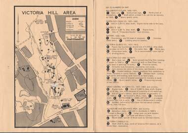
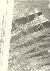
Map - VICTORIA HILL AREA
... ... New Chum anticline...History House 11 Mackenzie Street Bendigo goldfields MAP Bendigo victoria hill Victoria Hill Area Victoria Consols New Chum anticline Great Central Victoria Rae's Open Cut W Rae's Home Victoria Quartz Ballerstedt's Open Cut Lansell's 180 North Old Chum Central Nell Gwynne John Brown Factory Gold Mines Hotel Cleopatra Needle type chimney Floyd's Battery Ballerstedt's 24yd Claim Humboldt Shaft Wittscheibe's Jeweller's Shop Luffsman and Sterry's Claim Victoria Hill Reserve Mines Dept Reervation Map of Victoria Hill Area printed on yellow paper. ...Map of Victoria Hill Area printed on yellow paper. Details of tracks, cuttings, contours (in Metres) and Anticline. Location of mines, open cuts and buildings are shown. Numbers on map are: Ballerstedt's Claim 1 - 5; North Old Chum Co. 6; Lansell's 180, 7,8,11; Battery 9.10.12; Victoria Quartz Co. 13 - 17; Rae's Open Cut and Vicinity 18 - 28, Great Central Victoria Co 29 - 36, Adventure and Advance Area and vicinity 37 - 40 and Victoria Consols Co 41.map, bendigo, victoria hill, victoria hill area, victoria consols, new chum anticline, great central victoria, rae's open cut, w rae's home, victoria quartz, ballerstedt's open cut, lansell's 180, north old chum, central nell gwynne, john brown factory, gold mines hotel, cleopatra needle type chimney, floyd's battery, ballerstedt's 24yd claim, humboldt shaft, wittscheibe's jeweller's shop, luffsman and sterry's claim, victoria hill reserve, mines dept reervation -
 Bendigo Historical Society Inc.
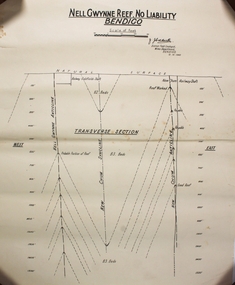
Plan - Nell Gwynne Reef
... Caidwell District Field Geologist, Mines Department BENDIGO 12. 10. 1940 Underneath there is a drawing labeled TRANVERSE SECTION showing East, Natural surface, Nell Gwynne Anticline, Railway Goldfields shaft, New Chum Syncline, New Chum Railway Shaft, New Chum Anticline, West Forms part of the Margaret Roberts Collection ...Caidwell District Field Geologist, Mines Department BENDIGO 12. 10. 1940 Underneath there is a drawing labeled TRANVERSE SECTION showing East, Natural surface, Nell Gwynne Anticline, Railway Goldfields shaft, New Chum Syncline, New Chum Railway Shaft, New Chum Anticline, West Forms part of the Margaret Roberts Collection Plan Nell Gwynne Reef ...Mr. J. J. Caldwell was appointed Officer in charge of the Bendigo Geological branch of the Victorian Mine s Department in 1923. He received his early training in the Castlemaine and Bendigo Schools of Mines and later at the Melbourne Technical College. He entered the Mines Department in 1900 as a junior chainman. Draftsman's drawing in black ink on off-white paper. Printed at the top NELL GWYNNE REEF . NO LIABILTY BENDIGO Scale of feet (100 feet to an inch) Singed J. Caidwell District Field Geologist, Mines Department BENDIGO 12. 10. 1940 Underneath there is a drawing labeled TRANVERSE SECTION showing East, Natural surface, Nell Gwynne Anticline, Railway Goldfields shaft, New Chum Syncline, New Chum Railway Shaft, New Chum Anticline, West Forms part of the Margaret Roberts Collection bendigo, margaret roberts, gold, map, mine, j. j. caldwell -
 Bendigo Historical Society Inc.
Document - LONG GULLY HISTORY GROUP COLLECTION: VICTORIA HILL
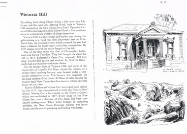
... The second page has a map of the Victoria Hill Area showing streets and the New Chum Anticline, a sketch of Ballerstedt's Open Cut and a Key to Victoria Hill Area Map. ...History House 11 Mackenzie Street Bendigo goldfields BENDIGO History long gully history group The Long Gully History Group - Victoria Hill Gold Mines Hotel Christopher Ballerstedt Theodore Ballerstedt Ballerstedt's Open Cut Lansell's 180 Mine Little 180 Mine New Chum Syncline Battery Victoria Reef Quartz Mining Co Victoria Quartz New Chum Drainage Scheme A Roberts and Sons Tributors William Rae's Bon Accord Mine and Open Cut William Rae Adventure and Advance open Cuts Central Nell Gwynne Heinz Butcher Shop Three pages numbered 18/19, 20/21 and 22/23 titled Victoria Hill. First page has some information on Victoria Hill, a sketch of W Rae's Home and Rae's Open cut. The second page has a map of the Victoria Hill Area showing streets and the New Chum Anticline ...Three pages numbered 18/19, 20/21 and 22/23 titled Victoria Hill. First page has some information on Victoria Hill, a sketch of W Rae's Home and Rae's Open cut. The second page has a map of the Victoria Hill Area showing streets and the New Chum Anticline, a sketch of Ballerstedt's Open Cut and a Key to Victoria Hill Area Map. The third page mentions the Victoria Quartz mine, Tributors and quartz roasting. It also has sketch of a 20 Head Crushing Battery, Victoria Hill.bendigo, history, long gully history group, the long gully history group - victoria hill, gold mines hotel, christopher ballerstedt, theodore ballerstedt, ballerstedt's open cut, lansell's 180 mine, little 180 mine, new chum syncline battery, victoria reef quartz mining co, victoria quartz, new chum drainage scheme, a roberts and sons, tributors, william rae's bon accord mine and open cut, william rae, adventure and advance open cuts, central nell gwynne, heinz butcher shop -
 Bendigo Historical Society Inc.
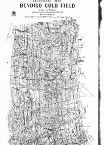
Map - LONG GULLY HISTORY GROUP COLLECTION: GEOLOGICAL MAP - BENDIGO GOLD FIELD
... History House 11 Mackenzie Street Bendigo goldfields BENDIGO History long gully history group The Long Gully History Group - Geological map - Bendigo Gold Field Mines Department H Herman Lightning Hill Line Hustlers Line Derby Line Paddy's Gully Line Garden Gully Line Deborah Line Sheepshead Line New Chum Line Nell Gwynne Line British and Foreign Line Napoleon Line Carshalton Line Thistle Line Christmas Line Lancashire Line Copy of a Geological Map of the Bendigo Gold Field. Map shows Lines of Reef, Anticlines ...Copy of a Geological Map of the Bendigo Gold Field. Map shows Lines of Reef, Anticlines, Synclines, Shafts, Alluvial Contours Gullies and some street names. Copy is hard to read. There are two pages.bendigo, history, long gully history group, the long gully history group - geological map - bendigo gold field, mines department, h herman, lightning hill line, hustlers line, derby line, paddy's gully line, garden gully line, deborah line, sheepshead line, new chum line, nell gwynne line, british and foreign line, napoleon line, carshalton line, thistle line, christmas line, lancashire line -
 Bendigo Historical Society Inc.
Map - LONG GULLY HISTORY GROUP COLLECTION: BENDIGO GOLD FIELD - GOLDEN SQUARE GEOLOGICAL SURVEY OF VICTORIA
... History House 11 Mackenzie Street Bendigo goldfields BHS Collection BENDIGO History long gully history group The Long Gully History Group - Bendigo Gold Field - Golden Square Geological Survey of Victoria North Bendigo State School Reserve Hospital Reserve Benevolent Asylum Reserve Empire Hill Richmond Hill Raes Hill South End Hill Victoria Hill New Chum Hill Iron Bark Hill Redan Hill View Hill Hustlers Hill Camp Hill Part of a map of the Bendigo Gold Field - Golden Square. Geological Survey of Victoria. Shown are reefs, faults and anticlines ...BHS CollectionPart of a map of the Bendigo Gold Field - Golden Square. Geological Survey of Victoria. Shown are reefs, faults and anticlines. Many of the mines are shown on the map. Gullies, hills and streets are also shown.bendigo, history, long gully history group, the long gully history group - bendigo gold field - golden square geological survey of victoria, north bendigo state school reserve, hospital reserve, benevolent asylum reserve, empire hill, richmond hill, raes hill, south end hill, victoria hill, new chum hill, iron bark hill, redan hill, view hill, hustlers hill, camp hill -
 Bendigo Historical Society Inc.
Document - ALBERT RICHARDSON COLLECTION: SECRETARY FOR MINES ANNUAL REPORT 1911
... Longitudinal sections along the lines of reefs or anticlines within the 8 mile block at Bendigo are shown in a diagram' (diagram not included with notes) Mines and reef lines mentioned in the report are : New Chum line, New Chum Railway mine, Catherine United mine, Hercules and Energetic mine, Garden Gully, Hustlers and Redan, Sheepshead Reef, Sea Mine, Garden Gully, Miller's line of reef and Bendigo Development Mine. ...Longitudinal sections along the lines of reefs or anticlines within the 8 mile block at Bendigo are shown in a diagram' (diagram not included with notes) Mines and reef lines mentioned in the report are : New Chum line, New Chum Railway mine, Catherine United mine, Hercules and Energetic mine, Garden Gully, Hustlers and Redan, Sheepshead Reef, Sea Mine, Garden Gully, Miller's line of reef and Bendigo Development Mine. ...Three page typed report titled ' Notes on diagram showing pitch lines, Bendigo'. Longitudinal sections along the lines of reefs or anticlines within the 8 mile block at Bendigo are shown in a diagram' (diagram not included with notes) Mines and reef lines mentioned in the report are : New Chum line, New Chum Railway mine, Catherine United mine, Hercules and Energetic mine, Garden Gully, Hustlers and Redan, Sheepshead Reef, Sea Mine, Garden Gully, Miller's line of reef and Bendigo Development Mine. The 'old stacks' or chimneys, on Bendigo are described. 'Among the earliest of the stacks built at Bendigo in connexion with Quartz crushing plant, are the two figured in this Annual report No 1 was situate in Sailor's Gully but was demolished about three years ago. This, if not the first, must have been one of the first built, for it had a stone inserted on which chiselled the date 1854. It was built altogether of rough masonry. The other, No. 2, is still standing at the Sheepshead line and was apparently of later date, the upper portion being of brick. They are intersting landmarks of an era that is rapidly passing.' Map attached to report showing location of stacks. Stack at Sailors Gully was near the corner of Murchison Street and Lester Street. The stack at Sheepshead ( Deborah Triangle area) was near the intersection of Belle Vue Road and Adam Street.bendigo, mining, pitch lines bendigo -
 Bendigo Historical Society Inc.
Map - SECTIONS ACROSS BENDIGO GOLDFIELD
... anticlines, synclines, faults, stratigraphical zones and mines along the reef lines. Key shows rock types Castlemaine, Bendigo B1, B2, B3 and B4, and Lancefieldian. First part of map shows sections A-A, B-B and C-C. Reef lines drawn with mines listed: Fault line shown are the Carshalton, Stafford, New Chum...anticlines, synclines, faults, stratigraphical zones and mines along the reef lines. Key shows rock types Castlemaine, Bendigo B1, B2, B3 and B4, and Lancefieldian. First part of map shows sections A-A, B-B and C-C. Reef lines drawn with mines listed: Fault line shown are the Carshalton, Stafford, New Chum ...Map in three sections showing sections across Bendigo Gold Field, showing anticlines, synclines, faults, stratigraphical zones and mines along the reef lines. Key shows rock types Castlemaine, Bendigo B1, B2, B3 and B4, and Lancefieldian. First part of map shows sections A-A, B-B and C-C. Reef lines drawn with mines listed: Fault line shown are the Carshalton, Stafford, New Chum, Virginia and Clarence. A datum line shows 600 ft above sea level. On bottom of plan: ' Prepared in the Geological Survey Office, Bendigo, under the direction of H. Herman, late Director of Geological Survey, from surveys by H.S. Whitelaw, Field Geologist, assisted by E.S. Usher, A.J.J. Moore and R.A. Keble.' Second section of map shows sections D-D, and E-E. Fault lines listed are the Tambour Major fault, Carshalton fault, Stafford fault, Nell Gwynne fault, New Chum fault, Deborah fault. Third section shows sections F-F and G-G. Fault lines listed are the Bird Reef fault, Kangaroo Gully fault, Langdon fault, Carshalton fault, Nell Gwynne fault, Spring Gully fault, Hustlers fault, Gravel Hill fault, Ordes fault, Thanet fault. This map forms part of the Geological Survey of Victoria, Structure of Bendigo Goldfield report, No. 47, 1923. H.Herman, late Director of Geological Survey.Geological Survey of Victoriabendigo, gold mining, reef line maps -
 Bendigo Historical Society Inc.
Newspaper - Kangaroo Flat Gold Mine Collection: Gold search continues, 2.9.2000
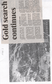
... anticline axes and reverse faulting. The gold within the quartz reefs is typically both coarse grained and erratically distributed. Bendigo Mining N.L. Bendigo mining gold Kangaroo Flat Doug Buerger Garden Gully reef New Chum reef Bendigo Advertiser article attached to a photocopy of an underground rock formation. ...New Bendigo Gold Project The Bendigo goldfield is centred on the urban area of Bendigo (population approximately 60 000) in central Victoria, 130 km north west of Melbourne, Australia. Gold was discovered at Bendigo in 1851 and production continued through to 1954. The Bendigo goldfield is the second largest goldfield in total gold produced in Australia, after Kalgoorlie's Golden Mile with a total production of 22 million oz. The geology of the Bendigo Field consists of a series of tightly folded, interbedded sandstone and shale sediments. Within the sediments the gold mineralisation is hosted in quartz reefs or ribbons closely associated with anticline axes and reverse faulting. The gold within the quartz reefs is typically both coarse grained and erratically distributed.Bendigo Advertiser article attached to a photocopy of an underground rock formation. Photocopy date stamped 21.8.2000. Headline on newspaper article: 'Gold search continues'. Content describes exploration on the New Chum line of reef 'down to 1500 metres below the surface'. Doug Buerger is quoted discussing the 10 million ounce potential of the New Bendigo gold project. The Garden Gully line of reef is being tested for unmined ribbons on the reefline. bendigo mining n.l., bendigo, mining, gold, kangaroo flat, doug buerger, garden gully reef, new chum reef -
Bendigo Historical Society Inc.
Document - History Notes - Information on Mining, statistics and early development of Bendigo, 1840-1990 approx
... anticlines and synclines. Major Productive Reefs: Hustlers, Garden Gully, Paddy's Gully, Sheepshead, New Chum, Nell Gwynne, and Carshalton.Mining Process: Gold is found in quartz lodes, extracted, crushed, and separated using mercury amalgamation. ...anticlines and synclines. Major Productive Reefs: Hustlers, Garden Gully, Paddy's Gully, Sheepshead, New Chum, Nell Gwynne, and Carshalton.Mining Process: Gold is found in quartz lodes, extracted, crushed, and separated using mercury amalgamation. ...Saddle, Fault, and Spur reefs are the main types, found in Ordovician slates and sandstones folded into anticlines and synclines. Major Productive Reefs: Hustlers, Garden Gully, Paddy's Gully, Sheepshead, New Chum, Nell Gwynne, and Carshalton.Mining Process: Gold is found in quartz lodes, extracted, crushed, and separated using mercury amalgamation. From 1851–1949, over 21 million ounces of gold were produced, valued at approximately £323 million (1964 prices). Located Bendigo is in central Victoria, north of the Dividing Range, between Campaspe Valley and Loddon flats; 100 miles from Melbourne. The City area is 8,030 acres; population around 40,000 (city), 47,000 (district).Climate is temperate, with average rainfall of 20 inches, and 320 sunny days per year. Gold First discovered in 1851 at Golden Square. Bendigo Became a municipal district in 1855, a town in 1861, a city in 1871, and changed its name from Sandhurst to Bendigo in 1891. Key Events: Establishment of hospital, police court, churches, schools, and infrastructure like railways and water supply.Governance and Civic Structure. Council Structure: 3 wards, each with 3 councillors serving 3-year terms; mayor elected by councillors. Main revenue from rates and property; principal duties include public works, health, parks, and enforcement of by-laws. Major Projects: Olympic swimming pool, market extensions, park improvements, road and drainage works.Economy and IndustryCommerce: 730 retail shops, 260 factories, and a major livestock market.Principal Industries: Meat processing, manufacturing (including ordnance, textiles, engineering), fruit and food processing, and egg production. Bendigo is Noted for sheep, lamb, fruit (especially tomatoes and apples), and dairy. Major rail and road hub with connections across Victoria and to New South Wales; tram and bus services.Education: Institute of Technology, Teachers College, multiple secondary and primary schools, and special education facilities. Several hospitals, aged care homes, and health services. 486 acres of parks and gardens, extensive sports facilities, and Lake Eppalock for water sports. Wide range of community, cultural, and sporting organizations. Regional library, art gallery, music and drama societies. Notable Figures and HeritageGeorge Lansell: Known as the "Gold King," a key figure in Bendigo's mining history. Transformation: From a sheep run to a major goldfield and then to a modern city with significant infrastructure and cultural assets. Motto Coat of Arms: Features symbols representing gold mining, agriculture, pioneering, and fruit growing.Motto: "Progress" in gold on a purple ribbon.Bendigo's history is marked by rapid growth from gold discovery, strong civic development, and a diverse economy, making it a significant regional center in Victoria.History Notes - Information on Mining, statistics and early development of Bendigo - author unknown This item contains the following document: 11217.65a Twelve Foolscap typed pages with information on Bendigonon-fictionbendigo, fortuna, george lansell, development of bendigo