Showing 14 items matching " parish of neilborough"
-
 Bendigo Historical Society Inc.
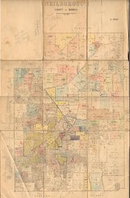
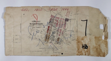
Map - JACK FLYNN COLLECTION: NEILBOROUGH, 13/10/1927
... ...parish plan...Neilborough...Map: Parish of Neilborough, County of Bendigo. Parish plan....Butson Map: Parish of Neilborough, County of Bendigo. Parish plan. ...Map: Parish of Neilborough, County of Bendigo. Parish plan.Photo Lithographed at the Department of Lands and Survey, Melbourne by W.J. Butsonmap, bendigo, parish plan, neilborough -
 Bendigo Historical Society Inc.
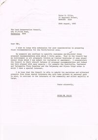
Document - PETER ELLIS COLLECTION: LETTER, 20th August, 1980
... ... Parish of Neilborough...History House 11 Mackenzie Street Bendigo goldfields PERSON Individual peter ellis oam Peter Ellis Collection Land Conservation Council Kamarooka State park Whipstick State park Eucalyptus Oil Production FNCV Victorian Naturalist D J Paton Bendigo Field Naturalists Club Wellsford Forest Mandurang Forest Main Coliban Channel Lockwood Forest Waanyaras Fryerstown Whipstick Hill (Flagstaff Hill) Parish of Neilborough Old Underground Water Race Puddling Machine SRWSC Letter (11 Pages) from Peter N Ellis to the Land Conservation Council. ...Letter (11 Pages) from Peter N Ellis to the Land Conservation Council. Letter refers to proposed State parks - Kamarooka State Park and Whipstick State Park. other areas mentioned are the Wellsford Forest, Mandurang Forest, Lockwood Forest, Waanyaraa, Fryerstown, Whipstick Hill (Flagstaff Hill) and Black Rock. Other areas are Wellsford/Axedale Forest, Sugarloaf Range, Mandurang Forest, Main Coliban Channel, Lockwood Forest, Tarnagulla/Dunolly Forest, Fryerstown, Seven Sisters (between Huntly and Goornong). Plant and tree life in each area is mentioned including the cutting of eucalypt for the production of Eucalyptus oil.person, individual, peter ellis oam, peter ellis collection, land conservation council, kamarooka state park, whipstick state park, eucalyptus oil production, fncv victorian naturalist, d j paton, bendigo field naturalists club, wellsford forest, mandurang forest, main coliban channel, lockwood forest, waanyaras, fryerstown, whipstick hill (flagstaff hill), parish of neilborough, old underground water race, puddling machine, srwsc -
 Bendigo Historical Society Inc.
Map - RAYWOOD, 18/09/1930
... Map: Township of Raywood, Parish of Neilborough,County of Bendigo. Parish plan (number 270 in map cupboard 1)...History House 11 Mackenzie Street Bendigo goldfields MAP Bendigo township Raywood Map: Township of Raywood, Parish of Neilborough,County of Bendigo. Parish plan (number 270 in map cupboard 1) Map RAYWOOD ...Map: Township of Raywood, Parish of Neilborough,County of Bendigo. Parish plan (number 270 in map cupboard 1)map, bendigo, township, raywood -
Bendigo Historical Society Inc.
Map - KAMAROOKA STATE FOREST, 23/11/1910
... Map: Part of Subdivision of kamarooka State Forest, Parishes of Neilborough and Whirrakee, County of Bendigo. ...History House 11 Mackenzie Street Bendigo goldfields MAP Bendigo subdivision Kamarooka State Forest Subdivision Whirrakee Map: Part of Subdivision of kamarooka State Forest, Parishes of Neilborough and Whirrakee, County of Bendigo. ...Map: Part of Subdivision of kamarooka State Forest, Parishes of Neilborough and Whirrakee, County of Bendigo. Parish plan (number 287 in map cupboard 1)map, bendigo, subdivision, kamarooka state forest, subdivision, whirrakee -
 Bendigo Historical Society Inc.
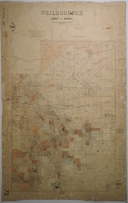
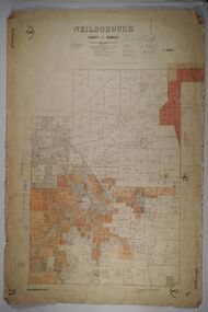
Map - NEILBOROUGH, 21/01/1875
... ...parish plan...Neilborough...Map: Parish of Neilborough, County of Bendigo. Hand draughted Parish plan. ...History House 11 Mackenzie Street Bendigo goldfields MAP Bendigo parish plan Neilborough G. Black W.A. Taylor Map: Parish of Neilborough, County of Bendigo. ...Map: Parish of Neilborough, County of Bendigo. Hand draughted Parish plan. Resurveyed by Mr Assistant-Surveyor G Black. Drawn by W A Taylor. Map dated 21/1/1875.map, bendigo, parish plan, neilborough, g. black, w.a. taylor -
 Bendigo Historical Society Inc.
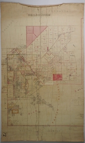
Map - NEILBOROUGH, 6/12/1882
... ...parish plan...Neilborough...Map: Parish of Neilborough, County of Bendigo. Parish plan. ...History House 11 Mackenzie Street Bendigo goldfields MAP Bendigo parish plan Neilborough J A Morrison Jr. Harvey J V Walshe Map: Parish of Neilborough, County of Bendigo. ...Map: Parish of Neilborough, County of Bendigo. Parish plan. J A Morrison Junior June 1877. Examined by ? Harvey 21/8/1877. Additions made by J V Walshe24/10/82. Examined by E D 39/10/82.map, bendigo, parish plan, neilborough, j a morrison jr., harvey, j v walshe -
Bendigo Historical Society Inc.
Map - RAYWOOD GOLD FIELD MAP, 1902
... of Yallook, Parish of Neilborough, Yarraberb, Mushroom Flat, Murray Valley Plain, Eaglehawk and Kerang Railway, Green Hill, Doughboy, Redmond's Gully, Pickpocket Lead, Raywood Lead, Inglewood Lead, Shaw's Road, Nuggety Shaft, Barkly Shaft, Maori Bend... of Yallook, Parish of Neilborough, Yarraberb, Mushroom Flat, Murray Valley Plain, Eaglehawk and Kerang Railway, Green Hill, Doughboy, Redmond's Gully, Pickpocket Lead, Raywood Lead, Inglewood Lead, Shaw's Road, Nuggety Shaft, Barkly Shaft, Maori Bend Map RAYWOOD GOLD FIELD MAP ...Map. Raywood Gold Field Map. Linen backed map of Raywood and Neilborough Township and surrounds showing the location of varying underground workings. Surveyed by H S Whitelaw 1/6/02. It shows underground workings from The Perseverance Party and moreshed and Party and underground workings on the Old Pioneer Reef. Mentions the Parish of Yallook, Parish of Neilborough, Yarraberb, Mushroom Flat, Murray Valley Plain, Eaglehawk and Kerang Railway, Green Hill, Doughboy, Redmond's Gully, Pickpocket Lead, Raywood Lead, Inglewood Lead, Shaw's Road, Nuggety Shaft, Barkly Shaft, Maori Bendmap, gold field map, raywood gold field map, neilborough, h s whitelaw, geological survey of victoria bulletin no 12 plate 11 -
 Bendigo Historical Society Inc.
Document - PETER ELLIS COLLECTION: DRAFT OF WHIPSTICK SUBMISSION
... Locations are in the Parishes of Whirrakee, Egerton, Neilborough, Nerring, Huntly and Eaglehawk. ...Locations are in the Parishes of Whirrakee, Egerton, Neilborough, Nerring, Huntly and Eaglehawk. ...Appendices to Draft of Whipstick Submission to LCC, Appendix 1. Locations are in the Parishes of Whirrakee, Egerton, Neilborough, Nerring, Huntly and Eaglehawk. Soil types are mentioned and also the Whipstick Scrub area. Type of park is mentioned.bendigo, national parks, peter ellis collection, kamarooka forest, egerton forest, lightning hill recreation reserve, eaglehawk rifle range, new moon mines, d j paton, bendigo field naturalists club, land conservation council, eucalyptus oil production -
Bendigo Historical Society Inc.
Map - CAMPBELL COLLECTION: BENDIGO AND DISTRICT MAPS, 11-4-29
... Huntly, Parishes of Huntly Nerring and Neilborough. Scale 20 chains to 1 inch. ...Huntly, Parishes of Huntly Nerring and Neilborough. Scale 20 chains to 1 inch. ...Map. Huntly, Parishes of Huntly Nerring and Neilborough. Scale 20 chains to 1 inch. Total area 4738 acres. Eaglehawk. Prepared in W.J.B. from A. and C.L. Plans by W.J.Galbraith 11-4-29. (number 396 in map cupboard 1)W.J.Galbraithmap, bendigo, agricultural lands -
 Bendigo Historical Society Inc.
Document - MCCOLL, RANKIN AND STANISTREET COLLECTION: LEASE AGREEMENT, 24th November, 1933
... These men are the holders of an application for Gold Mining lease 10073 comprising about 90 acres in the Parishes of Yarraberb and Neilborough. The company is being formed to acquire the application for the lease and to carry out mining operations on and in the land comprised in the lease application. ...These men are the holders of an application for Gold Mining lease 10073 comprising about 90 acres in the Parishes of Yarraberb and Neilborough. The company is being formed to acquire the application for the lease and to carry out mining operations on and in the land comprised in the lease application. ...Manilla Envelope containing 3 copies of a Lease agreement between John Taylor of California Gully and John Severn Barker of Jobs Gully for a company called the Garden Gully and Moon Extended Gold Mines NL. These men are the holders of an application for Gold Mining lease 10073 comprising about 90 acres in the Parishes of Yarraberb and Neilborough. The company is being formed to acquire the application for the lease and to carry out mining operations on and in the land comprised in the lease application. Dated 24th November 1933. Also in the envelope is a lease document for mining Lease No. 9993, for the Central Garden Gully Gold Mining Co. NL which includes a map of the lease. Written in pencil on the front of the lease is : allowed to lapse.gold, mining, lease agreement, gold mining, garden gully and moon extended mines, central garden gully -
Bendigo Historical Society Inc.
Map - CAMPBELL COLLECTION: BENDIGO AND DISTRICT MAPS, 11-4-29
... Huntly, Parishes of Huntly, Nerring and Neilborough. Scale 20 chains to 1 inch. ...Huntly, Parishes of Huntly, Nerring and Neilborough. Scale 20 chains to 1 inch. ...Map. Huntly, Parishes of Huntly, Nerring and Neilborough. Scale 20 chains to 1 inch. Total area 4738 acres. Prepared in W.P.B. from A and C.L. Plans by W.J. Galbraith 11-4-29. Eaglehawk. IN PENCIL top right of map: Euc areas 1974 Scott & Cole Comp 5,6,7,8,9,12,13. Laurie C.Raynor 10,11,17, Part 16 South of Scotsmans Track, J.T Pierce 14,15,16 North of Scotsman Track. From Neilborough. G.Ward. A.Sloan. K.Walker at bottom of map. (number 368 in map cupboard 1)W.J.Galbraithmap, bendigo, allotments -
 Bendigo Historical Society Inc.
Map - NEILBOROUGH RAVENSWOOD, October 21 1859
... Map:Township of Neilborough, Elysian Flat, near Sandhurst,County unnamed. Parish plan. Backing is a part of Ravenswood Township map....History House 11 Mackenzie Street Bendigo goldfields MAP Bendigo Neilborough Elysian Flat Ravenswood Map:Township of Neilborough, Elysian Flat, near Sandhurst,County unnamed. Parish plan. Backing is a part of Ravenswood Township map. ...Map:Township of Neilborough, Elysian Flat, near Sandhurst,County unnamed. Parish plan. Backing is a part of Ravenswood Township map.map, bendigo, neilborough, elysian flat, ravenswood -
 Bendigo Historical Society Inc.
Map - NEILBOROUGH, 27/09/1904
... ...parish plan...Neilborough...Map: Neilborough, County of Bendigo. Parish plan...Parish plan Map NEILBOROUGH ...Map: Neilborough, County of Bendigo. Parish planmap, bendigo, parish plan, neilborough -
Bendigo Historical Society Inc.
Map - NEILBOROUGH, 15/10/1877
... ...parish plan...Neilborough...Map: Neilborough, County of Bendigo. Parish plan (number 301 in map cupboard 1)...History House 11 Mackenzie Street Bendigo goldfields MAP Bendigo parish plan Neilborough Elysian Flat Map: Neilborough, County of Bendigo. ...Map: Neilborough, County of Bendigo. Parish plan (number 301 in map cupboard 1)map, bendigo, parish plan, neilborough, elysian flat