Showing 6 items matching " part of a plan of mines along the new chum line of reef"
-
 Bendigo Historical Society Inc.
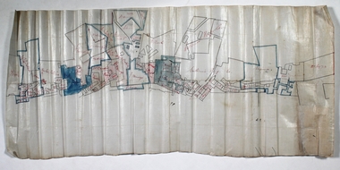
Document - NEW CHUM LINE OF REEF - PART OF A PLAN OF MINES ALONG THE NEW CHUM LINE OF REEF
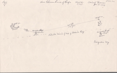
... NEW CHUM LINE OF REEF - PART OF A PLAN OF MINES ALONG THE NEW CHUM LINE OF REEF...New Chum Line Of Reef... Part of a plan of mines along the New Chum Line Of Reef... Caleb Thomas... Hercules Mine...History House 11 Mackenzie Street Bendigo goldfields DOCUMENT Gold New Chum Line Of Reef Part of a plan of mines along the New Chum Line Of Reef Caleb Thomas Hercules Mine Energetic Mine Energetic Coy Sketch of mines along the New Chum Line of Reef Sheet No 1 (811) Caleb Thomas Jun 28, 1879. ...Sketch of mines along the New Chum Line of Reef Sheet No 1 (811) Caleb Thomas Jun 28, 1879. Mines mentioned are the Hercules and the Energetic. The others are shaft numbers. Measurements between each in feet and yards. Probable course of cap of Victoria Reef drawn in.document, gold, new chum line of reef, part of a plan of mines along the new chum line of reef, caleb thomas, hercules mine, energetic mine, energetic coy -
 Bendigo Historical Society Inc.
Map - SECTIONS ACROSS BENDIGO GOLDFIELD
... mines along the reef lines. Key shows rock types Castlemaine, Bendigo B1, B2, B3 and B4, and Lancefieldian. First part of map shows sections A-A, B-B and C-C. Reef lines drawn with mines listed: Fault line shown are the Carshalton, Stafford, New Chum, Virginia and Clarence. A datum line shows 600 ft above sea level. On bottom of plan...reef line maps Geological Survey of Victoria Map in three sections showing sections across Bendigo Gold Field, showing anticlines, synclines, faults, stratigraphical zones and mines along the reef lines. Key shows rock types Castlemaine, Bendigo B1, B2, B3 and B4, and Lancefieldian. First part of map shows sections A-A, B-B and C-C. Reef lines drawn with mines listed: Fault line shown are the Carshalton, Stafford, New Chum, Virginia and Clarence. A datum line shows 600 ft above sea level. On bottom of plan ...Map in three sections showing sections across Bendigo Gold Field, showing anticlines, synclines, faults, stratigraphical zones and mines along the reef lines. Key shows rock types Castlemaine, Bendigo B1, B2, B3 and B4, and Lancefieldian. First part of map shows sections A-A, B-B and C-C. Reef lines drawn with mines listed: Fault line shown are the Carshalton, Stafford, New Chum, Virginia and Clarence. A datum line shows 600 ft above sea level. On bottom of plan: ' Prepared in the Geological Survey Office, Bendigo, under the direction of H. Herman, late Director of Geological Survey, from surveys by H.S. Whitelaw, Field Geologist, assisted by E.S. Usher, A.J.J. Moore and R.A. Keble.' Second section of map shows sections D-D, and E-E. Fault lines listed are the Tambour Major fault, Carshalton fault, Stafford fault, Nell Gwynne fault, New Chum fault, Deborah fault. Third section shows sections F-F and G-G. Fault lines listed are the Bird Reef fault, Kangaroo Gully fault, Langdon fault, Carshalton fault, Nell Gwynne fault, Spring Gully fault, Hustlers fault, Gravel Hill fault, Ordes fault, Thanet fault. This map forms part of the Geological Survey of Victoria, Structure of Bendigo Goldfield report, No. 47, 1923. H.Herman, late Director of Geological Survey.Geological Survey of Victoriabendigo, gold mining, reef line maps -
 Bendigo Historical Society Inc.
Document - NEW CHUM LINE OF REEF - PLAN OF MINES ALONG PART OF THE NEW CHUM LINE OF REEF
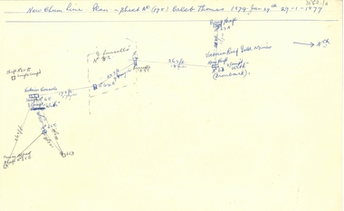
... New Chum Line Of Reef... Plan of Mines along part of the New Chum Line Of Reef... Caleb Thomas... Prince Alfred Mine...History House 11 Mackenzie Street Bendigo goldfields DOCUMENT Gold New Chum Line Of Reef Plan of Mines along part of the New Chum Line Of Reef Caleb Thomas Prince Alfred Mine Victoria Consols G Lansell's No 83 Ironbark Victoria Reef Gold Mines Sketch of some mines along the New Chum Line of Reef. ...Sketch of some mines along the New Chum Line of Reef. Sheet No (178) Caleb Thomas 1879 Jan 29th. Mines mentioned are: Prince Alfred, Victoria Consols, G Lansell's No 83. Some mines are only a number. Victoria Reef Gold Mines are mentioned. Distances in feet or yards between them.document, gold, new chum line of reef, plan of mines along part of the new chum line of reef, caleb thomas, prince alfred mine, victoria consols, g lansell's no 83, ironbark, victoria reef gold mines -
 Bendigo Historical Society Inc.
Document - NEW CHUM LINE OF REEF - SKETCH OF MINES ALONG THE NEW CHUM LINE OF REEF
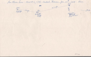
... Sketch of mines along part of the New Chum Line Of Reef. Sheet No 1 (179). Caleb Thomas Jan 28th 1879. Plan...History House 11 Mackenzie Street Bendigo goldfields DOCUMENT Gold New Chum Line Of Reef Sketch of Mines along the New Chum Line Of Reef Hercules Energetic Caleb Thomas Sketch of mines along part of the New Chum Line Of Reef. Sheet No 1 (179). Caleb Thomas Jan 28th 1879. Plan ...Sketch of mines along part of the New Chum Line Of Reef. Sheet No 1 (179). Caleb Thomas Jan 28th 1879. Plan. Hercules and Energetic Mines on drawing, 430 feet apart. Albert Richardson Collectiondocument, gold, new chum line of reef, sketch of mines along the new chum line of reef, hercules, energetic, caleb thomas -
 Bendigo Historical Society Inc.
Plan - Monument Hill Consolidated Gold Mine
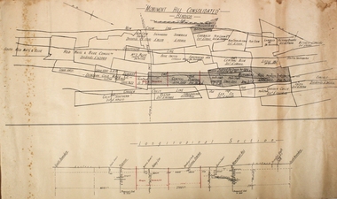
... plan of leases along Sheepshead, Garden Gully, New Chum and Deborah lines of reef. Longitudinal section of mines along reef line on bottom of plan. Printed across top of plan: 'Monument Hill Consolidated Bendigo' Plan forms part of the Margaret Roberts Collection....plan of leases along Sheepshead, Garden Gully, New Chum and Deborah lines of reef. Longitudinal section of mines along reef line on bottom of plan. Printed across top of plan: 'Monument Hill Consolidated Bendigo' Plan forms part of the Margaret Roberts Collection. ...Printed on buff paper, plan of leases along Sheepshead, Garden Gully, New Chum and Deborah lines of reef. Longitudinal section of mines along reef line on bottom of plan. Printed across top of plan: 'Monument Hill Consolidated Bendigo' Plan forms part of the Margaret Roberts Collection.gold mining, gold, bendigo, monument hill consolidated -
 Bendigo Historical Society Inc.
Plan - New Franklin
... gold mining gold Bendigo Pearl Gold Mine Franklin Gold Mine New Chum reef line White waxed paper, mining leases drawn along reef line. Handwritten annotations on map. Label states: Pearl, New Franklin on New Chum Line. 15 BC 304 printed on label of plan. Plan forms part ...White waxed paper, mining leases drawn along reef line. Handwritten annotations on map. Label states: Pearl, New Franklin on New Chum Line. 15 BC 304 printed on label of plan. Plan forms part of the Margaret Roberts Collection.gold mining, gold, bendigo, pearl gold mine, franklin gold mine, new chum reef line