Showing 3846 items matching " road map"
-
 Phillip Island and District Historical Society Inc.
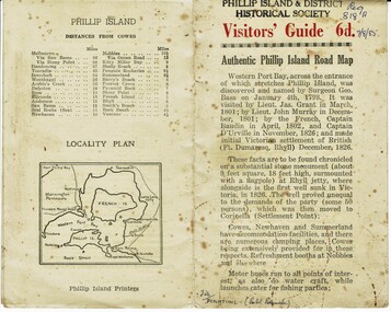
Booklet, Authentic Phillip Island Road Map, Pre 1960
... Authentic Phillip Island Road Map......Road map...Visitors' Guide 6d Authentic Phillip Island Road Map...Authentic Phillip Island Road Map Booklet Phillip Island Printers ...Tourist brochure printed by the Phillip Island Printers pre 1960HistoricalSmall cream coloured brochure with details of accommodation, transport and animals. Inside is a map of the Island with numbered points of interest. There is also a plan of Cowes and drawings of animals.Visitors' Guide 6d Authentic Phillip Island Road Maptourist brochure, road map -
 Dutch Australian Heritage Centre Victoria
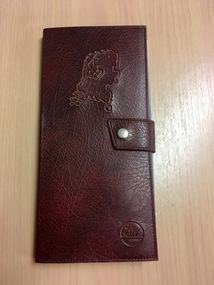
Road Map, Nederland
... Road Map...Cleverly folded 1:250,000 road map produced in Dutch, French, German and English containing not only the Dutch road network but also much information of interest to tourists. ...Falk Plan. Road Map. Netherlands. Repeated in Dutch, French and German....Optimal ease of use through patented Falk folding mode. Nederland Road Map ...Cleverly folded 1:250,000 road map produced in Dutch, French, German and English containing not only the Dutch road network but also much information of interest to tourists. It is enclosed in a brown imitation leather cover that closes with a stud. Optimal ease of use through patented Falk folding mode.Falk Plan. Road Map. Netherlands. Repeated in Dutch, French and German. -
 Glenelg Shire Council Cultural Collection
Map - Map - RACV Road Map, 1970s
... Map - RACV Road Map...... road map...RACV road map, Warrnambool District, Port Fairy to Lorne. ...Glenelg Shire Council Cultural Collection History House Cliff Street Portland great-ocean-road RACV road touring road map Victoria RACV road map, Warrnambool District, Port Fairy to Lorne. ...RACV road map, Warrnambool District, Port Fairy to Lorne. Large coloured map of Warrnambool District. Small maps of Apollo Bay, Colac, Camperdown, Tower Hill and Warrnambool. When folded, black and white photo on cover of 12 Apostlesracv, road touring, road map, victoria -
 Bendigo Historical Society Inc.
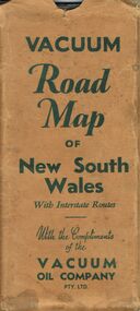
Document - BILL ASHMAN COLLECTION: VACUUM ROAD MAP OF NEW SOUTH WALES
... BILL ASHMAN COLLECTION: VACUUM ROAD MAP OF NEW SOUTH WALES...... Vacuum Road Map of New South Wales...Vacuum Road Map of New South Wales with Interstate Routes with the Compliments of the Vacuum Oil Company Pty. ...History House 11 Mackenzie Street Bendigo goldfields MAP Bill Ashman Collection - Correspondence Vacuum Road Map of New South Wales Vacuum Oil Company Pty Ltd Clive Barass Vacuum Road Map of New South Wales with Interstate Routes with the Compliments of the Vacuum Oil Company Pty. ...Vacuum Road Map of New South Wales with Interstate Routes with the Compliments of the Vacuum Oil Company Pty. Ltd. Coloured map of NSW with car, trucks, aeroplane and petrol bowsers around the margin. Has a list of principal Towns and Distances from Sydney. On the back is Beauty Spots around Sydney, Traffic Hints, Sydney-Melbourne Routes, Short Tours Around Sydney, Outlets of Sydney, Canberra and Newcastle, What to See in Sydney, Vacuum Products, Making Sure of a Trouble-Free Trip, Super Plume or Plume and the front picture of the folded map which has a car with a lady, child and a man at the petrol bowser. Map folds up and has a brown card pocket to keep it in.map, bill ashman collection - correspondence, vacuum road map of new south wales, vacuum oil company pty ltd, clive barass -
Glenelg Shire Council Cultural Collection
Map - Map - RACV Road Map, 1970s
... Map - RACV Road Map...road touring... RACV... map...RACV road map, Portland district, Port MacDonnell to Warrnambool. ...Glenelg Shire Council Cultural Collection History House Cliff Street Portland great-ocean-road road touring RACV map RACV road map, Portland district, Port MacDonnell to Warrnambool. ...RACV road map, Portland district, Port MacDonnell to Warrnambool. Large coloured map of Portland District, small maps of Portland, Mt Gambier, Hamilton, Mount Eccles National Park, Coonawarra Wineries. When folded, black and white phot of child fishing on jetty on Moyne River, Port Fairy on coverroad touring, racv, map -
 Bendigo Historical Society Inc.
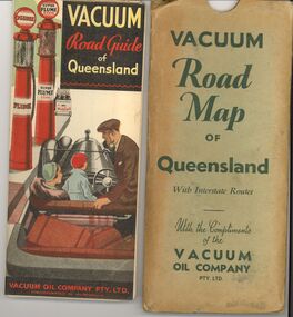
Document - BILL ASHMAN COLLECTION: VACUUM ROAD MAP QUEENSLAND
... BILL ASHMAN COLLECTION: VACUUM ROAD MAP QUEENSLAND...Vacuum Road Map of Queensland with Interstate routes with the compliments of the Vacuum Oil Company Pty Ltd....Document BILL ASHMAN COLLECTION: VACUUM ROAD MAP QUEENSLAND ...Vacuum Road Map of Queensland with Interstate routes with the compliments of the Vacuum Oil Company Pty Ltd.map, queensland, vacuum oil company -
 Bendigo Historical Society Inc.
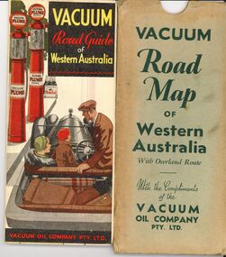
Document - BILL ASHMAN COLLECTION: VACUUM ROAD MAP WESTERN AUSTRALIA
... BILL ASHMAN COLLECTION: VACUUM ROAD MAP WESTERN AUSTRALIA...Vacuum Road Map of Western Australia with overland route with the compliments of the Vacuum Oil Company Pty Ltd....Document BILL ASHMAN COLLECTION: VACUUM ROAD MAP WESTERN AUSTRALIA ...Vacuum Road Map of Western Australia with overland route with the compliments of the Vacuum Oil Company Pty Ltd.map, western australia, vacuum oil company -
 Sunshine and District Historical Society Incorporated
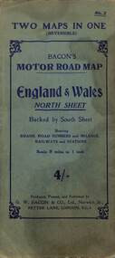
Map - Bacon's Motor Road Map - England and Wales, G.W. Bacon & Co. Ltd
... Bacon's Motor Road Map - England and Wales...A large road map. Key legend depicting colours, lines, land markings, names, places, lattitude and longitude....Map Bacon's Motor Road Map - England and Wales G.W. Bacon & Co. ... -
 Bendigo Military Museum
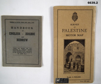
Booklet - HANDBOOK & ROAD MAP, April 1940
... HANDBOOK & ROAD MAP...It is for Australian Imperial Forces in the Middle East. 2. Palestine Road Map. It has cardboard cover and opens out to a road map, scale 1:500,000. ...Booklet HANDBOOK & ROAD MAP ...Sold by Ringarts Bookshop, Haifa1. This is a small pocket book, grey cover, black ink printing. It has words and phrases of colloquial Arabic and/or Hebrew. 32 pages. It is for Australian Imperial Forces in the Middle East. 2. Palestine Road Map. It has cardboard cover and opens out to a road map, scale 1:500,000. It has a drawing of the old section of Jerusalem on front cover.passchendaele barracks trust, 1. nr9430t, 2.9431t, ww2 -
 Bendigo Historical Society Inc.
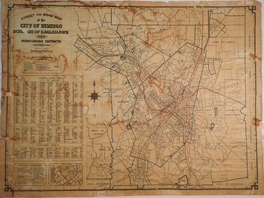
Map - CITY OF BENDIGO STREET AND ROAD MAP, 1946
... CITY OF BENDIGO STREET AND ROAD MAP...Map: City of Bendigo Street and road map, Incorporating the Borough of Eaglehawk and surrounding Districts. ...Map CITY OF BENDIGO STREET AND ROAD MAP ...Map: City of Bendigo Street and road map, Incorporating the Borough of Eaglehawk and surrounding Districts. Compiled by W.C Harry 1946, Examined by J. Harry 1946.map, bendigo, city streets, bendigo streets -
Lakes Entrance Historical Society
Map - Shire of Tambo Road Map
... Shire of Tambo Road Map ...Road locality map from from Lakes Entrance to NSW border...Lakes Entrance Historical Society 4 Marine Parade Lakes Entrance gippsland Maps Settlement Roads and Streets Road locality map from from Lakes Entrance to NSW border Map Shire of Tambo Road Map ...Road locality map from from Lakes Entrance to NSW bordermaps, settlement, roads and streets -
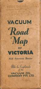 Sunshine and District Historical Society Incorporated
Map - Joseph 'Joe' Wlodarczyk Collection - Vacuum Road Map Of Victoria
... Joseph 'Joe' Wlodarczyk Collection - Vacuum Road Map Of Victoria...Map...Vacuum Oil Company...Pidd's Garage...Melbourne Road...Road travelers relied on foldable paper maps to chart their journeys, especially when venturing beyond familiar territory. ...Envelope - Pidd's Garage Melbourne Road Newport Local Dealer Olympic Tyres Vacuum Road Map of Victoria with Interstate Routes with the compliments of the Vacuum Oil Company Pty Ltd. ...Map - Vacuum Road Guide of Victoria Visit Melbourne Centenary 1934-5 Vacuum Oil Company Pty Ltd Fold out paper map in an envelope Map Joseph 'Joe' Wlodarczyk Collection - Vacuum Road Map Of Victoria ...Road travelers relied on foldable paper maps to chart their journeys, especially when venturing beyond familiar territory. Maps helped identify highways, towns, and landmarks, enabling drivers to choose efficient or scenic routes. These maps were indispensable tools for travel, planning, and exploration. This map also identified the location of Vacuum Oil Company Dealerships throughout Victoria. These paper-based maps were used before Global Positioning System "GPS" revolutionized navigation. - Envelope - Pidd's Garage Melbourne Road Newport Local Dealer Olympic Tyres Vacuum Road Map of Victoria with Interstate Routes with the compliments of the Vacuum Oil Company Pty Ltd. Map - Vacuum Road Guide of Victoria Visit Melbourne Centenary 1934-5 Vacuum Oil Company Pty Ltdmap, vacuum oil company, pidd's garage, melbourne road, newport, joseph 'joe' wlodarczyk -
Federation University Historical Collection
Map, City of Ballarat and Borough of Sebastopol Road Map
... City of Ballarat and Borough of Sebastopol Road Map...Road map of the City of Ballarat and the Borough of Sebastopol. ...Barker Library (top floor) Mount Helen goldfields ballarat sebastopol map plan ballarat shire Road map of the City of Ballarat and the Borough of Sebastopol. ...Road map of the City of Ballarat and the Borough of Sebastopol. WGS 85 Centroid 37 degrees 33 feet 56 inches south 143 degrees 51 feet 09 inches eat E-W- extent: 9 km N-S- extent: 11.5 kmballarat, sebastopol, map, plan, ballarat shire -
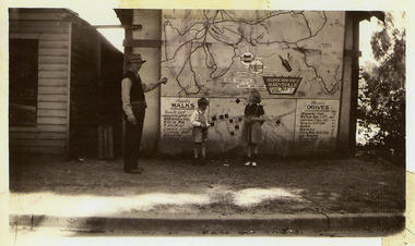 Marysville & District Historical Society
Photograph (Item) - Black and white photograph, 1949
... ...atlantic road map...A copy of a black and white photograph of an Atlantic Road Map of Marysville adhered to an unknown building in Marysville....A copy of a black and white photograph of an Atlantic Road Map of Marysville adhered to an unknown building in Marysville....A copy of a black and white photograph of an Atlantic Road Map of Marysville adhered to an unknown building in Marysville. marysville victoria maps atlantic road map A copy of a black and white photograph of an Atlantic Road Map of Marysville adhered to an unknown building in Marysville. ...A copy of a black and white photograph of an Atlantic Road Map of Marysville adhered to an unknown building in Marysville.A copy of a black and white photograph of an Atlantic Road Map of Marysville adhered to an unknown building in Marysville.marysville, victoria, maps, atlantic road map -
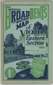 Emerald Museum & Nobelius Heritage Park
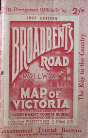
Book - Broadbent's Official Road and Railway map of Victoria, Broadbent's Official Road and Railway map of Victoria Riverina and A.C.T. Eastern Section
... Broadbent's Official Road and Railway map of Victoria... Broadbent's Official Road and Railway map of Victoria Riverina and A.C.T. ...Broadbent's Official Road and Railway map of Victoria Riverina and A.C.T. ...The book compiles a guide on how to travel across Victoria including sights to see and places to stay.Green colouring. Old browning paper.non-fictionThe book compiles a guide on how to travel across Victoria including sights to see and places to stay. -
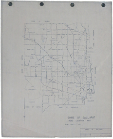 Federation University Historical Collection
Map, Shire of Ballarat Road Location Map, 1968, 05/06/2014
... Shire of Ballarat Road Location Map, 1968...White paper road location map. Scale 1 mile to 1 inch...Barker Library (top floor) Mount Helen goldfields ballarat shire of ballarat roads dowling forest lake burumbeet lake learmonth ascot windermere tourello White paper road location map. Scale 1 mile to 1 inch Shire of Ballarat Road Location Map, 1968 Map Map ...White paper road location map. Scale 1 mile to 1 inchballarat, shire of ballarat, roads, dowling forest, lake burumbeet, lake learmonth, ascot, windermere, tourello -
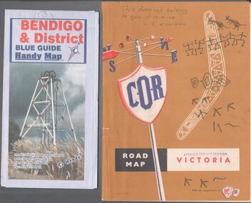 Bendigo Historical Society Inc.
Map - Road maps
... Road Map...Two road maps. On, Bendigo & District blue guide handy map the other a road map of Victoria. ...Map Road maps ...BHS CollectionTwo road maps. On, Bendigo & District blue guide handy map the other a road map of Victoria. On the back of the Bendigo map the date October 2000. On the Victoria map the words in pen "This doesn't belong to you, it is mine". L.J. Ellison and a blue stamp of Axedale service station. Aileen and John Ellison Collection.road map, victoria, bendigo -
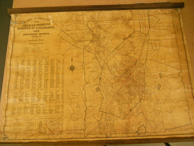 Bendigo Historical Society Inc.
Map - STREET AND ROAD MAP OF THE CITY OF BENDIGO BOROUGH OF EAGLEHAWK AND SURROUNDING DISTRICTS
... STREET AND ROAD MAP OF THE CITY OF BENDIGO BOROUGH OF EAGLEHAWK AND SURROUNDING DISTRICTS...Harry 1946." Map STREET AND ROAD MAP OF THE CITY OF BENDIGO BOROUGH OF EAGLEHAWK AND SURROUNDING DISTRICTS ...Heavy paper map with fabric backing. Timber piece attached at top, dowel attached to bottom. String in centre for hanging. Silver duct tape attached to top to secure map. Map shows streets of Bendigo and Eaglehawk. Written on map "Compiled by W.C. Harry 1946. Examined by J. Harry 1946."map, bendigo, bendigo and borough of eaglehawk -
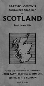 Sunshine and District Historical Society Incorporated
Map - Bartholomew's Contoured Road Map of Scotland
... Bartholomew's Contoured Road Map of Scotland...Map Bartholomew's Contoured Road Map of Scotland ...Handwritten text and arrowed line in pencil indicating location of where "Coldstream" is on the map.scotland, map -
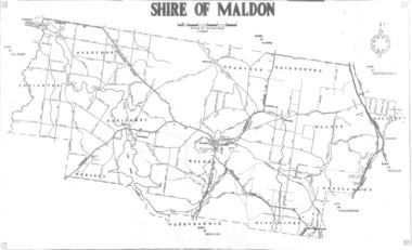 Lions Club of Maldon Inc.
Road map, Shire of Maldon, C. 1980
... Road map...Lions Club of Maldon Inc. 61-63 High St Maldon goldfields shire of maldon victoria Former Shire of Maldon Road map Shire of Maldon ...Former Shire of Maldonshire of maldon, victoria -
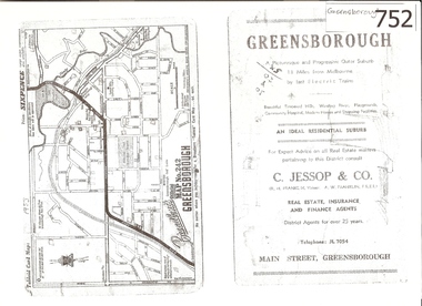 Greensborough Historical Society
Map, Broadbent's, Greensborough, 1953_
... ...map no 242...road...This road map was a part of a Broadbent's Melbourne suburban directory from 1953....A 1 page photocopy of a road map of Greensborough from 1953....Real estate advertisement greensborough c jessop broadbents map no 242 road maps 1953 Nil A 1 page photocopy of a road map of Greensborough from 1953. ...This road map was a part of a Broadbent's Melbourne suburban directory from 1953.It shows the lay out of Greensborough's streets in 1953.It also shows some different street names to those used today. It also features a C Jessop & Co. Real estate advertisementA 1 page photocopy of a road map of Greensborough from 1953.Nilgreensborough, c jessop, broadbents, map no 242, road maps, 1953 -
 Kiewa Valley Historical Society
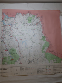
Map - Road Construction Authority 1986, Ref. Tallangatta 282008
... Map - Road Construction Authority 1986...road construction authority...map...Colored map dated 1986 titled Road Construction Authority with an update of roads in the local Shires. ...It also shows the main towns in the area and their roads. Ref. Tallangatta 282008 Map - Road Construction Authority 1986 ...Government authorities updated maps regularly.Historically of interest eg. 1. Pre dates the Alpine National Park. 2. 'Mt Beauty Estates' now known as Tawonga South. 3. Mt Niggerhead is named - It is now known as Mt Jaithmathang having been renamed in 2009.Colored map dated 1986 titled Road Construction Authority with an update of roads in the local Shires. It names places in the area and has a legion describing the rating of the roads and tracks. It also shows the main towns in the area and their roads.road construction authority, map of tallangatta area -
 Bendigo Historical Society Inc.
Document - J W SWATTON COLLECTION: MAP OF NEW SOUTH WALES
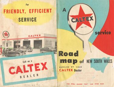
... ... Road Map of New South Wales...Two Road maps of New South Wales. C M Jones, Caltex Dealer, Golden Square, Bendigo stamped on the front. ...History House 11 Mackenzie Street Bendigo goldfields PERSON Receipts j w swatton J W Swatton Collection Road Map of New South Wales Caltex C M Jones E S Sculley Clive Barrass Two Road maps of New South Wales. ...Two Road maps of New South Wales. C M Jones, Caltex Dealer, Golden Square, Bendigo stamped on the front. Map shows Sydney Outlet Roads, City of Sydney, City of canberra, Newcastle District, Motor tours Around Sydney, Routes to Brisbane, Road Map of New South Wales. It also lists the Principal Towns with Distances from Sydney and Interstate Road Mileages including Sydney to Melbourne via Hume Highway, Prince's Highway, via Canberra & Bombala. Also Sydney to Adelaide via Hume & Sturt Highways, Sydney to Brisbane via New England Highway, Pacific Highway via Toowoomba and Sydney to Adelaide via Western, Mid-Western and Sturt Highways.person, receipts, j w swatton, j w swatton collection, road map of new south wales, caltex, c m jones, e s sculley, clive barrass -
Whitehorse Historical Society Inc.
Map, Nunawading Shire, 1892
... Covers Middleborough Road to Ringwood boundary. One map (Blackburn) from north of Whitehorse Road to Highbury Road, 2nd map (Mitcham) Bulleen to south of Canterbury Road; 3rd map Whitehorse Road to Highbury Road....One map (Blackburn) from north of Whitehorse Road to Highbury Road, 2nd map (Mitcham) Bulleen to south of Canterbury Road; 3rd map Whitehorse Road to Highbury Road....Whitehorse Historical Society Inc. 2-10 Deep Creek Road Mitcham melbourne Covers Middleborough Road to Ringwood boundary. One map (Blackburn) from north of Whitehorse Road to Highbury Road, 2nd map (Mitcham) Bulleen to south of Canterbury Road; 3rd map Whitehorse Road to Highbury Road. ...Photocopy of an enlargement of map of Shire of Nunawading showing landowners in 1892.Photocopy of an enlargement of map of Shire of Nunawading showing landowners in 1892. Covers Middleborough Road to Ringwood boundary. One map (Blackburn) from north of Whitehorse Road to Highbury Road, 2nd map (Mitcham) Bulleen to south of Canterbury Road; 3rd map Whitehorse Road to Highbury Road.Photocopy of an enlargement of map of Shire of Nunawading showing landowners in 1892. maps, shire of nunawading, blackburn, blackburn south, nunawading, forest hill, vermont, mitcham, vermont south -
 Bendigo Historical Society Inc.
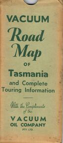
Document - BILL ASHMAN COLLECTION: VACUUM MAP OF TASMANIA
... ... Vacuum Road Map of Tasmania and Complete Touring Information...Vacuum Road Map of Tasmania and Complete Touring Information with the Compliments of the Vacuum Oil Company Pty Ltd. ...History House 11 Mackenzie Street Bendigo goldfields MAP Bill Ashman Collection - Correspondence Vacuum Road Map of Tasmania and Complete Touring Information Vacuum Oil Company Pty Ltd Vacuum Road Map of Tasmania and Complete Touring Information with the Compliments of the Vacuum Oil Company Pty Ltd. ...Vacuum Road Map of Tasmania and Complete Touring Information with the Compliments of the Vacuum Oil Company Pty Ltd. Coloured map of Tasmania with trucks, aeroplane, oil bottles and petrol bowsers in the margins. Alphabetical Index of Towns, Lakes, Mountains, Bays, Capes, etc., with key and Licensed Public Aerodromes in Tasmania and Their Location. On the back is Outlets of Hobart, Outlets of Launceston, What to See in Hobart, Beauty Spots and Tourist Information, What to See in Launceston, Vacuum Products, Traffic Hints, Super Plume or Plume, Making Sure of a Trouble-Free Trip and the front cover picture of a lady, child and a man in their car at the petrol bowser. Map folds up and is kept in a light green folder.map, bill ashman collection - correspondence, vacuum road map of tasmania and complete touring information, vacuum oil company pty ltd -
 Bendigo Historical Society Inc.
Document - BILL ASHMAN COLLECTION: VACUUM MAP OF SOUTH AUSTRALIA
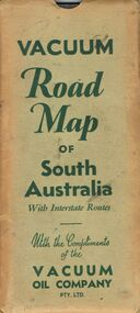
... ... Vacuum Road Map of South Australia...Vacuum Road Map of South Australia with Interstate Routes with the Compliments of the Vacuum Oil Company Pty. ...Vacuum Road Map of South Australia with Interstate Routes with the Compliments of the Vacuum Oil Company Pty. ...Vacuum Road Map of South Australia with Interstate Routes with the Compliments of the Vacuum Oil Company Pty. Ltd. Coloured map of S.A. with car, trucks, aeroplane and petrol bowsers on the map. Map only shows the Southern half of S.A. On the back is Adelaide-Melbourne Routes, Traffic Hints, Eucla to Perth, Tours Around Adelaide, Acknowledgement to the Royal Automobile Association of South Australia, Inc., Darwin-Adelaide Routes, Outlets of Adelaide, Vacuum Products, What to See in Adelaide, Super Plume Ethyl, Making Sure of a Trouble-Free Trip, and the front cover. Also folded in the map is a small map from Hancock's Garage, Kingston with routes from Melbourne to Adelaide and distances. On the back is an advertisement for Hancock's Garage and a map of Kingston. Map folded and kept in a light green cover.map, bill ashman collection - correspondence, vacuum road map of south australia, vacuum oil company pty ltd, commissioner of crown lands for south australia, royal automobile association of south australia, inc. -
 Hymettus Cottage & Garden Ballarat
Work on paper, Broadbent's Road and Rail Map of Victoria
... Broadbent's Road and Rail Map of Victoria...Hymettus Cottage & Garden Ballarat 8 Cardigan St Lake Wendouree goldfields VictoriA Map Broadbent's Broadbent's Road and Rail Map of Victoria Work on paper ...non-fictionvictoria, map, broadbent's -
 Emerald Museum & Nobelius Heritage Park
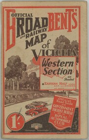
Book - Broadbent's Official Road and Railway Map of Victoria Western Section
... Broadbent's Official Road and Railway Map of Victoria Western Section...Book Broadbent's Official Road and Railway Map of Victoria Western Section ...The book was published in the 1930s - 1940s by the Broadbent's Official Road Guides Co. The book compiles a guide of how to travel across Victoria's western section and lists places to see and stay as a tourist.The item has significance as it gives insight into how tourists travelled in the early to mid 1900s across Victoria.Paperback book, paper browning. Red and black colouring on front and back. -
 Bendigo Historical Society Inc.
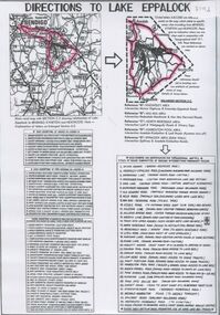
Document - Directions to Lake Eppalock with road descriptions and map
... Directions to Lake Eppalock with road descriptions and map...Document Directions to Lake Eppalock with road descriptions and map ...John Perry Collection. Laminated copy of 'Directions to Lake Eppalock'. Gives directions in relationship of Lake Eppalock to Bendigo, Kyneton and Heathcote. Undated. Gives basic descriptions of bridges on lakebed, ford crossings on lakebed and inundated dwellings on lakebed. The dam was built by the State Rivers and Water Supply Commission of Victoria. The dam wall height is 45 metres (148 ft) and the main embankment is 1,041 metres (3,415 ft) long. At 100% capacity the dam wall was designed to hold back 304,651 megalitres (6.7014×10¹⁰ imp gal; 8.0480×10¹⁰ US gal) of water. The surface area of Lake Eppalock is 3,011 hectares (7,440 acres) and the catchment area is 2,124 square kilometres (820 sq mi). The controlled spillway is capable of discharging 8,040 cubic metres per second (284,000 cu ft/s). Lake Eppalock supplies both stock and domestic water to the Campaspe irrigation district. It also serves as a water supply to Bendigo and Heathcote and, in more recent times, Ballarat. The lake is a major attraction for those engaging in watersports, with a number of tourist parks and accommodation facilities available. Permissible activities on the lake include high-speed boating, water skiing, sailing, canoeing, fishing and swimming. The lake's water levels were low for approximately eight years between 2002 and 2010 during a prolonged drought, which restricted the amount of recreational activity until rainfall in the latter half of 2010 returned the lake to 100 percent capacity. Built between 1961 and 1964, Lake Eppalock remains the only water storage on the Campaspe River system.water, dam, directions, eppalock -
Canterbury History Group
Map - Maling Road Urban Renewal Map 1972, 1972
... Maling Road Urban Renewal Map 1972...Photocopy of map of proposed urban renewal in Maling Road Canterbury 1971...Canterbury History Group 190A Canterbury Road Canterbury melbourne Canterbury Maling Road Town Planning Maps Photocopy of map of proposed urban renewal in Maling Road Canterbury 1971 Map Maling Road Urban Renewal Map 1972 ...Photocopy of map of proposed urban renewal in Maling Road Canterbury 1971canterbury, maling road, town planning, maps