Showing 21 items matching " road map of new south wales"
-
 Bendigo Historical Society Inc.
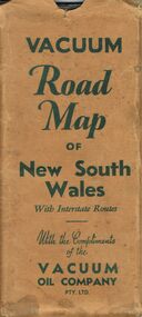
Document - BILL ASHMAN COLLECTION: VACUUM ROAD MAP OF NEW SOUTH WALES
... BILL ASHMAN COLLECTION: VACUUM ROAD MAP OF NEW SOUTH WALES... Vacuum Road Map of New South Wales...Vacuum Road Map of New South Wales with Interstate Routes with the Compliments of the Vacuum Oil Company Pty. ...History House 11 Mackenzie Street Bendigo goldfields MAP Bill Ashman Collection - Correspondence Vacuum Road Map of New South Wales Vacuum Oil Company Pty Ltd Clive Barass Vacuum Road Map of New South Wales with Interstate Routes with the Compliments of the Vacuum Oil Company Pty. ...Vacuum Road Map of New South Wales with Interstate Routes with the Compliments of the Vacuum Oil Company Pty. Ltd. Coloured map of NSW with car, trucks, aeroplane and petrol bowsers around the margin. Has a list of principal Towns and Distances from Sydney. On the back is Beauty Spots around Sydney, Traffic Hints, Sydney-Melbourne Routes, Short Tours Around Sydney, Outlets of Sydney, Canberra and Newcastle, What to See in Sydney, Vacuum Products, Making Sure of a Trouble-Free Trip, Super Plume or Plume and the front picture of the folded map which has a car with a lady, child and a man at the petrol bowser. Map folds up and has a brown card pocket to keep it in.map, bill ashman collection - correspondence, vacuum road map of new south wales, vacuum oil company pty ltd, clive barass -
 Bendigo Historical Society Inc.
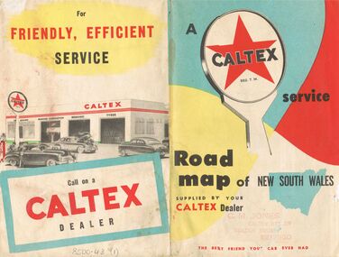
Document - J W SWATTON COLLECTION: MAP OF NEW SOUTH WALES
... ... Road Map of New South Wales...Two Road maps of New South Wales. C M Jones, Caltex Dealer, Golden Square, Bendigo stamped on the front. ...History House 11 Mackenzie Street Bendigo goldfields PERSON Receipts j w swatton J W Swatton Collection Road Map of New South Wales Caltex C M Jones E S Sculley Clive Barrass Two Road maps of New South Wales. ...Two Road maps of New South Wales. C M Jones, Caltex Dealer, Golden Square, Bendigo stamped on the front. Map shows Sydney Outlet Roads, City of Sydney, City of canberra, Newcastle District, Motor tours Around Sydney, Routes to Brisbane, Road Map of New South Wales. It also lists the Principal Towns with Distances from Sydney and Interstate Road Mileages including Sydney to Melbourne via Hume Highway, Prince's Highway, via Canberra & Bombala. Also Sydney to Adelaide via Hume & Sturt Highways, Sydney to Brisbane via New England Highway, Pacific Highway via Toowoomba and Sydney to Adelaide via Western, Mid-Western and Sturt Highways.person, receipts, j w swatton, j w swatton collection, road map of new south wales, caltex, c m jones, e s sculley, clive barrass -
 Monbulk RSL Sub Branch
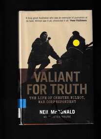
Book, Neil McDonald et al, Valiant for truth: The life of Chester Wilmot, war correspondent, 2016
... Road Monbulk yarra-valley-and-the-dandenong-ranges Chester Wilmot was a renowned Australian war correspondent, broadcaster, journalist and writer. He covered all Australian participation in World War II as well as the eventual defeat of Nazi Germany. world war 1939-1945 - journalists - biography wilmot chester 1911-1954 Valiant for the truth charts Wilmots exceptional life as he reported key events of the twentieth century. Notes, index, bibliography, maps, p.463. Valiant for truth: The life of Chester Wilmot, war correspondent Book Neil McDonald University of New South Wales ...Valiant for the truth charts Wilmots exceptional life as he reported key events of the twentieth century.Notes, index, bibliography, maps, p.463.non-fictionValiant for the truth charts Wilmots exceptional life as he reported key events of the twentieth century.world war 1939-1945 - journalists - biography, wilmot chester 1911-1954 -
 Geelong RSL Sub Branch
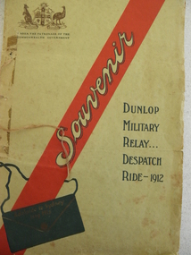
Souviner Program, No makers listed, Dunlop Military Relay ... Despatch Ride 1912, 1912
... Road Belmont geelong-and-the-bellarine-peninsula In 1912 there was a Military Relay Despatch Ride through South Australia, Victoria and New South Wales. The purpose of the ride was to deliver a despatch in the quickest possible time by road through the three states mentioned. The ride was carried out under the auspices of the Dunlop Rubber Company and involved cyclists, motor cyclists and motorists. This is an original program of the event that was carried out in 1912. The program details the list of participants, a map ...In 1912 there was a Military Relay Despatch Ride through South Australia, Victoria and New South Wales. The purpose of the ride was to deliver a despatch in the quickest possible time by road through the three states mentioned. The ride was carried out under the auspices of the Dunlop Rubber Company and involved cyclists, motor cyclists and motorists.This is an original program of the event that was carried out in 1912. The program details the list of participants, a map of the route taken and statements of appreciation from the Military and the Promoters', there is also a message of greeting from the Military Commandant, South Australia to the Military Commandant, New South Wales.A cardboard cover program with white thick pages inside.On the front cover a Coat of Arms, a red stripe with souviner written in the stripe and Dunlop Military Relay ... Despatch Ride - 1912.military relay, 1912, despatch ride, dunlop rubber company -
 Friends of St Brigids Association
Book - Letters from Irish Australia 1825-1929, O’Farrell, Patrick James. 1984. Letters from Irish Australia 1825-1929. Sydney : New South Wales University Press ; Belfast : Ulster Historical Foundation, 1984 244 p. : ill., maps ; 25 cm
... Road Crossley, 3283 O’Farrell, Patrick James. 1984. Letters from Irish Australia 1825-1929. Sydney : New South Wales University Press ; Belfast : Ulster Historical Foundation, 1984 244 p. : ill., maps ; 25 cm. ... -
Vision Australia
Administrative record (Series), Braille Writers Association of New South Wales, 1949-unknown
... Road Kooyong melbourne Annual Reports were used by institutions to provide its members and the general public with evidence of it's work undertaken during the year, acknowledge those who had contributed and to map out plans for the future. Largely written by executive committee members, the styles of annual reports altered over time with the changes and reduced costs of printers and photographers. Initially kept small and with minimum illustrations, to reduce costs, they varied over the years to have more and large images, tables and graphs, and glossy pages. Braille Writers Association of New South Wales ...Braille and Talking Book Library, 31-51 Commercial Road, South Yarra, Victoria 3141To provide information on general information on work undertaken, financial position, income and cash flow.Single volumes created annually from 1972 until 1991.Minutes of AGM, Annual Report of Directors, President's Report, financial informationbraille writers association of new south wales, corporation recordsbraille writers association of new south wales, corporation records -
 Vision Australia
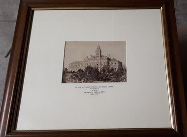
Photograph - Image, Charles Nettleton, Blind Asylum School, St Kilda Road, circa 1875
... Blind Asylum School, St Kilda Road Victoria c. 1875 Charles Nettleton 1826-1902 Spencer Scott Sandilands 546 High Street, East Preson, 3181 Melbourne, Victoria, Australia, Tel: (03) 529 8011 Fax: (03) 521 1754 33 George Street, The Rocks, 2000 Sydney, New South Wales, Australia, Tel: (02) 241 4251 Fax: (02) 2414535 Rare Prints, Antiquarian Books, Old Maps, Australiana, Antiques, Photographs, Framing c.1875 Charles Nettleton School from the Blind Original Photograph $65 Guaranteed over 100 years old...Royal Victorian Institute for the Blind Buildings Blind Asylum School, St Kilda Road Victoria c. 1875 Charles Nettleton 1826-1902 Spencer Scott Sandilands 546 High Street, East Preson, 3181 Melbourne, Victoria, Australia, Tel: (03) 529 8011 Fax: (03) 521 1754 33 George Street, The Rocks, 2000 Sydney, New South Wales, Australia, Tel: (02) 241 4251 Fax: (02) 2414535 Rare Prints, Antiquarian Books, Old Maps, Australiana, Antiques, Photographs, Framing c.1875 Charles Nettleton School from the Blind Original Photograph $65 Guaranteed over 100 years old 2 black and white images of the Guiding Light at Elanora Blind Asylum School, St Kilda Road Photograph Image Charles Nettleton ...Unsubstantiated photograph of the Asylum for the Blind in 1875. The four storey bluestone building rises above a group of trees planted in the garden. A picket and wire/string fence border the unpaved circular driveway. 2 black and white images of the Guiding Light at Elanora Blind Asylum School, St Kilda Road Victoria c. 1875 Charles Nettleton 1826-1902 Spencer Scott Sandilands 546 High Street, East Preson, 3181 Melbourne, Victoria, Australia, Tel: (03) 529 8011 Fax: (03) 521 1754 33 George Street, The Rocks, 2000 Sydney, New South Wales, Australia, Tel: (02) 241 4251 Fax: (02) 2414535 Rare Prints, Antiquarian Books, Old Maps, Australiana, Antiques, Photographs, Framing c.1875 Charles Nettleton School from the Blind Original Photograph $65 Guaranteed over 100 years oldroyal victorian institute for the blind, buildings -
Vision Australia
Administrative record (Series), Royal Blind Society of New South Wales Annual Reports, 1952-2004
... Road Kooyong melbourne Annual Reports were used by institutions to provide its members and the general public with evidence of it's work undertaken during the year, acknowledge those who had contributed and to map out plans for the future. Largely written by executive committee members, the styles of annual reports altered over time with the changes and reduced costs of printers and photographers. Initially kept small and with minimum illustrations, to reduce costs, they varied over the years to have more and large images, tables and graphs, and glossy pages. corporation records Royal Blind Society of New South Wales ...Royal Society for the Blind of New South Wales, 7 Mitchell Street, Enfield, NSW 2136To provide information on general information on work undertaken, financial position, income and cash flow.Single volumes created annually from 1952 until 2004.President's Report, Finance Report, General Overview of Services.corporation records, royal blind society of new south walescorporation records, royal blind society of new south wales -
 Wodonga & District Historical Society Inc
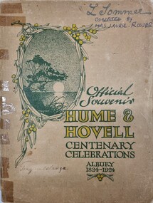
Booklet - Hume and Hovell Centenary Celebrations Booklet
... Road Bonegilla the-murray This document records the celebrations held in Albury to commemorate the centenary of the expedition of Hume & Hovell in 1824. Hume & Hovell Hume & Hovell centenary This souvenir was created as part of the celebrations to commemorate the journey of Hume and Hovell from New South Wales (Near Yass) to Port Phillip Bay, passing through the site of modern day Albury and Northeast Victoria. Official Souvenir / Hume & Hovell / Centenary Celebrations / Albury 1824 - 1924 A small booklet printed for celebrations to commemorate the centenary of the journey of Hume and Hovell, including maps ...This souvenir was created as part of the celebrations to commemorate the journey of Hume and Hovell from New South Wales (Near Yass) to Port Phillip Bay, passing through the site of modern day Albury and Northeast Victoria.A small booklet printed for celebrations to commemorate the centenary of the journey of Hume and Hovell, including maps and advertising.fictionThis souvenir was created as part of the celebrations to commemorate the journey of Hume and Hovell from New South Wales (Near Yass) to Port Phillip Bay, passing through the site of modern day Albury and Northeast Victoria.hume & hovell, hume & hovell centenary -
 Wodonga & District Historical Society Inc
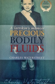
Book - Precious Bodily Fluids: A Larrikan's Memoir, Charles Waterstreet, 1998
... Wodonga & District Historical Society Inc Hut 97, Bonegilla Migrant Experience, 132 Bonegilla Road Bonegilla the-murray This novel shares reminiscence of childhood in the Albury Wodonga district in the 1960s Albury NSW Social Conditions Albury 1960s This publication tells the story of the battle to introduce fluoridation to eh water supply of Albury in New South Wales. The events are described through the eyes of the author, Charles Wallstreet wo was a11 years old when the battle raged. A publication of 262 pages. Soft cover includes images with the synopsis published on the back. The inside cover includes a map ...This publication tells the story of the battle to introduce fluoridation to eh water supply of Albury in New South Wales. The events are described through the eyes of the author, Charles Wallstreet wo was a11 years old when the battle raged.A publication of 262 pages. Soft cover includes images with the synopsis published on the back. The inside cover includes a map of the Albury district .non-fictionThis publication tells the story of the battle to introduce fluoridation to eh water supply of Albury in New South Wales. The events are described through the eyes of the author, Charles Wallstreet wo was a11 years old when the battle raged. albury nsw social conditions, albury 1960s -
 Wodonga & District Historical Society Inc
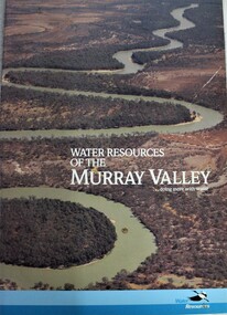
Book - Water Resources of the Murray Valley, Department of Water Resources New South Wales, 1992
... Wodonga & District Historical Society Inc Hut 97, Bonegilla Migrant Experience, 132 Bonegilla Road Bonegilla the-murray water resources development water quality management -- murray river region murray river A study of the Murray River water management and resources, including illustrations and maps. Water Resources of the Murray Valley Book Water Resources of the Murray Valley Department of Water Resources New South Wales ...A study of the Murray River water management and resources, including illustrations and maps.non-fictionA study of the Murray River water management and resources, including illustrations and maps.water resources development, water quality management -- murray river region, murray river -
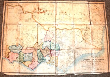 Wodonga & District Historical Society Inc
Map - Tulloch & Brown's Map of the Colony of Victoria, Tulloch & Brown, 1856
... At bottom right hand section of map: Tulloch & Brown's map of the Colony of Victoria : comprising part of New South Wales, the boundaries, counties, also seaport & inland townships, the gold fields with the latest discoveries, roads, tracks, &c. ...Tulloch and Brown maps Rare maps Victoria Victorian cartography At bottom right hand section of map: Tulloch & Brown's map of the Colony of Victoria : comprising part of New South Wales, the boundaries, counties, also seaport & inland townships, the gold fields with the latest discoveries, roads, tracks, &c. ...The map was created by Tulloch and Brown. David Tulloch was one of the earliest engravers and lithographers in the state of Victoria. He arrived in Melbourne from Greenock, Scotland, on 3 January 1849. Following the discovery of gold Tulloch went to the Victorian goldfields in 1851, commissioned to make sketches of the diggers and the diggings for Ham’s Illustrated Australian Magazine. In November 1852 Tulloch set up in business as engraver, draughtsman, copperplate printer and lithographer. Tulloch took a map engraver, James Davie Brown, into partnership in March 1853; the several maps and specimens of commercial engraving they showed at the 1854 Melbourne Exhibition were awarded a bronze medal. That year Tulloch and Brown also received a silver medal at the Victorian Industrial Exhibition. The partnership was dissolved towards the end of 1856.This is a very early map of the Colony of Victoria including Belvoir (now know as Wodonga).A foldable map mounted on linen and with a board cover. It records the Colony of Victoria according to Surveyor's Records revised in 1857. Areas of the map are shaded to highlight different counties.At bottom right hand section of map: Tulloch & Brown's map of the Colony of Victoria : comprising part of New South Wales, the boundaries, counties, also seaport & inland townships, the gold fields with the latest discoveries, roads, tracks, &c. &c. / compiled from drawings in the Survey Office and correctly revised till 1857. Respectfully dedicated by Permission, to the Honorable Captain Andrew Clarke R.E. Surveyor General of Victoria by His Obediant Servants Tulloch & Brown, Engravers & Publishers, Melbourne". At bottom right below border : Published as the Act directs by the Proprietors, Melbourne, 1st Feb. 1856. tulloch and brown maps, rare maps victoria, victorian cartography -
 Wodonga & District Historical Society Inc
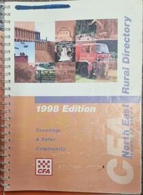
Book - North East Rural Directory 1998
... New South Wales border following the Murray River. It also includes Falls Creek and Mount Hotham. On Cover CFA North East Rural Directory Regions 23 and 24 1998 Edition Creating a Safer Community CFA Logo A spiral bound volume including colour topographic maps and illustrations of North East Victoria. The cover features a collage of colour photo of North East Victoria including a CFA firefighter in a truck with members of his family beside it. The book also features a key map, explanation of map references and symbols, localities index. Alphabetical road ...The CFA North East Rural Directory for Regions 23 and 24 was designed to assist fire brigades and other emergency services in responding to calls in the North East region of Victoria. Its purpose was to minimize response times to emergency situations by providing accurate and detailed information about all of the localities in the regions. District 23 is based at Wangaratta and Extends as far south as Woods Point. District 24 is centred in Wodonga and extends past Corryong to the New South Wales border following the Murray River. It also includes Falls Creek and Mount Hotham.A spiral bound volume including colour topographic maps and illustrations of North East Victoria. The cover features a collage of colour photo of North East Victoria including a CFA firefighter in a truck with members of his family beside it. The book also features a key map, explanation of map references and symbols, localities index. Alphabetical road indexes for Wodonga, Albury, Wangaratta and Benalla as well as township maps and alphabetical road indexes for smaller communities are included.The CFA North East Rural Directory for Regions 23 and 24 was designed to assist fire brigades and other emergency services in responding to calls in the North East region of Victoria. Its purpose was to minimize response times to emergency situations by providing accurate and detailed information about all of the localities in the regions. District 23 is based at Wangaratta and Extends as far south as Woods Point. District 24 is centred in Wodonga and extends past Corryong to the New South Wales border following the Murray River. It also includes Falls Creek and Mount Hotham.emergency management north east victoria, cfa region 24, cfa wodonga, cfa region 23 -
 Wodonga & District Historical Society Inc
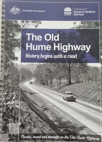
Book - The Old Hume Highway - History begins with a Road, 2014
... New South Wales were bypassed and often forgotten by passing commuters in a rush to reach their destination. This publication includes maps and information about the sites and landmarks in these towns. It encourages travellers to venture of the modern highway and rediscover the Old Hume Highway and the stories it holds about out past. A spiral bound volume of 122 pages including maps, photographs and illustrations prepared as a travel guide to the Old Hume Highway. It includes a Foreword by Peter FitzSimons. The Old Hume Highway - History begins with a Road ...The Hume Highway was officially named in 1928, when both the New South Wales and Victorian governments agreed to give the unified inland route between Sydney and Melbourne the name, honouring explorer Hamilton Hume who, with William Hovell, first found the overland path in 1824. Much of the original highway followed their overland route wherever the landscape allowed. The road connected many small communities and rural properties, although in many parts was narrow and unsurfaced. Over the following years alterations and some deviations occurred with changing transport needs and heavier traffic loads. One of these deviations was completed in 1933 at Table Top north of Albury between Ettamogah and Mullengandra due to the construction of the Hume Weir which flooded the existing highway. Gradually sections of the road were converted to a dual carriageway. In 1961 the first modern freeway-standard, four-lane section was completed in Victoria at Craigieburn. The Hume Highway was also rerouted in Albury to avoid the town centre. Many major bypasses and duplications in New South Wales were completed throughout the 1980s and 1990s. In 1994 the last section of the Hume Highway in Victoria was duplicated with the completion of the Wangaratta bypass. The Albury-Wodonga bypass was opened in 2007 and in 2013 the final section, the Holbrook Bypass in NSW, was opened to traffic on August 7, completing the full Sydney-Melbourne dual carriageway link. In the course of this gigantic engineering achievement, many small, historic towns throughout Victoria and New South Wales were bypassed and often forgotten by passing commuters in a rush to reach their destination. This publication includes maps and information about the sites and landmarks in these towns. It encourages travellers to venture of the modern highway and rediscover the Old Hume Highway and the stories it holds about out past.A spiral bound volume of 122 pages including maps, photographs and illustrations prepared as a travel guide to the Old Hume Highway. It includes a Foreword by Peter FitzSimons.The Hume Highway was officially named in 1928, when both the New South Wales and Victorian governments agreed to give the unified inland route between Sydney and Melbourne the name, honouring explorer Hamilton Hume who, with William Hovell, first found the overland path in 1824. Much of the original highway followed their overland route wherever the landscape allowed. The road connected many small communities and rural properties, although in many parts was narrow and unsurfaced. Over the following years alterations and some deviations occurred with changing transport needs and heavier traffic loads. One of these deviations was completed in 1933 at Table Top north of Albury between Ettamogah and Mullengandra due to the construction of the Hume Weir which flooded the existing highway. Gradually sections of the road were converted to a dual carriageway. In 1961 the first modern freeway-standard, four-lane section was completed in Victoria at Craigieburn. The Hume Highway was also rerouted in Albury to avoid the town centre. Many major bypasses and duplications in New South Wales were completed throughout the 1980s and 1990s. In 1994 the last section of the Hume Highway in Victoria was duplicated with the completion of the Wangaratta bypass. The Albury-Wodonga bypass was opened in 2007 and in 2013 the final section, the Holbrook Bypass in NSW, was opened to traffic on August 7, completing the full Sydney-Melbourne dual carriageway link. In the course of this gigantic engineering achievement, many small, historic towns throughout Victoria and New South Wales were bypassed and often forgotten by passing commuters in a rush to reach their destination. This publication includes maps and information about the sites and landmarks in these towns. It encourages travellers to venture of the modern highway and rediscover the Old Hume Highway and the stories it holds about out past.old hume highway, hume highway, travel guide hume highway, \ -
 National Wool Museum
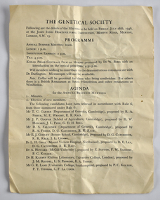
Document - The Genetical Society, 1946
... New South Wales Graziers Association, Mr J. W. Allen Front: THE GENETICAL SOCIETY / Following are the details of the MEETING to be held on FRIDAY, JULY 26th, 1946, / at the JOHN INNES HORTICULTURAL INSTITUTION, MOSTYN ROAD, MERTON, / LONDON, S.W. 19. Four page folded leaflet outlining the agenda for a business meeting. A map ...This item is associated with the Secretary of the New South Wales Graziers Association, Mr J. W. AllenFour page folded leaflet outlining the agenda for a business meeting. A map is printed on the back page.Front: THE GENETICAL SOCIETY / Following are the details of the MEETING to be held on FRIDAY, JULY 26th, 1946, / at the JOHN INNES HORTICULTURAL INSTITUTION, MOSTYN ROAD, MERTON, / LONDON, S.W. 19. -
 Whitehorse Historical Society Inc.
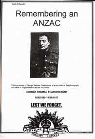
Report, George Redman Featherstone, 1/06/1997
... Road, Mitcham but he enlisted in New South Wales. He trained in England and was killed during the third Battle of Ypres. Details are given of his military career and of the battle. Photographs and information about the Bedford House Cemetery at Zillebeke in Belgium where he is buried. Information is given about his family. Photographs. Maps...Road, Mitcham but he enlisted in New South Wales. He trained in England and was killed during the third Battle of Ypres. Details are given of his military career and of the battle. Photographs and information about the Bedford House Cemetery at Zillebeke in Belgium where he is buried. Information is given about his family. Photographs. Maps ...Photocopy of a school assignment. Information is given on a number of War Memorials and an investigation into George Redman Featherstone whose name is on the Mitcham War Memorial. His mother lived at 'Redmoyne' Whitehorse Road, Mitcham but he enlisted in New South Wales. He trained in England and was killed during the third Battle of Ypres. Details are given of his military career and of the battle. Photographs and information about the Bedford House Cemetery at Zillebeke in Belgium where he is buried. Information is given about his family. Photographs. Maps. Approx 22 pages Author of assignment: Emily Schneiderfeatherstone, george redman;, world war 1914-1918. battle of ypres, war memorials -
Whitehorse Historical Society Inc.
Map, Railway map of Victoria, 1912
... Whitehorse Historical Society Inc. 2-10 Deep Creek Road Mitcham melbourne maps railways Detailed map of railways in Victoria including adjacent areas of New South Wales. ...Detailed map of railways in Victoria including adjacent areas of New South Wales.Detailed map of railways in Victoria including adjacent areas of New South Wales. Also shows 'principal coach routes'. On verso map of suburban lines with eastern line as far as Croydon and Bayswater. key numbers on map linked to pages of a timetable.Detailed map of railways in Victoria including adjacent areas of New South Wales.maps, railways -
 Flagstaff Hill Maritime Museum and Village
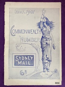
Newspaper - Magazine Supplement, Jan 1.1901 Commonwealth Number Sydney Mail, Jan 1 1901
... Flagstaff Hill Maritime Museum and Village Great Ocean Road Shipwreck Coast Commonwealth Federation Jan 1 – 1901 Sydney Mail Commonwealth Number Melbourne 1901 Sydney 1901 Brisbane 1901 Adelaide 1901 Capital city maps 1901 Victoria Tasmania New South Wales Queensland South Australia Western Australia The magazine supplement, put out by the Sydney Mail, is a celebration issue for the new Commonwealth of Australia. ...This magazine supplement celebrates a most significant event in the history of Australia – Federation. Australia became a nation on 1 January 1901 when 6 British colonies – New South Wales, Victoria, Queensland, South Australia, Western Australia and Tasmania – united to form the Commonwealth of Australia. Prior to this time each colony acted like a separate country which caused inefficiencies and problems as the population grew. Sir Henry Parkes began the movement towards a Commonwealth. Elected delegates worked through a series of processes to finally present a constitution that would unite the colonies and give Australia a federal system of government. The people of the colonies approved the constitution in a series of referendums. The Commonwealth of Australia was declared on 1 January 1901 at a ceremony held in Centennial Park in Sydney. During the ceremony, the first Governor-General, Lord Hopetoun, was sworn-in and Australia's first Prime Minister, Edmund Barton, and federal ministers took the oath of office. The first federal elections for the new Australian Parliament were held on 29 and 30 March 1901. The first Parliament of the Commonwealth of Australia was opened at noon on 9 May 1901 by the Duke of Cornwall and York (later King George V). For more information see https://peo.gov.au/understand-our-parliament/history-of-parliament/federation/the-federation-of-australia The item is significant as both a written and pictorial document pertaining to the formation of the Commonwealth of Australia.The magazine supplement, put out by the Sydney Mail, is a celebration issue for the new Commonwealth of Australia. It provides written background on the formation of the Commonwealth, maps of Melbourne, Sydney, Brisbane and Adelaide and pictorial photos of each state and it’s capital city. It includes the portraits of: delegates to the National Australasian Convention, 1891; delegates to the Federal Convention, Sydney, 1897; delegates sent to England to see the Commonwealth Bill through the House of Commons; the Earl of Hopetoun, first Governor-General of Australia and Queen Victoria. Being a magazine supplement, it has pages at the beginning and end devoted to advertisements for a variety of goods ranging from jewellery to farm machinery. flagstaff hill maritime museum and village, great ocean road, shipwreck coast, commonwealth, federation, jan 1 – 1901, sydney mail, commonwealth number, melbourne 1901, sydney 1901, brisbane 1901, adelaide 1901, capital city maps 1901, victoria, tasmania, new south wales, queensland, south australia, western australia -
Lakes Entrance Historical Society
Map - County of Croajingolong, Department Lands and Survey, 1966
... Waterways Roads Settlement Shows New South Wales Border, Wangarabell, Maramingo, Wau Wauka West, Princes Highway, Maramingo Creek, Sandy Waterhole Creek Camp Res. Map ...Shows New South Wales Border, Wangarabell, Maramingo, Wau Wauka West, Princes Highway, Maramingo Creek, Sandy Waterhole Creek Camp Res.waterways, roads, settlement -
 Bendigo Historical Society Inc.
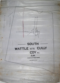
Map - South Wattle Gully Mine Chewton
... The New Prince of Wales Mine was located Eaglehawk, nearest intersection Hopkins Road and Williams Road. The Old Prince of Wales Mine was nearby. Margaret Roberts gold South Wattle Gully Chewton lease holding Hand drawn map of South Wattle Gully lease with mine working indicated on map. ...The New Prince of Wales Mine was located Eaglehawk, nearest intersection Hopkins Road and Williams Road. The Old Prince of Wales Mine was nearby. Hand drawn map of South Wattle Gully lease with mine working indicated on map. Written on map: 'Places and reports, South Wattle Gully, W. Edwards, July 1945' Plan forms part of the Margaret Roberts Collection of mining records. margaret roberts, gold, south wattle gully, chewton, lease holding -
 Victorian Railway History Library
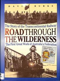
Book, Burke, David, Road Through The Wilderness: The Story of the Transcontinental Railway, 1991
... maps, p.280. Road Through The Wilderness: The Story of the Transcontinental Railway Book Burke, David New South Wales University Press ...A history of the building of the Transcontinental railway from Port Augusta to Kalgoorlie, the first great work of Australia's federation.index, ill, maps, p.280.A history of the building of the Transcontinental railway from Port Augusta to Kalgoorlie, the first great work of Australia's federation.railway construction - australia, trans-australian railway - history