Showing 5334 items matching " road signs"
-
 Whitehorse Historical Society Inc.
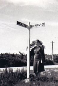
Photograph, Road signs - No roads
... Road signs - No roads...Black and white photograph of road signs in Rooks Road. Note spelling of Rookes which is incorrect and Henry Street which no longer exists. ...It is presumed that it pointed to a street which lost its identity with the development of the Migrant Hostel Road signs - No roads Photograph Photograph ...Sent to a parishioner at Christ Church Mitcham, by Phyllis Grant who lived at the Migrant Hostel in Mitcham in 1952-54, where her husband did development work under the P.M.G.Black and white photograph of road signs in Rooks Road. Note spelling of Rookes which is incorrect and Henry Street which no longer exists. It is presumed that it pointed to a street which lost its identity with the development of the Migrant Hostelrooks road mitcham -
 Whitehorse Historical Society Inc.
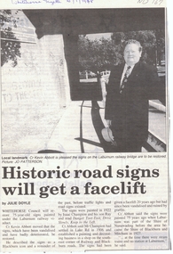
Article, Historic road signs will get a facelift, 1/01/1998 12:00:00 AM
... Historic road signs will get a facelift...The signs which have been vandalised and have badly deteriorated have been described as a Blackburn icon and a reminder of the past before traffic lights and road signs existed....The signs which have been vandalised and have badly deteriorated have been described as a Blackburn icon and a reminder of the past before traffic lights and road signs existed. Historic road signs will get a facelift Article Article ...Whitehorse Council will restore 75 year old signs painted under the Laburnum railway viaduct.Article from Whitehorse Gazette 21/1/1998 informing that Whitehorse Council will restore 75 year old signs painted under the Laburnum railway viaduct. The signs which have been vandalised and have badly deteriorated have been described as a Blackburn icon and a reminder of the past before traffic lights and road signs existed.Whitehorse Council will restore 75 year old signs painted under the Laburnum railway viaduct.city of whitehorse, abbott, kevin, champion, isaac, ray, shire of blackburn and mitcham, shire of nunawading -
 Moorabbin Air Museum
Magazine (Item) - ecafe conference, metric road signs, Transport australia
... ecafe conference, metric road signs, ...Moorabbin Air Museum Moorabbin Airport 12 First Street Moorabbin melbourne Transport australia Magazine ecafe conference, metric road signs, ... -
 Greensborough Historical Society
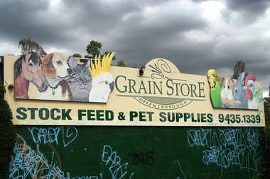
Photograph - Digital Image, Marilyn Smith, Greensborough Grain Store, 183 Para Road. Signs, 06/11/2017
... Greensborough Grain Store, 183 Para Road. Signs....Greensborough Historical Society 34A Glenauburn Road Lower Plenty Lower Plenty melbourne This photograph shows signage at 183 Para Road when the building was used for Greensborough Grain Store. greensborough grain store para road greensborough Digital copy of colour photograph Greensborough Grain Store, 183 Para Road. Signs. Photograph - Digital Image Marilyn Smith ...This photograph shows signage at 183 Para Road when the building was used for Greensborough Grain Store.Digital copy of colour photographgreensborough grain store, para road greensborough -
 Musculoskeletal Health Australia (now held by the Glen Eira Historical Society)
Photograph - Street View, XX/04/1999
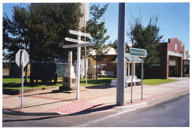
... ... road signs...A larger road sign indicates the route to the town of Mildura. ...COL photo of some directional road signs, a cenotaph, and a wooden bench with an overhead shelter on a paved area next to a building. ...A larger road sign indicates the route to the town of Mildura. ...In April 1999, Arthritis Foundation of Victoria staff travelled to Merbein, Sea Lake, and Mildura during National Arthritis Week (NAW). These visits were conceived as part of the Rural Access Project. This photo depicts a street view of a cenotaph, a covered wooden bench, and some directional road signs in Sea Lake, on route to Mildura. The cenotaph is dedicated to the memory of Trooper John Kiley (of the Victorian Imperial Battalion Bushmen, D Squardon). The wooden bench commemorates Councillor James Mudge. Both are located on Horace St (Calder Hwy), on the corner of Best St, Sea Lake. In the foreground, there is a directional road sign indicating 'CALDER HIGHWAY' and directions to various nearby towns. A larger road sign indicates the route to the town of Mildura. At that time, the Sea Lake District War Memorial had not yet been erected, but it now stands between the cenotaph and the wooden bench. The Sea Lake Visitor Information Centre is currently located on the property next door.COL photo of some directional road signs, a cenotaph, and a wooden bench with an overhead shelter on a paved area next to a building. In the foreground, one directional sign indicates 'CALDER HIGHWAY' and directions to various locations nearby, such as: 77 WYCHEPROOF; OUYEN (partially obscured); 33 LASCELLES; and SWAN HILL 77. A larger green directional sign indicates Route A79 to the town of Mildura.arthritis foundation of victoria, afv, rural access project, outreach, street signs, road signs, directional signs, war memorial, cenotaph, trooper john kiley, commemorative bench, cr james mudge, horace st, best st, sea lake, 1999 -
 National Vietnam Veterans Museum (NVVM)
Artwork, other - Painting, on velvet
... He is holding a road sign. "Tobey" on his right pocket....On helmet: FAID-V ( written in pen) . On road sign: HQ69th Sig B.N. VIETNAM printed in white on top of disc....He is holding a road sign. "Tobey" on his right pocket. Artwork, other Painting, on velvet ...Round black velvet disc with caricature-style image of a soldier in US Army battle dress with a rifle over his left shoulder painted on it . Flags of America, Vietnam and Korea are in the background. He is holding a road sign. "Tobey" on his right pocket.On helmet: FAID-V ( written in pen) . On road sign: HQ69th Sig B.N. VIETNAM printed in white on top of disc.plaque, america, craft, art, souvenir, us soldier -
 Musculoskeletal Health Australia (now held by the Glen Eira Historical Society)
Photograph - Objects, 2003
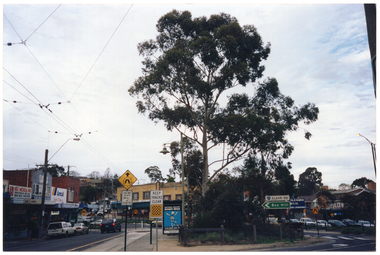
... ... road traffic signs...In the foreground, there are several road traffic signs. Around and behind the bus shelter, there are various retail stores....In the foreground, there are several road traffic signs. Around and behind the bus shelter, there are various retail stores. ...This photo depicts a 'National Healthy Bones Week' promotional billboard in situ on a bus shelter. The bus shelter is located at the Elgar and Riversdale Rds intersection, in Burwood.COL photo of a large advertisement on the side of a bus shelter. In the foreground, there are several road traffic signs. Around and behind the bus shelter, there are various retail stores.arthritis foundation of victoria, afv, osteoporosis victoria, ov, national healthy bones week, nhbw, advertisement, promotion, billboard, poster, bus shelter, bus stop, shops, retails stores, road traffic signs, street signs, 2003 -
 Canterbury History Group
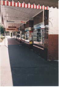
Photograph - Street view looking north up Maling Road including the shop signs of Brittany Cake Shop at No. 114, Milton's at No. 116 and Simple Solutions at No.118, Jan Pigot, 27/03/1993 12:00:00 AM
... Street view looking north up Maling Road including the shop signs of Brittany Cake Shop at No. 114, Milton's at No. 116 and Simple Solutions at No.118....Canterbury Maling Road Shops Wunderlite pressed metal ceilings Street Signs Photograph Street view looking north up Maling Road including the shop signs of Brittany Cake Shop at No. 114, Milton's at No. 116 and Simple Solutions at No.118. ...canterbury, maling road, shops, wunderlite pressed metal ceilings, street signs -
 Bendigo Historical Society Inc.
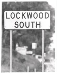
Photograph - BENDIGO ADVERTISER COLLECTION: ROAD SIGN OF LOCKWOOD SOUTH, 10/08/1993
... BENDIGO ADVERTISER COLLECTION: ROAD SIGN OF LOCKWOOD SOUTH...Road sign of Lockwood South....History House 11 Mackenzie Street Bendigo goldfields REGION Small towns Lockwood South Bill Hawkins Road sign of Lockwood South. Photograph BENDIGO ADVERTISER COLLECTION: ROAD SIGN OF LOCKWOOD SOUTH ...Road sign of Lockwood South.Bill Hawkinsregion, small towns, lockwood south -
 Vision Australia
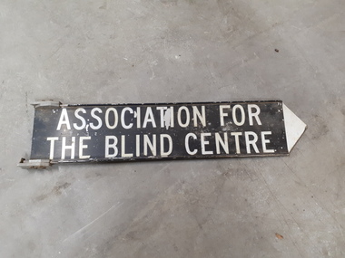
Sign - Image, Street sign for the Association for the Blind
... Black and white road sign...Vision Australia 454 Glenferrie Road Kooyong melbourne A metal street sign with a black background and white writing and a white pointing tip at the end, indicating which direction the Association for the Blind was located. association for the blind Nameplates Association for the Blind Centre Black and white road sign Street sign for the Association for the Blind Sign Image ...A metal street sign with a black background and white writing and a white pointing tip at the end, indicating which direction the Association for the Blind was located.Black and white road signAssociation for the Blind Centreassociation for the blind, nameplates -
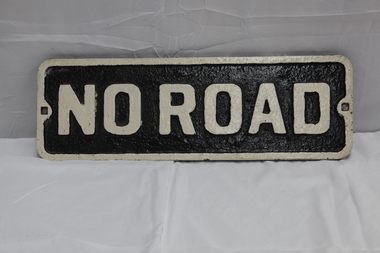 Puffing Billy Railway
No Road - End of platform sign
... No Road - End of platform sign......no road sign...Historic - Railway - No Road Plate Sign ...No Road Plate Sign Long rectangular plate that has been painted black and white with the words "no road" written across it. made of cast metal...Puffing Billy Railway 1 old monbulk road Belgrave yarra-valley-and-the-dandenong-ranges Historic - Railway - No Road Plate Sign Historic - Railway - No Road Plate Sign puffing billy sign plate no road sign "No Road" No Road Plate Sign Long rectangular plate that has been painted black and white with the words "no road" written across it. made of cast metal No Road - End of platform sign ...Historic - Railway - No Road Plate Sign Historic - Railway - No Road Plate Sign No Road Plate Sign Long rectangular plate that has been painted black and white with the words "no road" written across it. made of cast metal"No Road"puffing billy, sign, plate, no road sign -
 Falls Creek Historical Society
Poster - Kangaroo Hoppet 2011
... A Kangaroo Hoppet road sign is on the left. The page border is yellow. ...At the top: Kangaroo HOPPET 21 Australia's PREMIER X-COUNTRY SKI RACE On the road sign: KANGAROO HOPPET 42km Beneath the image 27th August 2011/ 42KM 21KM 7KM Below the line of logos: Ph. 03 5754 1045 / [email protected] www.hoppet.com.au Across the bottom in larger cursive text www.hoppet.com.au...A Kangaroo Hoppet road sign is on the left. The page border is yellow. ...The Kangaroo Hoppet is Australia’s premier long distance cross country ski race, and a member of the Worldloppet series of international cross country ski events. After running the event for 10 years, it was decided they should become part of the Worldloppet series of marathon ski races. Representatives from the Birkebeiner Nordic Ski Club and the Australian Ski Federation attended the Worldloppet Annual Meeting in Finland in June 1990 to put the case for the acceptance of an Australian event into the Worldloppet series. Before being admitted, they had to demonstrate that the Birkebeiner Club could run a world class event, so three months later in August 1990 a 42km event named the Australian International Ski Marathon was held at Falls Creek together with a 21km Birkebeiner race and a 7km event called the Birkebeiner Lite. The event was approved by delegates from USA, Norway and Austria, in 1991 Australia became the 12th member of Worldloppet, with the condition that there had to be a name change. After some late night discussion allegedly involving red wine from North East Victoria the main event became the 42km Kangaroo Hoppet, with the minor events being the 21km Australian Birkebeiner, and 7km Joey Hoppet. In the winter of 1991, the first Kangaroo Hoppet was held. It was a great success and has been a regular fixture on the international ski calendar ever since. It features the main 42km event as well as a 21km event and a 7km event. The Hoppet brings the Australian snowfields to an international audience. In 2011 the Men's Winner was Petr Novak from the Czech Republic in a time of 1:16:04. The winner of the Women's event was Esther Bottomley of Australia in a time of 1:42:22. Due to lack of snow, the course had to be relocated to the Mt McKay area at the top of the ski resort. The 42km Hoppet course was shortened to 30km.This poster is significant because it documents an event which brings international attention to Falls Creek and the surrounding region.A poster featuring a group of competitors from a previous Hoppet event. A Kangaroo Hoppet road sign is on the left. The page border is yellow. Logos of AGL, Falls Creek All Season Alpine Resort, Alpine Shire, Tourism Victoria, Parks Victoria and the Birkebeiner Nordic Ski Club are across the bottom of the poster.At the top: Kangaroo HOPPET 21 Australia's PREMIER X-COUNTRY SKI RACE On the road sign: KANGAROO HOPPET 42km Beneath the image 27th August 2011/ 42KM 21KM 7KM Below the line of logos: Ph. 03 5754 1045 / [email protected] www.hoppet.com.au Across the bottom in larger cursive text www.hoppet.com.aukangaroo hoppet, worldloppet events, falls creek, mt. beauty -
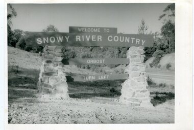 Orbost & District Historical Society
black and white photographs, second half 20th century
... photographs-Orbost Orbost-township-entry Salisbury-Street-trees town-entry road-signs-Orbost...Three black / white photographs. 3277.1 is a sign on stone pillars at the top of a hill - "WELCOME TO SNOWY RIVER COUNTRY ORBOST TURN LEFT". 3277.2 shows a road leading into a town. ...Orbost & District Historical Society Ruskin Street Orbost gippsland These photographs are pictorial records of the signs at the Orbost town entry points. photographs-Orbost Orbost-township-entry Salisbury-Street-trees town-entry road-signs-Orbost 3277.1 on back - "WELCOME TO SNOWY RIVER COUNTRY - ORBOST sign - Princes Highway - Newmerella" 3277.2 on back - "East Gippsland Shire Sign on eastern approach to ORBOST., in Salisbury Street, near Orbost Secondary College" 3277.3 on back - "Tree planting in Salisbury St, Orbost in front of Orbost High School looking west towards Orbost township" Three black / white photographs. 3277.1 is a sign on stone pillars at the top of a hill - "WELCOME TO SNOWY RIVER COUNTRY ORBOST TURN LEFT". 3277.2 shows a road leading into a town. ...These photographs are pictorial records of the signs at the Orbost town entry points.Three black / white photographs. 3277.1 is a sign on stone pillars at the top of a hill - "WELCOME TO SNOWY RIVER COUNTRY ORBOST TURN LEFT". 3277.2 shows a road leading into a town. There is a sign on the left - "ORBOST" and a service station on the right. 3277.3 shows a row of newly planted trees between a road and a school.3277.1 on back - "WELCOME TO SNOWY RIVER COUNTRY - ORBOST sign - Princes Highway - Newmerella" 3277.2 on back - "East Gippsland Shire Sign on eastern approach to ORBOST., in Salisbury Street, near Orbost Secondary College" 3277.3 on back - "Tree planting in Salisbury St, Orbost in front of Orbost High School looking west towards Orbost township"photographs-orbost orbost-township-entry salisbury-street-trees town-entry road-signs-orbost -
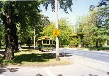
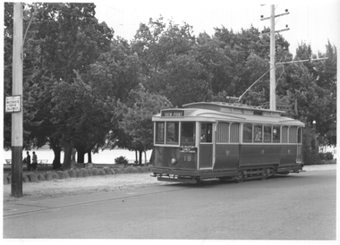 Ballarat Tramway Museum
Photograph - Ballarat tram 18 - Lake View, Ken Winney, 12/1949
... ...road signs...Tramcars tram 18 Wendouree Parade Lake View road signs "No. 18 at View Point terminus, note supplementary sing re ferry connection across Lake Wendouree, Ballarat, 12/1949, I K Winney" Black and white photograph with photographers details on rear. ...The photograph shows SEC Ballarat tram No. 18 in Wendouree Parade at a location opposite the View Point Hotel. The "gazebo" at this location can be seen behind the tram. The tram has the destination of View Point and an auxiliary sign of "Lake View Point Only - connect with launches". On the left side of the photo is a highway advisory sign "Motorists Drive Slowly" Photo by I K Winney of Sydney, 12/1949.Yields information about tram 18 and the Lake View route.Black and white photograph with photographers details on rear."No. 18 at View Point terminus, note supplementary sing re ferry connection across Lake Wendouree, Ballarat, 12/1949, I K Winney"tramcars, tram 18, wendouree parade, lake view, road signs -
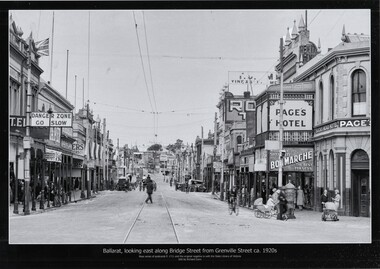 Ballarat Tramway Museum
Photograph - Black & White copy photograph, Rose Stereograph Co, "Ballarat looking east along Bridge St from Grenville St c1920s"
... ...road signs...Has in the view a number of road signs, shops, Super Spirit, Shell, Junction Service Station, motor vehicles, cyclists, Bon Marche, ladies with prams, a post box and Page's Bucks Head Hotel. ...Original photograph by Rose Series Postcard P1711 with the original image held by the State Library of Victoria. Edited by Richard Conn. Purchased by the Museum.Provides information about the appearance of Bridge St during the 1920's, shows the tram tracks and overhead. Has in the view a number of road signs, shops, Super Spirit, Shell, Junction Service Station, motor vehicles, cyclists, Bon Marche, ladies with prams, a post box and Page's Bucks Head Hotel.Black & White copy photograph view A4 size, titled "Ballarat looking east along Bridge St from Grenville St c1920s", from a Rose Series Postcard, P1711. Original image held by the State Library of Victoria.ballarat, grenville st, bucks head hotel, bridge st, road signs, bon marche, tramways -
 Ballarat Tramway Museum
Photograph - Colour Photograph/s, Earl Ewers, 1994
... ... Road Signs...The "Caution Tram Bothways" sign on the pole adjacent to Windmill Drive had recently been positioned, following donation of the signs from St. Georges Road by the City of Northcote. ...Ballarat Tramway Museum South Gardens Reserve Wendouree Parade Ballarat Ballarat goldfields Windmill Drive Wendouree Parade Road Signs tram 18 "E E" on back. Colour photograph of BTM No. 18 north bound in Wendouree Parade, about to cross Windmill Drive North. ...Colour photograph of BTM No. 18 north bound in Wendouree Parade, about to cross Windmill Drive North. Tram showing destination of "St. Aidans Drive". The "Caution Tram Bothways" sign on the pole adjacent to Windmill Drive had recently been positioned, following donation of the signs from St. Georges Road by the City of Northcote. Taken c1994 Has the MacDonald Gates in the view."E E" on back.windmill drive, wendouree parade, road signs, tram 18 -
 Canterbury History Group
Photograph - Wattle Valley Road view of Canterbury Mansions. Set of 5 photographs, Jan Pigot, 1994
... Road... Signs...Canterbury Canterbury Mansions Shops Wattle Valley Road Signs Victorian architecture Coloured photograph Photograph Wattle Valley Road view of Canterbury Mansions. ...Coloured photograph canterbury, canterbury mansions, shops, wattle valley road, signs, victorian architecture -
Canterbury History Group
Photograph - Old street sign of Theatre Place in Theatre Place, Maling Road, Canterbury, Jan Pigot, 1994
... Old street sign of Theatre Place in Theatre Place, Maling Road, Canterbury...Road... Signs...Coloured photograph of old street sign of Theatre Place in Theatre Place, Maling Road, Canterbury...Canterbury Maling Road Signs Coloured photograph of old street sign of Theatre Place in Theatre Place, Maling Road, Canterbury Photograph Old street sign of Theatre Place in Theatre Place, Maling Road, Canterbury Jan Pigot ...Coloured photograph of old street sign of Theatre Place in Theatre Place, Maling Road, Canterburycanterbury, maling road, signs -
Canterbury History Group
Photograph - Enamel plaque on the wall of the Canterbury Mansions at No. 208 Canterbury Road, Canterbury, Jan Pigot, 1994
... Road... Signs...Canterbury Maling Road Canterbury Road Signs Canterbury Mansions Coloured photograph of Enamel plaque on the wall of the Canterbury Mansions at No. 208 Canterbury Road, Canterbury Photograph Enamel plaque on the wall of the Canterbury Mansions at No. 208 Canterbury Road, Canterbury Jan Pigot ...Coloured photograph of Enamel plaque on the wall of the Canterbury Mansions at No. 208 Canterbury Road, Canterburycanterbury, maling road, canterbury road, signs, canterbury mansions -
Canterbury History Group
Photograph - Enamel plaque on the wall outside the former Canterbury Hall in maling Road, Canterbury, Jan Pigot, 1994
... Road... Signs...Canterbury Maling Road Signs Coloured photograph of Enamel plaque on the wall outside the former Canterbury Hall in maling Road, Canterbury Photograph Enamel plaque on the wall outside the former Canterbury Hall in maling Road, Canterbury Jan Pigot ...Coloured photograph of Enamel plaque on the wall outside the former Canterbury Hall in maling Road, Canterburycanterbury, maling road, signs -
Canterbury History Group
Photograph - Bronze plaque in the ground at the corner of Maling Road and Bryson Street, Jan Pigot, 1994
... Road... Signs...Canterbury Maling Road Signs Coloured photograph of Bronze plaque in the ground at the corner of Maling Road and Bryson Street Photograph Bronze plaque in the ground at the corner of Maling Road and Bryson Street Jan Pigot ...Coloured photograph of Bronze plaque in the ground at the corner of Maling Road and Bryson Streetcanterbury, maling road, signs -
Canterbury History Group
Photograph - Foundation Stone in Canterbury Mansions at No. 208 Canterbury Road, Canterbury, Jan Pigot, 1994
... Road... Signs...Canterbury Maling Road Signs Canterbury Road Coloured photograph of Foundation Stone in Canterbury Mansions at No. 208 Canterbury Road, Canterbury Photograph Foundation Stone in Canterbury Mansions at No. 208 Canterbury Road, Canterbury Jan Pigot ...Coloured photograph of Foundation Stone in Canterbury Mansions at No. 208 Canterbury Road, Canterburycanterbury, maling road, signs, canterbury road -
 Buninyong & District Historical Society
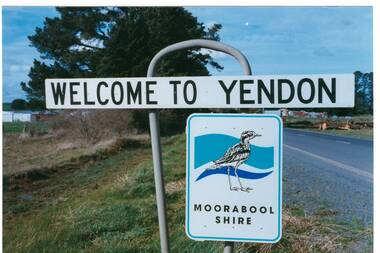
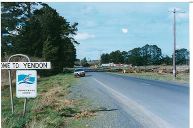
Photograph - Original Photograph, Mr. C.J. Brooks, Yendon township sign, September 1995
... Road signs...Buninyong & District Historical Society Old Court House, Buninyong Town Hall 313 Learmonth Street Buninyong goldfields Social, historical Yendon township sign taken in September 1995 showing the Moorabool Shire signage of that time Road signs Yendon Moorabool Shire Streetscape Colour photo, Welcome to Yendon Sign on the Western outskirts of the township Yendon township sign Photograph Original Photograph Mr. ...Social, historicalYendon township sign taken in September 1995 showing the Moorabool Shire signage of that timeColour photo, Welcome to Yendon Sign on the Western outskirts of the townshiproad signs, yendon, moorabool shire, streetscape -
 Buninyong & District Historical Society
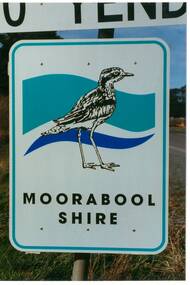
Photograph - Original Photograph, Mr. C.J. Brooks, Moorabool Shire sign closeup, September 1995
... Road signs...Buninyong & District Historical Society Old Court House, Buninyong Town Hall 313 Learmonth Street Buninyong goldfields Social, historical Example of the Moorabool Shire sign in the late twentieth century Road signs Yendon Moorabool Shire Streetscape Colour photo, closeup of the Moorabool Shire sign on the Western outskirts of the township of Yendon Moorabool Shire sign closeup Photograph Original Photograph Mr. ...Social, historicalExample of the Moorabool Shire sign in the late twentieth centuryColour photo, closeup of the Moorabool Shire sign on the Western outskirts of the township of Yendonroad signs, yendon, moorabool shire, streetscape -
 Buninyong & District Historical Society
Photograph - Original Photograph, Mr. C.J. Brooks, Main street of Yendon from the West, September 1995
... Road signs...Buninyong & District Historical Society Old Court House, Buninyong Town Hall 313 Learmonth Street Buninyong goldfields Social, historical Example of the Moorabool Shire sign and the felling of trees for power company in the late twentieth century Road signs Yendon Moorabool Shire Streetscape Felled pinetrees Powercor Colour photo, of the Western outskirts of the township of Yendon showing 8-10 felled pine trees of the southern side of avenue Main street of Yendon from the West Photograph Original Photograph Mr. ...Social, historicalExample of the Moorabool Shire sign and the felling of trees for power company in the late twentieth centuryColour photo, of the Western outskirts of the township of Yendon showing 8-10 felled pine trees of the southern side of avenueroad signs, yendon, moorabool shire, streetscape, felled pinetrees, powercor -
 Melbourne Tram Museum
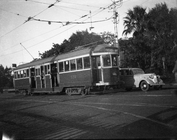
Negative - Copy - W2 533 Balaclava Junction, late 1940s
... Road...signs...Copy negative of a photograph of W2 class tram 533 about to do a right hand turn from Hawthorn Road into Balaclava Road, with a destination of St Kilda Beach via Balaclava Road, Route 69. Behind the tram is a sign stating the trams could be taken to Balaclava, St Kilda Beach and Caulfield, along with a tram stop sign and an End Section sign....Yields information about the use of W2 class trams tramcars tramways Caulfield Hawthorn Road signs Balaclava Junction W2 class tram 533 Route 69 Copy negative of a black and white photograph Negative Copy - W2 533 Balaclava Junction ...Copy negative of a photograph of W2 class tram 533 about to do a right hand turn from Hawthorn Road into Balaclava Road, with a destination of St Kilda Beach via Balaclava Road, Route 69. Behind the tram is a sign stating the trams could be taken to Balaclava, St Kilda Beach and Caulfield, along with a tram stop sign and an End Section sign.Yields information about the use of W2 class tramsCopy negative of a black and white photographtramcars, tramways, caulfield, hawthorn road, signs, balaclava junction, w2 class, tram 533, route 69 -
 Melbourne Tram Museum
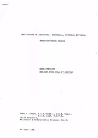
Document - Report, John L Grigg, Chief Engineer MMTB, "Tram Priority - How and when will it happen", Apr. 1983
... ... Road Signs...Melbourne Tram Museum 8 Wallen Road Hawthorn melbourne Trams tramways Tramways Road Signs Traffic Lights Tram Priority Traffic Control Report - 27 pages, photocopied, stapled in top left hand corner, titled "Tram Priority - How and when will it happen" written by John L Grigg, Chief Engineer MMTB, 20 April 1983. ...Report - 27 pages, photocopied, stapled in top left hand corner, titled "Tram Priority - How and when will it happen" written by John L Grigg, Chief Engineer MMTB, 20 April 1983. Report looks impact of traffic light controls, tram only lanes, clearways, right turns, results of tests and trials. Has many charts, graphs and diagrams. Presented 20/4/1983, at IEAust Transportation Branch meeting with Ian McDonald, City Engineer Prahran.trams, tramways, tramways, road signs, traffic lights, tram priority, traffic control -
 Melbourne Tram Museum
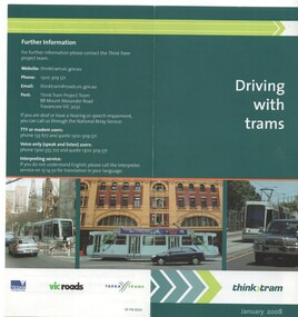
Pamphlet, VicRoads, "Driving with trams", Jan. 2008
... ... Road Signs...Melbourne Tram Museum 8 Wallen Road Hawthorn melbourne Trams tramways Road Signs VicRoads Yarra Trams Motor vehicles Motor Buses Pamphlet - set of two. 1 - two fold DL, full colour on off white paper, titled "Driving with trams', explaining the rules about driving vehicles around trams, tram lanes, road rules. ...Pamphlet - set of two. 1 - two fold DL, full colour on off white paper, titled "Driving with trams', explaining the rules about driving vehicles around trams, tram lanes, road rules. Has contact details on the rear. Dated Jan. 2008 Has VicRoads, Yarra Trams and Vic. Govt. logos. 2 - four fold DL, similar to above, including bus lanes, dated April 2010. See Reg Item 243 for a DVD with the same title.trams, tramways, road signs, vicroads, yarra trams, motor vehicles, motor buses -
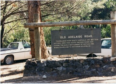
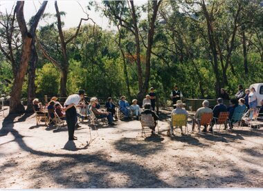 Stawell Historical Society Inc
Photograph, Old Adelaide Road - Roses Gap, 29/04/1997
... 2 Colour Photographs; 1 Showing Old Adelaide road sign. 1 Large group of people outside....Stawell Historical Society Inc 46 Longfield St Stawell grampians Roses Gap 2 Colour Photographs; 1 Showing Old Adelaide road sign. 1 Large group of people outside. Old Adelaide Road - Roses Gap Photograph ...2 Colour Photographs; 1 Showing Old Adelaide road sign. 1 Large group of people outside.roses gap -
 Stawell Historical Society Inc
Photograph, Old Adelaide Road - Roses Gap, 29/04/1997
... 2 Colour Photographs; 1 Showing Old Adelaide road sign. 1 Large group of people outside....Stawell Historical Society Inc 46 Longfield St Stawell grampians Roses Gap 2 Colour Photographs; 1 Showing Old Adelaide road sign. 1 Large group of people outside. Old Adelaide Road - Roses Gap Photograph ...2 Colour Photographs; 1 Showing Old Adelaide road sign. 1 Large group of people outside.roses gap