Showing 138 items matching " road traffic signs"
-
 Musculoskeletal Health Australia (now held by the Glen Eira Historical Society)
Photograph - Objects, 2003
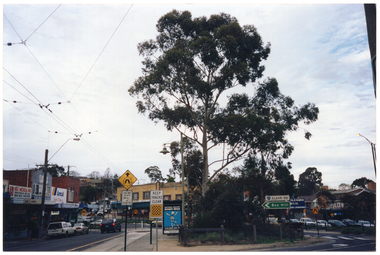
... ... road traffic signs...In the foreground, there are several road traffic signs. Around and behind the bus shelter, there are various retail stores....In the foreground, there are several road traffic signs. Around and behind the bus shelter, there are various retail stores. ...This photo depicts a 'National Healthy Bones Week' promotional billboard in situ on a bus shelter. The bus shelter is located at the Elgar and Riversdale Rds intersection, in Burwood.COL photo of a large advertisement on the side of a bus shelter. In the foreground, there are several road traffic signs. Around and behind the bus shelter, there are various retail stores.arthritis foundation of victoria, afv, osteoporosis victoria, ov, national healthy bones week, nhbw, advertisement, promotion, billboard, poster, bus shelter, bus stop, shops, retails stores, road traffic signs, street signs, 2003 -
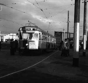
 Melbourne Tram Museum
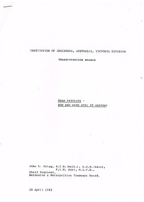
Document - Report, John L Grigg, Chief Engineer MMTB, "Tram Priority - How and when will it happen", Apr. 1983
... ... Road Signs... Traffic...Melbourne Tram Museum 8 Wallen Road Hawthorn melbourne Trams tramways Tramways Road Signs Traffic Lights Tram Priority Traffic Control Report - 27 pages, photocopied, stapled in top left hand corner, titled "Tram Priority - How and when will it happen" written by John L Grigg, Chief Engineer MMTB, 20 April 1983. ...Report - 27 pages, photocopied, stapled in top left hand corner, titled "Tram Priority - How and when will it happen" written by John L Grigg, Chief Engineer MMTB, 20 April 1983. Report looks impact of traffic light controls, tram only lanes, clearways, right turns, results of tests and trials. Has many charts, graphs and diagrams. Presented 20/4/1983, at IEAust Transportation Branch meeting with Ian McDonald, City Engineer Prahran.trams, tramways, tramways, road signs, traffic lights, tram priority, traffic control -
 Kiewa Valley Historical Society
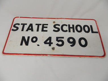
Sign - Bogong State School
... The nearest school would have been 14 miles away and over mountain roads subject to heavy construction traffic and extremes of climatic conditions. state school. bogong. education. state electricity of victoria. kiewa hydro electric scheme. "State School / No. 4590" Metal sign ...Bogong State School opened in 1941 to provide an education for the employees of the State Electricity Commission of Victoria. The school had up to date equipment and received glowing reports from School inspectors. It closed c1986.Historical: The Bogong State School was opened for the children of S.E.C.V. workers who lived at Bogong in a remote part of north east Victoria. The nearest school would have been 14 miles away and over mountain roads subject to heavy construction traffic and extremes of climatic conditions. Metal sign painted white with thin red border and black block capital letters and numbers. There is a hole in the middle top and middle bottom of the sign."State School / No. 4590"state school. bogong. education. state electricity of victoria. kiewa hydro electric scheme. -
 Bendigo Military Museum
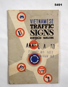
Booklet - VIETNAMESE TRAFFIC SIGNS, C 1962-1972
... Grey and white with road signs in red and blue. !5 pages of traffic signs. ...Vietnam War Book Front cover- “Vietnamese Traffic Signs, with English Translations”C Booklet- cardboard cover, bound with 2 staples. Grey and white with road signs in red and blue. ! ...See Cat 5490.Booklet- cardboard cover, bound with 2 staples. Grey and white with road signs in red and blue. !5 pages of traffic signs. Front cover- “Vietnamese Traffic Signs, with English Translations”Cvietnam war, book -
 Eltham District Historical Society Inc
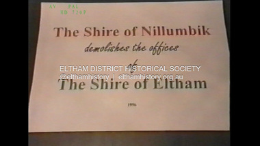
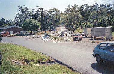
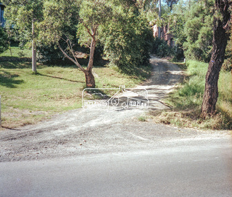
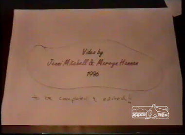
Film - Video (VHS), Jenni Mitchell, Demolition of the Shire of Eltham Offices, 1996
... Scene (1 August 1996) again driving along Main Road towards the Shire Offices then scenes of the offices showing substantially more demolition to exterior, groups of people standing on footpath outside watching, Delta heavy demolition machines, woman holding sign “Democracy where have you gone …”, the odd person in full protection gear and breathing apparatus hand carrying materials out to place on rubbish pile in front of people standing on footpath watching (with no protection) and then stamping on it to break it creating dust, security person in hard hat (no other protection) wandering around, many groups standing around watching, news film crew, person standing on roadside edge holding signs facing traffic stating “Pirate Planning” and “ Grant us your ears” also sign on back of parked car “Elthams High Jacks”, another sign “Community Democracy”, views of crosses in Main Road median strip “RIP Community”, groups of people on footpaths and reporters conducting interviews, footage of unknown person standing with Jenni Mitchell and Sigmund Jorgensen advising people have the right to protest, Jenni Mitchell urging people to ask questions of local MP and Council and Sigmund Jorgensen referring to the three historic Shillinglaw trees with demolition machinery operating in background, Jenni Mitchell and others installing more crosses in median strip; demolition machines operating inside and outside the building, more views of onlookers including Sigmund Jorgensen then Police approaching on footpath, workers and machinery continuing to operate, views of the old library being demolished, the former Community Services department, security personnel. ...Scene (1 August 1996) again driving along Main Road towards the Shire Offices then scenes of the offices showing substantially more demolition to exterior, groups of people standing on footpath outside watching, Delta heavy demolition machines, woman holding sign “Democracy where have you gone …”, the odd person in full protection gear and breathing apparatus hand carrying materials out to place on rubbish pile in front of people standing on footpath watching (with no protection) and then stamping on it to break it creating dust, security person in hard hat (no other protection) wandering around, many groups standing around watching, news film crew, person standing on roadside edge holding signs facing traffic stating “Pirate Planning” and “ Grant us your ears” also sign on back of parked car “Elthams High Jacks”, another sign “Community Democracy”, views of crosses in Main Road median strip “RIP Community”, groups of people on footpaths and reporters conducting interviews, footage of unknown person standing with Jenni Mitchell and Sigmund Jorgensen advising people have the right to protest, Jenni Mitchell urging people to ask questions of local MP and Council and Sigmund Jorgensen referring to the three historic Shillinglaw trees with demolition machinery operating in background, Jenni Mitchell and others installing more crosses in median strip; demolition machines operating inside and outside the building, more views of onlookers including Sigmund Jorgensen then Police approaching on footpath, workers and machinery continuing to operate, views of the old library being demolished, the former Community Services department, security personnel. ...Poor video quality (noise and interference), edited raw footage with music and some commentary by Merv Hanna. A video documenting the demolition of the Shire of Eltham offices at 895 Main Road Eltham under the direction of the Commissioners appointed for the new Shire of Nillumbik and some of the communities activities surrounding the event. The building was demolished exactly 25 years after the southern wing housing Engineering and Planning on the upper level and the Eltham Library on the ground level was opened in celebration of the Shire of Eltham's centenary. Video has lots of distortion and noise, and sections of clips dubbed over. Immediate initial footage of Jenni Mitchell talking about asbestos claims in the Shire Offices (Sigmund Jorgensen standing behind her) advising Council did a review of the building several years previously and had been cleared of health problems. Cuts to group of people standing outside front door of offices but possibly voice dub over not related ? Then the date 27 Jul 1996 on a scene flashes on screen immediately followed by an edited clip intro of title and credits with classical music track. It then opens with Jenni Mitchell driving to the Shire Offices on Saturday 27 July 1996 at 11.00am. Footage of Main Road past Pitt Street, Alistair Knox Park then entering Shire Office driveway which is fenced off and contractor signs hanging up. Scenes at rear of building showing some internal demolition has commenced. View of the Administration wing. More clips of road driving, Alistair Knox Park, Eltham Library and visitor car park for Shire Offices. Cuts to a group of people standing in access to visitor carpark with new Eltham Library in background, one being immediate former Shire of Eltham President, John Graves. Scenes of people looking through chain link fence and security guard checking front door. John Graves being filmed that someone informed him the Shire was offering the building to the Community Health Centre for $2.3 million and that if they had been offered a price of $1.1 for what it apparently was sold for they would have snapped it up. View of truck loaded with brick rubble literally struggling to ascend the hill of Library Place to exit into Main Road. Cuts to a scene looking at Eltham War memorial Hall through the Memorial Gate, then the Shillinglaw trees and large banner sign ‘Delta Demolitions’ hanging on office façade. Views of front door, old library and bluestone wall. Scene (31 Jul 1996) filmed at night of several white crosses with “RIP Community” and “RIP Democracy”. Scene (1 August 1996) again driving along Main Road towards the Shire Offices then scenes of the offices showing substantially more demolition to exterior, groups of people standing on footpath outside watching, Delta heavy demolition machines, woman holding sign “Democracy where have you gone …”, the odd person in full protection gear and breathing apparatus hand carrying materials out to place on rubbish pile in front of people standing on footpath watching (with no protection) and then stamping on it to break it creating dust, security person in hard hat (no other protection) wandering around, many groups standing around watching, news film crew, person standing on roadside edge holding signs facing traffic stating “Pirate Planning” and “ Grant us your ears” also sign on back of parked car “Elthams High Jacks”, another sign “Community Democracy”, views of crosses in Main Road median strip “RIP Community”, groups of people on footpaths and reporters conducting interviews, footage of unknown person standing with Jenni Mitchell and Sigmund Jorgensen advising people have the right to protest, Jenni Mitchell urging people to ask questions of local MP and Council and Sigmund Jorgensen referring to the three historic Shillinglaw trees with demolition machinery operating in background, Jenni Mitchell and others installing more crosses in median strip; demolition machines operating inside and outside the building, more views of onlookers including Sigmund Jorgensen then Police approaching on footpath, workers and machinery continuing to operate, views of the old library being demolished, the former Community Services department, security personnel. Scene (2 August 1996) more heavy demolition machinery in operation smashing building up, people standing around southern wing watching, view overlooking Eltham Library of train pulling in to Eltham station. Scene (7 August 1996) more heavy demolition and people wandering around with only hard hat protection, no dust protection, comments from one operator dumping a bin of material stating “wait till there’s a Hungry Jack’s here, you’ll be laughing, fuel, videos, hamburgers. You’ll be up with the rest of the world soon, you’ll have electricity and everything here, ha ha ha ha”, more heavy machinery demolition and breaking up of materials, view of Hitachi train going by and Administration wing, view inside the front door opening of the staircase leading to upper level, person walking around operating heavy machinery with a hose spraying rubble (no protective gear other than hard hat interspersed with edit cuts of meeting of Commissioners and independent observers on panel as well as members of the community in public gallery. Nillumbik Shire CEO Barry Rochford addressing the meeting., Chief Commissioner Don Cordell directly addressing Jenni Mitchell with respect to permission to take photographs, Barry Rochford continues to address the question asked of Council about the valuation of the former Shire of Eltham Office building/site, public gallery calling out asking why was building demolished, what was the urgency. Scene (14 August 1996) views of southern wing, previous single demolition operator again mocking people filming, operators working in and around building, Shillinglaw trees and largely demolished front, heavy demolition equipment at work, piles of building rubble, hose spraying water over rubble, large trucks arriving for rubble removal and loading of truck. Scene (21 August) more of the same, building virtually down, Shillinglaw trees standing tall and alone, water spraying on rubble and wattle in bloom. Cuts to Council meeting with public onlookers. Barry Rochford walks out, Wayne Phillips addresses meeting explaining one or two people shouting, members of the community challenging Council (Commissioners) about why due process appear to have been subverted. Former Shire President Robert Marshall in public audience, cuts back to Shire office carpark entrance site and sign hung on fence in front of library “Think Again!” and people standing around observing awaiting a protest demonstration erecting a large sign on stilts stating “Shell No!”, people singing a revised version of God Save the Queen (God Save Us All), Sigmund Jorgensen in attendance, Jenni Mitchell, Sigmund Jorgenson and others address the protest crowd, followed by people mingling, music being played then people standing around the cleared site circumference all with arms linked (video very broken up with noise) then chants “Save the Gateway” and “No Shell for Eltham” and more music and singing “Put up a parking lot”. The crowd then proceeds to walk along the footpath of Main Road. Scene (15 Sep 1996) meeting at Montsalvat in Great Hall addressed by Sigmund Jorgensen discussing a recently published list of the Commissioner’s to senior Council Officers of banned Nillumbik people, others encouraging people to view proposed plans for the site and lodge objections. Specific issues regarding asbestos claims are also addressed. Harry Gilham addresses the meeting on the subject of the Eltham War Memorial and Memorial Gardens and how Council believe a roundabout in the vicinity is of greater importance. Views of various artworks on display (for auction) and music performance in the Barn Gallery. Meeting addressed by Sigmund Jorgensen discussing an appeal against Council granting a permit to Dallas Howgate to develop the site and that the Minister has called the matter in to be decided by the governing council. This is followed by an auction of paintings.Hi-Tech Ultra High Grade Video Cassette E-180 VHS dubbing of (poor quality) edited raw footage with some music from Star Wars and commentary by Merv Hannan Converted to MP4 file format 0:30:26, 2.6GBOn label " Merv's Demolition tape No. 2 Copy"video recording, 895 main road, alistair knox park, artworks, auction, barn gallery, barry rochford, community health centre, dallas howgate, delta demolitions, demolition, don cordell, eltham, eltham library, eltham shire office, eltham war memorial, eltham war memorial gate, eltham war memorial hall, great hall, harry gilham, jenni mitchell, john graves, library place, main road, memorial gardens, mervyn hannan, montsalvat, pitt street, protest, robert marshall, roundabout, shell oil, shillinglaw trees, sigmund jorgensen, sign, wayne phillips -
 Glen Eira Historical Society
Document - NEERIM ROAD RAILWAY CROSSING AND GATES GLEN HUNTLY
... Road Railway Buildings Railway Stations Land Transport Transport Establishments Hordern A.G. Dunstan Don Hordern Bill Needham J.G. Advertisements Graphics Advertising Advertising Signs Signs Estate Agents Business People Stockdale and Leggo Buildings Structures and Establishments Occupations United Signs Signs Communication Devices Motor Vehicles Glenhuntly Railway Station Town Planning Civic and Landscape Art Engineers Professionals Traffic Road Transport Transport Maps Documents Plans Document NEERIM ROAD RAILWAY CROSSING AND GATES GLEN HUNTLY ...This file contains two items: 1/Twelve photographs of the Glen Huntly, Neerim Road hand-operated railway gates, dated 1983 and November 1985, photographer unknown, and two black and white copies of two of the original photographs. Four photographs are in black and white and eight are in colour, all picturing the Gatekeeper’s shelter and/or the railway gates. Six photographs dated 1985 include the Gatekeeper, unidentified, in some photos operating the gates. 2/A three-page pamphlet dated 03/05/1979 promoting a public meeting at the Caulfield Town Hall to debate Road Grade Separation proposals for the Neerim Road and Glenhuntly Road railway crossings. Document details the proposed VicRail improvement and four alternative improvements as we as a blank questionnaire for the submission of ideas regarding the proposals to the Caulfield City Council Urban Planner. A short summary of other concerns held by two councillors and an engineer regarding the proposal is also included, as is a Railway Noise Level. Railway Pamphlet also includes a map of the area surrounding the railway crossings under discussion 1977.glenhuntly road, neerim road, caulfield, railway gates, gates, hand-operated railway gates, railways, roads and streets, railway crossings, architectural features, town halls, official buildings, vicrail, meetings, public meetings, caulfield town hall, gatekeepers, caulfield city council, elsternwick, glen huntly, caulfield park, caulfield racecourse, normanby road, dandenong road, railway buildings, railway stations, land transport, transport establishments, hordern a.g., dunstan don, hordern bill, needham j.g., advertisements, graphics, advertising, advertising signs, signs, estate agents, business people, stockdale and leggo, buildings structures and establishments, occupations, united signs, signs, communication devices, motor vehicles, glenhuntly railway station, town planning, civic and landscape art, engineers, professionals, traffic, road transport, transport, maps, documents, plans -
 Lorne Historical Society
Photograph, G.O.R: Horse and dray:
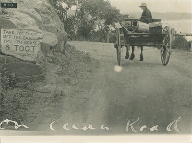
... Lorne Historical Society Lorne Community House Mountjoy Parade Lorne great-ocean-road Horse and dray: sign welcoming traffic: G.O.R Horse and dray sign welcoming traffic. ...Horse and dray sign welcoming traffic.horse and dray: sign welcoming traffic: g.o.r -
 Eltham District Historical Society Inc
Document - Property Binder, 907 Main Road, Eltham
... (Other items include: St Andrews Submission Re application to subdivide 1726 Heidelberg-Kinglake Road; Minister's decision awaited - A six-eight lot subdivision at Eagles Nest Road, Strathewen; Mt Pleasant Rd petition - Need for a shared pathway; Policy on ad signs - Amended policy on advertising signs for community events; Main Rd streetscape plan - Plans for streetscape improvement in Main Road to go on display; Special meeting dates set - Special meetings to consider formal submissions and then adopt a final proposal for Shire's electoral structure for Ministerial approval and gazettal. Letter Eltham District Historical Society to Nillumbik Shire Council, 16 September 1996: Proposed roundabouts Main Road Eltham at Dudley Street and Panther Place. Newspaper article: Diamond Valley News 16 October 1996, Pre-school welcomes plan for traffic...(Other items include: St Andrews Submission Re application to subdivide 1726 Heidelberg-Kinglake Road; Minister's decision awaited - A six-eight lot subdivision at Eagles Nest Road, Strathewen; Mt Pleasant Rd petition - Need for a shared pathway; Policy on ad signs - Amended policy on advertising signs for community events; Main Rd streetscape plan - Plans for streetscape improvement in Main Road to go on display; Special meeting dates set - Special meetings to consider formal submissions and then adopt a final proposal for Shire's electoral structure for Ministerial approval and gazettal. Letter Eltham District Historical Society to Nillumbik Shire Council, 16 September 1996: Proposed roundabouts Main Road Eltham at Dudley Street and Panther Place. Newspaper article: Diamond Valley News 16 October 1996, Pre-school welcomes plan for traffic ...Newspaper article: $6000 grant to Our Lady's, The Advertiser, July 2, 1996 - Grant given to Parish of Our LadyHelp of Christians which is taking over the use of the Eltham War Memorial Hall in Main Road and the Nillumbik After School Program. (Other items include: St Andrews Submission Re application to subdivide 1726 Heidelberg-Kinglake Road; Minister's decision awaited - A six-eight lot subdivision at Eagles Nest Road, Strathewen; Mt Pleasant Rd petition - Need for a shared pathway; Policy on ad signs - Amended policy on advertising signs for community events; Main Rd streetscape plan - Plans for streetscape improvement in Main Road to go on display; Special meeting dates set - Special meetings to consider formal submissions and then adopt a final proposal for Shire's electoral structure for Ministerial approval and gazettal. Letter Eltham District Historical Society to Nillumbik Shire Council, 16 September 1996: Proposed roundabouts Main Road Eltham at Dudley Street and Panther Place. Newspaper article: Diamond Valley News 16 October 1996, Pre-school welcomes plan for traffic lights.main road, eltham, property, roundabouts, dudley street, panther place, eltham pre-school, eltham war memorial -
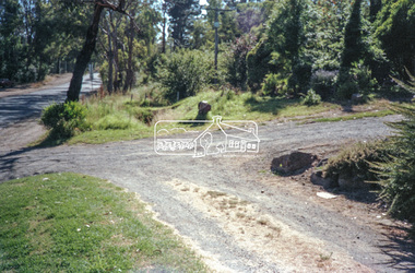
 Eltham District Historical Society Inc
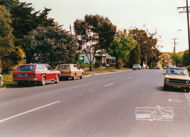
Negative - Photograph, Main Road, Eltham, c.Dec. 1983
... Road sign advising of proposed reconstruction works of Main Road to install a roundabout at Mount Pleasant Road. Traffic...Eltham District Historical Society Inc 728 Main Rd Eltham melbourne Road sign advising of proposed reconstruction works of Main Road to install a roundabout at Mount Pleasant Road. Traffic ...Road sign advising of proposed reconstruction works of Main Road to install a roundabout at Mount Pleasant Road. Traffic to Lower Plenty and Templestowe to be diverted down Bridge Street (and Bolton Street) effective January 1984. The proposed roundabout did not proceed. Instead traffic islands on Mount Pleasant Road were installed in place of temporary blocked out islands.Film - Kodak CM 400 5079 7 strips, 26 framesinfrastructure, roads, road construction, roundabout, road sign, main road, mount pleasant road -
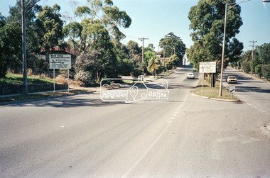
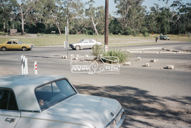
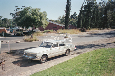
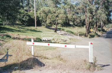
 Eltham District Historical Society Inc
Negative - Photograph, Intersection of Mt Pleasant Road at Main Road, Eltham, c.Dec. 1983
... Road. Traffic to Lower Plenty and Templestowe to be diverted down Bridge Street (and Bolton Street) effective January 1984. The proposed roundabout did not proceed. Instead traffic islands on Mount Pleasant Road were installed in place of temporary blocked out islands and revised extended driveway to properties 622-642 Main Road with access off Mount Pleasant Road instead. infrastructure roads road construction roundabout road sign main road mount pleasant road eltham Film - Kodak CM 400 5079 7 strips, 26 frames Intersection of Mt Pleasant Road at Main Road, Eltham Negative Photograph ...Reconstruction work was planned for Main Road to install a roundabout at Mount Pleasant Road. Traffic to Lower Plenty and Templestowe to be diverted down Bridge Street (and Bolton Street) effective January 1984. The proposed roundabout did not proceed. Instead traffic islands on Mount Pleasant Road were installed in place of temporary blocked out islands and revised extended driveway to properties 622-642 Main Road with access off Mount Pleasant Road instead.Film - Kodak CM 400 5079 7 strips, 26 framesinfrastructure, roads, road construction, roundabout, road sign, main road, mount pleasant road, eltham -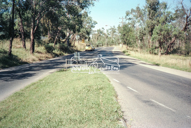
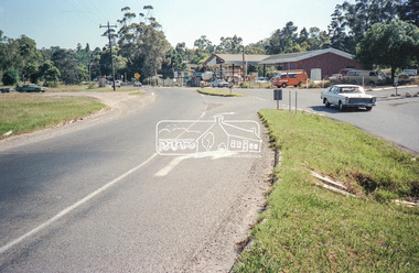 Eltham District Historical Society Inc
Negative - Photograph, Intersection of Mt Pleasant Road at Main Road, Eltham, c.Dec. 1983
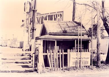
... Road. Traffic to Lower Plenty and Templestowe to be diverted down Bridge Street (and Bolton Street) effective January 1984. The proposed roundabout did not proceed. Instead traffic islands on Mount Pleasant Road were installed in place of temporary blocked out islands and revised extended driveway to properties 622-642 Main Road with access off Mount Pleasant Road instead. infrastructure roads road construction roundabout road sign main road mount pleasant road eltham Service Station Film - Kodak CM 400 5079 7 strips, 26 frames Intersection of Mt Pleasant Road at Main Road, Eltham Negative Photograph ...Reconstruction work was planned for Main Road to install a roundabout at Mount Pleasant Road. Traffic to Lower Plenty and Templestowe to be diverted down Bridge Street (and Bolton Street) effective January 1984. The proposed roundabout did not proceed. Instead traffic islands on Mount Pleasant Road were installed in place of temporary blocked out islands and revised extended driveway to properties 622-642 Main Road with access off Mount Pleasant Road instead.Film - Kodak CM 400 5079 7 strips, 26 framesinfrastructure, roads, road construction, roundabout, road sign, main road, mount pleasant road, eltham, service station -
 Eltham District Historical Society Inc
Negative - Photograph, Intersection of Mt Pleasant Road at Main Road, Eltham, c.Dec. 1983
... Road. Traffic to Lower Plenty and Templestowe to be diverted down Bridge Street (and Bolton Street) effective January 1984. The proposed roundabout did not proceed. Instead traffic islands on Mount Pleasant Road were installed in place of temporary blocked out islands and revised extended driveway to properties 622-642 Main Road with access off Mount Pleasant Road instead. infrastructure roads road construction roundabout road sign main road mount pleasant road eltham Film - Kodak CM 400 5079 7 strips, 26 frames Intersection of Mt Pleasant Road at Main Road, Eltham Negative Photograph ...Reconstruction work was planned for Main Road to install a roundabout at Mount Pleasant Road. Traffic to Lower Plenty and Templestowe to be diverted down Bridge Street (and Bolton Street) effective January 1984. The proposed roundabout did not proceed. Instead traffic islands on Mount Pleasant Road were installed in place of temporary blocked out islands and revised extended driveway to properties 622-642 Main Road with access off Mount Pleasant Road instead.Film - Kodak CM 400 5079 7 strips, 26 framesinfrastructure, roads, road construction, roundabout, road sign, main road, mount pleasant road, eltham -
 Eltham District Historical Society Inc
Negative - Photograph, Intersection of Mt Pleasant Road at Main Road, Eltham, c.Dec. 1983
... Road. Traffic to Lower Plenty and Templestowe to be diverted down Bridge Street (and Bolton Street) effective January 1984. The proposed roundabout did not proceed. Instead traffic islands on Mount Pleasant Road were installed in place of temporary blocked out islands and revised extended driveway to properties 622-642 Main Road with access off Mount Pleasant Road instead. infrastructure roads road construction roundabout road sign main road mount pleasant road eltham Film - Kodak CM 400 5079 7 strips, 26 frames Intersection of Mt Pleasant Road at Main Road, Eltham Negative Photograph ...Reconstruction work was planned for Main Road to install a roundabout at Mount Pleasant Road. Traffic to Lower Plenty and Templestowe to be diverted down Bridge Street (and Bolton Street) effective January 1984. The proposed roundabout did not proceed. Instead traffic islands on Mount Pleasant Road were installed in place of temporary blocked out islands and revised extended driveway to properties 622-642 Main Road with access off Mount Pleasant Road instead.Film - Kodak CM 400 5079 7 strips, 26 framesinfrastructure, roads, road construction, roundabout, road sign, main road, mount pleasant road, eltham -
 Eltham District Historical Society Inc
Film - Video (VHS), Jenni Mitchell, Demolition of the Shire of Eltham Offices, 1996
... Scene (1 August 1996) again driving along Main Road towards the Shire Offices then scenes of the offices showing substantially more demolition to exterior, groups of people standing on footpath outside watching, Delta heavy demolition machines, woman holding sign “Democracy where have you gone …”, the odd person in full protection gear and breathing apparatus hand carrying materials out to place on rubbish pile in front of people standing on footpath watching (with no protection) and then stamping on it to break it creating dust, security person in hard hat (no other protection) wandering around, many groups standing around watching, news film crew, person standing on roadside edge holding signs facing traffic stating “Pirate Planning” and “ Grant us your ears” also sign on back of parked car “Elthams High Jacks”, another sign “Community Democracy”, views of crosses in Main Road median strip “RIP Community”, groups of people on footpaths and reporters conducting interviews, footage of unknown person standing with Jenni Mitchell and Sigmund Jorgensen advising people have the right to protest, Jenni Mitchell urging people to ask questions of local MP and Council and Sigmund Jorgensen referring to the three historic Shillinglaw trees with demolition machinery operating in background, Jenni Mitchell and others installing more crosses in median strip; demolition machines operating inside and outside the building, more views of onlookers including Sigmund Jorgensen then Police approaching on footpath, workers and machinery continuing to operate, views of the old library being demolished, the former Community Services department, security personnel. ...Scene (1 August 1996) again driving along Main Road towards the Shire Offices then scenes of the offices showing substantially more demolition to exterior, groups of people standing on footpath outside watching, Delta heavy demolition machines, woman holding sign “Democracy where have you gone …”, the odd person in full protection gear and breathing apparatus hand carrying materials out to place on rubbish pile in front of people standing on footpath watching (with no protection) and then stamping on it to break it creating dust, security person in hard hat (no other protection) wandering around, many groups standing around watching, news film crew, person standing on roadside edge holding signs facing traffic stating “Pirate Planning” and “ Grant us your ears” also sign on back of parked car “Elthams High Jacks”, another sign “Community Democracy”, views of crosses in Main Road median strip “RIP Community”, groups of people on footpaths and reporters conducting interviews, footage of unknown person standing with Jenni Mitchell and Sigmund Jorgensen advising people have the right to protest, Jenni Mitchell urging people to ask questions of local MP and Council and Sigmund Jorgensen referring to the three historic Shillinglaw trees with demolition machinery operating in background, Jenni Mitchell and others installing more crosses in median strip; demolition machines operating inside and outside the building, more views of onlookers including Sigmund Jorgensen then Police approaching on footpath, workers and machinery continuing to operate, views of the old library being demolished, the former Community Services department, security personnel. ...Poor video quality (noise and interference), incomplete and unedited raw footage. A video documenting the demolition of the Shire of Eltham offices at 895 Main Road Eltham under the direction of the Commissioners appointed for the new Shire of Nillumbik and some of the communities activities surrounding the event. The building was demolished exactly 25 years after the southern wing housing Engineering and Planning on the upper level and the Eltham Library on the ground level was opened in celebration of the Shire of Eltham's centenary. Video has lots of distortion and noise, and sections of clips dubbed over. Immediate initial footage of Jenni Mitchell talking about asbestos claims in the Shire Offices (Sigmund Jorgensen standing behind her) advising Council did a review of the building several years previously and had been cleared of health problems. Cuts to group of people standing outside front door of offices but possibly voice dub over not related ? Then the date 27 Jul 1996 on a scene flashes on screen immediately followed by an edited clip intro of title and credits with classical music track. It then opens with Jenni Mitchell driving to the Shire Offices on Saturday 27 July 1996 at 11.00am. Footage of Main Road past Pitt Street, Alistair Knox Park then entering Shire Office driveway which is fenced off and contractor signs hanging up. Scenes at rear of building showing some internal demolition has commenced. View of the Administration wing. More clips of road driving, Alistair Knox Park, Eltham Library and visitor car park for Shire Offices. Cuts to a group of people standing in access to visitor carpark with new Eltham Library in background, one being immediate former Shire of Eltham President, John Graves. Scenes of people looking through chain link fence and security guard checking front door. John Graves being filmed that someone informed him the Shire was offering the building to the Community Health Centre for $2.3 million and that if they had been offered a price of $1.1 for what it apparently was sold for they would have snapped it up. View of truck loaded with brick rubble literally struggling to ascend the hill of Library Place to exit into Main Road. Cuts to a scene looking at Eltham War memorial Hall through the Memorial Gate, then the Shillinglaw trees and large banner sign ‘Delta Demolitions’ hanging on office façade. Views of front door, old library and bluestone wall. Scene (31 Jul 1996) filmed at night of several white crosses with “RIP Community” and “RIP Democracy”. Scene (1 August 1996) again driving along Main Road towards the Shire Offices then scenes of the offices showing substantially more demolition to exterior, groups of people standing on footpath outside watching, Delta heavy demolition machines, woman holding sign “Democracy where have you gone …”, the odd person in full protection gear and breathing apparatus hand carrying materials out to place on rubbish pile in front of people standing on footpath watching (with no protection) and then stamping on it to break it creating dust, security person in hard hat (no other protection) wandering around, many groups standing around watching, news film crew, person standing on roadside edge holding signs facing traffic stating “Pirate Planning” and “ Grant us your ears” also sign on back of parked car “Elthams High Jacks”, another sign “Community Democracy”, views of crosses in Main Road median strip “RIP Community”, groups of people on footpaths and reporters conducting interviews, footage of unknown person standing with Jenni Mitchell and Sigmund Jorgensen advising people have the right to protest, Jenni Mitchell urging people to ask questions of local MP and Council and Sigmund Jorgensen referring to the three historic Shillinglaw trees with demolition machinery operating in background, Jenni Mitchell and others installing more crosses in median strip; demolition machines operating inside and outside the building, more views of onlookers including Sigmund Jorgensen then Police approaching on footpath, workers and machinery continuing to operate, views of the old library being demolished, the former Community Services department, security personnel. Scene (2 August 1996) more heavy demolition machinery in operation smashing building up, people standing around southern wing watching, view overlooking Eltham Library of train pulling in to Eltham station. Scene (7 August 1996) more heavy demolition and people wandering around with only hard hat protection, no dust protection, comments from one operator dumping a bin of material stating “wait till there’s a Hungry Jack’s here, you’ll be laughing, fuel, videos, hamburgers. You’ll be up with the rest of the world soon, you’ll have electricity and everything here, ha ha ha ha”, more heavy machinery demolition and breaking up of materials, view of Hitachi train going by and Administration wing, view inside the front door opening of the staircase leading to upper level, person walking around operating heavy machinery with a hose spraying rubble (no protective gear other than hard hat interspersed with edit cuts of meeting of Commissioners and independent observers on panel as well as members of the community in public gallery. Nillumbik Shire CEO Barry Rochford addressing the meeting., Chief Commissioner Don Cordell directly addressing Jenni Mitchell with respect to permission to take photographs, Barry Rochford continues to address the question asked of Council about the valuation of the former Shire of Eltham Office building/site, public gallery calling out asking why was building demolished, what was the urgency. Scene (14 August 1996) views of southern wing, previous single demolition operator again mocking people filming, operators working in and around building, Shillinglaw trees and largely demolished front, heavy demolition equipment at work, piles of building rubble, hose spraying water over rubble, large trucks arriving for rubble removal and loading of truck. Scene (21 August) more of the same, building virtually down, Shillinglaw trees standing tall and alone, water spraying on rubble and wattle in bloom. Cuts to Council meeting with public onlookers. Barry Rochford walks out, Wayne Phillips addresses meeting explaining one or two people shouting, members of the community challenging Council (Commissioners) about why due process appear to have been subverted. Former Shire President Robert Marshall in public audience, cuts back to Shire office carpark entrance site and sign hung on fence in front of library “Think Again!” and people standing around observing awaiting a protest demonstration erecting a large sign on stilts stating “Shell No!”, people singing a revised version of God Save the Queen (God Save Us All), Sigmund Jorgensen in attendance, Jenni Mitchell, Sigmund Jorgenson and others address the protest crowd, followed by people mingling, music being played then people standing around the cleared site circumference all with arms linked (video very broken up with noise) then chants “Save the Gateway” and “No Shell for Eltham” and more music and singing “Put up a parking lot”. The crowd then proceeds to walk along the footpath of Main Road. Scene (15 Sep 1996) meeting at Montsalvat in Great Hall addressed by Sigmund Jorgensen discussing a recently published list of the Commissioner’s to senior Council Officers of banned Nillumbik people, others encouraging people to view proposed plans for the site and lodge objections. Specific issues regarding asbestos claims are also addressed. Harry Gilham addresses the meeting on the subject of the Eltham War Memorial and Memorial Gardens and how Council believe a roundabout in the vicinity is of greater importance. Views of various artworks on display (for auction) and music performance in the Barn Gallery. Meeting addressed by Sigmund Jorgensen discussing an appeal against Council granting a permit to Dallas Howgate to develop the site and that the Minister has called the matter in to be decided by the governing council. This is followed by an auction of paintings. 0.05 - Jenni Mitchel, Sigmund Jorgensen and Peter Doughtery in background. 0.18 - Jock Kyme in front of building – David Essex, Marg Johnson on his left-hand side. 5.34 - John Graves – ex Shire of Eltham Councillor and President. 9.02 - Unknown person being interviewed. 9.30 - Jenni Mitchell, unknown person, Mark Burns, community activist. 10.04 - Sigmund Jorgenson, Jenni Mitchell. 12.04 - Police members 21.33 - Nillumbik Council offices 7 August 1996 Barry Rochford CEO, Vin Heffernan Commissioner, Don Cordell Chief Commissioner, Kevin Abbott Commissioner, unknown person. 28.00 - Barry Rochford CEO 28.05 - Kahn Frankie - in commissioner’s seat after commissioners and council staff have vacated the council chamber. 28.26 - Wayne Phillips, State Liberal member for Eltham, addressing community in response to questions. 28.36 - Mark Burns, community activist addressing gallery. 28.48 - Ken Hines, ex Shire of Eltham Councillor and President. 29.34 - Ken Hines, ex Shire of Eltham Councillor and President standing, Robert Marshall, ex Shire of Eltham Councillor and President seated in front. 29.41 - Karen Gerhards, community activist. 30.06 - Marg Johnson with loud hailer, next to Jock Kyme, community activist. 31.32 - Marg Johnson with possibly Frank Burgoyne?, Sigmund Jorgensen, Jock Kyme. 35.35 - Harry Gilham at meeting at Montsalvat on 15 September 1996. 35.43 - Sigmund Jorgenson at lectern. 36.42 - Marg Jennings. 37.47 - Mark McDonald, Jim Connor, ex Shire of Eltham Councillor in background. 36.28 - John Cohen, ex Shire of Eltham Councillor and President. 38.56 - Ken Hines, ex Shire of Eltham Councillor and President. 41.11 - Harry Gilham, president of the Eltham District Historical Society. 43.55 - Sigmund Jorgensen in Long Gallery at Montsalvat, at start of the art auction to raise funds for community action. 45.50 - Unknown person conducting art auction. VHS Video cassette (poor quality) Converted to MP4 file format 45:01, 535MBvideo recording, 895 main road, alistair knox park, artworks, auction, barn gallery, barry rochford, community health centre, dallas howgate, delta demolitions, demolition, don cordell, eltham, eltham library, eltham shire office, eltham war memorial, eltham war memorial gate, eltham war memorial hall, great hall, harry gilham, jenni mitchell, john graves, library place, main road, memorial gardens, mervyn hannan, montsalvat, pitt street, protest, robert marshall, roundabout, shell oil, shillinglaw trees, sigmund jorgensen, sign, wayne phillips -
 Eltham District Historical Society Inc
Photograph, Looking west near 942 Main Road, Hurstbridge, c. Oct 1987, 1987
... road, brick wall with a blue sign on it. There's still an older house next to the milkbar, but that's hidden from view in this shot as it's further back from the road. Date based on other similar display panels visible in images of the Shire of Eltham display at the Eltham Community Festival, 7 November 1987. Shire of Eltham Engineering Department Providing the resources to undertake • Survey, design, consultation • Road construction and maintenance • Bridge construction and maintenance • Street sweeping • Drain and pit cleaning • Traffic engineering installation and maintenance • Garbage collection • Tip management, land reclamation and beautification • Maintenance of community buildings • Provision of community and recreation facilities...road, brick wall with a blue sign on it. There's still an older house next to the milkbar, but that's hidden from view in this shot as it's further back from the road. Date based on other similar display panels visible in images of the Shire of Eltham display at the Eltham Community Festival, 7 November 1987. Shire of Eltham Engineering Department Providing the resources to undertake • Survey, design, consultation • Road construction and maintenance • Bridge construction and maintenance • Street sweeping • Drain and pit cleaning • Traffic engineering installation and maintenance • Garbage collection • Tip management, land reclamation and beautification • Maintenance of community buildings • Provision of community and recreation facilities Display panel, Eltham Festival, Heidelberg-Kinglake Road, Hurstbridge, Hurstbridge Milk Bar, Infrastructure, Main Road, MM, shire of eltham, Yvonne's Dressmaking and Alteration Service Photo print mounted on card Looking west near 942 Main Road, Hurstbridge, c. ...Yvonne's Dressmaking and Alteration Service at 942 Main Road. Formerly a bakery, the building was demolished in 1990 and is now the site of Hurstbridge Saddlery. The milkbar is down the road, brick wall with a blue sign on it. There's still an older house next to the milkbar, but that's hidden from view in this shot as it's further back from the road. Date based on other similar display panels visible in images of the Shire of Eltham display at the Eltham Community Festival, 7 November 1987. Shire of Eltham Engineering Department Providing the resources to undertake • Survey, design, consultation • Road construction and maintenance • Bridge construction and maintenance • Street sweeping • Drain and pit cleaning • Traffic engineering installation and maintenance • Garbage collection • Tip management, land reclamation and beautification • Maintenance of community buildings • Provision of community and recreation facilitiesPhoto print mounted on carddisplay panel, eltham festival, heidelberg-kinglake road, hurstbridge, hurstbridge milk bar, infrastructure, main road, mm, shire of eltham, yvonne's dressmaking and alteration service -
 Bendigo Historical Society Inc.
Administrative record - Spring Gully Gold Mining Co. Fryerstown, Minute Book1903 - 1915, 1924 - 1929
... traffic and this being the principal cause of the bridges present condition'. 4. Prospectus of the Spring Gully Mining Company, Spring Gull, Fryerstown, two page folded document enclosed inside back cover of book. Prospectus incomplete. (10746.93a) 5. Carbon copy of letter to D.E. Williams Esq, Castlemaine from GlenAthol, Casewick Road, London, January 25th, 1907 regarding two gentlemen who were 'called upon to carry the 'Spring Gullys' through - Mr. H. 'is making a determined effort to bring the matter to a successful issue' Letter signed...traffic and this being the principal cause of the bridges present condition'. 4. Prospectus of the Spring Gully Mining Company, Spring Gull, Fryerstown, two page folded document enclosed inside back cover of book. Prospectus incomplete. (10746.93a) 5. Carbon copy of letter to D.E. Williams Esq, Castlemaine from GlenAthol, Casewick Road, London, January 25th, 1907 regarding two gentlemen who were 'called upon to carry the 'Spring Gullys' through - Mr. H. 'is making a determined effort to bring the matter to a successful issue' Letter signed ...The Spring Gully Gold Mining property consists of Gold Mining Lease No. 2986, Castlemaine, of about 21 acres situated on the Emu Reef, in Spring Gully Fryers. There are two shafts, distant about 300 feet from each other. From one of them large quantities of gold were obtained in former years by previous companies. ( Prospectus of the Spring Gully Mining CompanyMaroon hard cover book, brown leather binding on spine and corners, three hundred and eighty pages. Written on spine of book in gold leaf : 'Minute Book'. Handwritten minute entries from 14th September 1903 to 30th August 1915. Affixed to first page, newspaper clipping from the 'Herald' 13/9/05, with information about the Spring Gully Mine Fryerstown. Page eighty-one has two quotes affixed from 'The Yarraville Chlorination and Ore Reduction Works' High Street Yarraville, July 1905, for works associated with pyrites and blanket sand. Page nine, a handwritten letter affixed to minutes, applying for a block of land 250 feet north of main shaft. Signed by J.S. Potter, H. Hancock, G Murray and T. Tumney. 1.Page one hundred and one: three quotes from 'Edwards' Metallurgical Works' Specimen Hill, Bendigo for pyrites and blanket sand. 2.Page one hundred and fifty five: handwritten letter (copy) from A. Schonfelder re shaft work on the mine and mention of tributors 3. Affixed to inside cover: letter from the 'United Shire of Mount Alexander' April 15th. 1907, regarding the reconstruction of the Vaughan bridge over the Loddon River. 'the benefit that the mines in your district derive from the bridge being open for wood waggons and this being the main traffic and this being the principal cause of the bridges present condition'. 4. Prospectus of the Spring Gully Mining Company, Spring Gull, Fryerstown, two page folded document enclosed inside back cover of book. Prospectus incomplete. (10746.93a) 5. Carbon copy of letter to D.E. Williams Esq, Castlemaine from GlenAthol, Casewick Road, London, January 25th, 1907 regarding two gentlemen who were 'called upon to carry the 'Spring Gullys' through - Mr. H. 'is making a determined effort to bring the matter to a successful issue' Letter signed by George Allan. (10746.93b. 6. Carbon copy of letter from E. Williams, London re proposed new company to acquire the properties of Spring G.M. Coy, Spring Gully G.M. Coy. No. 1, Sth Spring Gully G.M. Coy, Sth Spring Gully G.M. Coy Extended (10746.93c) 7. Handwritten letter to the Chairman and Directors of the Spring Gully G.M. Co. re the appointment of 'Mr. Samuel Morse Battery Manager at once, or accept my resignation as Mining Manager, for we can't agree any longer' Signed by A. Schonfelder. 8. Notice of extraordinary meeting of shareholders in Spring Gully Gold Mining Company No Liability, 22nd November 1906 at Beehive Chambers, Bendigo. Signed W.G. Blackham (Blackham & Garvin) Manager of the Company. (10746.93e) The Minute Book is part of the Margaret Roberts Collection of mining documents.bendigo, margaret roberts, , goldmining, castlemaine, spring gully gold mine, fryertown -
 Bendigo Historical Society Inc.
Postcard - ACC LOCK COLLECTION: ESTAIRES AFTER GERMAN OFFENSIVE, POSTCARD, 1914-1918
... road. Two signs on building at right - 'Steenwerck Motor Traffic' and 'Estaires'. ...road. Two signs on building at right - 'Steenwerck Motor Traffic' and 'Estaires'. ...Postcard, WW1, B&W image of Estaires after a German offensive. Damaged/ruined buildings on sides of road. Two signs on building at right - 'Steenwerck Motor Traffic' and 'Estaires'. The latter has two arrows pointing in opposite directions to other towns. Copy Z 24 See also Copy 1401.108postcard -
 Bendigo Historical Society Inc.
Postcard - ACC LOCK COLLECTION: ESTAIRES AFTER GERMAN OFFENSIVE, POST, 1914-1918
... road. Two signs on building at right - 'Steenwerck Motor Traffic' and 'Estaires'. ...road. Two signs on building at right - 'Steenwerck Motor Traffic' and 'Estaires'. ...Postcard, WW1, B&W image of Estaires after a German offensive. Damaged/ruined buildings on sides of road. Two signs on building at right - 'Steenwerck Motor Traffic' and 'Estaires'. The latter has two arrows pointing in opposite directions to other towns. Copy Z 24 See also Copy 1401.73postcard, postcard, ww1, france, estaires, ruins -
 Port Melbourne Historical & Preservation Society
Photograph - Prohibited goods sign, Ross Street, Port Melbourne, Glen Stuart
... Port Melbourne Historical & Preservation Society Port Melbourne Town Hall 333 Bay Street Port Melbourne melbourne Engineering - Roads Streets Lanes and Footpaths Ross Street Sign on lamp post in Ross Street - "Timber, coal, briquette traffic is prohibited in this street", also information re sign (Digital image on database) Photograph Prohibited goods sign, Ross Street, Port Melbourne Glen Stuart ...Sign on lamp post in Ross Street - "Timber, coal, briquette traffic is prohibited in this street", also information re sign (Digital image on database)engineering - roads streets lanes and footpaths, ross street -
 Otway Districts Historical Society
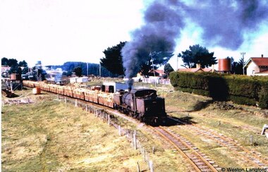
Photograph, Langford, Weston, Beech Forest: Goods trail departing for Colac, 1961, 9 August 1961
... Otway Districts Historical Society Cliff Young Drive Beech Forest great-ocean-road The Garratts were approaching 35 years of age and needed constant repairs to keep them in service, the other rolling stock was between 45 and 60 years old, the track was generally in poor condition, and the amount of traffic offering was only a faction of that carried previously and came from one station, Beech Forest. A further sign ...The Garratts were approaching 35 years of age and needed constant repairs to keep them in service, the other rolling stock was between 45 and 60 years old, the track was generally in poor condition, and the amount of traffic offering was only a faction of that carried previously and came from one station, Beech Forest. A further sign of decay was in the transfer of goods between the gauges. Where eight or nine men had worked full-time transferring between gauges only one man was seen by 1960, with several other men hired on the basis of '$2 a truck', assuming they could be found. In 1961 VR announced its intention to close the line which it did on 30 June 1962. Colour. On 9 August 1961 a G42 locomotive and goods train departing for Colac with the coal stage on the left, the saw mill and Gangers Shed on the right, and houses in the right background.. beech forest; railways; -
 Orbost & District Historical Society
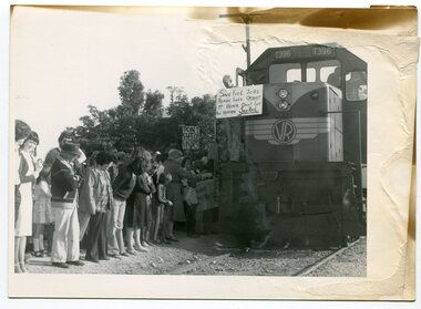
black and white photographs, C 1981
... traffic and heavy operating costs, the line was finally closed in August, 1987. The closure of this railway was a controversial issue at the time with many public protests in the district. Protesters stood in front of a VR locomotive holding up signs with " SAVE FUEL JOBS ROADS...traffic and heavy operating costs, the line was finally closed in August, 1987. The closure of this railway was a controversial issue at the time with many public protests in the district. Protesters stood in front of a VR locomotive holding up signs with " SAVE FUEL JOBS ROADS ...The Bairnsdale-Orbost railway was opened in 1916 to serve the agricultural and timber industry. Because of the decline in traffic and heavy operating costs, the line was finally closed in August, 1987. The closure of this railway was a controversial issue at the time with many public protests in the district. Protesters stood in front of a VR locomotive holding up signs with " SAVE FUEL JOBS ROADS LIVES ORBOST MR HAMER DON"T LET THIS HAPPEN SAVE RAIL" Others held placards with "DON"T CUT OFF ORBOST" and "We the Children demand our ????secure railway"This item is associated with the history of the Orbost-Bairnsdale railway line and therefore reflects the role that the rail line played in the social and economic history of Orbost. The closure of the line was a significant event in Orbost's history.Seven black / white photographs related to the closure of the Orbost Railway Line.orbost-railway east-gippsland-railway protests-rail-closure -
 Ballarat Tramway Museum
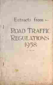
Document, State Electricity Commission of Victoria, "Extracts from Road Traffic Regulations 1958", 1/1958
... Signed by H W Linaker, Ballarat Branch Manager. Demonstrates an SEC document advising its drivers (road vehicles) of the new traffic regulations. tramways State Electricity Commission of Victoria SECV road rules regulations Traffic Control Foolscap duplicated document - 10 pages, titled "Extracts from Road Traffic Regulations 1958" and a duplicated memo dated 22/1/1958. ...Document issued to all SEC Drivers in Ballarat regarding the new regulations which came into force on 1/1/1958. Not all SEC tram Drivers would have held a formal driving licence. Lists the regulations that were relevant, though does not provide the regulations regarding tramcars. Probably focused on SEC motor car and truck drivers. Signed by H W Linaker, Ballarat Branch Manager.Demonstrates an SEC document advising its drivers (road vehicles) of the new traffic regulations.Foolscap duplicated document - 10 pages, titled "Extracts from Road Traffic Regulations 1958" and a duplicated memo dated 22/1/1958.tramways, state electricity commission of victoria, secv, road rules, regulations, traffic control -
 Ballarat Tramway Museum
Photograph - BTM Tram 18 Wendouree Parade, Warren Doubleday, 7-11-1992
... Shows the two way traffic sign that was provided at this location, ex St Georges Road....Shows the two way traffic sign that was provided at this location, ex St Georges Road. Yields information about tram 18 on the day of the launch of the horse tram. tramways BTPS tramcars Wendouree Parade tram 18 Colour print with plain back. ...Colour print of BTM tram No. 18 in Wendouree Parade at Windmill Drive North. Photo by Warren Doubleday on 7-11-1992. Shows the two way traffic sign that was provided at this location, ex St Georges Road.Yields information about tram 18 on the day of the launch of the horse tram.Colour print with plain back.tramways, btps, tramcars, wendouree parade, tram 18 -
 Ballarat Tramway Museum
Print, Geoff Grant, 25/06/1955 12:00:00 AM
... N350 and black and white print made by a laser printer (stored in folder ) of tram 980 on AETA tour (Australian Electric Traction Association) on 25/6/1955 entering shed roads at the then new East Preston depot. Tram has AETA tour signs and the slogan "Save traffic congestion, Move People not vehicles". ...N350 and black and white print made by a laser printer (stored in folder ) of tram 980 on AETA tour (Australian Electric Traction Association) on 25/6/1955 entering shed roads at the then new East Preston depot. Tram has AETA tour signs and the slogan "Save traffic congestion, Move People not vehicles". ...Negative No. N350 and black and white print made by a laser printer (stored in folder ) of tram 980 on AETA tour (Australian Electric Traction Association) on 25/6/1955 entering shed roads at the then new East Preston depot. Tram has AETA tour signs and the slogan "Save traffic congestion, Move People not vehicles". In route number box is letter "A". Negative scanned hi res and imaged updated 22/5/2020.trams, tramways, melbourne, preston depot, aeta tour, tram 980