Showing 46 items matching " south oakleigh"
-
 University of Melbourne, Burnley Campus Archives
Document, South Oakleigh Secondary College - Senior Campus. Tree Hazard Survey, 1997
... South Oakleigh Secondary College - Senior Campus. ......south oakleigh secondary college...South Oakleigh Secondary College - Senior Campus. ...Centre for Urban Horticulture, 118 pp.urban horticulture, south oakleigh secondary college, tree hazard survey -
University of Melbourne, Burnley Campus Archives
Booklet, Centre for Urban Horticulture, South Oakleigh Secondary College - Junior Campus Tree Hazard Survey, 1997
... South Oakleigh Secondary College - Junior Campus Tree Hazard Survey...south oakleigh secondary college...South Oakleigh Secondary College - Junior Campus Tree Hazard Survey Booklet Centre for Urban Horticulture Found in Quad Classrooms 2018 ...south oakleigh secondary college, tree hazards, survey -
 Melbourne Legacy
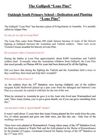
Document - Speech, Planting Lone Pine - Oakleigh South Primary School, 2007
... Planting Lone Pine - Oakleigh South Primary School...A speech by Legatee Bill Rogers at the planting of a Lone Pine tree at Oakleigh South Primary School. The dates is not noted but probably in 2007. ...Print out x 2 pages of a speech at Oakleigh South Primary School and 2 pages of the history of the Lone Pine trees....Planting Lone Pine - Oakleigh South Primary School Document Speech ...A speech by Legatee Bill Rogers at the planting of a Lone Pine tree at Oakleigh South Primary School. The dates is not noted but probably in 2007. He briefly mentions the Gallipoli campaign and then the story of how Legacy have propagated the trees as a symbol of remembrance of all the men and women who have given their lives for our nation. The two pages showing the history of the Lone Pines have been superseeded. Document was from a folder of documents donated to the archive by Legatee Bill Rogers that related to his time as President (March 2006 - March 2008).A record of a ceremony to plant a Lone Pine tree at a primary school.Print out x 2 pages of a speech at Oakleigh South Primary School and 2 pages of the history of the Lone Pine trees.lone pine, students, schools -
Glen Eira Historical Society
Document - COATESVILLE UNTING CHURCH CORNER NORTH AND MACKIE ROAD
... South Oakleigh Methodist Church...Two items about this church: 1/Photocopied details of the Church’s preliminary stages of development at Coatesville Uniting Church. 2/Photocopied article with brief details of Coatesville parish history which includes East Bentleigh Presbyterian and South Oakleigh Methodist parishes....Glen Eira Historical Society 965 Glen Huntly Rd Caulfield VIC 3162 melbourne Two items about this church: 1/Photocopied details of the Church’s preliminary stages of development at Coatesville Uniting Church. 2/Photocopied article with brief details of Coatesville parish history which includes East Bentleigh Presbyterian and South Oakleigh Methodist parishes. South Oakleigh Methodist Church Reid A North Road Coatesville Uniting Church Bray Mr Mackie Road Harris Mr Phillips L.G. ...Two items about this church: 1/Photocopied details of the Church’s preliminary stages of development at Coatesville Uniting Church. 2/Photocopied article with brief details of Coatesville parish history which includes East Bentleigh Presbyterian and South Oakleigh Methodist parishes.south oakleigh methodist church, reid a, north road, coatesville uniting church, bray mr, mackie road, harris mr, phillips l.g. rev, okey mr, adams mr, williams w.j. rev, murrumbeena, harris mr, iliffe w.r, hallibone mr, fielding mr, reynolds mr, nancarraw mr, reic a mr, thomas miss, winter mr, lanym a. mr, sturgess h mr, sturgess mrs, duncan annie, duncan gordon, sturgess edith, evans chas, ralton mr, architects, coatesville parish, uniting church, east bentleigh presbyterian church, cecil street, peerman alex rev, east bentleigh presbyterian, market gardens, st christopher’s church, bell a.f. rev, body alan rev, jassa street, manses, trevorrow mr, halls, sunday schools, bentleigh east -
Glen Eira Historical Society
Plan - Carinya Road, 13, Bentleigh East
... ... Oakleigh South...The file also includes a copy of a typed letter dated 09/04/1974 to R T Breen containing the valuation of the property at 13 Carinya Court South Oakleigh (sic) by W V Scott. Also included is a handwritten, unattributed document of calculations and measurements for property at Carinya Court, South Oakleigh (sic). ...The file also includes a copy of a typed letter dated 09/04/1974 to R T Breen containing the valuation of the property at 13 Carinya Court South Oakleigh (sic) by W V Scott. Also included is a handwritten, unattributed document of calculations and measurements for property at Carinya Court, South Oakleigh (sic). ...A typed letter dated 20/03/1974 from R T Breen and Co Solicitors to S P Simmonds and Co Real Estate Agents requesting a valuation of the property at 13 Carinya Court South Oakleigh (sic). It includes handwritten notes. The file also includes a copy of a typed letter dated 09/04/1974 to R T Breen containing the valuation of the property at 13 Carinya Court South Oakleigh (sic) by W V Scott. Also included is a handwritten, unattributed document of calculations and measurements for property at Carinya Court, South Oakleigh (sic). The file also includes a photocopy dated 18/03/1974 of the certificate of title for 13 Carinya Court, South Oakleigh (sic). This includes a hand drawn plan (70mm x 65mm) of the property.centre road, warrigal road, mackie road, coatesville state school, architectural features, slorach john henry, slorach christine margaret, wolai avenue, carinya road, carinya court, bentleigh east, oakleigh south -
 Port Melbourne Historical & Preservation Society
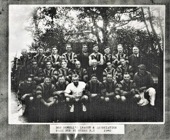
Photograph, Bob Powell's League & Association, Fags for Fighters Football Club 1940, 1940
... Centre row from left - Ian JOHNSON ( Australian Cricket Captain), Austin ROBERTSON(South/Port), Laurie NASH ( South/Camberwell), Syd COVENTRY ( Collingwood), Bob POWELL (South official), Herbie MATTHEWS ( South/Oakleigh), Charlie RICHES (Port). Front row from left - unknown except for 2nd from left Hugh McLAUGHLIN (South)....Includes players from Port & South Melbourne, South/Camberwell, South Oakleigh & Collingwood. Bob Powell was a well know proprietor of the Railway Club Hotel in Ferrars Street, South Melbourne. ...Includes players from Port & South Melbourne, South/Camberwell, South Oakleigh & Collingwood. Bob Powell was a well know proprietor of the Railway Club Hotel in Ferrars Street, South Melbourne. ...From the collection of Terry KEENAN.Back Row from left -Tom LAHIFF (Port), George BARNETT (Port), Jack WILLIAMS (South) , Ron REYNOLDS (Port), CHIEF LITTLE WOLF (American wrestler), Norm FLETCHER (Port), ?, ?, Roy KENT (Port official). Centre row from left - Ian JOHNSON ( Australian Cricket Captain), Austin ROBERTSON(South/Port), Laurie NASH ( South/Camberwell), Syd COVENTRY ( Collingwood), Bob POWELL (South official), Herbie MATTHEWS ( South/Oakleigh), Charlie RICHES (Port). Front row from left - unknown except for 2nd from left Hugh McLAUGHLIN (South).Black and white photocopy of Bob Powell's League & Association Fags for Fighters Football Club team 1940. Includes players from Port & South Melbourne, South/Camberwell, South Oakleigh & Collingwood. Bob Powell was a well know proprietor of the Railway Club Hotel in Ferrars Street, South Melbourne. Fags for Fighters was a fund raising organisation to provide funds for troops overseas.sport - australian rules football, fags for fighters football club, bob powell's league & association, george barnett, jack williams, ron reynolds, chief little wolf, norm fletcher, roy kent, ian johnson, austin robertson, laurie nash, syd coventry, bob powell, herbie matthews, charlie riches, hugh mclaughlin, tommy lahiff -
 Bendigo Historical Society Inc.
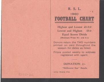
Document - R.S.L. BENDIGO COLLECTION: R.S.L. 1960 FOOTBALL CHART
... ... South Melbourne... Oakleigh...The Football clubs are: Melbourne, Sunshine, Geelong, Preston, Fitzroy, Box Hill, Richmond, Yarraville, South Melbourne, Oakleigh, St. Kilda, Brunswick, Hawthorn, Sandringham, Collingwood, Brighton, Footscray, Northcote, Moorabbin, Essendon, Coburg, North Melbourne, Camberwell, Carlton, Williamstown, Port Melbourne, Dandenong and Mordialloc....Bendigo Collection - R.S.L. 1960 Football Chart Melbourne Sun Arthur Hocking Print Melbourne Sunshine Geelong Preston Fitzroy Box Hill Richmond Yarraville South Melbourne Oakleigh St. Kilda Brunswick Hawthorn Sandringham Collingwood Brighton Footscray Northcote Moorabbin Essendon Coburg North Melbourne Camberwell Carlton Williamstown Port Melbourne Dandenong Mordialloc Arthyr Hocking Print. ...Orange card titled R.S.L. 1960 Football Chart. On the front is how it works. Donation 2/-. Melbourne Sun Results. Printed by Arthur Hocking Print. On the other side is the list of the teams and the dates from 16/4/60 to 20/8/60. The Football clubs are: Melbourne, Sunshine, Geelong, Preston, Fitzroy, Box Hill, Richmond, Yarraville, South Melbourne, Oakleigh, St. Kilda, Brunswick, Hawthorn, Sandringham, Collingwood, Brighton, Footscray, Northcote, Moorabbin, Essendon, Coburg, North Melbourne, Camberwell, Carlton, Williamstown, Port Melbourne, Dandenong and Mordialloc.Arthyr Hocking Print.clubs and associations, football, football chart, r.s.l. bendigo collection - r.s.l. 1960 football chart, melbourne sun, arthur hocking print, melbourne, sunshine, geelong, preston, fitzroy, box hill, richmond, yarraville, south melbourne, oakleigh, st. kilda, brunswick, hawthorn, sandringham, collingwood, brighton, footscray, northcote, moorabbin, essendon, coburg, north melbourne, camberwell, carlton, williamstown, port melbourne, dandenong, mordialloc -
Glen Eira Historical Society
Book - MOORABBIN
... ... South Oakleigh...It has been produced by the City Council in 1987 Directories City of Moorabbin Sports and Recreations Establishment Clubs Local Government Clubs and Associations Sport and Recreation Service Clubs Businesses Sporting Social Services Social Clubs Community Services Community Centres Community Groups Community Organisations East Ormond South Oakleigh Moorabbin Patterson McKinnon Ormond Bentleigh Bentleigh East Book MOORABBIN ...One item about Moorabbin: 1/An A4 directory of services, clubs, organisations, amenities, sport and recreation facilities, and associations within the Moorabbin City Council’s locality. It has been produced by the City Council in 1987directories, city of moorabbin, sports and recreations, establishment, clubs, local government, clubs and associations, sport and recreation, service clubs, businesses, sporting, social services, social clubs, community services, community centres, community groups, community organisations, east ormond, south oakleigh, moorabbin, patterson, mckinnon, ormond, bentleigh, bentleigh east -
Glen Eira Historical Society
Document - St. Christopher’s Anglican Church, Bentleigh East
... ... South Oakleigh Uniting Church...Brady Road Church of Christ Brooker Burne East Boundary Road North Road Bignell Road South Oakleigh Uniting Church St. Peter’s Catholic Church East Boundary Road Uniting Church Kenny Charles Rev. ...4 items: 1/Three parish newsletters dated May 1957 and December 1959, and Christmas 1959, and undated. Newsletter about fundraising for new church building completed in 1969. 2/Three Christmas church service details for 1979, 1984, one undated and one for 09/05/2010. 3/Photocopy of booklet dated 1977 celebrating 25 years of the church and list of invitees and 2002 celebration of fifty years of the church and order of service dated 08/09/2002, and photocopy of recollections, handwritten, by Mrs. Iris Fowler in 2002 of her years as a parishioner. 4/Two pages of names of St. Christopher’s Pioneers, handwritten, dated 24/07/2012 by Clare Barton. Newsletters all contain lists of officials and various parishioners, and advertisements by local businesses, and lists of all ministers and curates.st. christopher’s church of england, centre road, mackie road, bentleigh east, chambers david h. rev., green laurie v. rev., st. john’s church of england, glasscock geoffrey t. rev., brady road church of christ, brooker burne, east boundary road, north road, bignell road, south oakleigh uniting church, st. peter’s catholic church, east boundary road uniting church, kenny charles rev., cecil street, cottier john rev., poole tony, churches, anglican church, church services, church festivals, christmas, sunday schools -
 City of Kingston
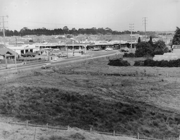
Photograph - Black and white, c. 1963
... Black and white photograph of the intersection of Warrigal Road and Centre Road, South Oakleigh, viewed from the reservoir. In the foreground are paddocks and in the background is a shopping strip, including a petrol station....Oakleigh Roads Shopping strip Paddocks Handwritten in blue ink on reverse: 2196 Handwritten in red ink on reverse: 100% Black and white photograph of the intersection of Warrigal Road and Centre Road, South Oakleigh, viewed from the reservoir. In the foreground are paddocks and in the background is a shopping strip, including a petrol station. ...This image depicts the intersection of increasing urbanisation and the rural landscape that once made up the area now known as City of Kingston.Black and white photograph of the intersection of Warrigal Road and Centre Road, South Oakleigh, viewed from the reservoir. In the foreground are paddocks and in the background is a shopping strip, including a petrol station.Handwritten in blue ink on reverse: 2196 Handwritten in red ink on reverse: 100%oakleigh, roads, shopping strip, paddocks -
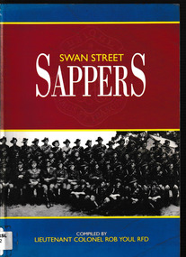 Monbulk RSL Sub Branch
Book, Headquarters Logistic Support Force Engineers committee, The Swan Street Sappers 1860-1996 : a history of the Engineer Training Depot, Swan Street, Melbourne and of Sappers in Victoria, 1995
... Oakleigh South, Victoria, Australia ...This book marks the closing of the Engineer Training Depot at Swan Street, Melbourne in late 1991 by registering its great contribution to military and community life and by telling the story of Sappers in Victoria.Index, bib, ill, p.203.non-fictionThis book marks the closing of the Engineer Training Depot at Swan Street, Melbourne in late 1991 by registering its great contribution to military and community life and by telling the story of Sappers in Victoria.australian army - history, australian army - engineers -
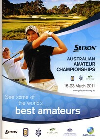 Heidelberg Golf Club
Booklet, Golf Australia, Australian Amateur Championships 16-23 April 2011, 2011
... Played at Woodlands Golf Club (Mordialloc), Huntingdale Golf Club (South Oakleigh) and Victoria Golf Club (Cheltenham)....Played at Woodlands Golf Club (Mordialloc), Huntingdale Golf Club (South Oakleigh) and Victoria Golf Club (Cheltenham). ...Official guide to Australian Amateur Championships 16-23 April 2011. Played at Woodlands Golf Club (Mordialloc), Huntingdale Golf Club (South Oakleigh) and Victoria Golf Club (Cheltenham).Bruce Harding is a past HGC President and involved with Victoria's Junior teams, and as a rules official and referee.40p., illus. (some col.). Booklet accompanied by Conditions of competition and rules.bruce harding, australian amateur championships -
Glen Eira Historical Society
Article - Rosstown Railway
... Oakleigh Road... Rosanna Street... Murrumbeena Crescent... North Road... Kooyong Road... Hawthorn Road... Booran Road... Koornang Road... Poath Road... Warragul Road... Railway Platforms... Railway Buildings... Bambra Road... Swamps... Landforms... Landfill... Council Landfill... Railway Bridges... Bridges... Railway Underpasses... Sporting Clubs... Tennis Clubs... Bowls Clubs... Rosstown Railway... Rosanna Street Reserve... Maps... Railway Maps... LIVING IN GLEN EIRA... Weickhardt Ian... Jowett Des... Caulfield South...Murray Ross Murray Sugar Beet Mills Mills Elsternwick Land Transport Railways Railway Lines Railway Routes Carnegie Neville Street Carnegie Miller Street Factories Market Gardens Horticulture Peat Soils Land Forms Topography Geology Civic Issues Cone Sugar Industry Elsternwick Plaza Elsternwick Glenhuntly Road Parks and Reserves EE Gunn Reserve Caulfield Racecourse Sportsgrounds Caulfield Carnegie Riddell Parade Clarence Street Aileen Avenue Princes Park Dover Street Marara Road Oakleigh Road Rosanna Street Murrumbeena Crescent North Road Kooyong Road Hawthorn Road Booran Road Koornang Road Poath Road Warragul Road Railway Platforms Railway Buildings Bambra Road Swamps Landforms Landfill Council Landfill Railway Bridges Bridges Railway Underpasses Sporting Clubs Tennis Clubs Bowls Clubs Rosstown Railway Rosanna Street Reserve Maps Railway Maps LIVING IN GLEN EIRA Weickhardt Ian Jowett Des Caulfield South Curraweena Road Oakleigh Caulfield Technical School RETURN TO ROSSTOWN Beet Sugar Industry Crops Land Booms Land Development and Subdivisions Bent Thomas Fink Benjamin Sugar Works Rosstown Hotel Oamdenong Road ROSSTOWN DRY CLEANERS Shops Rosstown Road Rosstown Plate People by Circumstance Migrants Accountants Occupations Professionals THE GRANGE Real Estate Grange Road Financial Agents Judges ROSSTOWN ESTATE Financial Trouble Rabbit Preserving Breweries Political Debates Political Issues Political Electorates Politics Political Science Debt Financial Loans Court Procedures Court Cases Legal Events and Activities MALLESON AND RIGGALL Widowers SEABEACH RAILWAY Economics Economic Deadline Depression 1890s Economic Crash Mortgages Divorce Social Problems Poverty Ross Claude Ross Roderick World War 1914-1918 Wars Military History Servicemen AUSTRALIAN FLYING CORPS Engineers Caulfield Council Swagmen Homelessness Glenhuntly Road Glenhuntly Road Tram Woornack Road Leila Road Wild Cherry Road Melten Avenue Illustrations Steam Trains Trains Horse and Cart Horse-drawn Transport Railway Stations Article Rosstown Railway ...This file contains three items: 1/A review of the ROSSTOWN RAIL TRAIL from LIVING IN GLEN EIRA, vol. 11, 2004, Issue 4, no. 25, date and author unknown. The review explains the purpose of the Rail Trail with a brief narrative of the history behind Rosstown Sugar Mill Railway line. Concluding with information on the location of the Trail and the expected time required to walk the entire track included in the review is a map of the Rail Trail, which marks significant sites along the trail with historic pictures. 2/A newspaper article from THE AGE, dated Tuesday 21/10/1980 and written by Iola Matthews, reporting on the circumstances that led to the publication of the book RETURN TO ROSSTOWN written by Des Jowett and Ian Weickhardt. The article begins with a brief biography of the authors before moving into details of the book’s content, providing a further biography of W. Murray Ross which includes information on his financial ventures – particularly the Rosstown Rail – his marriage and children. The article includes a black and white photograph of Weickhardt and Jowett walking along the route of the railway line, an illustration of the Rosstown sugar works and a map of the area surrounding the site of the mill. 3/Three photocopies of a black and white illustration of the Rosstown sugar works from the east, undated and artist unknown.rosstown rail trail, rosstown, ross william, ross w. murray, ross murray, sugar beet mills, mills, elsternwick, land transport, railways, railway lines, railway routes, carnegie neville street, carnegie miller street, factories, market gardens, horticulture, peat, soils, land forms, topography, geology, civic issues, cone sugar industry, elsternwick plaza, elsternwick, glenhuntly road, parks and reserves, ee gunn reserve, caulfield racecourse, sportsgrounds, caulfield, carnegie, riddell parade, clarence street, aileen avenue, princes park, dover street, marara road, oakleigh road, rosanna street, murrumbeena crescent, north road, kooyong road, hawthorn road, booran road, koornang road, poath road, warragul road, railway platforms, railway buildings, bambra road, swamps, landforms, landfill, council landfill, railway bridges, bridges, railway underpasses, sporting clubs, tennis clubs, bowls clubs, rosstown railway, rosanna street reserve, maps, railway maps, living in glen eira, weickhardt ian, jowett des, caulfield south, curraweena road, oakleigh, caulfield technical school, return to rosstown, beet sugar industry, crops, land booms, land development and subdivisions, bent thomas, fink benjamin, sugar works, rosstown hotel, oamdenong road, rosstown dry cleaners, shops, rosstown road, rosstown plate, people by circumstance, migrants, accountants, occupations, professionals, the grange, real estate, grange road, financial agents, judges, rosstown estate, financial trouble, rabbit preserving, breweries, political debates, political issues, political electorates, politics, political science, debt, financial loans, court procedures, court cases, legal events and activities, malleson and riggall, widowers, seabeach railway, economics, economic deadline, depression 1890s, economic crash, mortgages, divorce, social problems, poverty, ross claude, ross roderick, world war 1914-1918, wars, military history, servicemen, australian flying corps, engineers, caulfield council, swagmen, homelessness, glenhuntly road, glenhuntly road tram, woornack road, leila road, wild cherry road, melten avenue, illustrations, steam trains, trains, horse and cart, horse-drawn transport, railway stations -
Glen Eira Historical Society
Document - St. Anthony’s School, Glen Huntly
... ... Oakleigh South Bunnings...Anthony’s School Glenhuntly Catholic School Primary School Advertisement Newspaper Teacher Community Garden Rawson Jordan Oakleigh South Bunnings Little Veggie Patch Bendigo Community Bank Caulfield Document St. ...This file Contains three items from the Caulfield Leader. Two enrolment advertisements dated 08/03/2011 and 06/03/2012 for St. Anthony’s School Glenhuntly – includes facilities and programs. A newspaper cutting dated 29/03/2011 – includes photograph with caption from St. Anthony’s School re a vegetable garden project.st. anthony’s school glenhuntly, catholic school, primary school, advertisement, newspaper, teacher, community garden, rawson jordan, oakleigh south bunnings, little veggie patch, bendigo community bank caulfield -
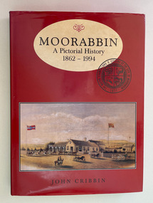 City of Moorabbin Historical Society (Operating the Box Cottage Museum)
Book, Cribbin, John, Moorabbin : a pictorial history 1862-1994, 1995
... South...Benteligh...Bentleigh East...Heatherton...Oakleigh...City of Moorabbin Historical Society (Operating the Box Cottage Museum) Joyce Park Jasper Road Ormond melbourne moorabbin city of Moorabbin McKinnon Ormond South Benteligh Bentleigh East Heatherton Oakleigh South Highett Cheltenham Moorabbin: A Pictorial History is about a city that was. ...Moorabbin: A Pictorial History is about a city that was. The book traces the story of Moorabbin for its beginnings to its end in 1994, from inside coverix, 214 p. : col. ill., ports.non-fiction Moorabbin: A Pictorial History is about a city that was. The book traces the story of Moorabbin for its beginnings to its end in 1994, from inside covermoorabbin, city of moorabbin, mckinnon, ormond south, benteligh, bentleigh east, heatherton, oakleigh south, highett, cheltenham -
Whitehorse Historical Society Inc.
Map, Waverley, c1985
... Map of Waverley, including Box Hill Soiuth, Blackburn South, Vermont, Vermont South, Burwood East, Burwood, Ashburton, Mount Waverley, Glen Waverley, Oakleigh South, Clayton North and Mulgrave. ...Map of Waverley, including Box Hill Soiuth, Blackburn South, Vermont, Vermont South, Burwood East, Burwood, Ashburton, Mount Waverley, Glen Waverley, Oakleigh South, Clayton North and Mulgrave. ...Map of Waverley, including Box Hill Soiuth, Blackburn South, Vermont, Vermont South, Burwood East, Burwood, Ashburton, Mount Waverley, Glen Waverley, Oakleigh South, Clayton North and Mulgrave.Map of Waverley, including Box Hill Soiuth, Blackburn South, Vermont, Vermont South, Burwood East, Burwood, Ashburton, Mount Waverley, Glen Waverley, Oakleigh South, Clayton North and Mulgrave. UBD map issued by Nicholls Gledhill Real Estate Agents. Scale 1:50,000.Map of Waverley, including Box Hill Soiuth, Blackburn South, Vermont, Vermont South, Burwood East, Burwood, Ashburton, Mount Waverley, Glen Waverley, Oakleigh South, Clayton North and Mulgrave. blackburn south, burwood east, vermont, vermont south, forest hill -
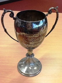 NMIT (Northern Melbourne Institute of TAFE)
Trophy: Collingwood Technical School 1933, Boomerang Plate, Silver trophy from Victorian Technical Schools Sports Union 1933
... METROPOLITAN DISTRICT / of the / Victorian Technical Schools Sports Union / CHAMPIONSHIP CUP / for the school winning the greatest number of events / at the / ANNUAL BOXING CHAMPIONSHIPS / Presented by the Victorian Amateur Boxing & Wrestling Assn / 1933’ On back is a list of winners from 1933 to 1950 includes Brighton, Prahran, South Melbourne, Essendon, Oakleigh, Brunswick. ...NMIT (Northern Melbourne Institute of TAFE) Collingwood Technical School Trophies Boxing Championship trophy 1933 Students NMIT METROPOLITAN DISTRICT / of the / Victorian Technical Schools Sports Union / CHAMPIONSHIP CUP / for the school winning the greatest number of events / at the / ANNUAL BOXING CHAMPIONSHIPS / Presented by the Victorian Amateur Boxing & Wrestling Assn / 1933’ On back is a list of winners from 1933 to 1950 includes Brighton, Prahran, South Melbourne, Essendon, Oakleigh, Brunswick. Silver cup trophy from the Victorian Amateur Boxing & Wrestling Association for the Annual Boxing Championships won by Collingwood Technical School in 1933. ...Silver cup trophy from the Victorian Amateur Boxing & Wrestling Association for the Annual Boxing Championships won by Collingwood Technical School in 1933. Also won by Collingwood in 1934, 1939, 1942, 1943, 1944, 1945, 1946, 1947. METROPOLITAN DISTRICT / of the / Victorian Technical Schools Sports Union / CHAMPIONSHIP CUP / for the school winning the greatest number of events / at the / ANNUAL BOXING CHAMPIONSHIPS / Presented by the Victorian Amateur Boxing & Wrestling Assn / 1933’ On back is a list of winners from 1933 to 1950 includes Brighton, Prahran, South Melbourne, Essendon, Oakleigh, Brunswick. collingwood technical school, trophies, boxing championship trophy 1933, students, nmit, -
 Torquay and District Historical Society
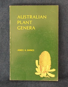
Book, Baines, James A, Australian plant genera, 1981
... His last positions were as principal at Ringwood, Oakleigh South and Clayton North. In 1976 he moved back to Torquay. ...His last positions were as principal at Ringwood, Oakleigh South and Clayton North. In 1976 he moved back to Torquay. ...Paperback book with green and yellow cover, 406 pages. There is also an index card with handwritten information about RHODOMYRTUS (Myrtaceae) on both sides.non-fictionjames baines -
 Torquay and District Historical Society
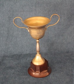
Award - Trophy, 1940
... His last positions were as principal at Ringwood, Oakleigh South and Clayton North. In 1976 he moved back to Torquay. ...His last positions were as principal at Ringwood, Oakleigh South and Clayton North. In 1976 he moved back to Torquay. ...Trophy awarded to James Baines by Torquay Table Tennis Club in 1940. James Austin Baines was a teacher, school principal and author. He moved to Torquay in 1937 with his wife Ray and took up a position as head teacher at the primary school. In 1942 the family moved to Melbourne where he taught for over 30 years in State primary schools. His last positions were as principal at Ringwood, Oakleigh South and Clayton North. In 1976 he moved back to Torquay. His book "Australian plant genera" was published in 1981. For further information about him see https://torquayhistoricalsociety.com.au/james-austin-baines/Small silver cup with bakelite baseHosford Cup // Torquay TTC // JA Baines // 11-7-40trophy, award, james baines -
 Torquay and District Historical Society
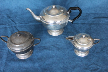
Domestic object - Silver tea set
... His last positions were as principal at Ringwood, Oakleigh South and Clayton North. In 1976 he moved back to Torquay. ...His last positions were as principal at Ringwood, Oakleigh South and Clayton North. In 1976 he moved back to Torquay. ...This tea set was presented to Mr and Mrs Baines in appreciation from friends at Notting Hill in 1947. James (Jim) Baines was a teacher, school principal and author. He moved to Torquay in 1937 with his wife Ray and took up a position as head teacher at the primary school. In 1942 the family moved to Melbourne where he taught for over 30 years in State primary schools. His last positions were as principal at Ringwood, Oakleigh South and Clayton North. In 1976 he moved back to Torquay. Jim was the author of a handwritten history of Torquay as well as of schools in the Monash Inspectorate, and the book "Australian plant genera", published in 1981. See https://torquayhistoricalsociety.com.au/james-austin-baines/ for further information about him.Silver three piece tea set consisting of teapot with black handle, covered two handled sugar bowl and covered milk jugInscribed on side of teapot "presented to Mr and Mrs Baines in appreciation from friends at Notting Hill 27-8-47"james baines -
4th/19th Prince of Wales's Light Horse Regiment Unit History Room
Medal
... Oakleigh, Victoria aged 15. A member of the Victorian permanent forces, he served as a corporal (regimental number 8) with the First Victorian Mounted Infantry Company, part of the first Victorian Contingent to the war in South Africa in 1899. ...Oakleigh, Victoria aged 15. A member of the Victorian permanent forces, he served as a corporal (regimental number 8) with the First Victorian Mounted Infantry Company, part of the first Victorian Contingent to the war in South Africa in 1899. ...Title Peace of 1919 medalet issued to Australian schoolchildren Object type Medalet Place made Australia: Victoria, Melbourne Date made 1919 Summary Designed by C Douglas Richardson, 'The Peace of 1919' medalet was issued by the Defence Department to school children throughout Australia to commemorate the signing of the Versailles Peace Treaty in 1919. The medals were originally suspended from a narrow piece of red, white and blue striped cotton ribbon. This medalet is associated with one of the children of Lance Corporal Giles Daniel, 1st AIF. Born in Ballarat, western Victoria on 16 December 1870, Giles Felix Daniel moved to Oakleigh, Victoria aged 15. A member of the Victorian permanent forces, he served as a corporal (regimental number 8) with the First Victorian Mounted Infantry Company, part of the first Victorian Contingent to the war in South Africa in 1899. This unit was one of the first Australian formations to see action during the Boer War. It was largely drawn from serving members of the Victorian forces. Demoted to private following a Court Martial on 19 November 1900, Daniel returned to Australia in December of the same year. During the First World War, he was again one of the first to enlist, joining the AIF on 19 August 1914, and becoming Lance Corporal number 32 with the First Divisional Signals Company. He served with this unit during the Gallipoli campaign and until his return to Australia on 11 April 1916. Silver-plated brass Circular medalet with a plain edge and integral suspension loop. The obverse features a symbolic female figure of Peace, holding a sword and standing on a plinth marked 'PEACE 1919'. Behind her flies a dove, and at her left and right feet are two figures freed from their shackles. The reverse features a central panel surrounded by laurel leaves, surmounted by the King's Crown with the word 'VICTORY' over the rays of the rising sun. A sailor and a digger stand at ease on either side of the panel on which is cast 'THE / TRIUMPH / OF / LIBERTY / AND / JUSTICE'. Below the leaves is a very small panel with the words 'THE PEACE OF 1919' and the manufacturer's name.peace medal 1919 -
 Glen Eira Historical Society
Letter - Rosstown Railway
... South... Calder G.K.... Calder G.... Hawthorn Road... Glen Eira Road... Ballantyne R.... Office Workers... CAULFIELD CONTACT... Norman Peter... Groups... Glen Huntly... Koornang Road... Mills... Sugar Mills... Caulfield Historical Society... Caulfield City Council... Caulfield Town Hall... Official Buildings... Glen Huntly Neville Street Fourteen... Parliamentary Representatives... Rosstown... Rosstown Railway... Rosstown Railway Centenary... Festivals and Celebrations... Centenaries... Historical Markers... Plaques... Monuments and Memorials... Ross Murray... Railways... Land Transport... Curraweena Road... Parts of Buildings or Structures... Bluestone Structures... Construction Materials... Caulfield Community Liaison Officer... Harry Carol... Currency... Finances... Onley Peter... Elsternwick... Oakleigh...South Calder G.K. Calder G. Hawthorn Road Glen Eira Road Ballantyne R. Office Workers CAULFIELD CONTACT Norman Peter Groups Glen Huntly Koornang Road Mills Sugar Mills Caulfield Historical Society Caulfield City Council Caulfield Town Hall Official Buildings Glen Huntly Neville Street Fourteen Parliamentary Representatives Rosstown Rosstown Railway Rosstown Railway Centenary Festivals and Celebrations Centenaries Historical Markers Plaques Monuments and Memorials Ross Murray Railways Land Transport Curraweena Road Parts of Buildings or Structures Bluestone Structures Construction Materials Caulfield Community Liaison Officer Harry Carol Currency Finances Onley Peter Elsternwick Oakleigh Council Meetings Caulfield Council Chambers Caulfield Municipal Chambers Caulfield Municipal Offices Craig A. ...This file contains two items: 1/A group of eight letters, predominantly between Hon. Secretary of Caulfield Historical Society R. Ballantyne and members of the Caulfield City Council written between 1981 and 1983, regarding the installation of a plaque in commemoration of the centenary of the Rosstown Railway. The first two letters are handwritten from R. Ballantyne to G. Calder and Carol Camy, dated 01/06/1981 and 22/02/1982. The letter to G. Calder supports a suggestion in the May edition of the CAULFIELD CONTACT for the installation of a plaque in celebration of the centenary of the Rosstown Railway, suggesting a potential site for another plaque on Curraweena Road. The letter to Carol Harry discusses the costing of the plague and a possible contribution towards this cost from the Caulfield Historical Society. The letter appears to be incomplete, having no sign off from the author. Attached to the letter is what appears to be a suggestion for the inscription of the plaque. The letters addressed to R. Ballantyne are typed and dated 12/06/1981, 24/06/1981, 14/07/19891, 17/12/1981 and 08/09/1983, from A. Craig and D.B. Hogan on behalf of City Manager G.K. Calder and City Liason Officer Carol Harry. All letters concern the commemorative plaque, with these from Carol Harry including handwritten notes which appear to be in R. Ballantyne’s handwriting. The final letter is from Mayoral Secretary Norma Polglase to Miss B. Snowball, dated 23/08/1983, inviting her to attend the unveiling of the plaque. Also included in the item are Council Committee Meeting minutes, dated 16/05/1981, broaching the subject of installing the plaque in Koornang Road. 2/Four colour photographs and two black and white copies of one of the photographs, all dated 18/09/1983 and showing the opening of the commemorative plaque in Marrara Gardens. Two photographs picture Mayor Brian Rudski and City Manager Graham Calder with a crowd of unidentified people present. One photograph and both copies are of the inscription on the plaque, with the wording identical to that of the handwritten note by R. Ballantyne, in item one.caulfield, caulfield south, calder g.k., calder g., hawthorn road, glen eira road, ballantyne r., office workers, caulfield contact, norman peter, groups, glen huntly, koornang road, mills, sugar mills, caulfield historical society, caulfield city council, caulfield town hall, official buildings, glen huntly neville street fourteen, parliamentary representatives, rosstown, rosstown railway, rosstown railway centenary, festivals and celebrations, centenaries, historical markers, plaques, monuments and memorials, ross murray, railways, land transport, curraweena road, parts of buildings or structures, bluestone structures, construction materials, caulfield community liaison officer, harry carol, currency, finances, onley peter, elsternwick, oakleigh, council meetings, caulfield council chambers, caulfield municipal chambers, caulfield municipal offices, craig a., caulfield city manager, city of caulfield, caulfield physical environment committee, public meetings, meetings, ross james, hogan o.b., arrow engraving, campbell f., snowball miss., elsternwick gladstone parade nineteen, walters w.r., marara road gardens, marara road, marara gardens, narrawong road, ceremonies, caulfield mayors, polglase norma, mayoral secretaries, railways routes, documents, correspondence, rudski brian, calder graham, events and activities, official buildings, insignia, local government, local officials and employees, parks and reserves, buildings structures and establishments, official events, festivals and celebrations, occupations, political processes, local history, history, financial economics, local government finance -
Glen Eira Historical Society
Letter - Rosstown Railway
... Oakleigh Railway Company Limited... Cameron W.C.... Phillips P.D.... Garden Vale... Elsternwick... Elsternwick Railway Station... Rosstown... Rosstown Railway... Thomas Street... Bay Street... Kooyong Road... Melbourne and Brighton Railway... Hawthorn Road... Bambra Road... Caulfield and Frankston Railway... Booran Road... Grange Road... Koornang Road... Murrumbeena Road... North Road... North Road Railway Station... East Brighton Railway Station... South...Oakleigh Railway Company Limited Cameron W.C. Phillips P.D. Garden Vale Elsternwick Elsternwick Railway Station Rosstown Rosstown Railway Thomas Street Bay Street Kooyong Road Melbourne and Brighton Railway Hawthorn Road Bambra Road Caulfield and Frankston Railway Booran Road Grange Road Koornang Road Murrumbeena Road North Road North Road Railway Station East Brighton Railway Station South Road Railway Routes Railway Lines Railways Land Transport Murphy J. ...This file contains four items: 1/A black and white photocopy of a letter dated either 07/08/1889 or 09/08/1889, from Robert Lundon to an unidentified recipient discussing an agreement reached between the author – on behalf of the recipient – and Soon Hang Hi in regard, in regards to the allotment known as Webber’s. The agreement is outlined in the letter in what appears to be Chinese characters, and includes the marks of Robert Lundon and Soon Hang Hi. File note from Joy Wu states that the calligraphy is not Mandarin or traditional Chinese. 2/Three sheets of hand-written working notes with information taken from the Victorian Government Gazette on THE ROSSTOWN AND MURRUMBEENA LAND COMPANY LIMITED, THE ROSSTOWN JUNCTION RAILWAY AND PROSPERITY COMPANY LIOMITED, and THE ROSSTOWN JUNCTION, ELSTERNWICK, AND OAKLEIGH RAILWAY COMPANY LIMITED, covering dates between 1887 and 1894. The notes concern meetings and creditors claims relevant to the companies, with reference numbers for the information source. Date and author of the notes are not recorded. 3/A black and white photocopy of the a partial map of the Rosstown Railway and surrounding area, undated. The map includes the names of landholders in the areas of Brighton, Garden Vale and Elsternwick, as well as other railway lines present in the region. 4/A fold-out map and guide of the Rosstown Rail Trail, including a brief general history of Caulfield as well as a more extensive biography of William Murray Ross and the Rosstown Railway. The map marks and describes significant sites along the trail, including photographs of some of these sites, provided by DF Jowett.documents, correspondence, webber’s, lundon robert, chinese characters, ethnic communities, signatures, text, settlements, taxes, fraser john grieves, lovell r.h., price davies, meetings, communication activities, soon hang hi, commercial events and activities, the rosstown and murrumbeena land company limited, victorian government gazette, bulmer richard, parry john, osment henry, shareholders, creditors claims, the rosstown junction railway and property company limited, finch and best, lawyers, the rosstown junction elsternwick and oakleigh railway company limited, cameron w.c., phillips p.d., garden vale, elsternwick, elsternwick railway station, rosstown, rosstown railway, thomas street, bay street, kooyong road, melbourne and brighton railway, hawthorn road, bambra road, caulfield and frankston railway, booran road, grange road, koornang road, murrumbeena road, north road, north road railway station, east brighton railway station, south road, railway routes, railway lines, railways, land transport, murphy j., caulfield, hamilton t.f., dane p., holloway, webb, ailee john, payne t.b., brodie chas, dane john, o’neil h., mccombie john, mcmillane a., smyth c.d., cooper, ebden, landholders, jeffrey j.d., gill j., balcombe a.e., cooper h., mcnab j., white j., sutherland j., greeves a.f.a., newton m.c., chamley f.b., fowler j., inglis p., grant t., stooke j., swanson g., cochrane c., adams e.b., mccombie thas, keyes robert, brighton cemetery, burials grounds and graveyards, war-ein road, were j.b., holland j., mcmahon c., winter t.l.m., dendy henry, mitchell w., jackson s., were j.e., wickham francis dawe, bryant jane, east brighton railway station, railway stations, maps, allotments, land titles, roads and streets, rosstown rail trail, city of glen eira, tourism, trains, tourism information bureaus, tours, pamphlets, elsternwick railway park, oakleigh junction, princes park, ee gunn reserve, packer park, sites, jowett d.f., weickhardt i.g., return to rosstown: railways land sales and sugar beet ventures in caulfield, land sales, walking trails, ross william murray, transport objects, locomotion, walking, cycling, driving, sports, country mansions, people, caulfield john, builders, construction and demolition workers, occupations, careers, professionals, topography, geology, landforms, horticulture, market gardens, primary industry workers, city of caulfield, mood kee, pennington harold, annual general meetings, caulfield town hall, glen eira city council, carnegie, carnegie station, rosstown station, people by circumstance, migrants, sugar beet, sugar beet mill, sugar beet industry, mills, factories, sea beach lines, bent thomas, parliamentary representatives, neville street, miller street, lemann’s swamp reserve, koornang park, cane sugar industry, breweries, rabbit processing plants, health establishments, hospitals, food production establishments, abattoirs, thieves, social problems, vagrants, theft, squatting, financial economics, debt, finance industry, insurance companies, company managers, bentleigh, ross leila, the grange, leila road, wild cherry road, financial trouble, mortgages, gisborne street, archibald street, riddell parade, victoria railways, glen huntly road, clarence street, college street, gladstone parade, parrell street, aileen avenue, seaview street, land subdivisions, dover street, sussex street, landfill, marara road, booran road, woodville avenue, dorothy avenue, ormond park, royal avenue, ormond railway station, oakleigh road, melten avenue, miller street, munro avenue, lord reserve, neerim road, toolambool road, the rosstown hotel, rosanna street, murrumbeena crescent, commercial establishments, the national bank, rosstown road, kangaroo road, poath road, freda street, hughesdale kindergarten, oakleigh council, hughesdale community centre, civic establishments, galbally reserve, plaques, warrigal road, out and about brochures, orion estate -
Glen Eira Historical Society
Newspaper - GLENHUNTLY
... South Primary School... Gardenvale Central Primary School... Norman Peter... Rubbish bins... Koornang Road Shopping Centre... Carnegie Neighbourhood Study... Car Parks... Caulfield City Council... Homestead Handyman Hardware... Hardware Stores... Liberal Party... Railway Crossings... North Road... Ormond Railway Station... Strong Chris Mr.... Kendall Press... Norman Carol... Ormond East Primary School... Norman Stuart... Norman Cameron... Estrella Kindergarten... Solway Primary School... Higgins Electorate Committee... Higgins Area Finance Committee... National Stationers and Office Suppliers Association... Oakleigh...‘Glenhuntly News’ Glenhuntly Primary School Primary Schools Fires Dolphin Bill St Anthony’s School Dalton Des Caulfield South Primary School Gardenvale Central Primary School Norman Peter Rubbish bins Koornang Road Shopping Centre Carnegie Neighbourhood Study Car Parks Caulfield City Council Homestead Handyman Hardware Hardware Stores Liberal Party Railway Crossings North Road Ormond Railway Station Strong Chris Mr. Kendall Press Norman Carol Ormond East Primary School Norman Stuart Norman Cameron Estrella Kindergarten Solway Primary School Higgins Electorate Committee Higgins Area Finance Committee National Stationers and Office Suppliers Association Oakleigh Chamber of Commerce Anti-C3 Action Group (ACTAG) Haywood Don Ireland Jim Ramsay Jim Gardner Barry Sessler Kurt Thompson Lindsay Booran Holden Glenhuntly Road Caulfield Newspaper GLENHUNTLY ...This file contains one item pertaining to Glenhuntly: 1/A copy of the 11/1981, Vol. 1, No. 1 edition (that is, the first edition) of the Glenhuntly News, a local newspaper. Each of its 8 pages except pages 6 and 8 contain material of relevance to Glen Eira. Page 1 features 3 items: an article about the action taken in the wake of a fire occurring at Glenhuntly Primary School on 29/10/1981, a short article about Caulfield resident’s misuse of rubbish bins, and an article (continued on page 7) about the beautification of the Koornang Road Shopping Centre. Page 2 features 2 items: an advertisement for Homestead Handyman Hardware, and an article in which the Liberal candidate for the seat of Glenhuntly, Peter Norman, comments on the State Government’s decision not to extend trading hours for large retailer. Page 3 features 4 items: 2 advertisements for volunteer work for the regional branch of the Liberal Party, an article about the many difficulties people face using an underpass at a railway crossing in North Road, and an article describing the aims of the newly-established newspaper itself. Pages 4 and 5 feature 1 item: an article about Peter Norman; his life, work and opinions. Page 6 features 1 item: an article(continued on page 7) by three American children – Anita, Fabos and Adrian (surnames unspecified) – detailing their visit to Melbourne. There does not appear to be anything of relevance to Glen Eira. Page 7 features 5 items: the continuations of the articles from pages 1 and 6, an advertisement for a pool party for young Caulfield/Glenhuntly Liberals, an advertisement for an antiques sale, and an article about the establishment of a technical school on the site of former Holmesglen Construction Factory in Malvern (not relevant to Glen Eira). Page 8 features 2 items: an article about the three certificates the Royal Life Saving Society of Australia offers children for swimming competency, and an advertisement for an automobile called the Gemini Sandpiper II. Neither is relevant to Glen Eira). Numerous black and white photographs throughout the newspaper illustrate the subjects at hand.‘glenhuntly news’, glenhuntly primary school, primary schools, fires, dolphin bill, st anthony’s school, dalton des, caulfield south primary school, gardenvale central primary school, norman peter, rubbish bins, koornang road shopping centre, carnegie neighbourhood study, car parks, caulfield city council, homestead handyman hardware, hardware stores, liberal party, railway crossings, north road, ormond railway station, strong chris mr., kendall press, norman carol, ormond east primary school, norman stuart, norman cameron, estrella kindergarten, solway primary school, higgins electorate committee, higgins area finance committee, national stationers and office suppliers association, oakleigh chamber of commerce, anti-c3 action group (actag), haywood don, ireland jim, ramsay jim, gardner barry, sessler kurt, thompson lindsay, booran holden, glenhuntly road, caulfield -
Glen Eira Historical Society
Document - GLEN HUNTLY (HISTORY OF)
... South Caulfield... Plants... Marata Road... Curraweena Road... Bambra Road... Ross William Murray... Ross Leila... Ross Constance... Vautin Constance... ‘The Grange’... North Road... Leila Road... Wild Cherry Road... Caulfield Roads Board... Elsternwick... Land Sales... Sugar Mills... Koornang Road... Woornack Road... Elsternwick Railway Station... Riddell Parade... Clarence Street... Dover Street... Oakleigh...Waratah Avenue Royal Avenue Munster Avenue James Street Rothschild Street Peace Memorial Organ Singers Bremner Marie Scotland Betty Carden Joan Rosstown Railway South Caulfield Plants Marata Road Curraweena Road Bambra Road Ross William Murray Ross Leila Ross Constance Vautin Constance ‘The Grange’ North Road Leila Road Wild Cherry Road Caulfield Roads Board Elsternwick Land Sales Sugar Mills Koornang Road Woornack Road Elsternwick Railway Station Riddell Parade Clarence Street Dover Street Oakleigh Road Murrumbeena Crescent Carlisle Crescent Railways Trains Parks and Reserves Caulfield Council Sussex Street Caulfield City Council Swamps Rosstown Sugar Mill Rosstown Estate ‘The Swagman’s Retreat’ Arnott Herb Rosstown Carnegie ‘Ross’s Folly’ Carnegie Andrew Rosstown Hotel Dandenong Road Rosstown Road Rosstown Plate Horse Race Caulfield Racecourses Ames Avenue Rosstown Court Hostels Murrumbeena Cinemas Innovations (Cabinetry Film) Films Music Pianos Manchester Grove Safeway Store Squash Courts Airports Lord Reserve Aeroplanes Air Navigation Act 1921 Neville Street Larkin Sopwith Aviation Company of Australasia Lyons Street Morgan Street Bookmakers Nightsoil Poultry Weatherboard Buildings Glen Huntly Railway Station Rosedale Avenue Rifle Clubs Scout Groups 1st Glen Huntly Troop ANA Dowding Jack Mr. ...This file contains one item: 1/A loose-leaf, 23-page document titled ‘The History of Glen Huntly’, by Alfred R. Jones, dated 20/06/1991, describing the history of the suburb. The author has drawn heavily from the 4 sources noted in the bibliography. Subjects covered include the ship the suburb is named after, the suburb’s State School, the suburb’s churches, the Rosstown Railway and Sugar Mill, the origin of the name of Carnegie, the suburb’s aerodrome, and the beautification of the Glen Huntly Shopping Centre. The final 12 pages consist of 9 appendices relating to the aforementioned subjects. Appendix A is a typewritten letter from Ron McLeod, secretary of the Place Names Committee, to Mr. D. R. Aylen, CEO of the City of Caulfield, notifying the latter of the alteration of the name ‘Glenhuntly’ to ‘Glen Huntly’. Appendix B is a list of the ministers of St. David’s Uniting Church from its formation in 1916 to the present. Appendix C identifies the persons portrayed in St. David’s stained glass windows. Appendix D is a poster announcing the auction of 41 blocks of land between Hawthorn and Bambra Road formerly owned by William Ross, plus a map identifying said land blocks and another for locality. Appendix E is an A4 plan of the Rosstown Railway. Appendix F is a drawing of the Rosstown Sugar Mill. Appendix G is a poem titled ‘The Swagman’s Retreat’, by Herb Arnott, about the failure of the Mill. Appendix H is a map of Caulfield’s horse tramways plus a list of opening and closing dates. Appendix J is a list of streets explaining the meanings of their names.glen huntly, glenhuntly, local history, ‘glen huntly’ (ship), ‘glen huntlely’ (ship), quarantine stations, glen huntly road, lake street, mernda avenue, glen huntly state school no. 3703, ormond francis, ormond, garden avenue, grange road, churches, congregational church, glen huntly presbyterian church, st. david’s, st. david’s uniting church, anglican church, jenkin william ‘boss’, methodist church, wattle avenue, smith a. w. mr., glen huntly post office, glen huntly road, king f. l. mr., uniting church, child care centre, presbyterian church of eastern australia, glen huntly methodist church, sun aria, miller mary, stained glass, phrenologists, trinity congregational church, primitive methodists, ‘the victorian independent’, mercy mr., greek orthodox original old calendar church, wanalta road, salvation army, halls, myrtle street, catholic church, st. anthony’s roman catholic church, foundation stones, neerim road, mannix archbishop, st. agnes’ anglican church, booran road, sunday schools, clergy residences, ‘see’ anglican news magazine, lees archbishop, booth archbishop, glen huntly presbyterian church, el nido grove, tennis courts, bollard v. w. right rev., waratah avenue, royal avenue, munster avenue, james street, rothschild street, peace memorial organ, singers, bremner marie, scotland betty, carden joan, rosstown railway, south caulfield, plants, marata road, curraweena road, bambra road, ross william murray, ross leila, ross constance, vautin constance, ‘the grange’, north road, leila road, wild cherry road, caulfield roads board, elsternwick, land sales, sugar mills, koornang road, woornack road, elsternwick railway station, riddell parade, clarence street, dover street, oakleigh road, murrumbeena crescent, carlisle crescent, railways, trains, parks and reserves, caulfield council, sussex street, caulfield city council, swamps, rosstown sugar mill, rosstown estate, ‘the swagman’s retreat’, arnott herb, rosstown, carnegie, ‘ross’s folly’, carnegie andrew, rosstown hotel, dandenong road, rosstown road, rosstown plate horse race, caulfield racecourses, ames avenue, rosstown court, hostels, murrumbeena, cinemas, innovations (cabinetry film), films, music, pianos, manchester grove, safeway store, squash courts, airports, lord reserve, aeroplanes, air navigation act 1921, neville street, larkin sopwith aviation company of australasia, lyons street, morgan street, bookmakers, nightsoil, poultry, weatherboard buildings, glen huntly railway station, rosedale avenue, rifle clubs, scout groups, 1st glen huntly troop, ana, dowding jack mr., glen huntly infant welfare and family planning clinic, vermador private hospital, watson grove, rowlands (drapers), bones plant nursery, caulfield railway station, bridges, trams, horse tramways, glen eira road, elsternwick railway station, kooyong road, aboriginal peoples, truganini road, hannan lyn mrs. (urban planning officer), glen huntly shopping centre, sculptures, street beautification scheme, “flying the yellow flag”, moore olive, “return to rosstown”, jowett d. f., weickhardt i. s., “from sand swamp and health”, murray peter r., wells john c., caulfield historical society, newsletters, place names committee, mcleod ron, aylen d. r. mr., jones hugh rev., king joseph, scarfe james, vertigan sidney, vertigan earle, rance victor, flavell cameron, denholm robin, moorhead ken, taliai siupeli, eccles james leslie, little agnes, hutchins william r., dickie may a., gordon ivey agnes, theobald a. a. mrs., brownbill lloyd norman, ash georgette, land sales, auctions, messrs. crews & arkle, street names -
Glen Eira Historical Society
Document - NEWSPAPER PUBLISHED OR CIRCULATED IN CAULFIELD
... Oakleigh... Prahran... Carnegie Courier... The Observer... South...Elsternwick Buzz Glenhuntly Advertiser Caulfield Communication Activities The Elsternwick Advertiser Libraries Newspapers Elsternwick Times Caulfield Library The Caulfield Star Southern Cross Documents The Caulfield Advertiser The Age The Caulfield Mercury and Glenhuntly Guardian The Elsternwick and Caulfield Herald The Elsternwick and Caulfield Mercury The Caulfield and Elsternwick Star The Caulfield and Elsternwick Times Caulfield Elsternwick Advertiser Caulfield and Elsternwick Leader The Caulfield and Elsternwick Advertiser Caulfield Contact Caulfield News Australia Israel Review Regional Progress Jerusalem Post International Edition Australian Jewish News The Elsternwick Leader Microforms Caulfield Bibliography Brighton Malvern Oakleigh Prahran Carnegie Courier The Observer South East Suburban Mail Elsternwick News Caulfield Road Board Meetings Board Meetings Caulfield Historical Society Caulfield Historical Society Newsletter Victorian Government Gazette The Argus Caulfield City Council Caulfield City Council Rate Books Books Rate Books Minute Books Harris Mr Brooks Mr Semple Mr Handasyde Gilbert Nelson Mr Dempsey Mr Grants Financial Economics Brighton Independent Brighton Leader Brighton News Brighton Southern Cross Southern Weekly Sunshine Times Malvern Advertiser Malvern and Armadale Express Malvern and Armadale Recorder Malvern Argus Malvern Courier and Caulfield Mirror Malvern News Malvern Press Malvern Spectator Malvern Standard Southern News Ormond News Prahran Telegraph Oakleigh and Caulfield Times Chadstone Progress Property Review Weekly Glen Eira Historical Society Newsletter Glen Eira Caulfield Leader Glen Eira News South East Suburban Mail Brighton Independent Bentleigh Echo Bentleigh News Bentleigh Standard Prahran and St Kilda Advertiser Prahran Chronicle Prahran News Prahran Post The Times Daily Mail Esplanade Post St Kilda Advertiser St Kilda and Balaclava News St Kilda and Caulfield Southern Cross St Kilda District Guide St Kilda Chronicle St Kilda Mercury St Kilda News Oakleigh Local News Oakleigh Advertiser Oakleigh and Caulfield Times Oakleigh and Mulgrave Guardian Oakleigh Leader Oakleigh Southern Cross Standard Times Document NEWSPAPER PUBLISHED OR CIRCULATED IN CAULFIELD ...This file contains four items: 1/Two typed lists of the names and years of circulation of Elsternwick and Caulfield Newspapers held at the Caulfield Library, the first with amendments in ballpoint pen and the second a revised version of the first dated 12/07/1988. Also included in the item is a typed list of what appears to be issues of the Southern Cross newspaper held at the library and an original handwritten list with a black and white photocopy of newspapers held at the Caulfield Library, dated 11/09/1988. These were provided by Gladys Vallati (longtime member; Head Librarian of Caulfield Library for many years). 2/Two extracts from the Caulfield Historical Society Newsletters (issues April 1975 No 15 and June 1975 No 16) detailing newspapers published and or circulated in Caulfield that are held at the State Library of Victoria, both undated and author unknown. The first has some handwritten annotations and a minute from the first meeting of the Caulfield Road Board on 25/11/1857 on the reverse side, listing the surnames of those present. Also included in the item is a typed draft for one of the extracts. 3/A six page handwritten list of newspapers circulated in the area of Caulfield held in Australian libraries, taken from a Union List dated 1967 in the Canberra National Library, author unknown. Details given of the newspapers include the title and dates of issue, in some cases also listing the merging of newspapers and ceasing of publication. Attached is a handwritten note detailing the production history of the Caulfield and Elsternwick Advertiser dated October 1980, author unknown. 4/A file note dated 24/02/2021 noting that the acompanying typed list of the titles, eras of publications and storage location of newspapers held at Glen Eira Historical Society dated September 2008, is out of date and superceded.elsternwick, buzz, glenhuntly advertiser caulfield communication activities, the elsternwick advertiser, libraries, newspapers elsternwick times caulfield library, the caulfield star southern cross documents, the caulfield advertiser, the age, the caulfield mercury and glenhuntly guardian, the elsternwick and caulfield herald, the elsternwick and caulfield mercury, the caulfield and elsternwick star, the caulfield and elsternwick times caulfield elsternwick advertiser, caulfield and elsternwick leader the caulfield and elsternwick advertiser caulfield contact caulfield news australia israel review, regional progress jerusalem post international edition australian jewish news, the elsternwick leader, microforms, caulfield bibliography brighton , malvern , oakleigh, prahran, carnegie courier, the observer, south east suburban mail, elsternwick news caulfield road board meetings, board meetings caulfield historical society, caulfield historical society newsletter victorian government gazette, the argus, caulfield city council caulfield city council rate books , books, rate books, minute books, harris mr , brooks mr , semple mr, handasyde gilbert, nelson mr, dempsey mr, grants, financial economics, brighton independent, brighton leader, brighton news, brighton southern cross, southern weekly, sunshine times, malvern advertiser, malvern and armadale express, malvern and armadale recorder, malvern argus, malvern courier and caulfield mirror, malvern news, malvern press, malvern spectator, malvern standard, southern news, ormond news, prahran telegraph, oakleigh and caulfield times, chadstone progress, property review weekly, glen eira historical society newsletter, glen eira caulfield leader, glen eira news, south east suburban mail, brighton independent, bentleigh echo, bentleigh news, bentleigh standard, prahran and st kilda advertiser, prahran chronicle, prahran news, prahran post, the times, daily mail, esplanade post, st kilda advertiser, st kilda and balaclava news, st kilda and caulfield southern cross, st kilda district guide, st kilda chronicle, st kilda mercury, st kilda news, oakleigh local news, oakleigh advertiser, oakleigh and caulfield times, oakleigh and mulgrave guardian, oakleigh leader, oakleigh southern cross, standard times -
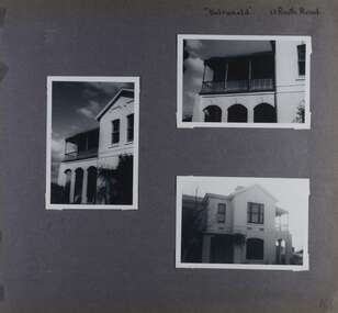 Glen Eira Historical Society
Album - Album page, Balranald, Poath Road, Circa 1972
... It is historically significant (Criterion A) as a substantial and now rare (Criterion B) surviving late Victorian villa residence east of Booran Road within the Municipality and demonstrating the attraction of Melbourne's rural fringe as a residential location rendered accessible by the opening of the railway between South Yarra and Oakleigh in 1879. It is aesthetically significant (Criterion E) as one of the Municipality's finest late Victorian polychrome brick villas, comparing with ''Fresch'' and ''Monkleigh'' both erected in 1899 at nos. 11 and 12 Gladstone Parade, Elsternwick respectively, ''Hartington'' (1888) at 15 Gladstone Parade and ''Hengar'' (1889) at no. 356 Glen Eira Road, Caulfield South. ...This photograph is part of the Caulfield Historical Album 1972. This album was created in approximately 1972 as part of a project by the Caulfield Historical Society to assist in identifying buildings worthy of preservation. The album is related to a Survey the Caulfield Historical Society developed in collaboration with the National Trust of Australia (Victoria) and Caulfield City Council to identify historic buildings within the City of Caulfield that warranted the protection of a National Trust Classification. Principal photographer thought to be Trevor Hart, member of Caulfield Historical Society. Most photographs were taken between 1966-1972 with a small number of photographs being older and from unknown sources. All photographs are black and white except where stated, with 386 photographs over 198 pages. Originally named Crofthead or The Croft Head, later changed to Balranald according to Melbourne Mansions database.From Victorian Heritage Database citation for HO136 13 Poath Street MURRUMBEENA https://vhd.heritagecouncil.vic.gov.au/places/35389 as at 30/10/2020 "Croft Head" is situated at no. 13 Poath Road, Murrumbeena, and was built in 1887 for the accountant Edward Tweddell. It is historically and aesthetically significant. It is historically significant (Criterion A) as a substantial and now rare (Criterion B) surviving late Victorian villa residence east of Booran Road within the Municipality and demonstrating the attraction of Melbourne's rural fringe as a residential location rendered accessible by the opening of the railway between South Yarra and Oakleigh in 1879. It is aesthetically significant (Criterion E) as one of the Municipality's finest late Victorian polychrome brick villas, comparing with ''Fresch'' and ''Monkleigh'' both erected in 1899 at nos. 11 and 12 Gladstone Parade, Elsternwick respectively, ''Hartington'' (1888) at 15 Gladstone Parade and ''Hengar'' (1889) at no. 356 Glen Eira Road, Caulfield South. Elements of stylistic significance include the ornamentation of the brickwork in polychrome work with tiled panels, the effect of the banding being especially striking and representative of the period.Page 166 of Photograph Album with three photographs of Balranald on Poath Road.Handwritten: "Balranald" 13 Poath Road [top right] / 166 [bottom right]trevor hart, decorative brackets, chimneys, verandah, porch, poath road, arches, cast iron columns, return verandah, croft head, balranald, victorian villa, restoration, 1880's, edward tweddell, murrumbeena, hughesdale, cast iron frieze, victorian style, cast iron work, rendered brick, house names, polychrome brick, poath street, crofthead, the croft head -
Glen Eira Historical Society
Book - Carnegie Primary School No. 2897
... Oakleigh Road... Frogmore Road... Koornang Park... Hunt Club Kennels... Raeke Miss... Morgan Miss... Pitt Winnie... Jiggins Mr.... Smith Mr.... Blundy Violet... Ryall Ray... Mimosa Road... Wolseley Mr.... Wolseley family... Wolseley Ted... Brunstein Madge... Murrumbeena Cricket Club... Sinclair Alan... Sincliar Tinny... Thomas Ted... Walker Alec... Bone Bob... Footballers... Middleton Colin... Farquahson Mrs.... Eddy family... Eddy Rose... Wolseley Jack... Buswell Stan... Buswell Doug... Buswell. Stan jnr.... Irving Nell... Brims Ethel... Bailey Bruce... Eason sisters... Hands Hilda... Windlow Isabel... Madden Road... Glenhuntly Road... Griffiths Rita... Jackson Jean... Scott Mr.... Ward ‘Cap’... Caulfield Grammar School... Kokaribb Road... Carnegie Traders... Cricket Teams... Carnegie South...Oakleigh Road Frogmore Road Koornang Park Hunt Club Kennels Raeke Miss Morgan Miss Pitt Winnie Jiggins Mr. Smith Mr. Blundy Violet Ryall Ray Mimosa Road Wolseley Mr. Wolseley family Wolseley Ted Brunstein Madge Murrumbeena Cricket Club Sinclair Alan Sincliar Tinny Thomas Ted Walker Alec Bone Bob Footballers Middleton Colin Farquahson Mrs. Eddy family Eddy Rose Wolseley Jack Buswell Stan Buswell Doug Buswell. Stan jnr. Irving Nell Brims Ethel Bailey Bruce Eason sisters Hands Hilda Windlow Isabel Madden Road Glenhuntly Road Griffiths Rita Jackson Jean Scott Mr. Ward ‘Cap’ Caulfield Grammar School Kokaribb Road Carnegie Traders Cricket Teams Carnegie South ...Carnegie Primary School centenary book (96 pages x 2 copies) ‘The First Hundred Years NO2897. Carnegie Primary School 1888-1988’ compiled and edited by Isabel Couper and Deidre Lynch. A detailed history of the school’s beginnings. Many informative memories and recollections from school’s first students and teachers; includes social history of area and people, football teams, debutante sets and school. Also a reprinted newspaper article from school’s Golden Anniversary and photo of school band; and a couple of social history photographs.anderson james, murrumbeena, glen huntly railway station, carnegie state school, wesleyan hall, neerim road, railway stations, carnegie primary school, rosstown, toolambool road, lynch deidre, mcvey claire, ross william murray, findlay francis, couper isabel, brown wesley, rosstown state school, brisbane w, carnegie uniting church, liddelow m.h., evans thomas, selboskar phyl, centenaries, margaret street, caulfield, brewster mr., taylor mr., draper mrs., mcfarlane mr., rule thomas, teachers, campbell ada, ‘ava’, campbell aubrey, campbell vera, matthews ben, hewitts road, matthews funeral service, funeral parlours, leo amy, leo alfie, rudge family, rudge mr., transport, phillips store, general store, phillips corner, emily street, hamlya family, pitt family, sheppard family, pemberton mr., pemberton mrs., dunlop misses, preschools, whitlam family, whitlam gordon, woods family, woods lorna, swaggie, swagman, liddelow amy, anderson mr., anderson archie, dunlop bill, phillips linda, hansen alice, lodge laura, fox arthur , hamlyn eric, hansen dagmar, cooper lina , woods lorna, waite family, cove family, johansen family, koornang road, market gardens, sheppard ernie, wood a.m., ‘nisava’, wood family, wood bill, evans rachel, evans thomas, wood millicent, whitfield mr., griffiths mr., wood malcolm, wood forest, wood joe, roxburgh miss, grange road, clifton street, lord street, wood frederick geo, egan miss dressmakers, whitlam fred, whitlam christine, whitlam george, whitlam gough, whitlam freda, whitfield mr., patterson road, graceburn avenue, griffiths r.h., koornang road, scales mr., reid athol, lording dr., mernda ave, farmstead, lord reserve, leman’s swamp, koornang park, cobby harry, larkin aircraft company, dawson howard, rosedale avenue, spencer reg, turner ruth, turner jack, turner noreen, turner marie, morton alan, morton barney, gardiner martin, frogmore estate, oakleigh road, frogmore road, koornang park, hunt club kennels, raeke miss, morgan miss, pitt winnie, jiggins mr., smith mr., blundy violet, ryall ray, mimosa road, wolseley mr., wolseley family, wolseley ted, brunstein madge, murrumbeena cricket club, sinclair alan, sincliar tinny, thomas ted, walker alec, bone bob, footballers, middleton colin, farquahson mrs., eddy family, eddy rose, wolseley jack, buswell stan, buswell doug, buswell. stan jnr., irving nell, brims ethel, bailey bruce, eason sisters, hands hilda, windlow isabel, madden road, glenhuntly road, griffiths rita, jackson jean, scott mr., ward ‘cap’, caulfield grammar school, kokaribb road, carnegie traders, cricket teams, carnegie south, ward marjory, ryan mr., phillips tony, phillips bessie, buckley street, phillips harriet, phillips marion, phillips ernest, phillips hilda, phillips david, phillips florence, phillips linda, lihou miss, jersey parade, meake family, skewe family, mansfield family, fraser jean, collister alma, sturges millie, retallick girls, lillywhite family, mason nellie, johns nancy, bowsfield family, jenner family, chisholm emma, chisholm doris, chisholm ivy, chisholm netta, chisholm beryl, chisholm eileen, wadsworth ethel, luke mr., plummer t.w., raecke miss, sargent ron, sarkie family, reid family, meake violet, collett reg, mcneil miss, scales mr., carmody thomas william, steele miss, young mac, young margaret, cooper cyril, cooper bill, whiteside d., broadbent neil, broadbent mr., carnegie theatre, theatres, morton family, clarke family, quickand neals grocery store, grocers, billy guyatt’s, shops, spencer the removalist, removalists, collister harold, collister bill, caulfield band, bands, carthews the drapers, drapers, mccarrons alec blacksmiths, skewes keith, oliver frank, pitt ‘squeaker’, knevitt ‘skeeter’ harry, jockeys, britter jack, stanistreet family, gear rita, culleen billy, tailors, sherwoods butchers, butchers, jersey parade, riley didlo, verne harry, cooper horace, cooper linda, cooper martin, cooper claude, cooper reginald, cooper stanley, cooper gladys, cooper muriel, cooper percival, cooper cyril, beaumont w.a., whittfield joe, beaumont eileen, major mary anne sister, major myrtle, major bessie, major alma, stagholl walter, stagholl margaret, stagholl eric, robertson bessie, robertson fred, robertson norman, robertson donald, robertson alma, robertson alan, baird neil, baird john, baird rosemary, dunn helen, baird ian, baird heather, baird dianne, petrie stuart, petrie richard, bailey ron, gaunt mabel, reading harold, reading marge, irwin joyce, dickson margaret, dickson jennifer, dickson peter, wood malcolm, wood millicent, wood forest, wood joe, sinclair ‘trinny’, roberts ‘fly’, footballers, malcolm mr., henderson reg, henderson alice, brew l., rule mr., philbrick mr., wood mr., trembath mr., keogh mr., plummer tom, lane a., fox ernest, souters, market gardeners, fox belle, fox bella, fox vern, couper margaret, couper sandra, couper peter, couper narelle, couper clare, couper jarrod, scott mr., doughty will, doughty tom, lloyd miss, islingworth master, adams joyce, hogan mr., markus jean, cosgrove joan, cosgrove mrs., cosgrove mr., marshall jim, kellow fred, fretwell elizabeth, fretwell betty, shepparson ave, singers, edmonson miss, butters shirley, harwood vera, bracher lloyd, dewhurst irene, dewhurst jack, boyle mr., gow jack, welch len, stanistreet harry, stanistreet jack, stanistreet kathleen, stanistreet frank, stanistreet kingsley, ‘ray sullivan’s harmony boys’, carnegie memorial hall, st. anthony’s hall, welch len, gibbons norm, ashley sylvia, crosswell edna, marks peggy, worth phyllis, cleal jean, tabner edith, jenkins elva, mcintosh gladys, worth reg, waters cyril, downard rex, wild mavis, wild darby, hill roland, eason jean, tyers noel, tyers clive, witten hope, strickland doris, chisholm beryl, harwood family, battershill sid, battershill walter, dixon mavis, boyle mr., ford hilda, forsythe miss, edmonsen miss, ryan mr., grimsley mr., allaway mrs., grant mrs., bone bob, bone bruce, w. bone & son nursery men, bone norman, bone jack, bone william, railway road, green kevin, paris marjorie, mimosa road, green joan, allaway winnie, elliot miss, mcburney mr., purdy mrs., allaway suzanne, barron shirley, hogan mr., rutherford mrs., curtin mr., mckee’s, stores, whelan’s, coles, koornang road, gardiner marty, grange road dairy, dairies, mcwhinney’s tuck shop, shops, williams dorothy, kennedy irene regina, rigby miss, grimsley steve, grimsley muriel, grimsley jack, grimsley margaret, grimsley aimee, grimsley bill, blinkinsop steve, blinkinsop jeannie, mathers max, howie rex, major mr., flatmans paddock, crossover, reid eric, reid athol, lowe margaret, lowe dorothy, lowe ian, poliomyelitis epidemic diseases, forsythe miss, cuddihy miss, dougall keith, grace miss, hattam’s, stores, driver wally, perry max, perry don, perry jack, meagher j., ‘hostile’, racehorses, edney jack, carthews the drapers, fretwell elizabeth, kellow fred, muddyman bill, graceburn ave, caulfield junior citizens band, bands, luke mr., luke percy, luke maise, luke nessie, luke geoff, luke ross, luke jan, luke lynette, bolton douglas, anderson mrs., mcburney mr., hogan mr., scott mr., tyers s., ross j., ryan j., irvine j., muirhead mrs., muirhead j., mcnab m., buller l., emmanuel p., buller m., paton v., moor j., condron a., bibby d., matthews n., holman l., cotterell m., whelan j., jennion g., walker b., taylor e., green a., turner r., matthews e., smith joan, gardiner marty, dairies, hanson family, cove family, gallop family, barrett family, barrett w.a., bolch family, bolch b., burke w., burke bill, burke s., mobbs h., young g., young c., burke m., ward c., hopwood g., gordon mr., milk bars, cooper cr., phillips t., swindell mr., grogan mr., wadsworth mrs., bourke mrs., lewis mrs., worsley mrs., quickenstead mrs., brown wesley, musicians, purdy h., curtain les, jenner’s dairy, riley’s wood yard, occupations, jenner vic, jenner les, grant noel, parker george, connolly keith, purdy mr., glen huntly picture theatre, picture theatres, irvine jack, law christie, hatter bob, joppick les, driver geoff, curtin mrs., frederick street, ormond, waters ron, carnegie junior citizens band, carnegie salvation army band – bands, whelan evan, irwin ray, balgleish jack, cowen laurie, smyth wally, lambeth margaret, kind lorraine, bondini joy, tredennick miss, linton miss, heath graham, shiell bill, shiell myrtle, archard bess, bull joan, craig ida, collins dorrie, collins doreen, diggans jess, cornthwaite h., cripps e., dougall n., dixon joyce, francis d., evans mrs., glass peg, greene jess, grace merle, hocking freda, jillings mrs., price mrs., day kitty, kerr may, mason marge, kind sylvia, muirhead d, mcconchie netta, needham nancy, nickless w, o’connor linda, pilven mrs., ryall h., strother ivy, singleton mrs., kelly phyl, waters von, usher mrs., trotter maude, watson mrs., williams mabel, withers olive, aarsmann norma, shiell norma, close peter, ‘wild cherry’ cake shop, rudi miss, anderson miss, eddy mr., hunter jean, nelson vera, fisher john, hunter ron, read jean, smith brian, newsreaders, nelson miss, singleton billy, quon miss, mchutchison george, valma smith, millar royal r., donoghue nora, lester mr., roberts tom, andreisen colin, miles alec, hine mr., baker mr., clements george, bracher lloyd, dimick miss, muir judy, dunn margaret, sant richard, myring miss, ryan mr., armstrong margaret, share wally, howie rex, barclay bob, rockman udo, hoult david, eisfelder kevin, jacques mr., smith mr., magee mr., stehle belinda, wallace mr., james mrs., main mr., wood miss, verso mr., mcpherson mrs., felotico miss, stehle john, howards mrs., collard mrs., webster vivian, stehle siggy, truong le sen, mcpherson barbara, mitchell eva, moutsos mark, chan benjamin, wilson del, jewell christopher, mitchell keith, grant marilyn, caskie alastair, dixon dennis, armstrong john, lucas edward, clark deanne, coutts natalie, flood zivanja, derham peter, momandwall shaper, couper jarrod, heslop joanne, breeze ginaya, caskie fiona, filippone nadya, mcmahon nina, hedges nigel, williams shae, grimm karen, mcgregor clare, vagenes john, gallagher glenn, mcalister rob, varga marilyn, hunter debbie, courtney cathy, booth carol, mcmahon mary, brown danielle, burska maciej, campbell jason, chryssis aris, d’arcy michael, delaney matthew, doukas vivian, dower samantha, fournarakis andrew, genoli amanda, grammatos jimmy, harrington melanie, karamoshos john, karim sadruddin, kennedy russel, lalani zahra, lightfoot kylie, looby mark, louange veronica, park sung mi, perera dennis, pozvek julie, scurry kate, sievers sarah, smith matthew, svarnas dennis, vassiliou denise, wright tracey, zouzounis spirros, adahall jojie, agar jude, anderson lynette, black renae, bobrowski ursula, caskie catherine, devon hayley, diakoumis maria, duljas kristie, evans lindsay, faucett ebony, filippone annette, fournarakis jimmy, francese sean, gibson jay, gordon michelle, guslitser dora, king jane, lianos villi, lorkin christopher, macleod cheryl, maggs amberley, mitchell keith, mucic renae, o’brien jessica, park matthew, pozvek richard, psarras nancy, rhodes suzanne, simons emma, smith christopher, spokes melanie, tia michael, timewell amanda, vavoudis peter, abbott kristi, allender daniel, bobrowski jacob, carey rebecca, carter daimein, catramados john, christou eugenia, couper jarrod, healey michael, kalaitzakis nick, kennedy rebecca, macleod suzanne, mavridis angelo, morosini amanda, mowforth dustin, okolicsanyi george, park sung chul, pemberton michael, reisman elizabeth, richards kylie, savrone leah, tia charlie, tran paul, wiseman derek, wright dean, wyatt marilyn, andre ryan, breeze ginaya, brown james, campbell chad, charles benjamin, devon john, diakmoumis stacey, diamantis chris, duljas michael, grammatos harry, hill bradd, karim salim, lindsay amanda, lynch jennifer, marrello sol, momandwall shaker, moutsos ireni, oram scott, o’sughrue kristy, panevin david, park catherine, pozvek louise, stratton alisa, timewell rebecca, tsigos stam, yeow sook ling, anderson peter, batson tracey, black craig, brain jason, breeze benjamin, brown kylie, carrington harata, caskie fiona, catramados hercule, chan daphne, christou chris, clarke simone, diamantis anthony, faucett sara, flood natalia, holmes gavin, kotrotsos tony, kuk robin, mitchell david, okolicsanyi steve, pemberton samuel, soos melinda, stephenson gabrielle, tran pauline, vassiliou evan, agar natalia, bennett tracey, buhmann wayne, couper clare, faucett sean, filippone nadya, filippone marie, gallagher glenn, gelman roman, grant shawn, hill tania, jewel chris, kaliappa danny, kiss robert, liacopoulos aris, louey david, macleod mike, malamas voula, oram michelle, scurry ivan, wardley amanda, zouzounis sam, anderson robert, antoniou nick, carey tamara, derham peter, diep dianne, filippone danielle, flood zivanja, frangos katina, handley scott, harrison robin, heath cheryl, hedges megan, hedges nigel, hudson raelene, jacovou daniel, katrotsos george, kuk maggie, leung tracy, lightfoot wendy, mcmahon nina, taylor stephen, vassiliou litsa, liddelow e., anderson james h., boardman thomas h., rule thomas, whitfield j.p., griffiths r.h., scales e., boyle j.b., ryan owen w., eddy h.m., millar royal r., lester russel a., donoghue r., bracher a. lloyd (acting principle), o’brien john d., moller henry r., monahan t.v., barclay robert l., somerville albert v., magee frank c. (acting principle), wallis keith, laing allan i., verso ron (acting principle), wood moira (acting principle), tonkin ernest, share wallace (acting principle), howie rex, harding malcolm (acting principle), crowe brian, schmidt david (acting principle), lynch deidre (acting principle), o’keeffe leo, brierley bob, brierley marjorie, couper isabel, couper peter, lindsay janine, lynch deidre, selboskar phyl, stehle siggy, webster jennifer -
Glen Eira Historical Society
Ephemera - Caulfield Cricket Club
... South Caulfield Cricket Club... North Caulfield Glenhuntly Cricket Club... Malvern Cricket Club... Sheehan Tony... Damiano Ricky... Oakleigh...Caulfield Cricket Club Ormond Cricket Club Elsternwick Cricket Club South Caulfield Cricket Club North Caulfield Glenhuntly Cricket Club Malvern Cricket Club Sheehan Tony Damiano Ricky Oakleigh Cricket Club Morrison Brian Little Harold Christiansen Cam Harwood Shane Richardson Shaun Murrumbeena Cricket Club Carnegie Cricket Club MCG Melbourne Cricket Grounds Nurse Harry Reilly Geoff Shipley Colin Jacobs Bill Lahiff Tommy Haviland James Pritchard Heath Cruickshank Daron Hansen Michael Lawrence Matt Warren Adam Baldry Leigh VTCA Twenty 20 Club Cosgrove Adam Cricket Cricket Clubs Cricketers Sporting Clubs Sports Ephemera Caulfield Cricket Club ...This file contains two items. A menu and programme for Caulfield Cricket Club. Includes handwritten list of names of office-bearers and printed list of sponsors. Thirty-four newspaper clippings on Caulfield Cricket Club. “Haviland, Pritchard give Caulfield Boost”, cutting from Caulfield Port Phillip Leader, 21/12/2010 on recent match. “Daron Cruickshank Shows His Class” cutting from Caulfield Port Phillip Leader 11/01/2011 on Daron Cruickshank from Trinidad-Tobago who whit 111 not out in recent match for Caulfield against Ormond. “Century Lifts Monds, Another Ton For Hansen” cutting from Caulfield Port Phillip Leader on 01/02/2011 on recent centuries by Michael Hansen of Ormond in matches. “Fields Take Minor Premiership” cutting from Caulfield Port Phillip Leader 08/03/2011 on forthcoming match of Elsternwick against Coburg. “Richo’s Century Puts Caulfield in Driver’s Seat” cutting from Caulfield Port Phillip Leader 15/03/2011 on Shaun Richardson’s 160 for Caulfield against Brunswick in a recent match. “Caulfield Up for Challenge” by Brad Beitzel cutting from Caulfield Port Phillip Leader 22/03/2011 on forthcoming match against Coburg. “Fielders Work For It. Sliver of Hope Going Into Day Two” by Paul Amy, cutting from Caulfield Port Phillip Leader 29/03/2011 on recent match of Caulfield against Malvern. Photograph, cutting from Caulfield Port Phillip Leader 05/04/2011 of batsman Matt Lawrence who had announced his retirement, pictured with unnamed wicket-keeper. “‘Grub’ will be missed” cutting from Caulfield Port Phillip Leader 12/04/2011. Obituary of Tony Sheehan who represented Caulfield in 170 matches. “Caulfield Goes in to Bat Early” cutting from Caulfield Port Phillip Leader 03/05/2011 on recent recruits Adam Warren and Rob Bartlett for forthcoming season. “South Caulfield on Top” cutting from Caulfield Port Phillip Leader 01/11/2011 on prospects of South Caulfield Club and recent matches. “Monds Break Duck” cutting from Caulfield Port Phillip Leader 31/01/2012 on recent win by Ormond Club. “Help To Put Cancer Fund in the Pink” article from the Caulfield Port Phillip Leader dated 07/02/2012 concerning the Caulfield South Cricket Club’s participation in Pink Stumps Day in order to raise funds for cancer research. “Premier Cricket” by Brad Beitzel, cutting from Caulfield Port Phillip Leader 14/02/2012 on recent watches of local clubs. “Damiano’s Three Tons A record” by Brad Beitzel, cutting from Caulfield Port Phillip Leader 28/02/2012 on batting record of Ricky Damiano. “Caulfield Digs In. Baldry Leads Lower Order Fight Against Malvern” by Paul Amy, cutting from Caulfield Port Phillip Leader 13/03/2012 on undefeated season of Caulfield club and future match. “Fields Bound For Glory. Rugged Day for Elsty” by Brad Beitzel cutting from Caulfield Port Phillip Leader 20/03/2012 on success of Caulfield Club. “Fielders Perfect Finish. Golden Summer Capped by Premiership” by Brad Beitzel cutting from Caulfield port Phillip Leader 27/03/2012 on undefeated season of Caulfield Club. “Caulfield Leaders Pay Hospital Visit to Club Stalwart. That Was For ‘Morro’” by Paul Amy cutting from Caulfield Port Phillip Leader 02/03/2012 on visit to ill Brian Morrison. “Caulfield Hearts Heavy After Death of Club Legend ‘Morro’” by Paul Amy cutting from Caulfield Port Phillip Leader 10/04/2012 on death of Brian Morrison. “Big Send Off For Legend ‘Morro’” cutting from Caulfield Port Phillip Leader 17/04/2012 on funeral of Brian Morrison. “Cricket Season to Commence” clipping from unnamed journal or magazine, hand dated 10/12 on new cricket season. “Christiansen Cracks Ton in Elsternwick Victory”, cutting from Glen Eira Port Phillip Leader 30/10/2012 on century by Cam Christiansen in match against Malvern. “Harwood Hits Hard to Set test For Caulfield” by Paul Amy cutting from Glen Eira Port Phillip Leader 13/11/2012 on performance of Shane Harwood in match against Melton. “ ‘Richo’ To The Rescue” by Paul Amy cutting from Glen Eira Port Phillip Leader 11/12/2012 on performance of Shaun Richardson in match against Williamstown. “Victorian Turf Cricket Association South Poised for Outright Win Against Bernies” cutting from Glen Eira Port Phillip Leader 29/01/2013 on match between South Caulfield and St. Bernards. “Tough Chase Awaits Caulfield” cutting from Glen Eira Port Phillip Leader 22/01/2013 on prospects of Caulfield Club. “Stateswide Twenty 20 Cup. South Caulfield Gets The Chance To Play At the MCG” photocopy of article in Glen Eira Port Phillip Leader 12/02/2013 that the team is to play in the MCG in finish of Twenty 20 Competition. “Nurse to the rescue for Wiaks” by Paul Amy cutting from Glen Eira Port Phillip Leader 19/02/2013 on century by Harry Nurse in match against Yarraville. “VTCA South Caulfield Crowned Twenty 20 Champion” cutting from Glen Eira Port Phillip Leader 12/03/2013 on win by South Caulfield in state wide Twenty 20 Cup. “Sub-District Cricket Finals. Caulfield Up Agianst Melton and Weather” cutting from Glen Eira Port Phillip Leader 19/03/2013 on semi-final match between Caulfield and Elsternwick. “Cricket Championship Team” photograph cutting from Glen Eira Port Phillip Leader 09/04/2013 of Championship Caulfield Club with thirteen players named in caption. “Cricket High Hopes for Scholarship Winner” cutting from Glen Eira Port Phillip Leader 16/04/2013 on cricket scholarship for Adam Cosgrove, aged twelve.caulfield cricket club, ormond cricket club, elsternwick cricket club, south caulfield cricket club, north caulfield glenhuntly cricket club, malvern cricket club, sheehan tony, damiano ricky, oakleigh cricket club, morrison brian, little harold, christiansen cam, harwood shane, richardson shaun, murrumbeena cricket club, carnegie cricket club, mcg, melbourne cricket grounds, nurse harry, reilly geoff, shipley colin, jacobs bill, lahiff tommy, haviland james, pritchard heath, cruickshank daron, hansen michael, lawrence matt, warren adam, baldry leigh, vtca, twenty 20 club, cosgrove adam, cricket, cricket clubs, cricketers, sporting clubs, sports -
Glen Eira Historical Society
Article - St Peter's Catholic Church, Bentleigh East
... South... Bignell Road... Kennedy Market Garden... Oakleigh...O’ Connell John FR Glass Hugh MR O’ Farrell Peter Brady Peter Kennedy James Boland Michael McCormick Francis Orrong Road Little Brighton Oakleigh Port Phillip Bay East Boundary Road North Road Ormond Old Dandenong Road Mordialloc Creek Moorabbin Springvale No Good Damper Road Kingstown Keysborough Bignell Road South Road Heatherton Big Brighton Gardenvale Elsternwick Brady Road Jasper Road Chesterville Road Cochrane Road McGuinness Road H.A.C.B.S. ...Included In The File is A Newspaper Clipping From The Age Newspaper, Dated Sat 09/11/1974 On The Opening Written By Stuart Sayers. The Article Mentions A Brief History Of The Church & School Beginnings & The Opening Ceremony. There Are Two Copies Of The Living Harvest (One Without The Cover), The Book Gives A Detailed History Of St Peter's Catholic Church, Bentleigh East Written By W.T. Dobson And Published in 1974. From The First White Settlers, The Irish Exodus, And The Irish Catholic families, The School House And The History Of The Parish & Clergy Up To 1974.st peter's catholic church, niall patrick rev, emerald hill, bentleigh east, dobson w. t., yarra, moorabbin, heriot m. b., elsternwick, north road, quinn fred, bentleigh, centre road, kennedy james joseph, melbourne south, bignell road, kennedy market garden, oakleigh, st peter's parish, st james parish, the living harvest, catholic church, hibernian society, bavarian brass band, st peter's primary school, st james regional college, brighton catholic school, brighton – st kilda mission, niall patrick william fr, dendy henry, guiney john mr, king richard, king john, keys george, o’ shanassy john, keys robert, were jonathan b., o’ connell john fr, glass hugh mr, o’ farrell peter, brady peter, kennedy james, boland michael, mccormick francis, orrong road, little brighton, oakleigh, port phillip bay, east boundary road, north road, ormond, old dandenong road, mordialloc creek, moorabbin, springvale, no good damper road, kingstown, keysborough, bignell road, south road, heatherton, big brighton, gardenvale, elsternwick, brady road, jasper road, chesterville road, cochrane road, mcguinness road, h.a.c.b.s., school house, st patrick's church, brighton parish, denominational school, little brighton school, moorabbin catholic school, temporary chapel, st james regional college, sister of mercy, lanigans ball, east brighton public hall company ltd, east bentleigh hall, messrs. robert dunn & son, bavarian brass band, st joan of arc parish, east bentleigh parish, the sisters of our lady of sacred heart, the anchor club, mccormick cornelius, cochrane james, cochrane david, mcguinness margaret, cormick john, cahill james, quinn frederick, prendegast john patrick, naughton dennis, leary william, charlston john, carey matthew fr, gibbons patrick, kennedy joseph james, o’ sullivan tim fr, mckenna fred fr, casey william fr, browne joseph fr, crawford mal fr, hanrahan mr, gillon rose miss, sampson kate mrs, horan miss, coakley daniel fr, dillon kevin fr, whitehouse ray fr, mannix daniel dr, dobson william mr, gahan patrick, hallinan thomas, delaney john, fitzgerald patrick, st peter's catholic church