Showing 159 items matching " southern ocean"
-
 Moorabbin Air Museum
Book - RESCUE IN THE SOUTHERN OCEAN, Penguin Books Australia Ltd, 1997
... RESCUE IN THE SOUTHERN OCEAN...RESCUE IN THE SOUTHERN OCEAN...Moorabbin Air Museum Moorabbin Airport 12 First Street Moorabbin melbourne RESCUE IN THE SOUTHERN OCEAN Book RESCUE IN THE SOUTHERN OCEAN Penguin Books Australia Ltd ... -
Moorabbin Air Museum
Document (Item) - Engineers Australia SOS Technology behind dramatic rescue operations in Southern Ocean
... Engineers Australia SOS Technology behind dramatic rescue operations in Southern Ocean...Moorabbin Air Museum Moorabbin Airport 12 First Street Moorabbin melbourne Document Engineers Australia SOS Technology behind dramatic rescue operations in Southern Ocean ... -
Phillip Island and District Historical Society Inc.
Book, BLAIR, David, Cyclopedia of Australasia, or, dictionary of facts, events, dates, persons, and places connected with the discovery, exploration, and progress of the British dominions in the south, from the earliest dawn of discovery in the southern ocean to the year 1881, 1881
... Cyclopedia of Australasia, or, dictionary of facts, events, dates, persons, and places connected with the discovery, exploration, and progress of the British dominions in the south, from the earliest dawn of discovery in the southern ocean to the year 1881...Phillip Island and District Historical Society Inc. phillip-island-and-the-bass-coast Cyclopedia of Australasia, or, dictionary of facts, events, dates, persons, and places connected with the discovery, exploration, and progress of the British dominions in the south, from the earliest dawn of discovery in the southern ocean to the year 1881 Book BLAIR, David Fergusson and Moore ... -
 Kew Historical Society Inc
Book, Libraries Board of South Australia, An historical journal of the transactions at Port Jackson and Norfolk Island with the discoveries which have been made in New South Wales and in the southern ocean since the publication of Phillip's voyage, compiled from the official papers, including the journals of Governors Phillip and King and of Lieut. Ball, and the voyages from the first sailing of the Sirius in 1787, to the return of that ship's company to England in 1792, 1968
... An historical journal of the transactions at Port Jackson and Norfolk Island with the discoveries which have been made in New South Wales and in the southern ocean since the publication of Phillip's voyage, compiled from the official papers, including the journals of Governors Phillip and King and of Lieut. ...An historical journal of the transactions at Port Jackson and Norfolk Island with the discoveries which have been made in New South Wales and in the southern ocean since the publication of Phillip's voyage, compiled from the official papers, including the journals of Governors Phillip and King and of Lieut. ...Facsimile of journals of the voyages from England to Port Jackson and Norfolk Island and return by Governors Phillip and King, and Lieut. Ball 1787-1792, including maps, charts, drawings and tables. Reproduced from a copy held in the State Library of South Australia originally published in 1793.583 p., <16> leaves of plates (2 folded) : ill., maps, 1 port. non-fictionFacsimile of journals of the voyages from England to Port Jackson and Norfolk Island and return by Governors Phillip and King, and Lieut. Ball 1787-1792, including maps, charts, drawings and tables. Reproduced from a copy held in the State Library of South Australia originally published in 1793.norfolk isalnd - history, port jackson, hunter, john (1737-1821) -
Glenelg Shire Council Cultural Collection
Souvenir - Souvenir Pennant - Portland, Victoria, n.d
... ... southern ocean...Image of cargo ship in port, in orange and white, orange and white printing 'PORTLAND AUSTRALIA VICTORIA'S DEEP SEA PORT ON THE SOUTHERN OCEAN'...Glenelg Shire Council Cultural Collection History House Cliff Street Portland great-ocean-road souvenir of Portland Portland Harbour deep sea port southern ocean Souvenir felt pennant. Black felt, plain on back, yellow felt hanging tabs. ...Souvenir felt pennant. Black felt, plain on back, yellow felt hanging tabs. Image of cargo ship in port, in orange and white, orange and white printing 'PORTLAND AUSTRALIA VICTORIA'S DEEP SEA PORT ON THE SOUTHERN OCEAN'souvenir of portland, portland harbour, deep sea port, southern ocean -
 Port Fairy Historical Society Museum and Archives
Photograph
... Southern Ocean, off Port Fairy, Victoria, Australia ...Victoria (580 tons) was the first warship to be built in England for a British colony. Designed by the British naval architect Oliver Lang she was launched in London on 30 June 1855 by Lady Constance Talbot. Arrived in Australia 1856. Out of service 1882 and broken up in 1895 Visited Port Fairy 1859, 1862 and 1873 (twice) Black & white photographvictoria, war ship, ship, navy, lady constance talbot -
 Port Fairy Historical Society Museum and Archives
Photograph
... Southern Ocean, off Port Fairy, Victoria ...Victoria (580 tons) was the first warship to be built in England for a British colony. Designed by the British naval architect Oliver Lang she was launched in London on 30 June 1855 by Lady Constance Talbot. Arrived in Australia 1856. Out of service 1882 and broken up in 1895 Visited Port Fairy 1859, 1862 and 1873 (twice) First warship to be built in England for a British colony. Black & white photographwarship, hmvs victoria -
 Port Fairy Historical Society Museum and Archives
Photograph, 1924
... Southern Ocean, nr Port Fairy, Victoria, Australia ...SS Casino was a regular commuter between the ports of Apollo Bay and Port Fairy Black and white photograph of Coastal trader s.s.Casino at seaship, boat, sea, river, casino -
 Port Fairy Historical Society Museum and Archives
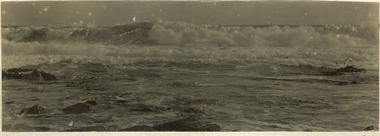
Photograph
... Black and white photographs of the Southern Ocean crashing on the reef these are glued together back to back...Port Fairy Historical Society Museum and Archives 30 Gipps Street Port Fairy great-ocean-road beach ocean south sea rocks waves Black and white photographs of the Southern Ocean crashing on the reef these are glued together back to back Photograph Photograph ...Black and white photographs of the Southern Ocean crashing on the reef these are glued together back to backbeach, ocean, south, sea, rocks, waves -
Lakes Entrance Historical Society
Map - Lakes Entrance Gippsland Sheet No.2, W Dawson District Surveyor. Henry Davidson, 9/4/1866
... Shows waterways, The Narrows, Reeves River, North Arm, Back Lake, Southern Ocean, Mt. Barkly, Jemmys Point, Bullock Island...Waterways Islands Topography Shows waterways, The Narrows, Reeves River, North Arm, Back Lake, Southern Ocean, Mt. Barkly, Jemmys Point, Bullock Island Map Lakes Entrance Gippsland Sheet No.2 W Dawson District Surveyor. ...Shows waterways, The Narrows, Reeves River, North Arm, Back Lake, Southern Ocean, Mt. Barkly, Jemmys Point, Bullock Islandwaterways, islands, topography -
 Lakes Entrance Historical Society
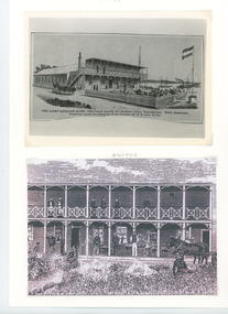
Photograph - The Lakes Entrance Hotel/Thomas Laughton, 1889
... The Lakes Entrance Hotel (immediately opposite the Southern Ocean Cunninghame) Edwin Stephenson Proprietor(under the patronage of the Governor Sir H B Lock K C B). ...Lakes Entrance Historical Society 4 Marine Parade Lakes Entrance gippsland Lakes Entrance Hotel erected 1878 by Thomas Laughton Also second sketch of front of the hotel with 6 people on upper balcony Buildings Hotels genealogy The Lakes Entrance Hotel (immediately opposite the Southern Ocean Cunninghame) Edwin Stephenson Proprietor(under the patronage of the Governor Sir H B Lock K C B). ...Lakes Entrance Hotel erected 1878 by Thomas Laughton Also second sketch of front of the hotel with 6 people on upper balcony Black and white photograph of a drawing of the Lakes Entrance Hotel. It shows a stylised view of a large weatherboard building with verandah across the main entrance with a viewing platform above. Horse drawn vehicle beside hotel, signal flagpole at front, a schooner and steamer in distant waterway. Lakes Entrance Victoria. Second and third sketch of of hotelThe Lakes Entrance Hotel (immediately opposite the Southern Ocean Cunninghame) Edwin Stephenson Proprietor(under the patronage of the Governor Sir H B Lock K C B). buildings, hotels, genealogy -
 Lakes Entrance Historical Society
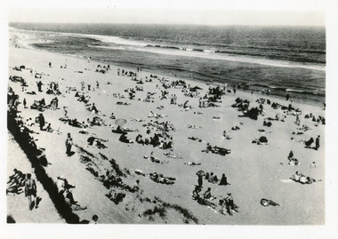
Postcard - Ocean Beach Lakes Entrance Victoria c1950
... It shows portion of a brush windbreak fence, large expanse of sandy beach, & Southern Ocean. Lakes Entrance Victoria...It shows portion of a brush windbreak fence, large expanse of sandy beach, & Southern Ocean. Lakes Entrance Victoria Postcard Ocean Beach Lakes Entrance Victoria c1950 ...2nd postcard the same image, 3rd postcard tinted, same imageBlack and white small format postcard of a crowd of people on the ocean beach. It shows portion of a brush windbreak fence, large expanse of sandy beach, & Southern Ocean. Lakes Entrance Victoriarecreation, beaches -
 Lakes Entrance Historical Society
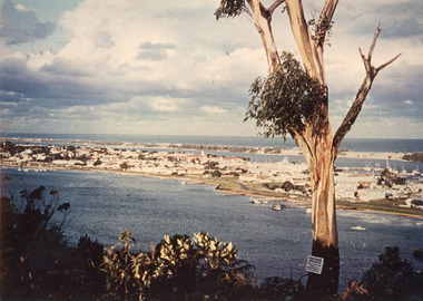
Photograph, North Arm and the Cunninghame Arm. Lakes Entrance Victoria, 1980
... In the background can be seen the sand hummocks and the Southern Ocean. Lakes Entrance Victoria...In the background can be seen the sand hummocks and the Southern Ocean. Lakes Entrance Victoria North Arm and the Cunninghame Arm. ...Also two different views of Lakes Entrance from KalimnaColour photograph showing the township situated on the land between the two stretches of water, the North Arm and the Cunninghame Arm. In the background can be seen the sand hummocks and the Southern Ocean. Lakes Entrance Victoria township, waterways -
 Lakes Entrance Historical Society
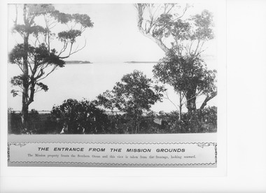
Photograph - Lake Tyers Victoria, Caire, Nicholas John, 1905c
... The mission property fronts the southern ocean and this is taken from the frontage looking seaward....Lakes Entrance Historical Society 4 Marine Parade Lakes Entrance gippsland The mission property fronts the southern ocean and this is taken from the frontage looking seaward. ...The mission property fronts the southern ocean and this is taken from the frontage looking seaward.Black and white photograph of a view from Aboriginal Mission looking south to Lake Tyers Entrance, to ocean. Mia Mia of sapling and blanket in foreground. Lake Tyers VictoriaThe Entrance from the Mission Groundswaterways, aboriginals -
 Bendigo Military Museum
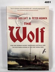
Book - BOOK, WW1 NAVAL HISTORY, GUILLIATT Richard & HOHNEN Peter, " THE WOLF', 2009
... "THE WOLF' How one German raider terrorised Australia and the Southern Oceans in the First World War....Bendigo Military Museum 37 - 39 Pall Mall Bendigo goldfields "THE WOLF' How one German raider terrorised Australia and the Southern Oceans in the First World War. Book WW1 Naval Operations Nil Soft cover book. ..."THE WOLF' How one German raider terrorised Australia and the Southern Oceans in the First World War.Soft cover book. Soft cover - cardboard, red and black print on front, spine and back. Cover - colour illustrated - front - top German symbol, bottom, ship at sea. Back - sepia photograph - sailor and girl. 366 pages - cut, plain, off white paper. Illustrated black and white photographs and maps.Nilbook, ww1, naval operations -
Lakes Entrance Historical Society
Plan - Diagram Plan of Survey at Mount Barkly Gipps Land Lakes
... Plan of waterways, The Narrows, North Arm, Reeves River to the Entrance, Snake Island, Lancet Island, Rigby Island Southern Ocean...Lakes Entrance Historical Society 4 Marine Parade Lakes Entrance gippsland Plan of waterways, The Narrows, North Arm, Reeves River to the Entrance, Snake Island, Lancet Island, Rigby Island Southern Ocean Waterways Islands Ocean Plan of survey at Mount Barkly Plan Diagram Plan of Survey at Mount Barkly Gipps Land Lakes ...Plan of waterways, The Narrows, North Arm, Reeves River to the Entrance, Snake Island, Lancet Island, Rigby Island Southern OceanPlan of survey at Mount Barklywaterways, islands, ocean -
 Lakes Entrance Historical Society
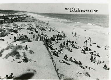
Postcard - Ocean Beach Lakes Entrance c1950's, c1950
... It shows a crowd of people on the sand dunes, remains of a brush fence, Southern Ocean and Red Bluff in distance. Taken from original tower, built for Royal Lifesaving Club. ...It shows a crowd of people on the sand dunes, remains of a brush fence, Southern Ocean and Red Bluff in distance. Taken from original tower, built for Royal Lifesaving Club. ...2 other copiesBlack and white small format postcard of bathers at the ocean beach. It shows a crowd of people on the sand dunes, remains of a brush fence, Southern Ocean and Red Bluff in distance. Taken from original tower, built for Royal Lifesaving Club. Lakes Entrance VictoriaBathers, Lakes Entrance topography, people, beaches, recreation -
Glenelg Shire Council Cultural Collection
Souvenir - Felt Pennant, Screencraft, n.d
... Large orange 'Portland Victoria's Deep-Sea Port on the Southern Ocean' and 'Australia', in white along length of pennant. ...Large orange 'Portland Victoria's Deep-Sea Port on the Southern Ocean' and 'Australia', in white along length of pennant. ...Dark blue felt pennant. Image of ship being loaded at wharf, orange and white. Large orange 'Portland Victoria's Deep-Sea Port on the Southern Ocean' and 'Australia', in white along length of pennant. Back plain. White fabric makers tag. Souvenir of Portland.Front: 'Screencraft' - white Back: White fabric tag 'Screencraft 49 Little Latrobe Street Melbourne FT 6510' Red print -
 Lakes Entrance Historical Society
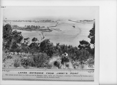
Photograph - Gippsland Lakes from Jemmy's Point, Caire, Nicholas John, 1905c
... This vantage ground shows a birds eye view the Entrance works, which give Gippsland a waterway to Melbourne by keeping open a connection with the Southern Ocean....This vantage ground shows a birds eye view the Entrance works, which give Gippsland a waterway to Melbourne by keeping open a connection with the Southern Ocean. Waterfront Boats and Boating Township Waterways Islands Black and white photograph of a panorama of the artificial entrance to the Gippsland Lakes. ...Lakes Entrance from Jimmy's Point. This vantage ground shows a birds eye view the Entrance works, which give Gippsland a waterway to Melbourne by keeping open a connection with the Southern Ocean.Black and white photograph of a panorama of the artificial entrance to the Gippsland Lakes. The New Works village on the lake shore of the hummocks, the rock groynes at Bullock Island and a steamer in the main shipping channel of the lake. Back view of a woman in hat and dark clothing seated amongst vegetation in foreground. Lakes Entrance Victoriawaterfront, boats and boating, township, waterways, islands -
 Flagstaff Hill Maritime Museum and Village
Photograph - Historical, Flagstaff Hill, John Lindsay, View of the Bay from the south boundary of the Ports and Harbours land, 1970s
... In the background is Lady Bay and the Breakwater and Middle Island, with the Southern Ocean the other side. The photograph's paper has the printer's watermark and a pencilled inscription on the back. ...In the background is Lady Bay and the Breakwater and Middle Island, with the Southern Ocean the other side. The photograph's paper has the printer's watermark and a pencilled inscription on the back. ...The photograph shows the view of the shore and Lady Bay with the Breakwater and Middle Island all visible. It was taken to show that the Flagstaff Hill area was unlikely to have any further development between it and the Bay, with the view of development of the Flagstaff Hill Maritime Museum and Village. This photograph, a print, is one of a set of five that show the site of Flagstaff Hill. The photographer was John Lindsay, Founding Director of Flagstaff Hill Maritime Museum and Village, with the words "Photo J Lindsay" on the back. It was taken in the early 1970s during the initial stages of the development of Flagstaff Hill as a Museum and Maritime Village. The photographs belonged to the donor's grandparents, who lived in the Warrnambool district of Allansford/Naringal. The photograph is a record of the site and surrounds of Flagstaff Hill Maritime Museum and Village before its development and opening in 1975. It shows the Surfside Holiday Park, Surf Lifesaving Club, and the Breakwater. The photograph is significant for recording the location and condition of the Lower Lighthouse on the Hill.Coloured photograph, glassy print, one of a set of five. Flagstaff Hill's Lower Lighthouse is in the foreground above the Surfside Holiday Park. To the right of centre is the Surf Lifesaving Club. In the background is Lady Bay and the Breakwater and Middle Island, with the Southern Ocean the other side. The photograph's paper has the printer's watermark and a pencilled inscription on the back. The early 1970s scene was photographed by John Lindsay, Warrnambool.Label on the back: "VIEW OF THE BAY FROM the southern boundary of the Ports and Harbours land. No development below this area is likely to obstruct the view, due to the steep grade down to the Southern boundary of Flagstaff Hill property." Handwritten in pencil: "Photo J Lindsay"flagstaff hill, flagstaff hill maritime museum and village, warrnambool, maritime museum, maritime village, great ocean road, shipwreck coast, 1970s, photograph, surfside holiday park, lady bay, flagstaff hill site, john lindsay, lower lighthouse, lower light, surf lifesaving club, breakwater, middle island, ports and harbours -
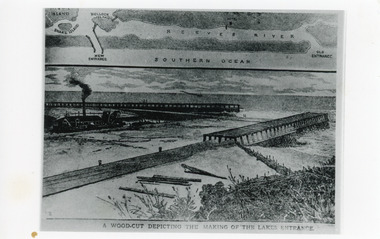 Lakes Entrance Historical Society
Photograph - Entrance Works, 1880c
... Map above showing position of the lakes, old and new entrances, southern ocean and sand dune vegetation. Lakes Entrance Victoria. ...Map above showing position of the lakes, old and new entrances, southern ocean and sand dune vegetation. Lakes Entrance Victoria. ...Photographic reproduction of woodcut drawing of the building of the entrance and map above of location.Black and white photograph of a woodcut showing dredge working between timber constructed piers on entrance from the lakes to the ocean Bass Strait. Piers unfinished, timber lying around, sand in the entrance. Map above showing position of the lakes, old and new entrances, southern ocean and sand dune vegetation. Lakes Entrance Victoria. Plus second sketch depicting early worksA woodcut depicting the making of the Lakes Entrance.public works, dredging, waterways -
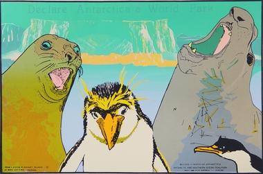 Merri-bek City Council
Print - Silkscreen, Wendy Black, Declare Antarctica a World Park, 1982
... Text in the lower corner describes Black’s collaboration with the Antarctic and Southern Ocean coalition for which this poster was likely made. ...Text in the lower corner describes Black’s collaboration with the Antarctic and Southern Ocean coalition for which this poster was likely made. ...Melbourne-based artist Wendy Black works across screenprinting, painting and drawing. The 1980s saw a rise in campaigns for Antarctica to be designated a World Park to ensure the ongoing protection of its natural resources and its continuation as a peace zone. Black’s screenprint, featuring seals and penguins set against an Arctic icecap, captures the looming threat to the precious flora and fauna of the continent. Text in the lower corner describes Black’s collaboration with the Antarctic and Southern Ocean coalition for which this poster was likely made. Donated by the artist -
 Flagstaff Hill Maritime Museum and Village
Photograph - Historical, Flagstaff Hill, Warrnambool Garrison Fortifications looking towards the Moyjil (Point Ritchie), 1970s
... The left shows the sore of Lady Bay with the cliffs of the Southern Ocean in the distance. The photograph's paper has the printer's watermark on the back. ...The left shows the sore of Lady Bay with the cliffs of the Southern Ocean in the distance. The photograph's paper has the printer's watermark on the back. ...The photograph shows the location of the concrete, horseshoe shaped gun emplacement erected for the cannons. It is part of the Historic Precinct on Flagstaff Hill. The area was accessed either through the space between the Lighthouses (through the cottage grounds) or a service entrance, past the iron huts used by the Lands Department. This photograph, a print, is one of a set of five that show the site of Flagstaff Hill. It is presumed to have been taken by John Lindsay, Founding Director of Flagstaff Hill Maritime Museum and Village. One of the photographs in the set has the pencil inscription "Photo J Lindsay". It was taken in the early 1970s during the initial stages of the development of Flagstaff Hill as a Museum and Maritime Village. The photographs belonged to the donor's grandparents, who lived in the Warrnambool district of Allansford/Naringal. The photograph is a record of the site and surrounds of Flagstaff Hill Maritime Museum and Village before its development and opening in 1975. It shows the east side of the Surfside Holiday Park in its earlier days. The photograph is significant for recording the location and condition of the original concrete cannon emplacement on the Hill.Coloured photograph, glassy print, one of a set of five. Photograph shows the original site of one of the gun emplacements for the cannons, cannons Historical, looking towards the Moyjil, ,Point Ritchie and overlooking Lady Bay, Warrnambool. The horseshoe shaped concrete gun emplacement is in the foreground on the grassed slopes overlooking the Bay. The site and ablution block of the Surfside Holiday Park is centre right. The left shows the sore of Lady Bay with the cliffs of the Southern Ocean in the distance. The photograph's paper has the printer's watermark on the back. The early 1970s scene is presumed to have been photographed by John Lindsay, Warrnambool.Label on the back: "FIRST GUN EMPLACEMENT LOOKING TOWARDS THE HOPKINS / This is the original site of one of the cannons overlooking the Bay. Access to this area could be between the light-houses (throught the cottage grounds), or a service entrance - past the iron huts used by Lands Department."flagstaff hill, flagstaff hill maritime museum and village, warrnambool, maritime museum, maritime village, great ocean road, shipwreck coast, 1970s, photograph, gun emplacement, surfside holiday park, lady bay, hopkins river, flagstaff hill site, john lindsay, concrete gun emplacement, cannon emplacement, original emplacement -
 Lakes Entrance Historical Society
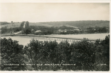
Postcard - Footbridge Lakes Entrance Victoria c1940, No14 Bulmer HD
... Black and white small format postcard of the footbridge across the Cunninghame Arm, which is the access to the southern shore and ocean beach from the town. Lakes Entrance Victoria...1 same image 6.5x10.5 valentine Series donated by Keith West|1 other similar image 6.5 x 10.5|1 other similar image 9 x 14|1 other similar postcard, message on back in Spares Box Bridges Waterways Township Footbridge to Ninety Mile Beach, Lakes Entrance Black and white small format postcard of the footbridge across the Cunninghame Arm, which is the access to the southern shore and ocean beach from the town. Lakes Entrance Victoria Postcard Footbridge Lakes Entrance Victoria c1940 No14 Bulmer HD ...1 same image 6.5x10.5 valentine Series donated by Keith West|1 other similar image 6.5 x 10.5|1 other similar image 9 x 14|1 other similar postcard, message on back in Spares BoxBlack and white small format postcard of the footbridge across the Cunninghame Arm, which is the access to the southern shore and ocean beach from the town. Lakes Entrance VictoriaFootbridge to Ninety Mile Beach, Lakes Entrance bridges, waterways, township -
 Queenscliffe Maritime Museum
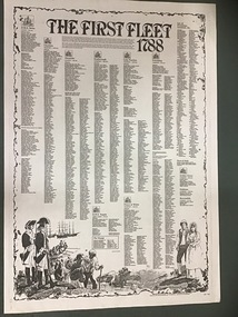
Poster - Copy of Poster listing The First Fleet 1788 passenger lists
... From England, the Fleet sailed south-west to Rio de Janeiro, then east to Cape Town and via the Great Southern Ocean to Botany Bay (Australia), arriving over the period of 18–20 January 1788, taking 250 to 252 days from departure to final arrival. ...From England, the Fleet sailed south-west to Rio de Janeiro, then east to Cape Town and via the Great Southern Ocean to Botany Bay (Australia), arriving over the period of 18–20 January 1788, taking 250 to 252 days from departure to final arrival. ...The First Fleet comprised the 11 ships that departed from Portsmouth, England on 13 May 1787 to New South Wales, the penal colony that became the first European settlement in Australia. The First Fleet consisted of two Royal Navy vessels, three store ships and six convict transports, carrying between 1,000 and 1,500 convicts, marines, seamen, civil officers and free people (accounts differ on the numbers), and a large quantity of stores. From England, the Fleet sailed south-west to Rio de Janeiro, then east to Cape Town and via the Great Southern Ocean to Botany Bay (Australia), arriving over the period of 18–20 January 1788, taking 250 to 252 days from departure to final arrival. During the period 25–26 January 1788 the fleet moved from Botany Bay to present-day Sydney.A poster listing the names of men and women who landed with the first fleet including provisions and livestockThe First Fleet 1788the first fleet, botany bay, sydney -
 Flagstaff Hill Maritime Museum and Village
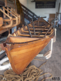
Vehicle - Vessel, Whaleboat, Flagstaff Hill Boat Builders, 1989
... Whaling was carried out in the 1790s up until the 1970s in the Southern Ocean off the coast of Australia, including southwest Victoria. ...Whaling was carried out in the 1790s up until the 1970s in the Southern Ocean off the coast of Australia, including southwest Victoria. ...The Huon Pine whaleboat was made on site by the boat builders at Flagstaff Hill in1989, of the clinker-planked construction method. Whaling was carried out in the 1790s up until the 1970s in the Southern Ocean off the coast of Australia, including southwest Victoria. The whales were hunted for their oil, baleen, meat and other products. It was a lucrative but very dangerous occupation. The small whaleboats with their five crew members were easy to maneuver but also easily overturned by a writhing whale. The Southern Right whales had desirable attributes; they came close to shore, they were slow swimmers and they floated when dead - hence the name 'Right' describing the right whale to hunt. The whale population was greatly reduced until 1979 when the Australian government prohibited whaling. These whales still visit the area annually to breed in the shallow bays along what is now called the Shipwreck Coast of Victoria. The whaleboat represents a significant time in Australia between the 1790s and 1979, when the whaling trade was carried in this area, and around Australia, providing employment and meeting the demand for whale oil, meat and other products. A time during which the population of whales was greatly depleted. Australian whaleboat; a long narrow vessel constructed of clinker-planked Huon Pine timber. It has provision for a crew of 5five oarsmen and a sweep or helmsman. Made in 1989.flagstaff hill maritime museum and village, maritime museum, maritime village, great ocean road, shipwreck coast, whaleboat, vessel, clinker built, huon pine whaleboat, whaling, whaleling industry -
 Lakes Entrance Historical Society
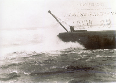
Photograph - Entrance to Gippsland Lakes from Bass Strait 1910c
... Black and white photograph showing ocean and southern end of western pier at entrance to Gippsland Lakes from Bass Strait, in heavy seas at Lakes Entrance, Victoria,...Also one other copy 9 x 12.5 cm Piers Waterways Black and white photograph showing ocean and southern end of western pier at entrance to Gippsland Lakes from Bass Strait, in heavy seas at Lakes Entrance, Victoria, Photograph Entrance to Gippsland Lakes from Bass Strait 1910c ...Also one other copy 9 x 12.5 cmBlack and white photograph showing ocean and southern end of western pier at entrance to Gippsland Lakes from Bass Strait, in heavy seas at Lakes Entrance, Victoria,piers, waterways -
 Mission to Seafarers Victoria
Painting, Ib Odfeldt, MS Nella Dan 1961, 1995
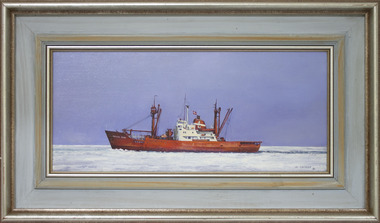
... In 2002 Ib was awarded the Southern Ocean Maritime Art Prize and this acquisition of the Nella Dan is presented in the foyer of the Tasmanian Maritime Museum in Hobart." ...In 2002 Ib was awarded the Southern Ocean Maritime Art Prize and this acquisition of the Nella Dan is presented in the foyer of the Tasmanian Maritime Museum in Hobart." ...A depiction of the MS Nella Dan an active primary vessel built in 1961 by the Aarlborg Shipyard PTY Ltd, and regularly chartered by the Australian National Antarctic Research Expeditions (ANARE) in the 20th C. The ship ran aground in December 1987 and unable to be salvaged, had to be scuttled in deep water off Macquarie Island. See link above, this record. The ship was named after Nel Law wife of the Director of the Antarctic Division, DR Phil Law. "Ib Odfeldt (b. 1944) is a self-taught painter and sculptor spending many years inspired by and interest in ships and marine art whilst working as an engineer in the Danish Merchant Navy. His paintings demonstrate a keen eye for technical accuracy and skill. The balance and setting of his works have attracted interest in many commissions by lovers of marine and shipping works. In 2002 Ib was awarded the Southern Ocean Maritime Art Prize and this acquisition of the Nella Dan is presented in the foyer of the Tasmanian Maritime Museum in Hobart." (The ASMA 2019 National Exhibition - Maritime Museum of Tasmania catalogue). According to the artist, the painting was part of an exhibition he held at "Melbourne maritime museum " (Polly Woodside) to celebrate ANARE (ARTIC SHOW). He donated two paintings of the Nella Dan. Ib Odfledt has also entered the Maritime Art Prize several times. (2012)Maritime ArtFramed , oil on board painting depicting a red hulled , single funnel ship cutting through sea iceArtist signature at lwr right corner PAINTED.: IB ODFELDT 95 At the back: Square loose label: 3076 Leonard Joel Bottom corner on the frame in Pencil: POW 2894 (National Trust accession number)nella dan, anare, antarctica, icebreakers, explorations, merchant vessels, artwork, maritime art, ib odfeldt, artwork-paintings, australian national antarctic research expeditions (anare), hobbies, asma, australian society of maritime artists -
 Flagstaff Hill Maritime Museum and Village
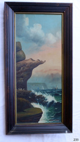
Painting - Oil painting, W. Langley-Taylor, Eagle Rock, Warrnambool, Vic, Late 19th to early 20th century
... This stretch of Warrnambool coastline is exposed to the Southern Ocean. In the painting, the breaking waves and northerly drift of smoke from the steamship suggest a strong southerly wind. ...This stretch of Warrnambool coastline is exposed to the Southern Ocean. In the painting, the breaking waves and northerly drift of smoke from the steamship suggest a strong southerly wind. ...This painting is one of a pair of large works by W. Langley-Taylor in our collection. Further information about the artist has not yet been identified. The pair depicts coastal sites on either side of Port Phillip Bay, south of Melbourne. This work represents Eagle Rock, Warrnambool, on the bay’s western side. Eagle Rock lies about 400 metres west of Thunder Point, near Shelly Beach. The painting shows the cliff formations looking east towards the Warrnambool Breakwater. The site is well known locally, appears in many photographs, and is also a recognised dive location in calm conditions. This stretch of Warrnambool coastline is exposed to the Southern Ocean. In the painting, the breaking waves and northerly drift of smoke from the steamship suggest a strong southerly wind. THE INSCRIPTIONS “Mrs M Irby” and “980/Regency”:- The significance of the inscription “Mrs M Irby”, which appears on the reverse of both paintings, has not been determined. It may refer to the ship or shipping company Irby. Irby was a four-masted iron ship built in Liverpool in 1881. It later traded between London and Australia, including visits to Melbourne and Hobart, before being destroyed by a mine in 1919 while en route to England. Alternatively, “Mrs M Irby” and the pencil inscription “980/Regency” may refer to a delivery address, perhaps an apartment or hotel. This painting is geographically significant for its depiction of Victoria’s coastal scenery. It is also significant as one of a pair of seascapes depicting sites on either side of Port Phillip Bay. Historically, the painting is significant as an example of the late nineteenth- and early twentieth-century methods and materials used in frame construction.Painting oil on board in a dark wooden frame, portrait orientation. Seascape of rock formation and cliffs, two yachts, a two-masted steamboat with red funnel and smoke, flying birds, high waves breaking onto rocks, blue sky with clouds, some tinted pink. The title is painted on the lower left corner, and the artist, W. Langley-Taylor, has signed his name on the lower right. The inscription on the back is handwritten script in red crayon or thick red pencil. The board is held in place inside the timber frame with small, dark metal tacks around all sides. Metal eyes join the wire to the frame. Small, round, dark metal nail heads are dispersed around the frame, and there is a change of colour on both the board and the wood of the frame. Painted on front “W.LANGLEY-TAYLOR.” and “EAGLE ROCK, WARRNAMBOOL, VIC.” Handwritten on back “Mrs. M. Irby” and “980 [underlined] Regency”flagstaff hill, warrnambool, shipwrecked coast, flagstaff hill maritime museum, maritime museum, shipwreck coast, flagstaff hill maritime village, great ocean road, eagle rock warrnambool, w. langley-taylor, oil painting, wall decoration, seascape of victoria's coast, mrs m irby, art, seascape, pair of paintings -
 Flagstaff Hill Maritime Museum and Village
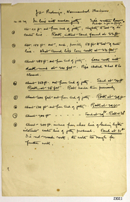
Document - Report, Jet Probings, Warrnambool Harbour, 16-10-1929
... A contract was raised in late 1924 to deposit rubble on the damaged side of the breakwater to minimise the Southern Ocean’s destructive action and work had started by August 1925. ...A contract was raised in late 1924 to deposit rubble on the damaged side of the breakwater to minimise the Southern Ocean’s destructive action and work had started by August 1925. ...This report lists the depths of water and the consistency of the seabed surrounding the Warrnambool Harbour in October 1929, The information, often referred to as 'soundings', was obtained by Jet Probing,. In earlier days a lead line was used to perform a similar task. The author of the document is unknown. Jet Probing is a method used for underwater archaeology, cable installation and coastal engineering. A jet probe is a machine that produces a strong jet of water that penetrates the layers of sediment on the seabed, determining their depth, thickness and consistency. It provides a survey of the seabed and can be used as an aid to engineering design and construction. The report mentions lining up with the wooden jetty, the end of the breakwater and the leading lights. It mentions sand, loose rock and rock. It tells of stopping work due to the water being too rough, the pipe choking, difficulty in connecting pipes, and pipe joint breaking as it tried to get through the sand, The report in the document is significant for its connection with the Warrnambool Harbour, Warrnambool Breakwater, Warrnambool Jetty and Lady Bay. The report gives figures for the depth and consistency of the water and seabed at a particular point in time and can be used to compart with similar figures taken at different times. The results could determine plans for future engineering works.Report, titled 'Jet Probings, Warrnambool Harbour'. Two pages of cream coloured paper with hand written notes in pen and ink. Report covers three days of Jet Probings, with resulting figures and comments, for the depths of the surroundings of the Warrnambool Harbour. The report is in point form, with some underlining. Dates of recordings are 14-10-29, 15-10-29 and 16-10-29. (1929) The situation of the harbour had become a real problem by 1910 and required continuous dredging. In 1914 the Breakwater was extended but proved to be a failure because the work began to subside and by 1920 about two thirds of the harbour was silted up. Alterations made in the 1920's increased the silting problem. The soundings and Jet Probings were done after the Royal Commission of 1923, when the damaged stonework on the seaward side of the Warrnambool Breakwater, caused by the action of the sea, was the subject of enquiry. A conference between the Public Works, Water Commission and the Harbour Trust concluded that it would less costly to make repairs to prevent further damage rather than replaced the damage portion of the wall. A contract was raised in late 1924 to deposit rubble on the damaged side of the breakwater to minimise the Southern Ocean’s destructive action and work had started by August 1925. By the 1940's the harbour was no longer used. More alterations were made in the 1950's and 1960's. document, depth, warrnambool harbour, 1929, soundings, jet probe, jet probing, seabed, map of seabed, underwater engineering, warrnambool jetty, warrnambool breakwater, breakwater upgrade, leading lights, chart the harbour, flagstaff hill, warrnambool, flagstaff hill maritime museum & village, maritime museum, maritime village, shipwreck coast, lady bay, port of warrnambool, breakwater, jetty, pier, vhr h2024, royal commission, 1923, public works, water commission, harbour trust, victorian harbours