Showing 5163 items matching " station road"
-
 Sunshine and District Historical Society Incorporated
Archive - Station Road Deer Park
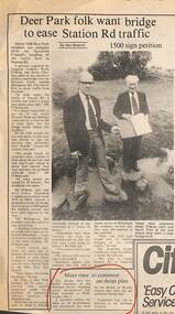
... Station Road Deer Park...Station Road...Collection of documents on Station Road Deer Park...4893.01 - Newspaper Article - Deer Park Folk Want Bridge To Ease Station Road Traffic (Billingham Road To Davitt Drive)...Station Road Deer Club 4893.01 - Newspaper Article - Deer Park Folk Want Bridge To Ease Station Road Traffic (Billingham Road To Davitt Drive) Collection of documents on Station Road Deer Park Archive Station Road Deer Park ...4893.01 - Newspaper Article - Deer Park Folk Want Bridge To Ease Station Road Traffic (Billingham Road To Davitt Drive)station road, deer club -
 Sunshine and District Historical Society Incorporated
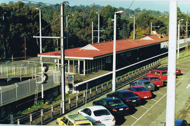
Article - Station Road - Mt. Derrimut Road Deer Park Level Crossing Removal
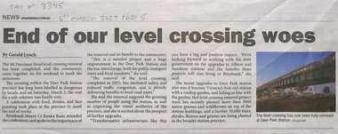
... Station Road - Mt. Derrimut Road Deer Park Level Crossing Removal...Station Road ...Collection of newspaper articles on the Station Road - Mt. Derrimut Road Deer Park Level Crossing Removal...3345.01 - Station Road - Mt. Derrimut Road Deer Park Level Crossing Removal End Of Our Level Crossing Woes.jpg 3345.02 - Station Road - Mt. ...The project also built a new station. Station Road Mt. Derrimut Road Deer Park Railway Railway Station Deer Park Railway Station 3345.01 - Station Road - Mt. ...For many years the level crossing at Deer Park held at the ever increasing traffic in the area. It was also the scene of a number of level crossing accidents. The project also built a new station.3345.01 - Station Road - Mt. Derrimut Road Deer Park Level Crossing Removal End Of Our Level Crossing Woes.jpg 3345.02 - Station Road - Mt. Derrimut Road Deer Park Level Crossing Removal What A Train Wreck.jpg 3345.03 - Station Road - Mt. Derrimut Road Deer Park Level Crossing Removal Mark Knight Cartoon.jpg 3345.04 - Station Road - Mt. Derrimut Road Deer Park Level Crossing Removal - Level Crossing Will Be Gone By July 2023.jpg 3345.05 - Station Road - Mt. Derrimut Road Deer Park Level Crossing Removal - Dear Park Station Wins National Landscape Award.jpgstation road , mt. derrimut road, deer park, railway, railway station, deer park railway station -
 Sunshine and District Historical Society Incorporated
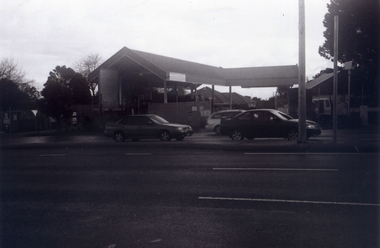
Photograph - I.C.I. Nitrocellulose Plant Station Road Entrance Deer Park 1989 Photograph, C. McGee, 14th April 1989
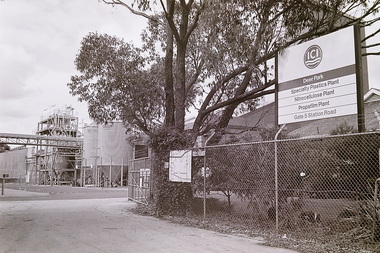
... Nitrocellulose Plant Station Road Entrance Deer Park 1989 Photograph......Station Road...Nitrocellulose Plant on Station Road, Deer Park was part of the ICI Leathercloth Factory, a major industrial complex producing nitrocellulose‑based coated fabrics “Leathercloth”. ...Nitrocellulose Plant Station Road Deer Park...Nitrocellulose Plant Station Road Entrance Deer Park 1989 Photograph C. ...The I.C.I. Nitrocellulose Plant on Station Road, Deer Park was part of the ICI Leathercloth Factory, a major industrial complex producing nitrocellulose‑based coated fabrics “Leathercloth”. It operated as a specialised chemical works linked to explosives, aircraft fabric coatings, and waterproof materials. Nitrocellulose (guncotton reacted with nitric acid) was one of the earliest multi‑use synthetic materials. It was used for Explosives (historical origin of the Deer Park site), Aircraft fabric dope (WWI–WWII aviation coatings), Waterproof cloth and coated textiles and Leathercloth (ICI’s trade name for nitrocellulose‑coated fabric used in cars, furniture, bags, and industrial goods). The Station Road plant specialised in the nitrocellulose coating and finishing processes, not explosives manufacture.The history of the Nitrocellulose Plant is tightly connected to the evolution of the Deer Park explosives precinct and the wider ICI industrial township.I.C.I. Nitrocellulose Plant Station Road Deer Parki.c.i., station road, deer park -
 Sunshine and District Historical Society Incorporated
Letter - City of Sunshine - Commissioner Mr Alexander Alex George Gillon Collection 1976 - 1982 - Deer Park Residents Association Station Road 10th May 1979, Deer Park Residents Association, 10th May 1979
... City of Sunshine - Commissioner Mr Alexander Alex George Gillon Collection 1976 - 1982 - Deer Park Residents Association Station Road 10th May 1979...Station Road...Station Road duplication between Main Road West and Ballarat Road...Station Road Deer Park Station Road duplication between Main Road West and Ballarat Road Foolscap sized document. ...Station Road duplication between Main Road West and Ballarat Roadstation road, deer park -
 Sunshine and District Historical Society Incorporated
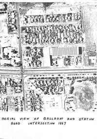
Photograph - Aerial view of Ballarat Road and Station Road Deer Park 1967, 1967
... Aerial view of Ballarat Road and Station Road Deer Park 1967...... Station Road...Aerial view of Ballarat Road and Station Road Deer Park 1967...Ballarat Road Station Road John McLeod Reserve Hume Street Hyde Street Photocopy record of immediate area above the intersection Left top corner Deer Park School and service station and motor vehicles and houses and Deer Park engineering and 2nd service station Bottom left shops and houses Bottom right houses and football ground Top houses Aerial view of Ballarat Road and Station Road Deer Park 1967 Photograph Aerial view of Ballarat Road and Station Road Deer Park 1967 ...Photocopy record of immediate area above the intersection Left top corner Deer Park School and service station and motor vehicles and houses and Deer Park engineering and 2nd service station Bottom left shops and houses Bottom right houses and football ground Top housesballarat road, station road, john mcleod reserve, hume street, hyde street -
 Sunshine and District Historical Society Incorporated
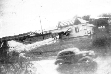
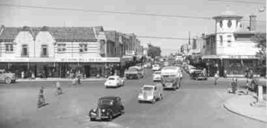
Photograph - Deer Park General Store Ballarat Road Corner Station Road Deer Park, Des Johnson, 1948
... Deer Park General Store Ballarat Road Corner Station Road Deer Park...... Station Road...Photograph Deer Park General Store A weather board building selling Chaff Grain Wood and Petrol from Top of Home and Hovell Corner of Ballarat Road and Station Road. Monument a large blue stone rock near Deer Park State School North of Ballarat Road A Reprint of Original Picture by Des Johnson age 16 years Melway Map 25-E-8...Shop Ballarat Road Station Road Deer Park Photograph Deer Park General Store A weather board building selling Chaff Grain Wood and Petrol from Top of Home and Hovell Corner of Ballarat Road and Station Road. ...Donated by Des Johnson, 29 July, 2011.Photograph Deer Park General Store A weather board building selling Chaff Grain Wood and Petrol from Top of Home and Hovell Corner of Ballarat Road and Station Road. Monument a large blue stone rock near Deer Park State School North of Ballarat Road A Reprint of Original Picture by Des Johnson age 16 years Melway Map 25-E-8shop, ballarat road, station road, deer park -
 Sunshine and District Historical Society Incorporated
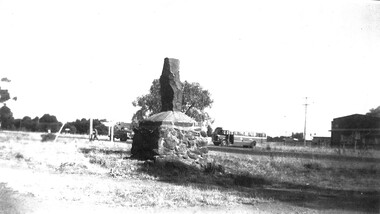
Photograph - Hume and Hovell Monument near Station Road and Ballarat Rd Intersection
... Hume and Hovell Monument near Station Road and Ballarat Rd Intersection...Copy of photograph of Hume and Hovell Monument near Station Road and Ballarat Rd. intersection. A3, b & w.....Photograph Hume and Hovell Monument near Station Road and Ballarat Rd Intersection ...The site of the monument is in front of the former Deer Park State School. In 1991 the monument was moved a short distance to enable the widening of Ballarat Rd.hume and hovell, monument, deer park -
 Sunshine and District Historical Society Incorporated
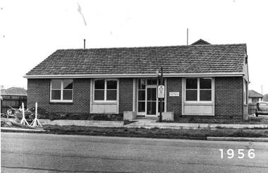
Photograph - Maidstone Police Station Ballarat Road Cnr Short Street 1956 Photographs
... Maidstone Police Station Ballarat Road Cnr Short Street 1956 Photographs...Station...Ballarat Road...The earliest Maidstone Police Station operated on Ballarat Road, address later confirmed as 130 Ballarat Road. ...5358.01 - Maidstone Police Station Ballarat Road Cnr Short Street 1956 Photo 01.jpg 5358.02 - Maidstone Police Station Ballarat Road Cnr Short Street 1956 Photo 01.jpg...Maidstone Police Station Ballarat Road Maidstone 5358.01 - Maidstone Police Station Ballarat Road Cnr Short Street 1956 Photo 01.jpg 5358.02 - Maidstone Police Station Ballarat Road Cnr Short Street 1956 Photo 01.jpg Digital black & white photographs Photograph Maidstone Police Station Ballarat Road Cnr Short Street 1956 Photographs ...The earliest Maidstone Police Station operated on Ballarat Road, address later confirmed as 130 Ballarat Road. Heritage discussions note that the station moved around the corner into Short Street in 1956. It is possible the Ballarat Road building was extended at the rear, facing Short Street, and the operational entrance shifted. The station served Maidstone and Braybrook during the peak years of public housing expansion. Both the Ballarat Road and Short Street police station buildings are now private residencesLocals recall it as the place where many residents obtained their driver’s licences in the 1960s–1970s.5358.01 - Maidstone Police Station Ballarat Road Cnr Short Street 1956 Photo 01.jpg 5358.02 - Maidstone Police Station Ballarat Road Cnr Short Street 1956 Photo 01.jpgmaidstone police station, ballarat road, maidstone -
 Whitehorse Historical Society Inc.
Photograph, The Railway Crossing from Corner of Springvale Road & Station, 1/06/2009
... The Railway Crossing from Corner of Springvale Road & Station....station...springvale road...One of a collection of photographs taken of the Nunawading Railway Station prior to the lowering of the railway line and building of the new railway station on the western side of Springvale Road so that the Springvale Road Rail Crossing can be eliminated....Black & white photograph of he precinct surrounding the Nunawading Station and the Springvale Road Railway crossing. This photograph is of the Railway Crossing from corner of Springvale Road & Station. ...This photograph is of the Railway Crossing from corner of Springvale Road & Station. See NP 3545 to NP3567for the complete set of photographs The Railway Crossing from Corner of Springvale Road & Station. ...One of a collection of photographs taken of the Nunawading Railway Station prior to the lowering of the railway line and building of the new railway station on the western side of Springvale Road so that the Springvale Road Rail Crossing can be eliminated.Black & white photograph of he precinct surrounding the Nunawading Station and the Springvale Road Railway crossing. This photograph is of the Railway Crossing from corner of Springvale Road & Station. See NP 3545 to NP3567for the complete set of photographsnunawading railway station, springvale road, nunawading, redevelopment of railway line/springvale road., station street nunawading -
 Greensborough Historical Society
Photograph - Digital image, Frank Solomon, Greensborough Station from Para Road, 1990c
... Greensborough Station from Para Road....station...para road greensborough...Greensborough Station from the Para Road side of the footbridge overpass....Greensborough Historical Society 34A Glenauburn Road Lower Plenty Lower Plenty melbourne Greensborough Station from the Para Road side of the footbridge overpass. greensborough station para road greensborough Digital copy of colour photograph Greensborough Station from Para Road. ...Greensborough Station from the Para Road side of the footbridge overpass.Digital copy of colour photographgreensborough station, para road greensborough -
 Sunshine and District Historical Society Incorporated
Administrative record - City of Sunshine - Commissioner Mr Alexander Alex George Gillon Collection 1976 - 1982 - Reports of the Town Clerk's Department 10th August 1977, City of Sunshine, 10th August 1977
... ...Station Road...Station Road Drain Council Officers Reports...City of Sunshine Alexander "Alex" George Gillon Station Road Deer Park Station Road Drain Council Officers Reports Foolscap sized document. ...Station Road Drain Council Officers Reports city of sunshine, alexander "alex" george gillon, station road, deer park -
 Box Hill Historical Society
Photograph - Whitehorse Road-Station Street corner, Box Hill, Susan Johns, c1980s
... Whitehorse Road-Station Street corner, Box Hill...Road...Station Street...View over Box Hill from Whitehorse Road and Station Street looking south west towards the water tower (left side of picture) and the Telecom tower (middle of picture on horizon). 2nd photograph is similar view without Tait's corner store. ...Photograph Whitehorse Road-Station Street corner, Box Hill Susan Johns ...View over Box Hill from Whitehorse Road and Station Street looking south west towards the water tower (left side of picture) and the Telecom tower (middle of picture on horizon). 2nd photograph is similar view without Tait's corner store. Photographs taken from the top of one of the counil cherrypickersTwo black & white photographs. whitehorse road, station street, businesses, little johns, ezywalkin, tait's corner store, warlow gallery -
 Sunshine and District Historical Society Incorporated
Administrative record - City of Sunshine - Commissioner Mr Alexander Alex George Gillon Collection 1976 - 1982 - Notice of ordinary meeting of the council 6th May 2026, City of Sunshine, 6th May 1981
... Station Road...Land Transfer Former Right of Way off Station Road Deer Park...Station Road Deer Park Land Transfer Former Right of Way off Station Road Deer Park Foolscap sized document. ...Land Transfer Former Right of Way off Station Road Deer Parkstation road, deer park -
 Eltham District Historical Society Inc
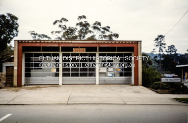
Photograph, Eltham Fire Station, 909 Main Road, Eltham, July 1986
... Eltham Fire Station, 909 Main Road, Eltham...Station...Eltham Shops...Main Road...In 1962, land for a new (fourth) Eltham Fire Station on the opposite (western) side of Main Road was acquired from the Eltham War Memorial Trust. ...Colour photograph of Eltham Fire Station, Main Road, July 1986...eltham fire brigade Eltham Fire Station Eltham Shops Main Road Eltham Colour photograph of Eltham Fire Station, Main Road, July 1986 Eltham Fire Station, 909 Main Road, Eltham Photograph ...Located at 909 Main Road, Eltham. Opened 7 October 1966 Eltham's Fire Stations by Peter Pidgeon Article published EDHS Newsletter No.287 April 2026 Where was Eltham’s first fire station and how many have there been? Following the formation of the Eltham Volunteer Fire Brigade in March 1926, firefighting equipment was initially housed in a shed on Captain H. Warren’s property. A more permanent solution was required. In May 1927 a proposal was made to build a fire station and meeting hall at the corner of Luck Street and Main Road where the present railway station carpark is located. An application was approved by Council in September to build the fire station consisting of a galvanised iron shed on the land in Luck Street, However, in April 1928 when E.O. Egan, Secretary, Eltham Volunteer Fire Brigade sought permission to erect a fire station on the continuation of Luck Street, Council advised they had no power to act on this as they did not own the land. Cr. Ernie Andrew offered to loan a site on his own land in Arthur Street (where the entrance to the carpark under Woolworths is situated) and by September 1928 the new fire station was being erected consisting of a building to house the reel and other equipment as well as a meeting room. It was constructed with a concrete floor and painted. A purpose-built cupboard had been constructed for the hose by local carpenter, Mr. Fraser and Mr. Frank Jones arranged for electric lighting to be installed. Many donations were made by the community to assist in paying off the debt on the station. The first meeting in the new fire station was held November 12, 1928, with a large attendance of members. The official opening was to be held in the New Year on January 8, 1929. In February 1930, Eltham Council agreed to place the Eltham Volunteer Fire Brigade under the control of the Country Fire Brigades’ Board. Further discussions were held in May regarding their area of responsibility to cover as well as questions about a suitable block of land and relocation of the brigade’s buildings. In August 1930, the Chief Officer of Country Fire Board visited Council to select a suitable site. He did not approve of any that Council suggested but encouraged Council to buy land for the purpose. Enquiries were made about a block in Henry Street adjacent to the Public Hall which the Chief Officer favoured. Cr Price investigated and learned the block could be purchased, £10 would secure it if the people of Eltham were willing to raise a further £30-40. All were in favour of proceeding. By February 1931, £40 had been raised by the community, in addition to £20 added by Council and £20 by the Fire Brigades’ Board making £80 total to purchase the site. Several working bees were held between May and July 1931 to level the ground in preparation for relocation of the station building from Arthur Street to the new site in Henry Street. It was not long before the Henry Street site had proven to be not all that was desired. Access to the Henry Street site from Main Road was steep and not suited for man handling a heavy hose reel. By November 1933 the Country Fire Brigades’ Board advised it was considering the matter of a new cation and fire station for Eltham. On February 23, 1934, the Advertiser reported a new Fire Station was to be built on an alternate site at a cost of £600. In August, the Country Fire Brigades’ Board notified it intended to build a new fire station at no cost to Eltham if the brigade could purchase a block of land. An appeal was established by the brigade to raise funds for the purchase of the new site between the residence and confectionery shop owned by Mr. G.H. Browne and Ryan Bros. butchers on the eastern side of Main Road between Arthur and Dudley streets. An inspection of the site by the Chief Officer of Country Fire Brigades' Board was undertaken September 28. It was directed that tenders for the erection of the building were to be called immediately and construction to start the next month. By New Year 1935 the erection of the third station building was well in progress and was completed by mid-February. The station was officially opened April 26, 1935, and a new 35 feet high bell tower was erected in December 1935. This fire station, the third erected in six years, served the community for the next thirty years. In 1962, land for a new (fourth) Eltham Fire Station on the opposite (western) side of Main Road was acquired from the Eltham War Memorial Trust. The new station was opened October 7, 1966. In 1970 the former fire station building on the eastern side of Main Road was relocated to Research Park for use by the 1st Research Scout group. The site is now part of the current Coles supermarket and Eltham Village complex. A new fifth fire station was erected in Brougham Street at a cost of $9.6m and officially opened December 2015. It was intended for use by both career and volunteer firefighters. The former site was to be made available for community access. However, the mixed functional role presented operational difficulties at the new station and after three years, the Eltham CFA volunteers moved back to the former site towards the end of 2018 following a $500,000 upgrade to the facility. So nowadays the career Fire Rescue Victoria members of Eltham Fire Brigade operate out of Eltham’s fifth fire station in Brougham Street and the volunteer Eltham CFA Brigade operate out of Eltham’s fourth station, or could it be considered the sixth?Colour photograph of Eltham Fire Station, Main Road, July 1986eltham fire brigade, eltham fire station, eltham shops, main road eltham -
 Sunshine and District Historical Society Incorporated
Administrative record - City of Sunshine - Commissioner Mr Alexander Alex George Gillon Collection 1976 - 1982 - Attachments for the ordinary meeting 16th May 1978, City of Sunshine, 16th May 1978
... ...Station Road...Heresfield Developments Deer Park Shopping Centre Station Road and Neale Road drainage...City of Sunshine Alexander "Alex" George Gillon Deer Park Shopping Centre Station Road Neale Road Deer Park Heresfield Developments Deer Park Shopping Centre Station Road and Neale Road drainage Foolscap sized document. ...Heresfield Developments Deer Park Shopping Centre Station Road and Neale Road drainage city of sunshine, alexander "alex" george gillon, deer park shopping centre, station road, neale road, deer park -
 Sunshine and District Historical Society Incorporated
Administrative record - City of Sunshine - Commissioner Mr Alexander Alex George Gillon Collection 1976 - 1982 - Recommendations of the forward planning committees 26th February 1981, City of Sunshine, 26th February 1981
... ...Station Road...3 Alice Street Sunshine Drainage 88 Station Road let of house, sale and removal...Alice Street Sunshine Station Road Deer Park 3 Alice Street Sunshine Drainage 88 Station Road let of house, sale and removal Foolscap sized document. ...3 Alice Street Sunshine Drainage 88 Station Road let of house, sale and removalalice street, sunshine, station road, deer park -
 Sunshine and District Historical Society Incorporated
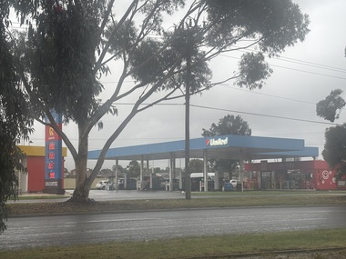
Photograph - Albanvale - Service Station Photographs, John Alchin, 2026
... ...Station Road...5872.01 - Station Road 283 - 285 Albanvale - United Petroleum And Pie Face Service Station.jpeg...Service Station Albanvale Station Road 5872.01 - Station Road 283 - 285 Albanvale - United Petroleum And Pie Face Service Station.jpeg Collection of digital colour photographs Photograph Albanvale - Service Station Photographs John Alchin ...Collection of photographs of current and former service stations in the Albanvale area.5872.01 - Station Road 283 - 285 Albanvale - United Petroleum And Pie Face Service Station.jpegservice station, albanvale, station road -
 Box Hill Historical Society
Photograph - Streetscapes - Whitehorse Road and Station Street, c.1950
... Streetscapes - Whitehorse Road and Station Street...Road...Station Street...View of the intersection of Whitehorse Road and Station Streets looking south down Station Street, featuring cars, trucks, buses, pedestrians and shops....Whitehorse Road and Station Street cnr., Box Hill, Victoria, Australia...Streetscapes Whitehorse Road Station Street Businesses Ron R. Watkins Boys & Mens Wear Watkins> Ron R. ...View of the intersection of Whitehorse Road and Station Streets looking south down Station Street, featuring cars, trucks, buses, pedestrians and shops.B&w photostreetscapes, whitehorse road, station street, businesses, ron r. watkins boys & mens wear, watkins> ron r., taits corner stores, may> e. b., transport, ezywalkin, edna barnett sportswear, barnett> edna, bus services -
 Sunshine and District Historical Society Incorporated
Administrative record - City of Sunshine - Commissioner Mr Alexander Alex George Gillon Collection 1976 - 1982 - Notice of committee meetings 8th December 1980, City of Sunshine, 3rd December 1980
... ...Station Road...Rates, Sanitary & Interest Statements as at 17th November 1980 Neale Road and Station Road Intersection Hersfield Developments...Neale Road Station Road Deer Park Rates, Sanitary & Interest Statements as at 17th November 1980 Neale Road and Station Road Intersection Hersfield Developments Foolscap sized document. ...Rates, Sanitary & Interest Statements as at 17th November 1980 Neale Road and Station Road Intersection Hersfield Developmentsneale road, station road, deer park -
 Sunshine and District Historical Society Incorporated
Administrative record - City of Sunshine - Commissioner Mr Alexander Alex George Gillon Collection 1976 - 1982 - Matters Arising Agenda And Forward Committee 30th October 1979, City of Sunshine, 29th October 1979
... Station Road...Station Road Widing Planning Permit Extensions to shopping centre Rosamond Road Princess Street Arcade car parking...Station Road Deer Park Highpoint West Rosamond Road Maribyrnong Princess Street St. ...Station Road Widing Planning Permit Extensions to shopping centre Rosamond Road Princess Street Arcade car parkingstation road, deer park, highpoint west, rosamond road, maribyrnong, princess street, st. albans -
 Sunshine and District Historical Society Incorporated
Photograph - Sydenham Railway Station Gates Keilor - Melton Road Sydenham 1966 Photograph, 4th March 1966
... Sydenham Railway Station Gates Keilor - Melton Road Sydenham 1966 Photograph...Station...Keilor - Melton Road...In 1887, the Keilor Road Station was renamed to Sydenham. The crossing remained essential for farmers moving between the Keilor Plains and the Calder district. ...Sydenham Railway Station Keilor - Melton Road Sydenham Digital black & white photograph Photograph Sydenham Railway Station Gates Keilor - Melton Road Sydenham 1966 Photograph ...The Sydenham level crossing gates at Keilor–Melton Road operated from the mid 1800s. The railway crossing was required when the Bendigo line opened in 1859. The crossing was a simple gated level crossing that existed to allow farm traffic across the line. The nearby station was called Keilor Road. In 1887, the Keilor Road Station was renamed to Sydenham. The crossing remained essential for farmers moving between the Keilor Plains and the Calder district. The gates remained manually operated, with railway staff responsible for opening and closing the gates. These gates operated until 2002, and when the original Sydenham Station closed, the gates were replaced with traffic lights In 2018, the entire crossing was permanently removed with a grade separation as part of the State Government Level Crossing Removal Project.sydenham railway station, keilor - melton road, sydenham -
 Sunshine and District Historical Society Incorporated
Administrative record - City of Sunshine - Commissioner Mr Alexander Alex George Gillon Collection 1976 - 1982 - Extraordinary business 5th August 1980, City of Sunshine, 5th August 1980
... Station Road...Planning Permit Flats Station Road Dangerous Building 12 - 14 Drummartin Street Albion Height of Fences 37 Wintersun Drive Albanvale...Station Road Deer Park Drummartin Street Albion Wintersun Drive Albanvale Planning Permit Flats Station Road Dangerous Building 12 - 14 Drummartin Street Albion Height of Fences 37 Wintersun Drive Albanvale Foolscap sized document. ...Planning Permit Flats Station Road Dangerous Building 12 - 14 Drummartin Street Albion Height of Fences 37 Wintersun Drive Albanvalestation road, deer park, drummartin street, albion, wintersun drive, albanvale -
 Sunshine and District Historical Society Incorporated
Administrative record - City of Sunshine - Commissioner Mr Alexander Alex George Gillon Collection 1976 - 1982 - Matters Arising From Agenda Committee 8th December 1980, City of Sunshine, 8th December 1980
... ...Station Road...Golf Course Maribyrnong River Proposed Public Toilet Ballarat Road Deer Park Lot 1 Station Road Albanvale Children's Community Centre...Maribyrnong River Golf Course Ballarat Road Deer Park Station Road Albanvale Golf Course Maribyrnong River Proposed Public Toilet Ballarat Road Deer Park Lot 1 Station Road Albanvale Children's Community Centre Foolscap sized document. ...Golf Course Maribyrnong River Proposed Public Toilet Ballarat Road Deer Park Lot 1 Station Road Albanvale Children's Community Centremaribyrnong river, golf course, ballarat road, deer park, station road, albanvale -
 Sunshine and District Historical Society Incorporated
Administrative record - City of Sunshine - Commissioner Mr Alexander Alex George Gillon Collection 1976 - 1982 - Extraordinary business 2nd September 1980, City of Sunshine, 2nd September 1980
... Station Road...Planning Permit Flats 21 Station Road Deer Park Location of Building 35 Cooke Avenue Sunshine North 12 - 14 Drummartin Street Albion...Station Road Deer Park Cooke Avenue Sunshine North Drummartin Street Albion Planning Permit Flats 21 Station Road Deer Park Location of Building 35 Cooke Avenue Sunshine North 12 - 14 Drummartin Street Albion Foolscap sized document. ...Planning Permit Flats 21 Station Road Deer Park Location of Building 35 Cooke Avenue Sunshine North 12 - 14 Drummartin Street Albionstation road, deer park, cooke avenue, sunshine north, drummartin street, albion -
 Sunshine and District Historical Society Incorporated
Administrative record - City of Sunshine - Commissioner Mr Alexander Alex George Gillon Collection 1976 - 1982 - Minutes of the ordinary meeting of council held on 16th May 1978, City of Sunshine, 16th May 1978
... ...Station Road...Lease Italo-Australian Co-Operative Social Club Proposed closure of Stanley Street transfer to the Commonwealth Department Proposed shopping centre corner of Neale Road and Station Road construction of drainage, etc...Albans Deer Park Shopping Centre Station Road Neale Road Deer Park Stanley Street Lease Italo-Australian Co-Operative Social Club Proposed closure of Stanley Street transfer to the Commonwealth Department Proposed shopping centre corner of Neale Road and Station Road construction of drainage, etc Foolscap sized document. ...Lease Italo-Australian Co-Operative Social Club Proposed closure of Stanley Street transfer to the Commonwealth Department Proposed shopping centre corner of Neale Road and Station Road construction of drainage, etc city of sunshine, alexander "alex" george gillon, italo-australian co-operative social club, furlong road, st. albans, deer park shopping centre, station road, neale road, deer park, stanley street -
 Ringwood and District Historical Society
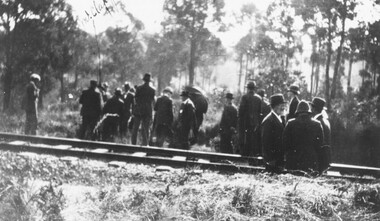
Photograph, Deputation of East Ringwood locals wanting rail station at Eastfield Road, 24/4/23. {Written on back}
... Deputation of East Ringwood locals wanting rail station at Eastfield Road, 24/4/23. {Written on back}...Written on rear of photograph, "Deputation of locals wanting rail station at Eastfield Road, 24/4/23"....Ringwood and District Historical Society 125A Warrandyte Road Ringwood North melbourne Written on rear of photograph, "Deputation of locals wanting rail station at Eastfield Road, 24/4/23". ...Black and white photographWritten on rear of photograph, "Deputation of locals wanting rail station at Eastfield Road, 24/4/23". -
 Melbourne Tram Museum
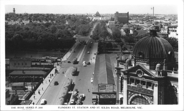
Postcard, Rose Stereograph Co, "Flinders St, Station and St Kilda Road, Melbourne", 1941
... "Flinders St, Station and St Kilda Road, Melbourne"...Station...St Kilda Road...Rose Series postcard P.200, "Flinders St, Station and St Kilda Road, Melbourne" looking south from the roof top of the Nicholas Building in Swanston Street. ...Yields information about St Kilda Road 1941 tramways Flinders St Station St Kilda Road Railways World War II trams MMTB Swanston St W2 class Rose Series Postcard - printed real photograph with Rose Stereograph Co. name on the rear. ...Rose Series postcard P.200, "Flinders St, Station and St Kilda Road, Melbourne" looking south from the roof top of the Nicholas Building in Swanston Street. Has at least eight trams in the view. The trams have a white panel under the driver's windows indicating a war time black out precaution. Has adverts for buying bonds and savings certificates and The Herald learn to Swim advertisement on the end of the verandah for Friday next January 10th at Princes Bridge. This gives a year of 1941.Yields information about St Kilda Road 1941Postcard - printed real photograph with Rose Stereograph Co. name on the rear.tramways, flinders st station, st kilda road, railways, world war ii, trams, mmtb, swanston st, w2 class, rose series -
 Sunshine and District Historical Society Incorporated
Administrative record - City of Sunshine - Commissioner Mr Alexander Alex George Gillon Collection 1976 - 1982 - Extraordinary business 22nd July 1980, City of Sunshine, 22nd July 1980
... ...Station Road...Planning Permit Application Retail Plant Nursey Ballarat Road Deer Park Installation of Traffic Lights Mitchell Street, Hampstead Road and Omar Street Maidstone Station Road Widening...Ballarat Road Station Road Deer Park Mitchell Street Hampstead Road Omar Street Maidstone Planning Permit Application Retail Plant Nursey Ballarat Road Deer Park Installation of Traffic Lights Mitchell Street, Hampstead Road and Omar Street Maidstone Station Road Widening Foolscap sized document. ...Planning Permit Application Retail Plant Nursey Ballarat Road Deer Park Installation of Traffic Lights Mitchell Street, Hampstead Road and Omar Street Maidstone Station Road Wideningballarat road, station road, deer park, mitchell street, hampstead road, omar street, maidstone -
 Sunshine and District Historical Society Incorporated
Photograph - Deer Park - Service Station Photographs, John Alchin, 2026
... ...Station Road...5869.01 - Neale Road 28 - 72 Deer Park - Ampol Service Station 2026.jpeg 5869.02 - Station Road 810 Deer Park - United Petroleum And Pie Face 2026.jpeg 5869.03 - Station Road Cnr Canterbury Street Deer Park - Former Service Station Site 2026.jpeg 5869.04 - Mt. ...Service Station Deer Park Station Road Mt. Derrimut Road Neale Road 5869.01 - Neale Road 28 - 72 Deer Park - Ampol Service Station 2026.jpeg 5869.02 - Station Road 810 Deer Park - United Petroleum And Pie Face 2026.jpeg 5869.03 - Station Road Cnr Canterbury Street Deer Park - Former Service Station Site 2026.jpeg 5869.04 - Mt. ...Collection of photographs of current and former service stations in the Deer Park area.5869.01 - Neale Road 28 - 72 Deer Park - Ampol Service Station 2026.jpeg 5869.02 - Station Road 810 Deer Park - United Petroleum And Pie Face 2026.jpeg 5869.03 - Station Road Cnr Canterbury Street Deer Park - Former Service Station Site 2026.jpeg 5869.04 - Mt. Derrimut Road 75 Deer Park - Ampol Service Station And Foodary 2026 Photo 01.JPGservice station, deer park, station road, mt. derrimut road, neale road -
 Ringwood and District Historical Society
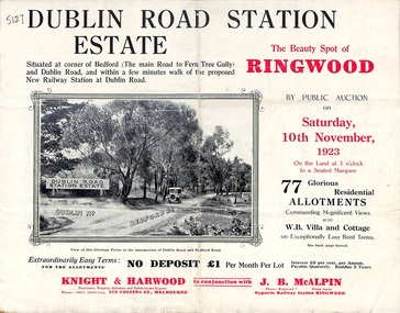
Pamphlet, Land Sale Brochure, Dublin Road Station Estate - 1923
... Land Sale Brochure, Dublin Road Station Estate - 1923...The deputation urged that there were 81 passengers who, if the station were provided, would make daily use of it, and that as the Commissioners had purchased a site for a station at Dublin-road it was evident they had at one time considered it the most suitable site. ...Brochure includes subdivision features, local facilities and photographic images of the area and details of proposed new railway station at Dublin Road....Road). Auctioneer - Knight & Harwood, 315 Collins Street, Melbourne, Phones Central 10615, 10616. Agent - J.B. McAlpin, Opposite Railway Station, Ringwood, Phone Ringwood 7....Brochure includes subdivision features, local facilities and photographic images of the area and details of proposed new railway station at Dublin Road. Land Sale Brochure, Dublin Road Station Estate - 1923 Pamphlet ..."Extracts from Recent Daily Newspaper - Ringwood Train Service - STATION WANTED AT RINGWOOD EAST. A deputation from the Ringwood East Railway League and Progress Association waited on the chairman of the Railway Commissioners yesterday afternoon and asked that a railway station be erected at Dublin-road, a mile and a quarter from Ringwood. The deputation urged that there were 81 passengers who, if the station were provided, would make daily use of it, and that as the Commissioners had purchased a site for a station at Dublin-road it was evident they had at one time considered it the most suitable site. The Chairman of Commissioners stated that the estimated cost of the station was £3700. Land owners in the locality should pay a proportion of the cost. Members of the deputation replied that there would be no difficulty in raising the money."Multi-fold brochure advertising public auction of residential allotments on Saturday, 10th November, 1923. Brochure includes subdivision features, local facilities and photographic images of the area and details of proposed new railway station at Dublin Road.Subdivision plan includes Dublin Road, Alexandra Road, Vonadawn Avenue, Green Street, Howard Avenue, Wood Street, and Bedford Road (Main Ferntree Gully Road). Auctioneer - Knight & Harwood, 315 Collins Street, Melbourne, Phones Central 10615, 10616. Agent - J.B. McAlpin, Opposite Railway Station, Ringwood, Phone Ringwood 7.