Showing 4 items matching " terrick terrick west"
-
 Bendigo Historical Society Inc.
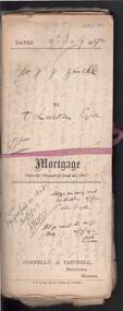
Document - CONNELLY, TATCHELL, DUNLOP COLLECTION: MORTGAGE MR. J.J. JEWELL TO T. LUXTON ESQ
... ... Terrick Terrick West...Luxton , The Exchange, Collins St., Melbourne for land at Parish of Terrick Terrick West, County of Gunbower, mortgage document dated 4th. ...History House 11 Mackenzie Street Bendigo goldfields COTTAGE Miners Joshua James Jewell Thomas Luxton Terrick Terrick West Gunbower mortgage Connelly Tatchell & Paling S. ...Documents relating to mortgage between Mr. Joshua James Jewell of Mitiamo, farmer, and Mr. T. Luxton , The Exchange, Collins St., Melbourne for land at Parish of Terrick Terrick West, County of Gunbower, mortgage document dated 4th. July 1892. Contains 3 Conditions of Sale documents, newspaper clipping re clearing sale of 2600 acres of land on behalf of Mr. J.J. Jewell, farming implements, machinery, household effects at 'The Hill' Mitiamo.. Letters relating to transactions re above mortgage enclosed, including discharge of mortgage handwritten document between Sarah Berges and Joshua J. Jewell. Note name change from Connelly & Tatchell, to Connelly, Tatchell & Paling. Letter enclosed in file from Mr. Joshua Jewell, 'The Hill' Mitiamo, Oct 4th., 1893 to Mr. T, Luxton, requesting ' waiting another (?) for money I will be able to pay it before the month is up but at present I cannot meet it. I have just commenced to shear and of course money will be coming in now'cottage, miners, joshua james jewell, thomas luxton, terrick terrick west, gunbower, mortgage, connelly, tatchell & paling, s. berges, connelly, tatchell & dunlop, paling. -
 Bendigo Historical Society Inc.
Map - CAMPBELL COLLECTION: BENDIGO AND DISTRICT MAPS, 14-6-29
... Terricks, Parish of Terrick Terrick West, scale 20 chains to 1 inch, total area 6318 acres, prepared in W.P.B. from Assessment and Parish Plans by W.J.G. 14-6-29. ...Terricks, Parish of Terrick Terrick West, scale 20 chains to 1 inch, total area 6318 acres, prepared in W.P.B. from Assessment and Parish Plans by W.J.G. 14-6-29. ...Map. Terricks, Parish of Terrick Terrick West, scale 20 chains to 1 inch, total area 6318 acres, prepared in W.P.B. from Assessment and Parish Plans by W.J.G. 14-6-29. (number 388 in map cupboard 1)W.J.Galbraithmap, bendigo, agricultural lands -
 Bendigo Historical Society Inc.
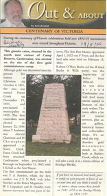
Newspaper - Newspaper articles by Ken Arnold, Out &About, 2000 - 2003
... West School 20.9.02 108. Runnymede area 27.9.02 109. Wanalta 4.10.02 110. School Sites. Between Wanalta and Carop 11.10.02 111. Burramboot 18.10.02 112. Kangaroo Chair. 25.10.02 113. Mincha South 1.11.02 114. Woodlands Church 8.11.02 115. School site. Sylvaterre 15.11.02 116. Terrick Terrick...West School 20.9.02 108. Runnymede area 27.9.02 109. Wanalta 4.10.02 110. School Sites. Between Wanalta and Carop 11.10.02 111. Burramboot 18.10.02 112. Kangaroo Chair. 25.10.02 113. Mincha South 1.11.02 114. Woodlands Church 8.11.02 115. School site. Sylvaterre 15.11.02 116. Terrick Terrick ...Ken Arnold is a Bendigo author and publisher.A series of one hundred and thirty-five articles written by Ken Arnold and published in the Bendigo Weekly between 2000 and 2003. Each article has a topic or theme and includes historical information and details. Each article includes a photograph. The articles are stored in a red vinyl covered two ring A5 folder. Index below. Number Article Name Date 1. Centenary of Victoria 19.5.00 2. Storm Water Drain 26.5.00 3. Granite Rollers 2.6.00 4. Poverty Mine 9.6.00 5. Golden Monument. St Arnaud 16.6.00 6. Turner Statue 7.7.00 7. Gold Monument. High St Golden Square 30.6.00 8. Gold Monument. Howard Square Bendigo 14.7.00 9. Lansell Statue 21.7.00 10. Shelbourne West School 18.8.00 11. Mologa’s State Schools 25.8.00 12. Salinity Stone. Pyramid Hill 1.9.00 13. Cairn. Carisbrook 8.9.00 14. Commemorative Markers. Taradale 15.9.00 15. Burke Monument. Castlemaine 22.9.00 16. Cairn. Harcourt area 29.9.00 17. Cairn Marks Gold Route 6.10.00 18. Volcanic Rock Cairn. Woodstock 13.10.00 19. Garfield Water Wheel 20.10.00 20. Anticline. Castlemaine 27.10.00 21. Lawson Bridge 10.11.00 22. Plaque. Sutton Grange area 17.11.00 23. Memorial Cairn. Maryborough 1.12.00 24. Lonely Grave 8.12.00 25. Moonlight Flat Church 5.1.01 26. Historic Church. Near Tullaroop reservoir 12.1.01 27. Granite Statue. Castlemaine 19.1.01 28. Marker. Near Tullaroop reservoir 25.1.01 29. Church Site. Mologa 2.2.01 30. Church Site. Mologa 9.2.01 31. Plaque. Mologa 16.2.01 32. Mincha School 23.2.01 33. Historic Marker. Mincha 2.3.01 34. Expedition Marker. Pyramid Hill 9.3.01 35. Irrigation Marker. Tragowel 16.3.01 36. Mologa School Sites 23.3.01 37. Cairn. Pyramid Hill 30.3.01 38. Plaque. Pyramid Hill 6.4.01 39. Bristol Hill Lookout Tower. Maryborough 12.4.01 40. Eppalock Reservoir 20.4.01 41. Colbinabbin Cairn 27.4.01 42. Mount Macedon Cross 4.5.01 43. Memorial Gateway. Macedon 11.5.01 44. Cairn. Daylesford 18.5.01 45. Grave. Carlsruhe 25.5.01 46. Water Tower. Elmore 1.6.01 47. State School Site. Glenalbyn 8.6.01 48. Cairn. Kanya 15.6.01 49. Lonely Grave. Wedderburn 22.6.01 50. Church Cairn. Glenalbyn 29.6.01 51. Kamarooka School 6.7.01 52. Granite Marker. Moyston 13.7.01 53. Memorial Park. Kerang 20.7.01 54. Water Plaque. Bears Lagoon 27.7.01 55. Cemetery. Bears Lagoon 3.8.01 56. Race Monument 10.8.01 57. Cairn. Pyalong 17.8.01 58. Cairn. In memory of Edward Parker 24.8.01 59. Mt Macedon 31.8.01 60. Mt Macedon Cairn 7.9.01 61. Expedition Pass. Chewton 14.9.01 62. Granite Archway. St Arnaud 21.9.01 63. Stuart Mill School Site 28.9.01 64. School Site. Beazley’s Bridge 5.10.01 65. Fosterville 12.10.01 66. Barnadown 19.10.01 67. Salisbury School Site 26.10.01 68. Cricket History at Wattle Flat 2.11.01 69. School Site. Waterloo Plains 9.11.01 70. Carapooee School Site 11.01 71. Turkish Gun. Maldon 11.01 72. Kooreh 30.11.01 73. Marnoo East School 7.12.01 74. Bulgana Site 14.12.01 75. Emu School 21.12.01 76. Kooroocheang 4.1.02 77. Church Site. Gre Gre North 11.1.02 78. Carmens Tunnel. Maldon 18.1.02 79. Monument. Maldon 25.1.02 80. Woodfull Plaques. Maldon 1.2.02 81. Carapooee. St Peters Anglican Church 8.2.02 82. Cairn. Kingower 15.2.02 83. Cob & Co Stopover. Rheola 22.2.02 84. Flynn Monument 1.3.02 85. The Welcome Stranger. Moliagul 8.3.02 86. Campbell’s Creek Reserve 15.3.02 87. Mine. Fryerstown 22.3.02 88. Escott Grave. Near Chewton 28.3.02 89. School No 808. Kurting area 5.4.02 90. Graves. Bendigo Creek 10.5.02 91. School. Fish Point, Benjeroop North 17.5.02 92. Old Township. Diggora 24.5.02 93. Diggora West (1) 31.5.02 94. Diggora West (2) 7.6.02 95. School No 2735. Gower East 14.6.02 96. Pannoomilloo 21.6.02 97. Kamarooka Settlement 28.6.02 98. Mincha West State School No 1931 5.7.02 99. Bridges. Arnold 12.7.02 100. Woodvale 19.7.02 101. A Famous Son of Raywood. Jack Donaldson 26.7.02 102. Tandarra Area Schools 2.8.02 103. Dingee 9.8.02 104. Avonmore 30.8.02 105. Myola East School 6.9.02 106. Colbinabbin West 13.9.02 107. Colbinabbin West School 20.9.02 108. Runnymede area 27.9.02 109. Wanalta 4.10.02 110. School Sites. Between Wanalta and Carop 11.10.02 111. Burramboot 18.10.02 112. Kangaroo Chair. 25.10.02 113. Mincha South 1.11.02 114. Woodlands Church 8.11.02 115. School site. Sylvaterre 15.11.02 116. Terrick Terrick 22.11.02 117. Leitchville 29.11.02 118. Pennyweight Cemetery. Castlemaine 6.12.02 119. Mincha Area 13.12.02 120. Musk School 20.12.02 121. Dowie Park. Carisbrook 3.1.03 122. Neereman School Site 10.1.03 123. Bald Rock 17.1.03 124. Sylvaterre School Site 24.1.02 125. Carlsruhe 31.1.02 126. Athenaeum. Maldon 7.2.03 127. School. Mincha West 14.2.03 128. Yarraberb 21.2.03 129. Settlement Marker. Ravenswood Estate 28.2.03 130. Comini Reserve. Ravenswood 7.3.03 131. Ironbark and Gold Track. Whroo 14.3.03 132. Burke and Wills Obelisk. Castlemaine 21.3.03 133. James Cook Statue. Myers St Bendigo 28.3.03 134. St Marys Church. Axedale 4 .4.03 135. Butter Factory Site. Warragamba 11.4.03 events, monuments, historical sites, landmarks -
 National Wool Museum
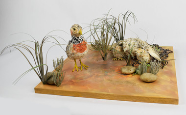
Artwork, other - Paper Taxidermy, Mary-Jane Walker, Plains Wanderer, 2020
... After years of low numbers in Victoria, plains-wanderer populations have been increasing in Terrick Terrick National Park in north west Victoria, as sheep grazing maintains the grass in the park at a suitable level. ...Terrick Terrick National Park in north west Victoria, as sheep grazing maintains the grass in the park at a suitable level. With the right management, this ecologically important bird species is continuing to survive in the native grasslands of Victoria. Managing these habitats for the plains-wanderer can also support the conservation of many other threatened plant and animal species. Object: Nest of plains-wanderers by Mary-Jane Walker, 2020. Outer made from upcycled paper, internal structure steel. native grasslands plains-wanderer Terrick ...The world’s most ecologically distinct bird lives in the native grasslands of Victoria - but only just. The plains-wanderer is a small bird that was once widespread across the grasslands of south-eastern Australia. Today there are fewer than 1000 mature birds in the wild. The plains-wanderer is under threat due to habitat loss caused by overgrazing, cropping and suburban sprawl. Unlike most other birds, female wanderers are larger and more colourful and the males take care of the chicks. They are only about 15cm tall and weigh between 40-80g for the male and 55-90g for the female. Their intricate plumage mirrors the colours of their grassland home so they blend in perfectly with their surroundings. The plains-wanderer’s origins date back to when Australia was part of the Gondwana supercontinent over 60 million years ago. They are so biologically distinct that their extinction would result in the loss of a branch of the tree of life. A fussy grass dweller, they like neither too much nor too little grass. That is where sheep grazing can help. After years of low numbers in Victoria, plains-wanderer populations have been increasing in Terrick Terrick National Park in north west Victoria, as sheep grazing maintains the grass in the park at a suitable level. With the right management, this ecologically important bird species is continuing to survive in the native grasslands of Victoria. Managing these habitats for the plains-wanderer can also support the conservation of many other threatened plant and animal species. Object: Nest of plains-wanderers by Mary-Jane Walker, 2020. Outer made from upcycled paper, internal structure steel. Nest of plains-wanderers by Mary-Jane Walker, 2020. Outer made from up cycled paper, internal structure steel. native grasslands, plains-wanderer, terrick terrick national park