Showing 577 items matching " toilets"
-
 Ballarat Heritage Services
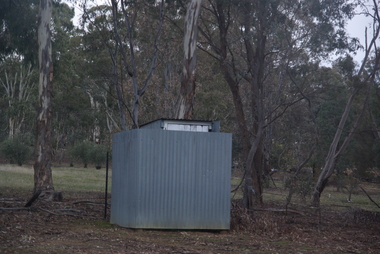
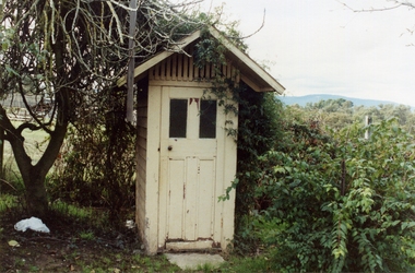
Photograph - Colour, Clare Gervasoni, Toilets at Sandon Cemetery, 2017, 16/07/2017
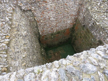
... Toilets at Sandon Cemetery, 2017......toilets...Colour photograph of the long drop toilet at Sandon Catholic Cemetery. ...Ballarat Heritage Services PO Box 2209 Bakery Hill Post Office goldfields sandon sandon cemetery toilets Long drop toilet Colour photograph of the long drop toilet at Sandon Catholic Cemetery. ...Colour photograph of the long drop toilet at Sandon Catholic Cemetery. sandon, sandon cemetery, toilets, long drop toilet -
 Ballarat Heritage Services
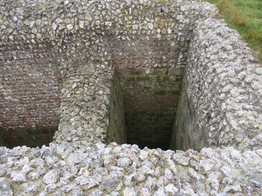
Photograph - Photograph - Colour, Castle toilets, Old Sarum, England, 2016, 01/11/2016
... Castle toilets, Old Sarum, England, 2016......toilets...Colour photographs of Castle toilets at Old Sarum, England. The toilets are constructed of stone. ...The toilets are constructed of stone. Castle toilets, Old Sarum, England, 2016 Photograph Photograph - Colour ...William the Conqueror inherited Old Sarum from the last Saxon king of England. It was an ideal site for a royal castle. It was here in 1070 that William paid off his army after a long and bitter campaign in northern England. It was here in 1086 that he called together all the major landholders in England so they could swear allegiance to him. It was a crucial moment. The Domesday Book was being written, a threatened Viking invasion had only just been averted and William's eldest son was in armed rebellion. Old Sarum was an important place where this Norman king of England held power. In 1794 the Ordnance Survey set out to check the accuracy of the first mapping of Southern England, which had begun ten years earlier. From a point just below Old Sarum Lieutenant William Mudge laid out a base-line 36,574 feet (11,253 metres) long. From each end of the line the positions of distant places were plotted using a huge theodolite made in 1791 by Jesse Ramsden. The accuracy of the process, which was repeated all over England, depended on Jesse Ramsden's craftsmanship and on William Mudge's surveying skill in setting out this first base-line from Old Sarum. The nearer end of Mudge's line is marked by an inscribed stone beside the modern A345 at Old Sarum. Colour photographs of Castle toilets at Old Sarum, England. The toilets are constructed of stone. ordnance survey, william mudge, jesse ramsden, william the conqueror, old sarum, saxon, 1086, england, subjects, toilets -
 Kew Historical Society Inc
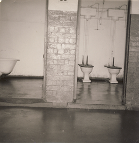
Photograph, Communal Toilets, Kew Mental Hospital, 1956, 1956
... Communal Toilets, Kew Mental Hospital, 1956...Black and white photograph of patient toilets in the Kew Mental Hospital. ...The album and its photographs are however an historically significant visual record of the Kew Mental Hospital, especially in the years 1951-1965. kew lunatic asylum kew hospital for the insane kew mental hospital kew mental institute willsmere mental hospital willsmere hospital "1956" Black and white photograph of patient toilets in the Kew Mental Hospital. Communal Toilets, Kew Mental Hospital, 1956 Photograph ...This photograph is one of approximately 43 original photographs and photocopies of buildings, patients and staff assembled in a red covered, spirally bound photograph album (the album itself is now discarded and the images stored separately). The images in the album cover the period from the 1870s to 1965. A few photographs have inscriptions on the reverse; others had later separate labels in the album. The album was presumably compiled as a public record. It and other items came from the collection assembled by Dr Fred Stamp, the last medical superintendent of Willsmere Hospital before its closure in 1988. Original photographs have been uploaded to and described on Victorian Collections. The album itself is listed and linked separately showing the photographs in situ.A number of the photographs from the Willsmere Hospital album are confronting, especially given the condition of the buildings and facilities depicted, as well as the casual photographs of patients, which some viewers may find distressing. The album and its photographs are however an historically significant visual record of the Kew Mental Hospital, especially in the years 1951-1965.Black and white photograph of patient toilets in the Kew Mental Hospital. "1956"kew lunatic asylum, kew hospital for the insane, kew mental hospital, kew mental institute, willsmere mental hospital, willsmere hospital -
 Ballarat Heritage Services
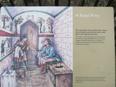
Photograph - Colour, Sign Explaining toilets, Old Sarum, England, English Heritage Site, 01/11/2016
... Sign Explaining toilets, Old Sarum, England, English Heritage Site...Colour photograph of a sign explaining toilets at Old Sarum, English Heritage Site...The nearer end of Mudge's line is marked by an inscribed stone beside the modern A345 at Old Sarum. ordnance survey william mudge jesse ramsden william the conqueror old sarum saxon 1086, england Colour photograph of a sign explaining toilets at Old Sarum, English Heritage Site Sign Explaining toilets, Old Sarum, England, English Heritage Site Photograph - Colour ...William the Conqueror inherited Old Sarum from the last Saxon king of England. It was an ideal site for a royal castle. It was here in 1070 that William paid off his army after a long and bitter campaign in northern England. It was here in 1086 that he called together all the major landholders in England so they could swear allegiance to him. It was a crucial moment. The Domesday Book was being written, a threatened Viking invasion had only just been averted and William's eldest son was in armed rebellion. Old Sarum was an important place where this Norman king of England held power. In 1794 the Ordnance Survey set out to check the accuracy of the first mapping of Southern England, which had begun ten years earlier. From a point just below Old Sarum Lieutenant William Mudge laid out a base-line 36,574 feet (11,253 metres) long. From each end of the line the positions of distant places were plotted using a huge theodolite made in 1791 by Jesse Ramsden. The accuracy of the process, which was repeated all over England, depended on Jesse Ramsden's craftsmanship and on William Mudge's surveying skill in setting out this first base-line from Old Sarum. The nearer end of Mudge's line is marked by an inscribed stone beside the modern A345 at Old Sarum. Colour photograph of a sign explaining toilets at Old Sarum, English Heritage Siteordnance survey, william mudge, jesse ramsden, william the conqueror, old sarum, saxon, 1086,, england -
 Whitehorse Historical Society Inc.
Photograph, Toilets - Schwerkolt Cottage & Museum complex
... Toilets - Schwerkolt Cottage & Museum complex...Coloured photograph of new toilets erected at the Schwerkolt Cottage and Museum complex, 2003...Whitehorse Historical Society Inc. 2-10 Deep Creek Road Mitcham melbourne schwerkolt cottage and museum complex Coloured photograph of new toilets erected at the Schwerkolt Cottage and Museum complex, 2003 Toilets - Schwerkolt Cottage & Museum complex Photograph Photograph ...Coloured photograph of new toilets erected at the Schwerkolt Cottage and Museum complex, 2003schwerkolt cottage and museum complex -
 Whitehorse Historical Society Inc.
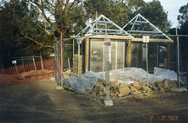
Photograph, Toilets, Schwerkolt Cottage, 7/07/2003 12:00:00 AM
... Toilets, Schwerkolt Cottage...Coloured - New 'Super-loo' toilets in the process of being built at Schwerkolt Cottage and Museum complex...Whitehorse Historical Society Inc. 2-10 Deep Creek Road Mitcham melbourne schwerkolt cottage and museum complex arrowsmith ted Coloured - New 'Super-loo' toilets in the process of being built at Schwerkolt Cottage and Museum complex Toilets, Schwerkolt Cottage Photograph Photograph ...Coloured - New 'Super-loo' toilets in the process of being built at Schwerkolt Cottage and Museum complexschwerkolt cottage and museum complex, arrowsmith, ted -
 Ringwood and District Historical Society
Photograph, Edwin G. Adamson A.R.P.S, Toilets in Civic Place, Ringwood 1962 (Eastland Litigation Photos)
... Toilets in Civic Place, Ringwood 1962 (Eastland Litigation Photos)...Written on back of photograph 2838-2: 'Photo of the toilets in Civic Place, showing doors broken off where pans slide into toilets. ...Written on back of photograph 2838-2: 'Photo of the toilets in Civic Place, showing doors broken off where pans slide into toilets. ...This series of SS0380 photos are part of the "Eastland Litigation" launched in 1962 by the Whitehorse Traders Co-operative Association (WTCA), against the Ringwood Council's Interim Development Order of 1960. WTCA sought "orders from the Supreme Court of Victoria that the planning scheme was invalid" - See "The Eastland Litigation" chapter in "From Horse Shoes to High Heels - Ringwood Shopping Centre and Eastland 1858-2008" by Richard Carter, Bounce Books 2009.2xBlack and WHite PhotographsWritten on back of photograph 2838-1: 'Photo of the toilets in Civic Place, showing doors broken off. See pan exposed to public view'. Stamped on photograph, 'Edwin G. Adamson...May 62'. Written on back of photograph 2838-2: 'Photo of the toilets in Civic Place, showing doors broken off where pans slide into toilets. Pans open to air, flies, etc. Used by occupiers of 'The Block'. Stamped on photographs, 'In the Supreme Court 13 Aug 1963' and 'Edwin G. Adamson...May 63'. -
 Whitehorse Historical Society Inc.
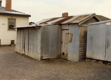
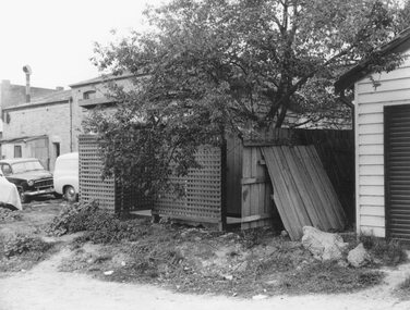
Photograph, Toilets Mitcham Memorial Hall
... Toilets Mitcham Memorial Hall...Coloured photo of Corrugated Iron Toilets and Storage Shed at rear of Mitcham Memorial Hall in Whitehorse Road, Mitcham, since demolished....Toilets Mitcham Memorial Hall Photograph Photograph ...Coloured photo of Corrugated Iron Toilets and Storage Shed at rear of Mitcham Memorial Hall in Whitehorse Road, Mitcham, since demolished.mitcham memorial hall, grant, max -
 Ringwood and District Historical Society
Photograph, Edwin G. Adamson A.R.P.S, Toilets in Civic Place, Ringwood, used by occupiers of 'The Block''. 1963 (Eastland Litigation Photo)
... Toilets in Civic Place, Ringwood, used by occupiers of 'The Block''. 1963 (Eastland Litigation Photo)...Written on back of photographs, 'Photo of toilets in Civic Place, used by occupiers of 'The Block''. ...Written on back of photographs, 'Photo of toilets in Civic Place, used by occupiers of 'The Block''. ...This series of SS0380 photos are part of the "Eastland Litigation" launched in 1962 by the Whitehorse Traders Co-operative Association (WTCA), against the Ringwood Council's Interim Development Order of 1960. WTCA sought "orders from the Supreme Court of Victoria that the planning scheme was invalid" - See "The Eastland Litigation" chapter in "From Horse Shoes to High Heels - Ringwood Shopping Centre and Eastland 1858-2008" by Richard Carter, Bounce Books 2009.Black and White PhotographWritten on back of photographs, 'Photo of toilets in Civic Place, used by occupiers of 'The Block''. Also stamped on photographs, 'Edwin G. Adamson...May 63' and 'In the Supreme Court, 1 Aug. 1963'. -
 Heidelberg Golf Club
Photograph, Heidelberg Golf Club: Clubhouse renovations 1997-98 - Men's toilets and handbasins, 1997
... Heidelberg Golf Club: Clubhouse renovations 1997-98 - Men's toilets and handbasins ...Heidelberg Golf Club: Clubhouse renovations 1997-98 - Men's toilets and handbasins almost complete ...Heidelberg Golf Club 8 Main Road Lower Plenty 3093 Heidelberg Golf Club: Clubhouse renovations 1997-98 - Men's toilets and handbasins almost complete Clubhouse redevelopment 1998 HGC Clubhouse 1997 Bryn Teg Men's toilets Colour photograph and caption, in album Heidelberg Golf Club: Clubhouse renovations 1997-98 - Men's toilets and handbasins Photograph Photograph ...Heidelberg Golf Club: Clubhouse renovations 1997-98 - Men's toilets and handbasins almost complete Colour photograph and caption, in albumclubhouse redevelopment 1998, hgc clubhouse 1997, bryn teg, men's toilets -
 Eltham District Historical Society Inc
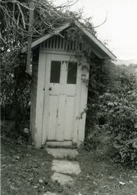
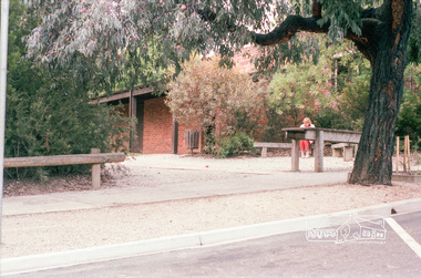
Photograph, Public toilets, Were Street, Montmorency, c.1990
... Public toilets, Were Street, Montmorency...Photographs of public land in Were Street, Montmorency with public toilets. Before the the erection of the wind mill. ...Brick paved footpath, angle parking and two public phone boxes. montmorency public tiolets were street Parks Public Toilets shopping centres 6 colour photographs (2 sets) Public toilets, Were Street, Montmorency Photograph Photograph ...Photographs of public land in Were Street, Montmorency with public toilets. Before the the erection of the wind mill. Brick paved footpath, angle parking and two public phone boxes.6 colour photographs (2 sets)montmorency, public tiolets, were street, parks, public toilets, shopping centres -
 Ringwood and District Historical Society
Photograph-B&W, Hill's Dairy, Canterbury Road, Ringwood 1989-Outside Toilet, 6/07/1989
... Hill's Dairy, Canterbury Road, Ringwood 1989-Outside Toilet...Hill's Dairy, Canterbury Road, Ringwood 1989-Outside Toilet...Toilet...Ringwood and District Historical Society 125A Warrandyte Road Ringwood North melbourne Toilet Hill's Dairy, Canterbury Road, Ringwood 1989-Outside Toilet Hill's Dairy, Canterbury Road, Ringwood 1989-Outside Toilet Photograph-B&W ...Hill's Dairy, Canterbury Road, Ringwood 1989-Outside ToiletToilet -
 Ringwood and District Historical Society
Photograph-Colour, Hill's Dairy, Canterbury Road, Ringwood 1989-Outside Toilet, 6/07/1989
... Hill's Dairy, Canterbury Road, Ringwood 1989-Outside Toilet...Hill's Dairy, Canterbury Road, Ringwood 1989-Outside Toilet...Toilet...Ringwood and District Historical Society 125A Warrandyte Road Ringwood North melbourne Toilet Hill's Dairy, Canterbury Road, Ringwood 1989-Outside Toilet Hill's Dairy, Canterbury Road, Ringwood 1989-Outside Toilet Photograph-Colour ...Hill's Dairy, Canterbury Road, Ringwood 1989-Outside ToiletToilet -
 Whitehorse Historical Society Inc.
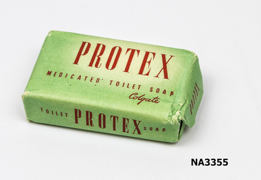
Functional object - Toilet soap, c 1950
... Cake of toilet soap wrapped in pale green paper with red printing...Protex medicated toilet soap. Colgate...Whitehorse Historical Society Inc. 2-10 Deep Creek Road Mitcham melbourne domestic items ablutions Protex medicated toilet soap. Colgate Cake of toilet soap wrapped in pale green paper with red printing Functional object Toilet soap ...Cake of toilet soap wrapped in pale green paper with red printingProtex medicated toilet soap. Colgatedomestic items, ablutions -
 Eltham District Historical Society Inc
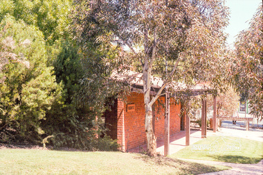
Photograph, Public toilets, Montmorency Shopping Centre, Were Street
... Public toilets, Montmorency Shopping Centre, Were Street...Eltham District Historical Society Inc 728 Main Rd Eltham melbourne montmorency were street shopping centre Kodak CP 100 5094 Roll of 35mm colour negative film, 3 of 5 strips Public toilets, Montmorency Shopping Centre, Were Street Photograph ...Roll of 35mm colour negative film, 3 of 5 stripsKodak CP 100 5094montmorency, were street, shopping centre -
 Eltham District Historical Society Inc
Photograph, Marjorie North, Public toilets, Montmorency shops, Were Street, 1986, 1986
... Public toilets, Montmorency shops, Were Street, 1986...Eltham District Historical Society Inc 728 Main Rd Eltham melbourne Negatives supplied by Marjorie North 1 July 1986 for Montmorency France album montmorency were street shopping centre Kodak CL 200 5093 Roll of 35mm colour negative film, 3 strips Public toilets, Montmorency shops, Were Street, 1986 Photograph Marjorie North ...Negatives supplied by Marjorie North 1 July 1986 for Montmorency France albumRoll of 35mm colour negative film, 3 stripsKodak CL 200 5093montmorency, were street, shopping centre -
 Ballarat Heritage Services
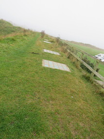
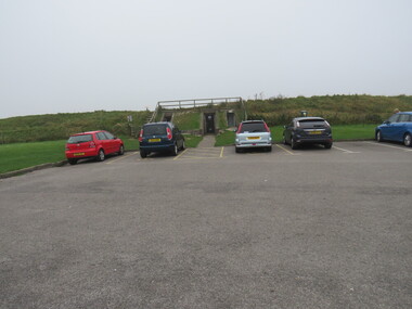
Photograph - Colour, Public toilets hidden in earth mound, Old Sarum, England, English Heritage Site, 2016, 01 November 2016
... Public toilets hidden in earth mound, Old Sarum, England, English Heritage Site, 2016...The nearer end of Mudge's line is marked by an inscribed stone beside the modern A345 at Old Sarum. ordnance survey, william mudge, jesse ramsden, william the conqueror, old sarum, saxon, 1086, england Public toilets hidden in earth mound, Old Sarum, England, English Heritage Site, 2016 Photograph - Colour ...William the Conqueror inherited Old Sarum from the last Saxon king of England. It was an ideal site for a royal castle. It was here in 1070 that William paid off his army after a long and bitter campaign in northern England. It was here in 1086 that he called together all the major landholders in England so they could swear allegiance to him. It was a crucial moment. The Domesday Book was being written, a threatened Viking invasion had only just been averted and William's eldest son was in armed rebellion. Old Sarum was an important place where this Norman king of England held power. In 1794 the Ordnance Survey set out to check the accuracy of the first mapping of Southern England, which had begun ten years earlier. From a point just below Old Sarum Lieutenant William Mudge laid out a base-line 36,574 feet (11,253 metres) long. From each end of the line the positions of distant places were plotted using a huge theodolite made in 1791 by Jesse Ramsden. The accuracy of the process, which was repeated all over England, depended on Jesse Ramsden's craftsmanship and on William Mudge's surveying skill in setting out this first base-line from Old Sarum. The nearer end of Mudge's line is marked by an inscribed stone beside the modern A345 at Old Sarum. ordnance survey, william mudge, jesse ramsden, william the conqueror, old sarum, saxon, 1086, england -
 Ballarat Heritage Services
Photograph - Colour, Entrance to Public toilets hidden in earth mound, Old Sarum, England, English Heritage Site, 2016, 01 November 2016
... Entrance to Public toilets hidden in earth mound, Old Sarum, England, English Heritage Site, 2016...The nearer end of Mudge's line is marked by an inscribed stone beside the modern A345 at Old Sarum. ordnance survey, william mudge, jesse ramsden, william the conqueror, old sarum, saxon, 1086, england Entrance to Public toilets hidden in earth mound, Old Sarum, England, English Heritage Site, 2016 Photograph - Colour ...William the Conqueror inherited Old Sarum from the last Saxon king of England. It was an ideal site for a royal castle. It was here in 1070 that William paid off his army after a long and bitter campaign in northern England. It was here in 1086 that he called together all the major landholders in England so they could swear allegiance to him. It was a crucial moment. The Domesday Book was being written, a threatened Viking invasion had only just been averted and William's eldest son was in armed rebellion. Old Sarum was an important place where this Norman king of England held power. In 1794 the Ordnance Survey set out to check the accuracy of the first mapping of Southern England, which had begun ten years earlier. From a point just below Old Sarum Lieutenant William Mudge laid out a base-line 36,574 feet (11,253 metres) long. From each end of the line the positions of distant places were plotted using a huge theodolite made in 1791 by Jesse Ramsden. The accuracy of the process, which was repeated all over England, depended on Jesse Ramsden's craftsmanship and on William Mudge's surveying skill in setting out this first base-line from Old Sarum. The nearer end of Mudge's line is marked by an inscribed stone beside the modern A345 at Old Sarum. ordnance survey, william mudge, jesse ramsden, william the conqueror, old sarum, saxon, 1086, england -
 Ballarat Heritage Services
Photograph - Colour, Toilets, Old Sarum, England, English Heritage Site, 2016, 01 November 2016
... Toilets, Old Sarum, England, English Heritage Site, 2016...The nearer end of Mudge's line is marked by an inscribed stone beside the modern A345 at Old Sarum. ordnance survey, william mudge, jesse ramsden, william the conqueror, old sarum, saxon, 1086, england Toilets, Old Sarum, England, English Heritage Site, 2016 Photograph - Colour ...William the Conqueror inherited Old Sarum from the last Saxon king of England. It was an ideal site for a royal castle. It was here in 1070 that William paid off his army after a long and bitter campaign in northern England. It was here in 1086 that he called together all the major landholders in England so they could swear allegiance to him. It was a crucial moment. The Domesday Book was being written, a threatened Viking invasion had only just been averted and William's eldest son was in armed rebellion. Old Sarum was an important place where this Norman king of England held power. In 1794 the Ordnance Survey set out to check the accuracy of the first mapping of Southern England, which had begun ten years earlier. From a point just below Old Sarum Lieutenant William Mudge laid out a base-line 36,574 feet (11,253 metres) long. From each end of the line the positions of distant places were plotted using a huge theodolite made in 1791 by Jesse Ramsden. The accuracy of the process, which was repeated all over England, depended on Jesse Ramsden's craftsmanship and on William Mudge's surveying skill in setting out this first base-line from Old Sarum. The nearer end of Mudge's line is marked by an inscribed stone beside the modern A345 at Old Sarum. ordnance survey, william mudge, jesse ramsden, william the conqueror, old sarum, saxon, 1086, england -
 Wonga Park Community Cottage History Group
Plan (Item) - Building Plan, Wonga Park Hall: Plan of new toilets and renovations Probably late 1970s or early 1980s
... Wonga Park Hall: Plan of new toilets and renovations Probably late 1970s or early 1980s...Wonga Park Community Cottage History Group Unit 1, 9 – 13 Old Yarra Road Wonga Park melbourne Wonga Park Hall: Plan of new toilets and renovations Probably late 1970s or early 1980s Plan Building Plan ... -
 Dutch Australian Heritage Centre Victoria
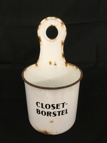
Toilet Brush Holder
... White enamelled metal cylindrical toilet brush holder. An upright projection has a hole for optional hanging of the object....CLOSET BORSTEL (Toilet Brush) in black paint....An upright projection has a hole for optional hanging of the object. Toilet Brush Holder ...This item is from the pre-plastic days and would have contained a brush made from natural bristles.White enamelled metal cylindrical toilet brush holder. An upright projection has a hole for optional hanging of the object.CLOSET BORSTEL (Toilet Brush) in black paint. -
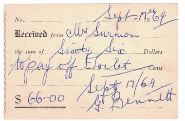 Linton and District Historical Society Inc
Receipt, Receipt issued to Mrs. Surman, 1969
... Bennett to Mrs Surman for sixty-six dollars, to "pay off toilet" in Church of England, Linton....Surman / the sum of Sixty Six Dollars / to pay off Toilet"....Surman / the sum of Sixty Six Dollars / to pay off Toilet". Receipt issued by G. Bennett to Mrs Surman for sixty-six dollars, to "pay off toilet" in Church of England, Linton. ...Money raised by Mrs Surman and donated to the Church of England, Linton.Receipt issued by G. Bennett to Mrs Surman for sixty-six dollars, to "pay off toilet" in Church of England, Linton.Text: "Received from Mrs. Surman / the sum of Sixty Six Dollars / to pay off Toilet".stella surman, g. bennett, church of england linton, receipts -
 Puffing Billy Railway
Toilet Roll Holder, 1 NBC, circa 4/ 2/1899
... 1 NBC Toilet Roll Holder Toilet roll holder that was located in 1 NBC when obtained in the 1990s Carriage 1 NBC was built 4/ 2/1899 NWS Built new at Newport Workshops ...1 NBC Toilet Roll Holder made of cast wrought iron ...Puffing Billy Railway 1 old monbulk road Belgrave yarra-valley-and-the-dandenong-ranges 1 NBC Toilet Roll Holder Toilet roll holder that was located in 1 NBC when obtained in the 1990s Carriage 1 NBC was built 4/ 2/1899 NWS Built new at Newport Workshops Historic - Victorian Railways - Carriage Toilet Roll Holder from 1 NBC carriage puffing billy 1 nbc toilet roll holder 1 NBC Toilet Roll Holder made of cast wrought iron 1 NBC Toilet Roll Holder Victorian Railways - Newport Workshop ...1 NBC Toilet Roll Holder Toilet roll holder that was located in 1 NBC when obtained in the 1990s Carriage 1 NBC was built 4/ 2/1899 NWS Built new at Newport Workshops Historic - Victorian Railways - Carriage Toilet Roll Holder from 1 NBC carriage1 NBC Toilet Roll Holder made of cast wrought iron puffing billy, 1 nbc toilet roll holder -
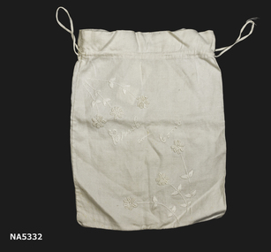 Whitehorse Historical Society Inc.
Textile - Toilet bag
... Handmade toilet bag. Example of container for personal items. ...Cotton cream drawstring toilet bag for brush & comb....Textile Toilet bag McNamara Family ...Handmade toilet bag. Example of container for personal items. Donated by Heather McNamara - worked by Isobel McNamara.Cotton cream drawstring toilet bag for brush & comb.toilet bag, frush & comb container, cotton, embroidered -
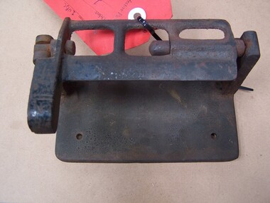
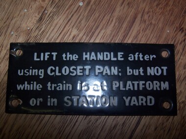 Puffing Billy Railway
Carriage Toilet sign
... Carriage Toilet sign Lift the Handle after using closet pan : but not while train is at Platform or in station yard...Carriage Toilet sign made of enamel paint on metal ...Puffing Billy Railway 1 old monbulk road Belgrave yarra-valley-and-the-dandenong-ranges Carriage Toilet sign Lift the Handle after using closet pan : but not while train is at Platform or in station yard Historic - Railways - Carriage Toilet sign puffing billy carriage toilet sign Lift the Handle after using closet pan : but not while train is at Platform or in station yard Carriage Toilet sign made of enamel paint on metal Carriage Toilet sign ...Carriage Toilet sign Lift the Handle after using closet pan : but not while train is at Platform or in station yardHistoric - Railways - Carriage Toilet signCarriage Toilet sign made of enamel paint on metal Lift the Handle after using closet pan : but not while train is at Platform or in station yardpuffing billy, carriage toilet sign -
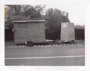 Kew Historical Society Inc
Photograph - Workmen's Hut and Toilet, Stevenson Street, 1972
... The four-sided portable toilet has a metal frame. Th exact location has not been identified. ..."WORKMEN'S HUT & TOILET / STEVENSON ST 8/9/72 / (THESE ARE THE UNITS WHICH WERE IN SWINTON AV. 30/8/72)"...Photograph Workmen's Hut and Toilet, Stevenson Street ...One of a series of photographs donated by the City Engineer of the former City of Kew, relating to road works. The photos variably include council workers, signage and equipment.One of a series of photographs of core local government services as practised by the City of Kew. The photographs are an accurate record of street works of the period.Original black and white photographic positive of a portable workmen's hut and toilet in Stevenson Street, Kew in September 1972. The hut is made of wooden boards with a corrugate iron roof. The four-sided portable toilet has a metal frame. Th exact location has not been identified. "WORKMEN'S HUT & TOILET / STEVENSON ST 8/9/72 / (THESE ARE THE UNITS WHICH WERE IN SWINTON AV. 30/8/72)"city of kew, local government -- city of kew, road works, street works, stevenson street -- kew (vic.) -
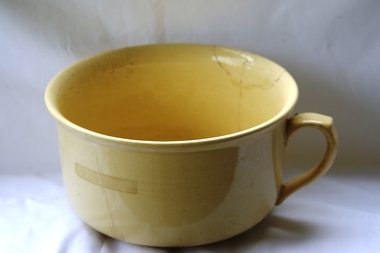 Greensborough Historical Society
Domestic object - Chamberpot, Hoffman Co, 1930c
... ...toilets...Used as toilet receptacle in bedroom, where toilet facilities not conveniently available....Greensborough Historical Society 34A Glenauburn Road Lower Plenty Lower Plenty melbourne Used as toilet receptacle in bedroom, where toilet facilities not conveniently available. chamberpots bedrooms toilets Hoffman (stamped on base) Ceramic chamberpot, cream glaze, single handle. ...Used as toilet receptacle in bedroom, where toilet facilities not conveniently available.Ceramic chamberpot, cream glaze, single handle. Caneware glaze, clear glaze over clay.Hoffman (stamped on base)chamberpots, bedrooms, toilets -
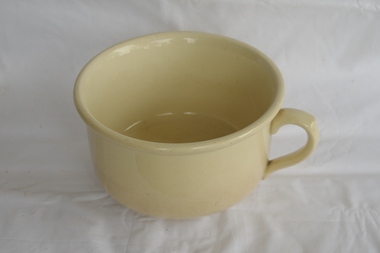 Greensborough Historical Society
Domestic object - Chamberpot, Hoffman Co, 1930c
... ...toilets...Used as toilet receptacle in bedroom, where toilet facilities not conveniently available....Greensborough Historical Society 34A Glenauburn Road Lower Plenty Lower Plenty melbourne Used as toilet receptacle in bedroom, where toilet facilities not conveniently available. chamberpots bedrooms toilets Hoffman (moulded on base) Ceramic chamberpot, cream glaze, single handle. ...Used as toilet receptacle in bedroom, where toilet facilities not conveniently available.Ceramic chamberpot, cream glaze, single handle. Caneware glaze, clear glaze over clay.Hoffman (moulded on base)chamberpots, bedrooms, toilets -
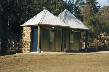
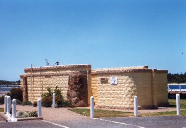 Lakes Entrance Historical Society
Photograph, Holding M, Eastern wharf public toilet block, Lakes Entrance Victoria, 1998c
... Eastern wharf public toilet block, Lakes Entrance Victoria...Bricks for toilet block construction were made at Kimmells farm by Clyde Worseldine, Tambo Shire employee after WW2...Colour photograph of the toilet block situated on the eastern wharf precinct, showing a public toilet block constructed of concrete bricks made locally, entrances faced with local stone. ...Lakes Entrance Historical Society 4 Marine Parade Lakes Entrance gippsland Bricks for toilet block construction were made at Kimmells farm by Clyde Worseldine, Tambo Shire employee after WW2 Jetties Public facilities Colour photograph of the toilet block situated on the eastern wharf precinct, showing a public toilet block constructed of concrete bricks made locally, entrances faced with local stone. ...Bricks for toilet block construction were made at Kimmells farm by Clyde Worseldine, Tambo Shire employee after WW2Colour photograph of the toilet block situated on the eastern wharf precinct, showing a public toilet block constructed of concrete bricks made locally, entrances faced with local stone. Lakes Entrance Victoriajetties, public facilities -
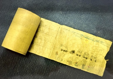 Tatura Irrigation & Wartime Camps Museum
Toilet roll paper- illustrated, 1940's
... School work of 6-7 year old Gretl Frank on standard issue toilet paper in Camp 3. Gretl was the daughter of Kurt and Emma Frank...Illustrated paper toilet roll. School work. Text in German...School work. Text in German Toilet roll paper- illustrated ...School work of 6-7 year old Gretl Frank on standard issue toilet paper in Camp 3. Gretl was the daughter of Kurt and Emma FrankIllustrated paper toilet roll. School work. Text in Germantoilet roll, paper, school, frank g, hurnung g, camp 3, tatura, war camps, documents, education